
This interview, which has been edited for length, is also available as a Land Matters podcast.
A native Vermonter who was first elected in 2012, Miro Weinberger is serving his fourth term as the mayor of Burlington, Vermont. He attended Yale and Harvard’s Kennedy School of Government, and worked for Habitat for Humanity before founding his own affordable housing development company. He’s also a part-time athlete, playing catcher in an amateur over-35 baseball league.
Vermont has long been a progressive kind of place with a population dedicated to environmental measures, whether solar and wind power, electric vehicles, or sustainable farming practices. Burlington, its change-agent capital—the place that gave rise to Bernie Sanders, who served as mayor from 1981 to 1989—became the first city in the country to source 100 percent of its energy from renewables in 2014, a goal set in 2004. Now Weinberger and other leaders are building on that foundation, committing to shifting the city’s energy, transportation, and building sectors away from fossil fuels entirely.
ANTHONY FLINT: Tell us about this ambitious goal of becoming a net-zero energy city by 2030. What is that going to look like, and what are the steps to make that happen?
MIRO WEINBERGER: As a result of decades of commitment to more efficient buildings and weatherization, Burlington uses less electricity as a community in 2022 than we did in 1989, despite the proliferation of new electrical devices and whatnot . . . that sounds exceptional, and it is. If the rest of the country had followed that trajectory, we’d have something like 200 less coal-burning plants today than we do.
When we became a 100 percent renewable electricity city in 2014, there was enormous interest in how Burlington had gotten here. After talking to film crews from South Korea and France and answering question after question about how we did this, I came to think we had achieved it for two big reasons. One, there was political will. Second, we had a city-owned electric department that had a lot of technical expertise and that was able to make this transformation to renewables affordable.
The way we are defining net zero is to essentially not use fossil fuels in—or have a net-zero fossil-fuel use in—three sectors. For the electricity sector, we’re already there. That gets [us] about 25 percent toward the total goal. The [others are the] ground transportation sector and the thermal sector—how we heat and cool our buildings.
The big strategies are electrifying everything, electrifying all the cars and trucks that are based here in Burlington. Moving the heating and cooling of our buildings to various electric technologies, the most common one probably being cold-climate heat pumps. Then, rounding out the strategies, we are looking to implement a district energy system that would capture waste heat [from the city’s biomass facility] and use it to heat some of our major institutional buildings. Then we also are making changes to our transportation network to make active transportation account for more of our vehicle trips and bring down fossil-fuel use that way as well. Those are the major roadmap strategies.
AF: Is there one component of this that you have found particularly tough in terms of trying to go citywide?
MW: In general, I’ve been really pleased with our progress. We actually found in our first update in 2021, we were on target to meet this incredibly ambitious goal of essentially phasing out fossil fuels by 2030. Part of that, admittedly, was that, as we all know, 2020 was a pretty exceptional year and we did see transportation-related emissions drop as a result of the pandemic. We just got a new measurement and we did see some rebounding, so that we are not quite on track through two years the way we were [after] one. The rebound that happened here in Burlington was about a quarter of the nationwide rebound in emissions. Basically, we had a 1.5 percent increase in emissions after the pandemic, whereas the rest of the country grew by 6 percent. We’ve seen a rapid increase in the adoption of heat pumps and electric vehicles over the last couple of years since we came forward with what we call green stimulus incentives very early in the pandemic.
That said, I often have this sensation that we are fighting this battle with one hand tied behind our back, because it is not a level playing field for new electrification and renewable technologies. The costs of burning fossil fuels are not properly reflected in the economics right now. We need a price on carbon in some form. The fact that we don’t have that holds us back. When we get that—and I do think it’s just inevitable that eventually we will get this policy right, like a growing number of jurisdictions around the world—I think we’re going to have a wind at the back of all these initiatives. It will help with everything we’re trying to do.
AF: Now, I want to make sure I understand. Do you want everyone in the city of Burlington to operate an electric vehicle by 2030? Is it that kind of scaling up and adoption?
MW: Basically, yes. That is what it would really take to fully achieve the goal, that or some offset investments to help us get there, but we are very serious about doing everything we can to bring about as quickly as possible this transformation.
A year ago, we passed a zoning ordinance that [says] new construction in Burlington cannot burn fossil fuels as the primary heating source. We didn’t prohibit fossil fuels—we thought that was too onerous, and the technology’s just not there to go that far. Regulating the primary heating source can bring down the impact of a new building by as much as 85 percent. In recent weeks, the state signed off on a change to our charter that gives us the ability to go beyond that and put new regulations in place for all buildings in Burlington. By next town meeting day, next March, we plan to have in front of the voters a new ordinance that would start to put requirements in place for the transformation of mechanical systems for major new and existing buildings when they get to the end of their useful life. When water heaters break, for example, we are both going to have this strategy through our utility, offering very generous incentives, and have actual regulatory standards in place that require transformation.
AF: I want to ask about the utilities. You mentioned Burlington Electric and then, of course, you have Green Mountain Power. How important is that piece, given that utility companies elsewhere seem to be wary of renewables and may even end up hindering that transition?
MW: I’ve got to say, a decade in office grappling with these issues has made me a big believer in publicly owned power. All of the work that I described over the last 30-plus years, the city-owned electric department has been a big part of that. Municipalities, towns, mayors that don’t have their own electric utility, I think it’s harder. I do think there are things that any local community can do to collaborate with and, when necessary, bring public pressure to bear on utilities, which tend to have to answer to some public regulatory authority. I think that there are ways to push other utilities to do what Burlington Electric is doing. I think it’s an exciting story in Vermont that the other utility that has really been quite innovative, Green Mountain Power, is an investor-owned utility.
If we get anywhere near this net-zero goal, it’s going to mean we’re selling a whole lot more electricity than we are now. We estimate at least 60 percent more electricity than today. Every time someone buys an electric vehicle and charges it up in Burlington now, and they do it at night, we’re able to sell them off-peak power in a way that just brings more dollars into the utility. It’s very good, the economics. That’s why we’re able to offer these very generous incentives—every time we bring another electric vehicle or heat pump online, that’s a new revenue stream to the city. These incentives in many ways largely pay for themselves with that new revenue. To me, it seems like good business sense as well to move in this direction.
AF: Vermont has become a very popular destination for mostly affluent climate refugees [who are] buying up land and building houses. What are the pros and cons of this?
MW: You’re right, we are seeing climate refugees here. We also had pandemic refugees. We’ve seen big new pressures on our housing markets, and that’s the downside. We’ve long had an acute housing crisis, [but] it’s worse than it’s ever been now. The silver lining of that may be it may finally force Vermont to get serious about putting in place land use rules at the local and state level that make it possible to build more housing.
We desperately need more housing. We’ve got to get better about that, and I think there’ll be environmental benefits if we do. To me, more people living in a green city like Burlington is a good trade-off for the environment.
AF: Are there other strategies that you have in mind for keeping or making green Burlington affordable? Burlington has a successful community land trust, you encourage accessory dwelling units, you have inclusionary zoning . . . what’s next?
MW: We have a lot of work to do on our zoning ordinance and our statewide land use reform. Many projects in Vermont now—good projects, good green, energy-efficient projects in settled areas—have to go through both local and statewide land use permitting processes, an almost entirely redundant process that slows things down, adds a lot of costs, and creates all sorts of opportunity for obstruction. We have a lot of work to do and we’re focused on it. There are three major upzoning efforts that we’re pursuing right now and there’s a big conversation about Act 250 [Vermont’s land use and development law] reform happening in the state as well.
AF: Finally, what advice do you have for other city leaders to take similar climate action, especially in places that aren’t primed for it quite as well as Burlington is?
MW: Whenever I talk to other mayors about this, I try to make the point that this is an area where political leadership [and community will] can have a huge impact. When I came into office, we had almost no deployed solar here in Burlington. We made it a priority. We changed some rules about permitting. We made it easier for consumers to have solar installed on their homes. The utility played a role, and over a very small number of years, we became one of the cities in the country that had the most solar per capita. We’re number five in the country. The only city in the top 20 on the East Coast at one point, and it’s not an accident. This is making a decision to lead in this area and to make change. You can have a big impact.
At a time when clearly the climate emergency is an existential threat, at a time when clearly the federal government is paralyzed in its ability to drive change, and when many state governments are similarly gridlocked, mayors and cities can really demonstrate on the ground progress. I think when we do that, we show everybody else what’s possible.
Anthony Flint is a senior fellow at the Lincoln Institute, host of the Land Matters podcast, and a contributing editor to Land Lines.
Image: Burlington, Vermont. Credit: Denis Tangney Jr. via iStock/Getty Images.

Learn more about the climate–land value connection at our Land-Based Climate Finance page.
In the Chinese city of Zhengzhou, a manufacturing center located roughly halfway between Beijing and Shanghai, eye-stinging smog routinely put the metropolis on lists of the most polluted cities in the world. About 10 years ago, local leaders joined a comprehensive national clean air action plan, initiated by multiple central government departments and designed to reduce emissions from industry, energy production, land use, and other consumptive activities.
A few years later, the results were literally clear—nothing dramatic, but more blue skies, and enough of a difference to influence social behavior such as people’s willingness to travel and be outside. And a team of researchers discovered something else: the air-quality improvements correlated with across-the-board increases in property values.
Using a spatio-temporal model that clearly quantified the association between cleaner air and land values, the researchers determined that improving air quality by 10 percent led to citywide increases in property values of 5.6 percent, said Erwin van der Krabben, professor at Radboud University in the Netherlands. Over time, that could translate to a potential uplift of $63 billion, Van der Krabben said.
“We can predict, if you further improve air quality, how much value you will get, and so on,” said Van der Krabben, who is documenting the ramifications of climate action globally. He recently coauthored a Lincoln Institute working paper on air quality and land values in China with Alexander Lord of the University of Liverpool’s School of Environmental Science and Guanpeng Dong, professor of quantitative human geography at Henan University (Lord, Van der Krabben, and Dong 2022).
The idea that environmental action leads to higher land and property values may seem obvious to some, but for the most part, it has not been well demonstrated. The kind of analysis done in Zhengzhou is important because it directly links environmental improvements to increasing value. Demonstrating that link is crucial in making the case for a financial tool that could be essential for addressing the climate crisis: land value capture.
Once a little-known financial instrument, value capture is used around the world to help fund transit, affordable housing, open space, and other public infrastructure. The approach calls for developers and landowners to contribute a portion of the increases in property value, or land value increment, that are prompted by public investment and government actions. Municipalities use the resulting revenue for infrastructure or other projects that benefit the public (Germán and Bernstein 2020).
As the world prepares to spend trillions of dollars in a massive effort to transition from fossil fuels, reduce emissions, and build resilience, value capture could help close the global climate finance gap, particularly at the local level. Establishing that what’s good for the planet is good for the economy, Van der Krabben said, gets to the heart of the fiscal argument to use value capture. In China, where land is state owned and leased to developers, land value increases get built into the price developers pay. “So if Chinese cities act in a rational way, if they invest that additional income from land leases, if they continue investing that in cleaner air, then you have this kind of virtuous cycle,” he said.
Accordingly, increasingly sophisticated valuation and assessment methodologies are being deployed to describe the impact of government action on land and property values—and not just detailing how a new transit station or a flood-resilient park creates uplift in a local neighborhood, but how broader policies, like clean air requirements or the promotion of walking, biking, and transit, can have a positive economic impact across a wider catchment.
The “virtuous cycle” analysis may make not only a powerful economic argument for a shared responsibility in financing climate action, but a moral one, too. In many places, private developers and landowners generally walk away with the windfalls created by public investments.
“There’s a well-documented lack of funding for the action that’s needed to address the climate crisis,” said Amy Cotter, director of Climate Strategies at the Lincoln Institute. “Precious little of it operates like land value capture: created by the very action it enables, within local control.” Land value capture “won’t solve climate finance, but we see its significant potential to fill an important gap,” Cotter said.

ONE COMPELLING FEATURE of the Zhengzhou air pollution case study is that the benefits were spread across an entire city. But a wide range of projects and policies that can contribute to climate resilience are manifesting themselves economically in urban contexts, whether at the scale of one city block or an entire neighborhood:
The same appears to be true for individual homebuyers. They’ve always taken into account property characteristics and consumer preferences such as the number and composition of rooms or the quality of the local public schools. Now they want to know about—and might be willing to pay more for—features that make the home more resilient to climate change, according to Katherine Kiel, an economics professor at College of the Holy Cross in Massachusetts and author of a Lincoln Institute working paper on adaptation and property values (Kiel 2021).
WHILE THE CONNECTION between environmental interventions and an uplift in values is positive news for property owners and developers, it has a complicated relationship with gentrification and displacement. One prominent recent example of green improvements affecting local economics is the daylighting of the Saw Mill River in Yonkers, New York, which transformed a downtrodden business area so dramatically that housing prices shot up all around the adjacent area, said Cate Mingoya, national director of Climate Resilience and Land Use at Groundwork USA. It was “the perception of a cleaner, greener space” that led to the increases, Mingoya said.
“There’s nothing about the installation of trees or the daylighting of a river that forces landlords to raise rents so sharply. There’s nothing that says that landholders must be entitled to maximize profit from a system that is highly, and unfairly, regulated to their advantage,” she said. But property owners can and do cash in on these kinds of public investments, said Mingoya, who facilitates cross-sector partnerships to implement climate adaptation measures in vulnerable communities.
Some communities seeking to temper green gentrification deploy measures that are “just green enough . . . where a limited number of improvements are made to low-income neighborhoods in an attempt to ward off displacement.” These efforts sometimes border on the absurd, Mingoya said: “Should they get 30 trees or 10 trees?” But they clearly demonstrate the growing awareness that green interventions and rising values are linked. (Strategically designed land value capture policies can help mitigate cases where environmental interventions are associated with gentrification and displacement, with provisions to increase affordable housing, for example.)
Viewed from another perspective, bad environmental conditions that are unaddressed or only partially addressed have a negative economic effect. One recent report by researchers at several universities in Utah estimates that polluted air shortens life expectancy by two years and costs the state nearly $2 billion a year. Some local and state governments are keeping a running tally of the damage caused by climate change, according to the Pew Charitable Trusts, in preparation for litigation against fossil fuel companies.
The absence of climate action—in cases when municipalities can’t or won’t implement resilience infrastructure and other measures to halt flooding, sea-level rise, mudslides, and the like—drives down values precipitously. A study of land subsidence in Java, Indonesia, where homes have sunk into unstable soil, found that the local practice of rebuilding on sinkhole sites—sometimes two or three times, done in the hopes of salvaging economic viability—did nothing to halt the decline in property values. The only solution for plummeting values, says the study, which was also led by Van der Krabben, would be a massive overhaul of water and soil management—or to give up on the land entirely. Indonesia is moving ahead with the wholesale relocation of its capital city, Jakarta, largely for this reason.
In Miami, a big part of the argument for private sector contributions to resilience infrastructure is that without speedy action, more real estate is virtually guaranteed to be underwater. Seen in this way, protective measures do more than enhance land and property values; they stop values from being less than zero, by keeping land from becoming uninhabitable.

EVEN AS EVIDENCE OF THE LINK between environmental action and economic uplift grows, many barriers must be overcome to make land value capture work. National urban development laws need to be reformed to authorize more local governments to mobilize land value increments and permit own-source revenue. Around the world, a pressing need remains to improve institutional capacity, good governance, land controls, and tenure systems.
Governments will also need to keep in mind that land-based finance is just one way to fund climate and environmental initiatives, more suitable for closing gaps than for serving as the sole or primary source of revenue for a carbon-neutral world.
Policy makers may also have to guard against overreach. The benefits of a new transit station on adjacent properties are “plain as day,” said Van der Krabben, so developers are more eager to contribute to such infrastructure. The ultimate payoff of an environmentally progressive citywide or regional policy—say, bans on fossil fuel heating and cooling systems in new construction, such as the natural gas bans enacted in major U.S. cities including Seattle, San Francisco, and New York—may be a tougher sell.
“What you really want is for developers to contribute to regional investments, but that’s more difficult to negotiate. The benefits are more indirect,” Van der Krabben said.
All the more reason, scholars say, to revisit the valuation and assessment practices that establish land and property value increases in the first place. More sophisticated valuation methods have improved assessment accuracy, said Lincoln Institute Senior Fellow Joan Youngman, citing the International Association of Assessing Officers (IAAO)’s technical standard on mass appraisal of real property designed to improve the fairness, quality, equity, and accuracy of valuation. Mass appraisal is defined in that standard as “the process of valuing a group of properties as of a given date and using common data, standardized methods, and statistical testing.”
The assessment process may soon be aided by some technological wizardry. The International Property Tax Institute and IAAO both issued recent white papers on the potential use of Artificial Intelligence (AI) in property assessment. While AI poses some challenges and uncertainty, the hope is that it could produce more accurate values than those obtained by traditional approaches.
When it comes to identifying the effects of public action and investment on land value, modern tools, data analytics, and statistical techniques will help identify and measure value increments, Youngman said.
Armed with good practices, a theoretical rationale, and a growing list of cities around the world that have put value capture to use, those addressing the climate crisis hope the connection is becoming clearer between the massive public investments necessary to salvage the planet’s future and the economic bounty they provide—and, ultimately, the ways that bounty can be reinvested for the public good (Bisaro and Hinkel 2018, Dunning and Lord 2020, Van der Krabben, Samsura, and Wang 2019).
Golden, the outgoing Boston planner, said he has sensed a “cultural shift” among landowners and developers, who recognize that public investments in resilience infrastructure plainly protect private real estate assets, making them more likely to help foot the bill. Requiring developers to help finance the berms, seawalls, and natural systems restoration that will guard against an estimated 40-inch sea-level rise along the city’s 47-mile coastline is seen as a matter of self-interest, Golden said—not only for individual development sites, but also for the continued prosperity of Boston as a regional economic engine. The private sector has exerted virtually no pushback on initiatives like the resiliency fund. “We have a lot of work to do,” Golden said. “They get it.”
Anthony Flint is a senior fellow at the Lincoln Institute, host of the Land Matters podcast, and a contributing editor to Land Lines.
Lead image: Zhengzhou, Henan Province, China. Credit: Zhang mengyang via iStock/Getty Images.
REFERENCES
Bisaro, Alexander, and Jochen Hinkel. 2018. “Mobilizing Private Finance for Coastal Adaptation: A Literature Review.” WIREs 9(3).
CNT and SB Friedman Development Advisors. 2020. “Green Stormwater Infrastructure Impact on Property Values.” November. Chicago, IL: Center for Neighborhood Technology.
Dunning, Richard J., and Alex Lord. 2020. “Viewpoint: Preparing for the Climate Crisis: What Role Should Land Value Capture Play?” Land Use Policy Volume 99. December.
Germán, Lourdes, and Allison Ehrich Bernstein. “Land Value Return: Tools to Finance Our Urban Future.” Policy brief. Cambridge, MA: Lincoln Institute of Land Policy (January).
Kiel, Katherine A. 2021. “Climate Change Adaptation and Property Values: A Survey of the Literature.” Working paper. Cambridge, MA: Lincoln Institute of Land Policy (August).
Kozak, Daniel, and Hayley Henderson, Demián Rotbart, Alejandro de Castro Mazarro, and Rodolfo Aradas. 2022. “Implementación de Infraestructura Azul y Verde (IAV) a través de mecanismos de captación de plusvalía en la Región Metropolitana de Buenos Aires: El caso de la Cuenca del Arroyo Medrano.” Working paper. Cambridge, MA: Lincoln Institute of Land Policy (February). [English version available.]
Krabben, van der, Erwin, Samsura, Ary, and Wang, Jinshuo. 2019. “Financing Transit Oriented Development by Value Capture: Negotiating Better Public Infrastructure.” Working paper. Cambridge, MA: Lincoln Institute of Land Policy (June).
Lord, Alexander, Erwin van der Krabben, and Guanpeng Dong. 2022. “Building the Breathable City: What Role Should Land Value Capture Play in China’s Ambitions to Prepare for Climate Change?” Working paper. Cambridge, MA: Lincoln Institute of Land Policy (June).

Climate chaos is affecting people everywhere around the world, including in the United States, and it is far past time to do something about it. To avert the most catastrophic impacts of this global crisis, we must transition to net-zero emissions by 2050 by investing in clean energy, electrifying our transportation, improving the energy efficiency of buildings, and removing greenhouse gases from the atmosphere.
The transition to net-zero emissions will require unprecedented changes in land use and encumber similarly unprecedented investments. For example, MIT estimates that it would take eight million acres of land to meet the 2050 electricity demands of the United States with photovoltaics—that’s only three times the land area of all golf courses in the country, 40 percent of the total area of rooftops, or 16 percent of land area covered by major roadways. While we do not anticipate meeting all electrical power needs this way, these comparisons give us a chance to calibrate the challenge and our expectations about whether we can meet it. We can.
As to how we’ll pay for it, the global consulting firm McKinsey recently estimated that the transition to net-zero emissions would cost around $275 trillion (about three times the global GDP) in public and private investment in new energy and land use systems over the next three decades, an increase of $3.5 trillion annually from current spending. For comparison, in today’s dollars, we spent around $500 billion over six decades to build the U.S. Interstate Highway System, around $180 billion to rebuild OECD countries in the two decades after World War II, $675 billion to fund the New Deal in the 1930s, and $850 billion for the American Recovery Act in the decade after 2009. In other words, our additional annual investments will exceed the total of all these “once in a generation” undertakings, each of which took a decade or more to complete. But unlike those projects, this effort calls for significant private contributions to supplement unparalleled public investment.
Whenever we’ve encountered intractable financial challenges—like the infrastructure investment needed to serve two billion new urban dwellers in the next three decades—I’ve always responded with the same four words: the answer is land. Since our inception more than 75 years ago, the Lincoln Institute has obsessed over how land gets its value. In the last few years, we’ve tracked an exponential increase in interest in the potential of land value capture—the public recovery of the share of land value attributable to public actions. Places as diverse as Seoul, Korea, and São Paulo, Brazil, have shown how land value capture can pay for essential but seemingly insurmountable infrastructure needs. We know that investing in decarbonization can increase the value of land, and that the public can then recover a share of this value to pay for the investment itself.
But while the public sector strives to capture its rightful share of publicly generated land value, private landowners are walking away with even bigger spoils by arbitraging information, something that arguably exerts greater power in determining the value of land. Whether and how policy makers respond to the connection between information and land values will have a huge bearing on how much it will cost to reach net-zero carbon emissions by 2050, and how we pay for it. Which brings us to a slightly different land-based financing tool that is proving effective in countering land speculation and could yield even more revenue than capturing publicly generated values: the land value increment tax (LVIT). Before we delve into that tool, let’s explore the issue it’s meant to address.
Information lies at the root of private land value capture, often called naked speculation, which has financed land development for centuries. Everyone knows the three biggest determinants of land value: location, location, location. The salient information for land speculation is advance knowledge of what will happen in specific locations. In the 1960s, the Walt Disney Company used shell companies to secretly purchase 27,000 acres of Central Florida swampland at an average cost of $200 per acre to build its Walt Disney World resort. Disney needed only 10,000 acres for the development, but it knew that news of its investment would drive up land prices for the whole region. The company kept its intentions under wraps to capture the land value increment for itself, while it also negotiated with the State of Florida for unprecedented private control of development on its lands. (That agreement is now in peril due to political conflicts with the state.) Once the future development was announced, the same land was valued at $80,000 per acre, a tidy windfall of more than $2 billion on an investment of just over $5 million. Disney leased the extra land to cover the costs of expanding its attractions to include the EPCOT center, among other things.
The climate crisis and the prospect of mass extinctions have opened a whole new area of land speculation. Reports like the Intergovernmental Panel on Climate Change’s Climate Change and Land, which painstakingly documents both positive and negative climate impacts on land around the globe, are like catnip to investors looking to acquire land that will benefit from climate change. Land with privileged access to scarce resources like water, higher ground for those retreating from rising seas, or critical habitats targeted for conservation are prime targets for speculators. Ironically, environmental advocates unintentionally fuel speculation by producing detailed analytics to guide conservation efforts or to build the political will to promote climate resilience, only to see private investors use the data for profit.
Leaving ethical considerations aside for a moment, the practical implications of land speculation are devastating. Conserving land to address the climate crisis or mass extinctions is already an expensive proposition. As Christoph Nolte, a social-environmental data scientist at Boston University, notes, the $4.5 billion Great American Outdoors Act of 2020 was designed to provide sufficient funding to protect the habitat for all endangered species in the United States. By his estimates, the funding will protect only 5 percent of the needed land, because land values are already much higher than estimated.
Every dollar gained by land speculators represents an additional dollar of public, private, or philanthropic investment that will be needed to protect critical habitat or mitigate the climate crisis. If policy makers are serious about mitigating climate change or conserving land and water resources, they cannot allow private investors to stay 10 steps ahead of the public.
There is one easy way to prevent the astronomical windfalls of land speculation. Among the many effective land policy instruments we’ve studied, the land value increment tax (LVIT)—a well-known and well-tested tool—is best for minimizing land speculation. A tax on realized unearned gains in land values, the LVIT has been applied at rates as high as 90 percent in places like Taiwan, where the tax now ranges from 40 to 60 percent. The revenues generated by the LVIT can be invested in climate resilience or habitat protection, ensuring that increases in land value are used for public benefit. Other land policies, like limitations on foreign ownership of land that minimize international speculation, are good supplements to the LVIT.
Mitigation of the climate crisis and the prevention of mass extinction will require unprecedented changes in land use across the globe. In past issues I’ve discussed ambitious efforts to protect 30 percent of Earth’s land and water resources by 2030 and half of the planet by 2050. We’ll also need to transform the landscape to accommodate climate migrants and renewable energy production. Without proactive measures to minimize the impact of private land speculation, we will bankrupt the public weal and drain philanthropic coffers before we can make a dent in reducing global warming or protecting any species—including homo sapiens. It is hard enough to build the political will to tackle existential threats. Why would we unwittingly allow others to inflate the cost of our efforts for their own private windfalls? We already know the remedy we need to chill land speculation—an aggressive LVIT. Can we summon the courage to use it?
A version of this article first appeared in Public Finance magazine, the journal of the London-based CIPFA (Chartered Institute of Public Finance and Accountancy).
Image: Hsinchu and other cities in Taiwan have used a land value increment tax (LVIT) to counter land speculation. Credit: Sean Pavone via iStock/Getty Images Plus.
Even though she’s expecting it, Frances Acuña screens my call. “I’ve been getting a lot of people trying to buy my house,” she explains, after calling me right back. “Sometimes I get five letters in the mail. Five, six, seven, ten calls.”
The Dove Springs neighborhood in southeast Austin, Texas, where Acuña has lived for 25 years, is just 15 minutes from downtown and right on the edge of the latest wave of gentrification. A decade ago, she says, outsiders wanted no part of the working-class community of modest ranch homes: “To them it was a ghetto area.”
Then in 2013, the waters of nearby Onion Creek—burdened by nearly 10 inches of rain in a single day—poured into the streets. Five residents died, and more than 500 homes were flooded. Two years later, another historic flood swept in. The City of Austin, which had already begun to buy out and remove homes from this low-lying area with the help of federal grants, accelerated its efforts, eventually acquiring and demolishing more than 800 homes.
Property acquired through FEMA-funded home buyout programs is legally required to remain “open in perpetuity,” allowing it to safely flood in the future. In this case, the city transformed hundreds of acres of land left behind near Dove Springs into a park. The area now boasts attractive amenities—a playground, a dog park, walking trails, and shady places to rest. These urban improvements, explicitly driven by climate adaptation policy, have made the area even more appealing to the city’s recent influx of newcomers. (With an estimated 180 new arrivals per day in 2020, Austin ranks among the country’s fastest-growing metro areas.)
But for Acuña, the park is a painful reminder of neighbors who suffered losses—and of the fact that even well-intentioned efforts to move people out of harm’s way can themselves cause harm. “To me, it’s not a happy place to go to,” Acuña says. “Maybe [new residents] don’t even know, because all they see is green space.”
As floods, wildfires, hurricanes, and other disasters escalate under the influence of climate change, experts from the Natural Resources Defense Council (NRDC) to the U.S. Government Accountability Office now widely recommend that municipalities move homes and infrastructure out of hazard-prone areas to save lives and money. But how can that kind of relocation occur in a way that avoids gentrification and displacement, honors the culture and history of the original residents, encourages a shift from reactive to proactive planning, and ensures that those who relocate can find safe, affordable places to live?
These are the kinds of questions Acuña and a growing web of other community leaders, planners, researchers, agency officials, and policy makers are coming together to address as part of the national Climigration Network.
Established in 2016 by the Consensus Building Institute, the Climigration Network aims to be a central source of information and support for U.S. communities experiencing or considering relocation due to climate risks. More than 40 percent of U.S. residents, some 132 million people, live in a county that was struck by climate-related extreme weather in 2021 (Kaplan and Tran 2022). Population growth in wildfire-prone areas doubled between 1990 and 2010, and continues to rise. And FEMA counts 13 million Americans living in the 100-year flood zone, while at least one prominent study says the figure is closer to 41 million (Wing et al. 2018).
The United Nations, the World Bank, and scholars alike recognize that most climate-driven migration occurs within national borders, not across them. But in the United States, conversations about the systems needed to support climate migration have been slow to coalesce, even as climate change bears down on riverine, coastal, and other vulnerable regions. A White House report on the issue released last year marked, by its own estimation, “the first time the U.S. government is officially reporting on the link between climate change and migration” (White House 2021).

Credit: NOAA National Centers for Environmental Information (NCEI).
Currently, most climate-related relocation in the United States happens the way it unfolded around Dove Springs. After a disaster strikes, federal recovery money, usually through FEMA or the Department of Housing and Urban Development, is funneled to states and municipalities to buy out damaged homes. Individual homeowners sell their homes at prestorm market value to the government and move elsewhere. According to the NRDC, FEMA has funded more than 40,000 buyouts in 49 states since the 1980s.
Yet, despite federal buyout programs dating back decades, no official set of best practices or standards exists. Wait times for buyouts take five years on average. Costs for fixes and temporary housing stack up in the interim. Guidance for homeowners on navigating the buyout process is confusing or nonexistent, and relocation policies and funding focus on the individual, not on neighborhoods or communities that want to stay together.
At the local level, communities considering relocation face a range of social and financial barriers. Municipalities don’t tend to encourage relocation, because they don’t want to lose population or tax revenue. And residents—especially those reeling from a crisis—often lack the capacity and resources to find a new, safe place to live, even if they are willing to leave.
Despite those obstacles, some small towns have designed new neighborhoods and even entire new towns to relocate to. In the 1970s, a couple of Midwestern villages experiencing chronic flooding—Niobrara, Nebraska, and Soldiers Grove, Wisconsin—initiated some of the earliest community relocation projects. In the 1990s, Pattonsburg, Missouri, and Valmeyer, Illinois, among others, relocated to higher ground following the Great Flood of 1993 along the Mississippi River. As climate impacts escalate, towns and neighborhoods from the Carolinas to Alaska are developing similar plans. But knowledge sharing is rare, as is coordination that could help other communities to refine or even reimagine the process.
The Climigration Network, in partnership with the Lincoln Institute and others, is connecting climate-affected communities with one another and with professionals poised to help. One of its early concerns was how to introduce the concept of “managed retreat” as an adaptation option for communities facing substantial risk. Meant to convey strategic moves away from disaster-prone areas, the term had become common in the policy discussions that had followed hurricanes and major floods over the previous decade. Should New York City consider managed retreat from its coastline, instead of costly and potentially ineffective seawalls, after Superstorm Sandy? Should Houston, after Hurricane Harvey? Policy makers, planners, and researchers discussed these questions at length, often without input from the affected communities, which found the term and the concept alienating.
As the Climigration Network began its work, it was immediately obvious that a different kind of conversation was needed, says its director, Kristin Marcell. With funding from the Doris Duke Charitable Foundation, the network commissioned a Black and Indigenous–led creative team whose members hailed from or had worked with communities affected by the climate crisis. The team, helmed by Scott Shigeoka and Mychal Estrada, proposed reframing the discussion around the actual issues facing towns and neighborhoods that might relocate. Project leaders invited more than 40 frontline leaders to share their post-disaster experiences, and the network compensated them for that work. The result was a set of real-world insights now compiled in a guidebook for discussing climate relocation.
One clear takeaway: “managed retreat” suffers from more than bad branding. The word “managed,” community leaders made clear to the researchers, calls to mind paternalistic, top-down government programs. In Black and brown communities, it conjures not-so-distant memories of forced removal—the slave trade, the Trail of Tears, internment camps, redlining. And the concept of “retreat” left a lot of questions unanswered.
“It creates a negative narrative that people are fleeing from something, instead of working toward something else,” the researchers wrote in the guidebook. “The word communicates what we should do, but doesn’t communicate where to go or how to do it” (Climigration Network 2021).
The Climigration Network is now drawing on those insights in conversations with three community-based organizations in the Midwest, Gulf Coast, and Caribbean that are supporting locals actively weighing adaptation strategies including relocation. Partners in these conversations include the Anthropocene Alliance, a coalition of flood and other disaster survivors across the United States, and Buy-In Community Planning, a nonprofit working to improve home buyout processes.
Network members have started using more empowering alternatives to “managed retreat,” including “community-led relocation” and “supported relocation.” But the goal isn’t to come up with a single new term or a rigid plan that can be universally adopted. As Marcell notes, it can be “very offensive” when outsiders approach communities with nothing but models and templates.
“You can’t expect to build trust in a community if you don’t start with an open-ended conversation about how to approach the issue, because [each] context is so unique,” she says. Instead, the network aims to co-create, with each of the three community-based organizations, a method for identifying the specific needs and goals of each place. That includes identifying and interviewing community “influencers” and, with the help of Buy-In Community Planning, developing questions for a door-to-door survey.
“There’s a lot more individual interaction and coaching that needs to be done with people who are at the hard edge of climate change,” says Osamu Kumasaka of Buy-In Community Planning. He first came to this conclusion while working as a Consensus Building Institute mediator in Piermont, New York, in 2017. The Hudson River town was experiencing the beginnings of chronic flooding: water in basements, swamped backyard gardens, denizens wading through streets on their way to work. A wealthy small town with its own flood resilience committee and access to world-class flood risk data, Piermont nonetheless found itself uncertain about how to move forward.
“We really struggled to figure out how to squeeze all the work that needed to be done with all these homeowners into public meetings,” Kumasaka says. Each household had very specific factors influencing decisions to stay or leave: elderly parents with special needs, kids about to graduate from high school, plans to retire. Organizing surveys, small discussions, and individualized risk assessments was a more effective approach, Kumasaka says, in helping the community get a better picture of where it stands and where it wants to go.

In the end, the hope is that this type of legwork can help inform a community strategy, from identifying risk tolerance to submitting an application to a buyout program. The network and its partners hope this highly customizable approach will help communities navigate around barriers others can’t see.
Just as the Climigration Network did when gathering input from frontline leaders for its guidebook, Buy-In Community Planning compensates members of the three community organizations for their time and insights. It’s a key element of the process—helping to flip the dynamic from one in which outsiders dole out generic research and expertise into a true collaboration in which locals and professionals alike are paid to work toward a shared goal.
Relocation is an especially thorny subject in low-income, largely Black and brown communities, because residents haven’t historically been extended the same flood protections provided to those in wealthier areas. In discussions about home buyouts, as Kumasaka puts it, there tends to be a “feeling that it’s not fair to jump right to relocation.”
It’s a fair point, and represents a vicious cycle. In 2020, the FEMA National Advisory Council endorsed research findings that “the more Federal Emergency Management Agency money a county receives, the more whites’ wealth tends to grow, and the more Blacks’ wealth tends to decline, all else equal.” Because funding tends to go to larger communities better positioned to match and accept those resources, “less resource-rich, less-affluent communities cannot access funding to appropriately prepare for a disaster, leading to inadequate response and recovery, and little opportunity for mitigation. Through the entire disaster cycle, communities that have been underserved stay underserved, and thereby suffer needlessly and unjustly” (FEMA NAC 2020).
The concept of voluntary relocation remains fraught, and the Climigration Network’s three community partners preferred not to be interviewed or identified in this article. The stakes are high as this global crisis makes itself felt locally, and careful engagement can mean the difference between quite literally keeping a community together, or not.
With its focus on community voices, a project like this could signal a seismic shift in how the United States approaches climate migration, says Harriet Festing, executive director of the Anthropocene Alliance. Festing, who helped the Climigration Network build relationships with the three community organizations, which are all part of the Anthropocene Alliance network, underscores the emerging theme of this work: “Really the only people who can change that conversation [are] the victims of climate change themselves.”
Back in Austin, Frances Acuña works as an organizer with Go Austin/Vamos Austin, or GAVA, a coalition of residents and community leaders working to support healthy living and neighborhood stability in Austin’s Eastern Crescent, which includes Dove Springs. One of her roles is helping her neighbors better prepare for disaster by taking steps like getting flood insurance, dealing with insurance agents, and learning evacuation routes. She’s bagged up the mud-drenched belongings of flooded-out homeowners, brought city officials to meet with locals in her living room, and triaged emergency situations—like when an elderly couple that had been evacuated following a flood found themselves with three dogs, two cats, and nowhere to stay.
“I used to love thunder and lightning and pouring rain. It was like seeing God himself in the flesh,” Acuña says. Now, she adds, she can’t go long in a rainstorm before nervously checking out the window.
Austin’s buyout program in her area provided relocation assistance for homeowners, who had the option to reject or counter the buyout offers they received. But many did not want to leave at all, lobbying unsuccessfully for the city to implement solutions such as a flood wall or channel clearing.
Despite nearby flooding and the calls and mail from realtors and developers, Acuña has no immediate plans to leave her home. Taking part in Climigration Network conversations with other local leaders guiding their communities through floods, fires, and droughts, she says, has provided a major release: “It was a very therapeutic process, at least for me.”
In addition to the guidebook, the input from those frontline leaders—who hailed from 10 low-income, Black, and Latinx communities from Mississippi to Nebraska to Washington—powered a strong statement acknowledging the “Great American Climate Migration” and calling for the creation of a federal Climate Migration Agency “to help plan, facilitate, and support U.S. migration.”
Many of the group’s suggestions—most of which are aimed squarely at government officials—are practical, if not straightforward to execute: provide information free from jargon. Streamline the FEMA home buyout process so money no longer takes five years to land in pockets. Reduce federal grants’ local matching requirements for small, under-resourced communities.
Other recommendations tackle the larger context of racial inequity, acknowledging the findings that FEMA programs benefit wealthy homeowners more. “People here are living in tents,” says one testimonial included in the statement. “Thousands still don’t have homes after the storms. It frustrates me because I know the government has the funding and the ability to help us. The reason we can’t get the services we need is because of our zip codes.”
The statement also urges authorities to back plans that allow tight-knit communities the option to relocate together instead of sending each homeowner off individually.
It’s an option that Terri Straka of South Carolina would appreciate. Like Acuña, she’s an active leader in her community who has participated in Climigration Network conversations and joined the call for a new climate migration office. She’s lived in Rosewood Estates, a blue-collar neighborhood in Socastee, South Carolina, on the Intracoastal Waterway outside of Myrtle Beach, for nearly 30 years. For a long time, flooding wasn’t an issue, but in recent years, that changed: since 2016, Straka’s county has weathered at least 10 hurricanes and tropical storms. Average national flood insurance payouts there have increased fivefold in less than a decade, from a little less than $14,000 to just under $70,000. In the most recent flood, Straka’s 1,300-square-foot ranch took on four feet of water, which didn’t drain for two weeks.
“It’s nothing fabulous, but it’s home,” Straka says. “I raised all my children in it. I know everyone.” Her parents live in the neighborhood. Local high schoolers use the streets for driving school practice. “I’ve watched so many kids grow up.”
These days, she says, “they call me Terri Jean the Rosewood Queen.” It’s a name she’s earned following the neighborhood floods, as she advocated for her neighbors in visits to local FEMA and county housing offices, made phone calls to state recovery officials, and staged protests at county council meetings. Many of her neighbors would have moved after the first couple of floods if they’d been able to, Straka says. She and others pushed for a buyout program, but the federally funded offers were less than adequate by the time they came through in 2021; community members continue to push for better offers. A lot of her neighbors are service industry workers in Myrtle Beach’s robust tourism trade. Others have retired on a fixed income. Many had already sunk money into repairing their homes. For others, buyouts would only pay off their current mortgages, falling far short of the amount needed to purchase comparable new homes, to say nothing of flood insurance.

“You live on the outskirts of Myrtle Beach itself because, number one, you can’t afford to live in Myrtle Beach,” Straka says. “Even if you have the option, if the buyout would be financially beneficial, where do you go? And how do you do that?”
The Climigration Network and its partners are coming at these questions from several directions. The three community organizations now working with the network are on track to conduct their surveys and use the results to begin developing local strategies this summer. The network hopes to create a small grant program that could fund similar work in other communities. Meanwhile, members have formed six workgroups of technical experts and community leaders, with focus areas ranging from policy and research to narrative building and communications, that meet regularly to discuss how to identify and help dismantle the many roadblocks communities face. Taken together, these efforts are an attempt to lay the foundation for a whole new field of climate adaptation.
“Not everyone is trying to go out in the field and build a system for helping 13 million people move in the next 50 years,” says Kelly Leilani Main, executive director of Buy-In Community Planning, chair of the Climigration Network’s Ecosystems and People workgroup, and a member of its Interim Council. “We’re building the bridge as we’re walking across it.”
Doing so, Main and other network members agree, will require continuing to build trust and deep working relationships with residents on the ground. Like Acuña, Straka says that sharing the story of her own experiences with others in the Climigration Network has been a critical first step. “When we would have meetings, I was completely honest,” Straka says. “And they gave you that capability to be vulnerable, because you are vulnerable.”
The whole process was far removed from her experiences hitting walls with state and federal officials, she adds. The officials she’s dealt with “don’t get it. It’s a job to them, they go to work, they’ve got these projects to do,” she says. “The involvement on a personal level is what’s going to bring big change. That’s what’s needed.”
Alexandra Tempus is writing a book on America’s Great Climate Migration for St. Martin’s Press.
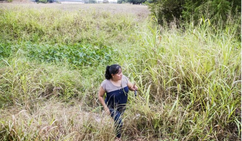
Lead image: Frances Acuña walks through a detention pond area designed to help protect her Austin, Texas, neighborhood from flooding. Credit: Austin American-Statesman/USA TODAY Network.
REFERENCES
Climigration Network. 2021. Lead with Listening: A Guidebook for Community Conversations on Climate Migration. https://www.climigration.org/guidebook.
FEMA NAC. 2020. “National Advisory Council Report to the Administrator.” November. Washington, DC: Federal Emergency Management Agency.
Kaplan, Sarah, and Andrew Ba Tran. 2022. “More Than 40 Percent of Americans Live in Counties Hit by Climate Disasters in 2021.” The Washington Post. January 5.
White House. 2021. “Report on the Impact of Climate Change on Migration.” October. Washington, DC: The White House.
Wing, Oliver E.J., and Paul D. Bates, Andrew M. Smith, Christopher C. Sampson, Kris A. Johnson, Joseph Fargione, and Philip Morefield. 2018. “Estimates of Current and Future Flood Risk in the Conterminous United States.” Environmental Research Letters 13(3). February.

Food systems have always been defined by uncertainty, from unpredictable weather to shifting consumer proclivities. But escalating threats such as climate change, resource depletion, and economic crises are presenting a bounty of new challenges to the global landscapes and systems that grow and provide our food. Over the coming year, six research projects commissioned by the Lincoln Institute will apply scenario planning to anticipate these forces and plan for their effects on various communities around the world, from Wisconsin to the West Bank.
The research projects were identified through a recent request for proposals issued by the Consortium for Scenario Planning, a program of the Lincoln Institute. The RFP invited proposals for research focused on several types of places: regions where external forces (such as climate change, the COVID-19 pandemic, or economic uncertainties) threaten the viability of agriculture; areas that support vital commercial agriculture; areas with a healthy or limited local food supply; communities that wish to encourage the growth of family or small-scale farming; or urban and rural areas that struggle with food accessibility.
“As climate change and economic instability have greater impacts on communities, food systems planning can be a key part of a community’s resilience,” said Heather Hannon, associate director of planning practice and scenario planning at the Lincoln Institute. “Planning for food systems in particular touches on many of the Lincoln Institute’s core initiatives, such as establishing resilient communities, addressing spatial inequality, sustainably managing land and water, and promoting fiscally healthy communities.”
“We are always looking for ways to stretch our scenario planning practice into new areas,” said Ryan Handy, policy analyst at the Lincoln Institute. “We hope this latest RFP cycle on food systems planning will introduce new models that other communities can use to address similar issues.”
The following research projects were selected by the Lincoln Institute:
All projects will be completed by June 2023. The Lincoln Institute issues an annual RFP for scenario planning projects; learn more about the projects selected in 2021, which focused on using scenario planning to advance climate strategies in communities, and those selected in 2020, which focused on equity and low-growth scenarios.
To learn more about all Lincoln Institute RFPs, fellowships, and research opportunities, visit the research and data section of our website.
Image: A farmer working in an olive grove in Aboud, a Palestinian village in the West Bank. Credit: Joel Carillet via E+/Getty Images.

In the increasingly urgent effort to curb greenhouse gas emissions and slow the damaging effects of climate change, local policy makers and planners are playing a critical role. The good news is, they have access to more data than ever. But wrangling, sorting through, and making sense of all this data can be a major challenge. A new crop of technological tools is helping to capture data related to municipal greenhouse gas emissions, organize it comprehensibly, and make it easy for municipal leaders to access.
In Minneapolis-St. Paul, the Twin Cities Metropolitan Council is working on an ambitious new effort to support local climate decisions. According to the Environmental Protection Agency, Minnesota’s emissions per capita as of 2016 were slightly above the national average of 16 metric tons of carbon dioxide per person. But breaking down the details behind that number can be complicated. Making it less complicated is a major goal of the council, which is a regional policy-making body, planning agency, and provider of essential services including transit and affordable housing for a seven-county region that includes 181 local governments.
In the works for about three years, and set for release this summer, the Metropolitan Council’s Greenhouse Gas Scenario Planning Tool grew out of the council’s work to promote regional livability, sustainability, and economic vitality, and is ultimately intended for use by any municipality in the United States.
Intriguingly, the process began by assembling a team of partners including several leading academics (from Princeton University, University of Texas at Austin, and the University of Minnesota) studying various aspects of climate change, as well as private-sector nonprofit partners—“giving us access to all the science and innovation that academia can bring, combined with the practical wisdom of government,” says Mauricio León, senior researcher for the Metropolitan Council.
León’s duties include greenhouse gas emissions accounting for the Twin Cities region, which makes him familiar with the complexities of both measuring emissions in the present and figuring out how to project that data into the future under different scenarios. The council’s recognition that this can be a time- and resource-consuming challenge for local governments led to the idea of building a web application that draws on existing databases and is adjustable according to specific policy strategies.
León and one of the council’s academic partners, Professor Anu Ramaswami—a civil and environmental engineering professor at Princeton who has been the principal investigator in the planning tool project—emphasized that such public/academic partnerships don’t happen often. “This is rare,” says Ramaswami, who has worked with individual cities for years, but seldom on a project meant to serve such a broad range of municipalities and local governments.
In terms of the process, she says, scientists and policy makers jointly framed the relevant questions, then built the model together. The collaborators identified data sets related to the primary sources of emissions. In the Twin Cities area, for example, 67 percent of direct emissions come from “stationary energy” such as the electricity and natural gas used to power homes and buildings, while 32 percent comes from on-road transportation. The team also identified the most promising reduction and offset strategies and policies, including regulations, economic incentives, public investments, and land uses such as parks and greenways. With three focus areas or modules—building energy, transportation, and green infrastructure—the application is designed to show policy makers the potential outcomes of various mitigation strategies. The overarching framework is pegged to the goal of local governments achieving zero emissions by 2040, an aspirational target adopted by the Metropolitan Council.
In a preliminary conceptual demonstration of the tool at the Lincoln Institute’s Consortium for Scenario Planning (CSP) conference earlier this year, León showed how different types of communities, from cities to rural areas, will have different impacts and strategy options. A city has a lot of transit options, for example, that a rural community doesn’t have. Policy makers using the tool can also factor in other key considerations, such as the equity implications of greenhouse gas reduction strategies that may impact some segments of a community more than others. “You can use this tool to create a portfolio of strategies that’s based on your values,” León explained.
With similar goals but a different approach, Boston’s Metropolitan Area Planning Council (MAPC) unveiled a localized greenhouse gas inventory tool several years ago. MAPC’s tool focuses less on future scenarios and more on providing community-specific, accurate baseline data and estimates of the impacts of various activities and sectors. Guided in part by a greenhouse-gas inventory framework developed by the World Resources Institute, C40 Cities, and ICLEI-Local Governments for Sustainability, it attempts to measure a municipality’s direct and indirect emissions.
Jillian Wilson-Martin, director of sustainability for Natick, Massachusetts, says the MAPC effort made available data and estimated impacts of car emissions, home heating, lawn care, and other factors that would be difficult for an individual town to collect. This helped Natick gauge its biggest sources of emissions, the starting point of a process to devise strategies to reduce them. Paired with offsets, the town aims to reduce its net emissions from 9 metric tons per capita to net zero by 2050. “It’s making it easier for smaller communities with no sustainability budget to get this really important data so they can be more effective,” Wilson-Martin says.
While MAPC provides guidance and training resources to the 101 cities and towns it serves in eastern Massachusetts, it’s up to leaders in each municipality to customize how they measure their local emissions inventory, and how they might use that for planning. This may limit specific forecasting uses, but has another payoff, says Tim Reardon, director of data services for MAPC. “Ultimately the value of having a nuanced and locally tailored tool is to gain credibility and buy-in with stakeholders at the local level,” Reardon explained at the CSP conference. While big-picture data that doesn’t apply to a particular community can be a turn-off, he said, local data brings the global climate crisis down to the ground and reduces a barrier to talking about what has to happen locally to ensure a resilient future.
Often in discussions around greenhouse-gas scenario planning, León agrees, “there’s this element of ‘this is just too complex for us to even think about.’” The council’s simple web tool is meant to help counter that argument. It’s designed to show in clear, graphic form the difference in emissions levels that would result from adopting various specific tactics, versus simply continuing the status quo.
One benefit of such an accessible tool, Ramaswami adds, is that it encourages wider involvement and thus “opens up more creative opportunities.” In fact, she says, the project has had a similar effect on its academic partners: “It requires a different kind of research mentality, and a different kind of research group” to work directly with municipalities and respond to real policy options. When the tool is released, it will be accompanied by the publication of related academic research from Ramaswami and the group’s other scholarly partners.
León acknowledges that the application will have its limits, and that ultimately more sweeping federal and global policies will have greater total impact than any single local initiative. But anything that boosts engagement is important, he says. And the web application is designed to encourage municipalities of all sizes to interact with the calculations and numbers the project team has compiled; they won’t have to upload their own data. “It’s really easy,” León says, “and there’s no excuse for them not to use it.”
Rob Walker is a journalist covering design, technology, and other subjects. He is the author of The Art of Noticing. His newsletter is at robwalker.substack.com.
Image: Leaders in Natick, Massachusetts, have used a greenhouse gas tool developed by Boston’s Metropolitan Area Planning Council to gauge the town’s largest sources of emissions. Credit: Denis Tangney Jr. via iStock/Getty Images Plus.

This article was originally published by the American Planning Association and is reprinted with their permission.
With 47 miles of coastline subject to punishing inundation, Boston is considering a range of innovative techniques to build resilience against the inevitable impacts of climate change. But one of the most groundbreaking features of this effort may well be the mechanism to pay for it.
City officials last year established a Climate Resiliency Fund to help finance the berms, seawalls, and natural systems restoration that will help protect real estate in the vulnerable Seaport district and other potential flooding hotspots. Private developers will make contributions to augment local, state, and federal funding.
The mechanism will be applied to the estimated $124 million cost of protecting a city-run, 191-acre coastal industrial park, but is poised to become a template for building resilience at many other vulnerable areas.
While chipping in to help build defenses seems to be an obvious thing to do, the resiliency fund reflects an important recognition: Public investments in critical infrastructure benefit the private sector by boosting property values—and in the case of rising seas, allow land to continue to be usable.
“There’s been a cultural shift,” said Brian Golden, who retired this spring as director of the Boston Planning and Development Agency after eight years of service. With such a huge task—preparing for 40 inches of sea level rise by 2070 across a landscape of hundreds of acres of squishy landfill dating back to colonial times—developers understand they have to pitch in and foot part of the bill, he said at the Lincoln Institute’s Journalists Forum in April.
“We don’t get a lot of people balking at any of this,” he added, suggesting that developers have come to understand exactions and charges for climate infrastructure as a basic reality of the times, and appreciate the consistency and predictability of the policy. “If you’re doing business with us . . . you’re going to be paying to build some resiliency measures.”
Don’t ‘Leave Money on the Table’
What’s happening in Boston reflects a growing consensus around the world, rooted in the concept of land value capture: the retrieval of increased land and property values specifically associated with government action and public investment. Just as a new transit line can increase values for properties all along it, resilience infrastructure can be shown to do the same. That increase in value is identified as the land value increment.
Allowing the private sector to enjoy those benefits without making any contribution is increasingly recognized as the equivalent of “leaving money on the table,” noted Enrique Silva, director of International Initiatives at the Lincoln Institute.
Value capture won’t fully finance climate adaptation efforts, but can become part of a “stack” of public finance arrangements that jurisdictions can leverage together, said Lourdes German, executive director of The Public Finance Initiative and a Lincoln Institute board member, also speaking at the Journalists Forum. Drawing contributions from developers and landowners can help fill critical gaps that often remain at the local level, after national and state funding is allocated.
The search for the necessary revenue to fight the battle against climate change, estimated by the UN to be some $90 trillion worldwide through 2030, is certain to intensify. Governments have been using versions of value capture in Brazil, Colombia, Ecuador, the United Kingdom, and throughout Asia for many years. Officials in Miami are studying similar mechanisms to help pay for resilience infrastructure in that flood-prone city.
Protecting Assets
The argument for developer contributions is bolstered by the quality of the climate action efforts, which build confidence that real estate assets on urban land will indeed be protected. Boston has been taking steady steps for decades to address climate change in its planning, backed up by changes to zoning regulations and its broad application of Article 80, which provides the discretion to approve projects with certain strings attached. The Climate Ready Boston plan won an APA award in 2019, and Singapore’s Lee Kuan Yew World City Prize bestowed special recognition for the city’s efforts to address climate change in an older coastal city.
It may have taken the climate crisis for landowners and developers to accept the obvious benefits of such government-funded interventions, said Golden. In the past, public investments that enhanced land and property values may have been regarded as a gift to the private sector or a form of stimulus for economic activity. Now the enormity of the task—fending off the water in some places, letting it be absorbed in others—is clear to all the stakeholders, who are more willing to be part of such a daunting, but necessary, effort.
“It’s an old city, our building stock is fundamentally 19th century and early 20th century, and none of this was considered,” said Golden, referring to climate impacts and flooding. “And it’s not just about the benefit to metropolitan Boston. We are, after all, the economic engine of all the New England states. So people are, in 2022, signing up for this. They get it.”
Anthony Flint is a senior fellow at the Lincoln Institute, host of the Land Matters podcast, and a contributing editor to Land Lines.
Image: Boston’s Seaport District. Credit: Denis Tangney Jr. via iStock/Getty Images Plus.

Several major sources of radical uncertainty are currently affecting the performance of infrastructure and will likely shape infrastructure in the future: climate change, automation, the sharing economy, and the COVID-19 pandemic. Our book, Infrastructure Economics and Policy: International Perspectives, recently published by the Lincoln Institute of Land Policy, attempts to determine how the infrastructure sector should cope with these radical uncertainties.
Three chapters of the book assess the impacts of climate change, automation, and the sharing economy, respectively, and discuss how public policies should respond to these challenges. The COVID-19 pandemic erupted while we were preparing the book, and little evidence was available on which to assess its impacts on infrastructure. These impacts are becoming increasingly clear now as data and empirical studies are emerging, and we have included our thoughts on them below.
Climate Change
Severe weather conditions and natural disasters due to climate change can seriously disrupt infrastructure services and damage or destroy infrastructure facilities, from transit lines to power lines. These impacts typically vary from one locality to another. For example, forest fires are a major concern in California, while rising sea levels are more important to Miami. As a result, Henry Lee, the author of chapter 18 of the book and a faculty member at the Harvard Kennedy School, argues that effective adaptation policies will mainly emerge at lower levels of government, in a bottom-up process.
Lee predicts that the magnitude of investments in climate-resilient infrastructure over the next few decades will be unprecedented. He discusses the characteristics of these investments and the scope of the transitions that will be required in the transportation, electricity, and water sectors. After identifying the governance challenges that underlie all climate mitigation and adaptation options, Lee proposes changes in governance to enable more effective planning, delivery, and management of infrastructure. His main messages are as follows:
Autonomous Vehicles
The second radical uncertainty examined in the book is automation and other new technologies that have emerged rapidly in recent years, thanks to advancements in information technologies such as cloud computing, the internet of things, and artificial intelligence. Whether these new technologies will revolutionize the infrastructure sector is the central question examined in chapter 19 by Shashi Verma, director of strategy and chief technology officer at Transport for London (TfL). Verma reminds us that fundamental infrastructure change typically comes only very slowly. Then, using autonomous vehicles (AV) as a case study, he discusses the economics of AVs, the likely impacts of automation on other modes and consumer behavior, and the institutional challenges it faces before its widespread acceptance. He offers the following advice:
The Sharing Economy
The third radical uncertainty examined in the book is the sharing economy. Sharing is an economic model of acquiring, providing, or sharing access to goods and services using online platforms. What impacts might the sharing economy have on infrastructure services and assets? In chapter 20, authors Andrew Salzberg and O.P. Agarwal explore this question using a case study of urban transportation. Salzberg is responsible for public policy at Transit, a leading public transportation app in North America, and before that worked as an executive at Uber. Agarwal served in the Indian Administrative Service and the World Bank and is currently chief executive officer of World Resources Institute India.
Over the last decade, new methods of sharing motor vehicles (Zipcar, Car2Go, Uber, Lyft, DiDi, Ola, and others) and smaller motorized electric vehicles like e-bikes and scooters (Bird, Lime, Gojek, etc.) have grown rapidly around the globe. Salzberg and Agarwal discuss the potential benefits, costs, and risks of shared vehicles, and argue that the sharing economy model has the potential to improve the use of fixed assets and thereby allow wider access to services. However, the current experience of shared vehicles in the U.S. indicates that the market penetration remains tiny, as most people still prefer individualized mobility services. Therefore, whether the service will grow to a significant size remains uncertain. The authors predict that new regulations will emerge to address the disruptive impact of this model on traditional businesses. More important, public policies related to road and parking pricing and congestion charges will be crucial to the future of the sharing economy in the urban transportation sector. Their chapter also delivers the following specific messages:
The COVID-19 Pandemic
During the production of the book, researchers were actively studying both the effects of infrastructure on pandemic severity as well as the effects of the pandemic on infrastructure. One of the first studies of the former appears in chapter 3, in which the World Bank’s Sameh Wahba, Somik Lall, and Hyunji Lee argue that infrastructure shortages and affordability challenges have exacerbated exposure and community contagion risk from COVID-19 across poor neighborhoods in developing cities around the world. Many other cities, including some of the major cities in China and Europe, adopted the opposite policy of attempting to reduce contagion by deliberately limiting access to infrastructure through lockdowns, quarantines, and other similar measures. How successful these measures have been in reducing the spread of disease and whether those reductions are worth their often-substantial economic costs is a matter of continuing and intense debate. Other emerging takeaways include:
Policy makers often assume that infrastructure investment would have significant multiplier effects on other parts of the economy. However, a review of empirical analyses of economic stimulus programs, presented in chapter 2—authored by Gregory Ingram (former president of the Lincoln Institute) and Zhi Liu—suggests that in developed economies, infrastructure spending has little stimulus effect in the first several years, after which the economy is likely to have begun growing again anyway. These analyses find little to no short-term economic impacts, even when the long-term economic impacts are clearly positive. The small short-term impacts are due in part to the substantial time required to prepare and construct a project and in part to the crowding out of private investment by public investment. Therefore, it is important to select and include the most valuable and shovel-ready projects in the stimulus programs.
José A. Gómez-Ibáñez is the Derek C. Bok Professor Emeritus of Urban Planning and Public Policy at Harvard University. Zhi Liu is senior fellow and director of the China Program at the Lincoln Institute of Land Policy.
Image: A woman in the back seat of a rideshare. Credit: halbergman via GettyImages.