El curso aborda las alternativas que existen para enfrentar el cambio climático desde la perspectiva de las políticas de suelo, con la utilización de instrumentos de planificación, gestión y financiamiento urbano. Los contenidos se presentan de acuerdo al ciclo de la política pública. Se hace énfasis en:
la relación entre urbanización y cambio climático (cómo identificar y definir los problemas climáticos);
planificación (cómo se pueden incorporar aspectos climáticos en la planificación urbana);
gestión y financiamiento (qué instrumentos de políticas de suelo se pueden utilizar para gestión y financiamiento climático); y
monitoreo y evaluación (cuáles son y por qué son importantes las metodologías para medir y monitorear avances).
El curso tiene cinco módulos con dos encuentros semanales, las cuales serán grabadas. Hacia el final del curso, los alumnos realizan un taller integrador donde pueden aplicar los conocimientos aprendidos.
Relevancia
La urbanización y las actividades humanas de las ciudades producen gases de efecto invernadero con impacto en la temperatura ambiente, las precipitaciones y la capa de hielo, lo que genera islas de calor, sequías, inundaciones y aumento del nivel del mar. Esto tiene consecuencias en la infraestructura urbana, la disponibilidad de recursos básicos, y provoca la pérdida de ecosistemas y desplazamientos masivos de población, entre otros impactos. A pesar de que las emisiones de gases totales de América Latina y el Caribe representan solo el 8,3% de las mundiales, la región es particularmente vulnerable al cambio climático debido a sus características (CEPAL, 2015). En este escenario, es urgente incrementar la resiliencia ante estos riesgos y reducir las emisiones de carbono de la región, especialmente a través de la implementación de políticas de suelo para la mitigación y adaptación climática.
Climate Mitigation, Environmental Planning, Legal Issues, Local Government, Planning, Public Policy
Urban Abundance
An Aerial Survey of Metro Boston Reveals a Regional Food System on the Rise
By Alex MacLean, June 23, 2021
SHARE
Across four decades as an aerial photographer, I have been drawn to documenting agriculture for the way it reveals important clues about region, climate, topography, soil, and the passage of seasons and time. This work has increasingly focused on the connections between land use and climate change, as attention to shortening food miles—reducing the distance between producers and consumers, with the goal of lowering carbon emissions and minimizing supply chain disruptions—visibly plays out across rural–urban transects. The images in these pages represent the first steps in an inquiry into how food production in and around urban areas in the United States is changing.
In recent years, the intensification of small-scale growing in the region around Boston, Massachusetts, has been increasingly apparent. From the air, I’ve seen hoop houses spring up on small farms seeking to meet demand and expand productivity; I’ve seen drab commercial and residential rooftops become vibrant gardens; I’ve seen historically nonproductive urban land like vacant lots and lawns become cultivated spaces. When added up, these small-scale operations seem to hold real potential for productivity gains through the power of increments. Green spaces in and near urban areas don’t just provide people with fresher, more accessible food; by filtering stormwater, absorbing carbon dioxide, and providing other environmental benefits, they can also make cities healthier, more resilient places.
Despite these promising changes, what is commonly understood as the locavore movement has done more to create a sense of place, build community, and educate around food than it has to increase food security or shorten food miles at the scale necessary to confront climate change. While demand and enthusiasm for local food has grown over the last decade, an estimated 90 percent of food in the Boston metro area comes from outside the region, according to Food Solutions New England (FSNE), a regional network based at the nearby University of New Hampshire. But policy makers, investors, farmers, and entrepreneurs in the area are working to change that, and FSNE is advocating for “50 by 60”—referring to the percentage of food that could be regionally sourced by 2060.
One trend that could help reach that goal, also visible from the air, is indoor farming. Most commonly located in undervalued industrial neighborhoods, indoor farms use technologies like hydroponics and LED lighting to enable year-round cultivation. The companies behind them are increasingly demonstrating that a lack of open space does not have to be a constraint on food production. The indoor farming industry attracted $1.9 billion in global venture capital in 2020, three times the amount committed in 2019.
Boston is home to some of the companies gaining the most momentum. Freight Farms, for instance, further democratizes proximity to production through the use of retrofitted shipping containers that can be tucked beneath elevated highways or squat next to school cafeterias. In 320 square feet, these containers yield as much produce as two cultivated acres. Such innovative solutions give insight into what alternative growing can look like as climate change degrades farmland and shrinks water supplies. However, indoor farming has its drawbacks; it can be energy intensive and, although its yields are often marketed as “local,” in some senses it replicates the centralization and corporate influence against which local and regional agriculture advocates have long chafed.
As an aerial photographer, I hope some form of outdoor food production will always be integrated into our landscapes. Whether viewed from the ground or from the air, farms and fields help us understand the key elements of the natural world that sustain us, providing a connection to the planet and an impetus to protect these places. But from above, it is increasingly apparent that a reimagining of agricultural systems is underway, and that we will need many different approaches for “local food” to evolve into an equitable model of regional food sovereignty.
The Boston metro region imports 90 percent of its food from outside the region. Above, box trucks and refrigerated trailer units line the New England Produce Center warehouses in Chelsea, just north of downtown Boston. Among the largest wholesale produce markets in the world, the complex receives shipments from across the United States and internationally. Produce is then redistributed to food outlets throughout New England and southeastern Canada. Credit: Alex MacLean.
The renowned Fenway Victory Gardens along the Muddy River in Boston’s Back Bay are made up of over 500 plots that remain on land that was dedicated to food production during World War II. Fenway was one of over 20 million victory gardens across the country that contributed to growing roughly 40 percent of the nation’s produce at the height of the war. The history speaks to the potential to adapt and to grow local produce on a large scale. Credit: Alex MacLean.
The community garden at the First Parish Church in Lincoln, Massachusetts, seen in four seasons. Changes in the garden throughout the year are a time marker that affirms our awareness as we transition through seasons. Parishioners grow individual plots and collectively grow a donation plot that provides an average of 600 pounds of food each year to Boston-area homeless shelters and soup kitchens. Credit: Alex MacLean.
The Largest of Mill City Grows’ four farms, “Big Farm” is situated on 2.8 acres leased from the city of Lowell, Massachusetts. The food from these farms is distributed through mobile markets, a Community Supported Agriculture farm share program, and donations. In working toward local food justice, Mill City Grows also partners with schools to support educational and community growing initiatives. Credit: Alex MacLean.
The city of Lawrence, Massachusetts, helped establish the Cross and Cedar Street Garden in 2011. The garden, which is tended by local residents, occupies two vacant lots where dilapidated housing had been torn down. Raised beds help protect against the hazards of contaminated soil. Credit: Alex MacLean.
The Nightingale Community Garden in Dorchester, Massachusetts, owned by statewide conservation organization The Trustees, is part of a citywide initiative to increase access to local produce, and to make community gardens a prominent feature of unbuilt urban spaces. Credit: Alex MacLean.
Planted terraces on top of The Esplanade, a condominium complex in Cambridge, Massachusetts, demonstrate the potential for commercial roof spaces to accommodate urban agriculture. Credit: Alex MacLean.
Chicken tractors and containment pens are moved each day at Codman Community Farms in Lincoln, Massachusetts, one of the sustainable practices that goes into producing 800 to 1200 eggs per week. Located 15 miles northwest of Boston and dating back to 1754, the farm sits on 18 acres. An additional 120 acres of fields and pastures scattered throughout the town provide hay for livestock and open spaces for those living in the surrounding area. Credit: Alex MacLean.
Over 95 percent of greens consumed on the East Coast come from California and Arizona, often spending over a week in transit. Little Leaf Farms is working to disrupt reliance on West Coast produce through year-round hydroponic growing in a 10-acre greenhouse in Devens, Massachusetts, 40 miles west of Boston. The growing process is entirely automated; greens are planted and harvested without touching human hands. The company’s success thus far has brought in $90 million in debt and equity financing to expand operations down the East Coast, beginning in Pennsylvania and North Carolina. Credit: Alex MacLean.
Freight Farms manufactures vertical hydroponic greenhouses inside 40-foot shipping containers. Equipped with precise climate control and optimized lighting for select plants, the containers can yield up to two acres of conventionally grown produce in 320 square feet. The mobile greenhouses can be placed anywhere, such as beneath highway underpasses or adjacent to schools. Credit: Alex MacLean.
Built on what was once a contaminated brownfield site in Providence, Rhode Island, Gotham Greens—the white structure at bottom left of image—provides New England with year-round hydroponically grown greens and herbs. The greenhouse is powered by renewable electricity and uses 95 percent less water and 97 percent less land than conventional agriculture. Credit: Alex MacLean.
Gaining Ground Farm in Concord, Massachusetts, grows produce for Boston-area shelters and food pantries. Using high tunnels, hoop houses, row covers, and soil nourishment, Gaining Ground has increased production by over 100 percent over a four-year period. In 2020, Gaining Ground grew and donated 127,429 pounds of produce, compared to 61,764 in 2016. This photograph, taken in 2016, shows the farm’s early adoption of hoop houses. Credit: Alex MacLean.
This photograph, taken in 2020, shows the intensification of production at Gaining Ground Farm in Concord, Massachusetts. Gaining Ground, which grows produce for Boston-area shelters and food pantries, more than doubled the amount of food it grew and donated between 2016 and 2020. Credit: Alex MacLean.
This community garden in Allston-Brighton, Massachusetts, is on land owned by the state Department of Conservation and Recreation. The mid-October foliage foretells the end of the growing season and the onset of winter. Credit: Alex MacLean.
Alex MacLean is a pilot and internationally exhibited photographer whose work has appeared in Land Lines and the Lincoln Institute book Visualizing Density. He specializes in documenting changes to the land brought about by human intervention and natural processes.
Lead Image: Boston’s community gardens have created a stronger sense of place within city neighborhoods. The Worcester Street Community Garden in Boston’s South End is one of 56 community gardens owned by The Trustees. Managed by volunteers, the Worcester Street garden has more than 130 plots available to Boston residents on a first-come, first-served basis. Credit: Alex MacLean.
Tackling Climate Change: The Not-So-Hidden Role of Land (A 75th Anniversary Lincoln Institute Dialogue)
June 23, 2021 | 12:00 p.m. - 1:00 p.m.
Free, offered in English
Speakers: Sivan Kartha, Michelle Manion, and Amy Cotter
SHARE
Watch the Recording
Watch the Recording
Land and water policy have the potential to shape the built and natural environment to reduce energy demand, remove greenhouse gases from the atmosphere, and help communities and natural systems thrive as the climate changes. Daily decisions about the use, taxation, and stewardship of land are opportunities to advance both climate mitigation and resilience in ways that enhance quality of life and place. Dr. Sivan Kartha of the Stockholm Environment Institute and Michelle Manion of Mass Audubon join Amy Cotter of the Lincoln Institute of Land Policy to discuss how land policy, from local to global scales, is essential to meeting climate goals.
Speakers
Dr. Sivan Kartha is a senior scientist at the Stockholm Environment Institute whose research and publications for the past 25 years have dealt with policy strategies for addressing climate change, focusing on equity and effectiveness in the design of an international climate regime. Dr. Kartha has also worked on mitigation scenarios, market mechanisms for climate actions, and the environmental and socioeconomic impacts of biomass energy.
Michelle Manion is vice president of policy and advocacy for Mass Audubon. Trained as an economist and in public policy and natural resources, she has over 20 years of experience advocating at the state, federal, and international level for effective, workable solutions to mitigate climate change, protect biodiversity, and create sustainable natural systems.
Amy Cotter is director of climate strategies for the Lincoln Institute of Land Policy. An urban planner by background, she has more than 25 years of experience developing and implementing land policy to promote equity and sustainability. She oversees the Lincoln Institute’s research, education and practice related to climate change, planning practice, and scenario planning.
Details
Date
June 23, 2021
Time
12:00 p.m. - 1:00 p.m.
Language
English
Registration Fee
Free
Cost
Free
Preguntas a expertos
Concebir la resiliencia ante el cambio climático
January 12, 2021
SHARE
Expertos de la red del Instituto Lincoln responden a la pregunta: Si en 2021 pudiera implementar una solución basada en el suelo que tenga un impacto considerable en el cambio climático, ¿cuál sería?
Cortesía de Robin Bronen.
Robin Bronen
Directora ejecutiva del Instituto para la Justicia de Alaska; miembro del Comité Director de Climigration Network
Devolver las tierras robadas a los pueblos originarios y eliminar las fronteras y los límites que dividen y separan los ecosistemas de los cuales dependemos. Los pueblos originarios conservan la biodiversidad del planeta desde hace milenios. El 25 por ciento del suelo que ellos ocupan en el planeta coincide con el 40 por ciento de las zonas naturales protegidas y los territorios que aún no están dañados. Según los estudios realizados por el Banco Mundial, estos territorios albergan el 80 por ciento de la biodiversidad del planeta. En los Estados Unidos, el colonialismo de asentamientos creó estructuras legales e institucionales que echaron y reubicaron por la fuerza a poblaciones originarias de sus tierras tradicionales y reestructuraron sus tierras como propiedad y como recurso. La repatriación de estas tierras a los pueblos originarios, en su calidad de administradores de estas tierras que hoy se denominan Estados Unidos, ayudaría a rectificar esta injusticia. Al eliminar la construcción social de las fronteras y los límites que dividen el suelo de forma artificial y quitar esas líneas invisibles, los ecosistemas y la biodiversidad de los cuales depende la humanidad podrían prosperar al mismo tiempo que la crisis climática transforma la red de la vida.
Cortesía de la Sociedad Estadounidense de Arquitectos Paisajistas.
Kongjian Yu
Fundador y presidente de Turenscape; colaborador de Nature and Cities
La solución más efectiva y holística para el cambio climático son los “suelos esponja”. Esta solución basada en el suelo expande el concepto de “ciudades esponja”, que usa infraestructura verde para absorber agua pluvial y combatir la contaminación en zonas urbanas. Con ella, se puede retener agua de lluvia en la fuente, detener su curso cuando fluye y usarse de forma flexible en su salida (ya sea un río, lago u océano). Esta alternativa es totalmente opuesta a las soluciones convencionales de ingeniería de uso extendido en todo el planeta, en particular en países en vías de desarrollo con monzones: hacer diques en los ríos para crear grandes embalses, canalizar agua con muros antiinundación de concreto, construir drenajes de concreto en la ciudad y bombear el agua hacia afuera. La infraestructura gris consume grandes cantidades de cemento y crea grandes cantidades de emisiones de carbono, sofoca los ecosistemas más productivos con la mayor biodiversidad y los hacen menos resilientes.
Los suelos esponja consisten en la generación de porosidad en paisajes vastos y montañosos que sufren erosión; la creación de “campos esponja” en forma de estanquecitos en tierras agrícolas donde la escorrentía contamina los ríos y lagos cercanos; y la creación de ciudades esponja. El concepto de suelo esponja significa usar con prudencia el cemento para ingeniería hidrológica y el pavimento en zonas urbanas. También significa quitar los muros antiinundación de concreto y los diques de vías fluviales para restaurar el hábitat, reabastecer agua subterránea, obtener vegetación frondosa y promover otros beneficios. Los suelos esponja son una solución eficiente y poco costosa que fortalecerá la capacidad de resistencia del suelo ante el cambio climático.
Cortesía de la Universidad Cornell.
Linda Shi
Profesora adjunta de Planificación Regional y de Ciudades, Universidad Cornell; disertante de la beca a la investigación C. Lowell Harriss entre 2015 y 2016
Los Estados Unidos necesitan un plan nacional de adaptación climática que incluya una estrategia de uso y desarrollo del suelo. Las labores relacionadas con la eliminación del dióxido de carbono y las energías renovables, como biocombustibles y paneles solares, tendrán un gran impacto en el uso del suelo rural. Si no se logra descarbonizar, se escalarán los impactos climáticos, la migración causada por el clima y los nuevos entornos de injusticias en forma de oasis climáticos y asentamientos informales. El creciente conflicto político urbano y rural ya refleja las desigualdades espaciales y socioeconómicas, cuyas raíces son la extracción de recursos y personas rurales para los procesos de urbanización, dinámicas que la crisis climática puede exacerbar. Las respuestas del mercado no serán suficientes a escala, no apuntarán a geografías que puedan admitir crecimiento de forma sostenible ni permitirán una transición climática justa. Por lo tanto, la magnitud de las acciones necesarias para afrontar la crisis climática exige una nueva arquitectura nacional de políticas de suelo. Esto incluye: (1) identificación de geografías, con base en la ciencia y en la igualdad, donde se deban aplicar el crecimiento y las inversiones del futuro; (2) políticas fiscales, de inversión y de subsidios que permitan a los gobiernos locales responder a los efectos del cambio climático, en vez de cargarlos con mandatos sin financiamiento o medidas punitivas; y (3) reformas legales a regulaciones bancarias y organizativas que expandan los modelos de posesión cooperativa y ayuden a aumentar el control comunitario de las viviendas y el suelo para retener y crear riquezas locales.
La zonificación de los barrios periféricos de los Estados Unidos propició un entorno suburbano dominado por casas unifamiliares grandes en lotes extensos, y amplias zonas (que suelen estar vacantes) de uso industrial y de oficinas. Así, se promovió un patrón autodependiente de población y centros de empleo muy dispersos que, a su vez, ocasionó mayores emisiones por viajes en vehículo, además de uso de energía para iluminación, calefacción y refrigeración. También restringió la construcción de viviendas, exacerbó los problemas de capacidad de pago y causó que millones de trabajadores de ingresos más bajos hicieran viajes largos todos los días para ir de los centros urbanos a su empleo en los suburbios. Las soluciones son directas y no requieren que se deshaga la zonificación de viviendas unifamiliares. Los estatutos de zonificación de los estados deberían exigir a los municipios que admitan departamentos y estructuras complementarios en zonas de viviendas unifamiliares siempre que sea posible desde un punto de vista de salud y seguridad; permitan viviendas multifamiliares en corredores comerciales y en zonas industriales o de oficinas; y rezonifiquen predios vacantes que fueron salteados para viviendas multifamiliares (en casi todos los suburbios del país hay decenas de ellos). Una mayor densidad residencial en corredores y núcleos de uso mixto, a su vez, aumentará en gran medida las oportunidades para soluciones de transporte eficientes y rentables. Ampliar y diversificar las opciones de vivienda en suburbios que ya están muy desarrollados es responder a necesidades de vivienda insatisfechas y reducir la presión para que los subterráneos se expandan hacia afuera. De esta manera, los suburbios en sí serán más sostenibles ante cambios demográficos, ante la demanda de viviendas y ante futuros impactos climáticos.
Cortesía de Sivan Kartha.
Sivan Kartha
Científico sénior en el Instituto Ambiental de Estocolmo; asesor en el programa climático del Instituto Lincoln
En una encuesta a 64 países, se calculó que los bosques que pertenecen a pueblos originarios y comunidades forestales en conjunto contienen el equivalente a alrededor de un billón de toneladas de dióxido de carbono, lo cual equivale a más de tres décadas de emisiones por uso de combustibles fósiles en todo el mundo. Además, estas tierras son de las más ricas en biodiversidad y albergan recursos vitales de agua potable. Sin embargo, los derechos territoriales de quienes viven en esos bosques no suelen estar reconocidos formalmente. Los países con abundantes bosques suelen tener legados colonialistas: las tierras y los recursos se tomaron por la fuerza en detrimento de las comunidades locales. Aún se conservan derechos a la propiedad seculares y regímenes de tenencia de suelo que, originalmente, se establecieron para fines impositivos y de extracción, lo que acrecentó el deterioro constante de los recursos de los bosques. Cada vez más investigaciones demuestran que, cuando los derechos territoriales se reconocen formalmente y se salvaguardan por medios legales, los pueblos originarios y las comunidades locales pueden proteger recursos comunes mediante prácticas informales y acciones colectivas que evitan la deforestación, preservan la biodiversidad y protegen servicios de ecosistemas, como enriquecimiento del suelo y salud de las cuencas. Por el contrario, si se imponen regímenes convencionales de propiedad privada, pueden surgir nuevos problemas, se dispara la especulación territorial y se desafían las normas culturales locales. Al establecer derechos de tenencia territorial seguros para los pueblos originarios y las comunidades rurales, se podrían preservar mejor los recursos de los bosques del mundo, que se están reduciendo. A la vez, se podría salvaguardar el sustento del cual dependen cientos de millones de residentes.
Cortesía de Tamika Butler.
Tamika Butler
Asesora de entornos construidos e igualdad en TLB Consulting; oradora invitada en el Instituto de Planificadores de Grandes Ciudades
Para 2021, lo que anhelo es que el aumento de atención, debates y asignación de recursos con relación a la lucha contra el racismo, la supremacía blanca y los movimientos antinegros no desaparezcan con el cambio de año y con el esfuerzo de la gente por “volver a la normalidad”. No debería alcanzar con solo estar mejor de cómo estamos ahora. Como persona negra, con solo ver las estadísticas sabría que la antigua normalidad implicaba que mi vida era prescindible. Como persona negra, también sé que en esta nueva normalidad, con solo ver cualquier estadística sobre COVID-19, crímenes de odio o racismo medioambiental, sabría que mi vida sigue siendo prescindible. Además de que no alcanza, “volver a la normalidad” no tendrá un impacto significativo sobre el cambio climático. Por el contrario, anhelo que quienes están en el poder examinen a quiénes están oyendo y financiando cuando se trata de soluciones basadas en el suelo.
Las ideas, soluciones e indagaciones para combatir el cambio climático con soluciones basadas en el suelo deberían centrarse en procurar que escuchemos a las personas negras, representantes de pueblos originarios y otras personas racializadas y miembros de grupos históricamente oprimidos que desde hace mucho lideran el cambio climático, la sustentabilidad y la lucha por proteger a la humanidad. Todas las soluciones para el cambio climático deberían centrarse en la idea de que en 2021 debemos dejar de matar a la gente negra, de pueblos originarios, y a otras personas de color.
Implementar cargos por desarrollo con componentes medioambientales podría tener un impacto considerable en el cambio climático. Se trata de permisos urbanos o de construcción que tienen en cuenta aspectos hídricos y de vegetación para ejercer derechos básicos o adicionales de construcción. Para ilustrar el último caso, añadir suelo para espacios urbanos verdes a cambio de un aumento de densidad podría ser un cargo adicional. Estas herramientas de planeamiento urbano podrían financiar la adaptación y la mitigación ante el cambio climático porque podrían generar recursos a nivel local para financiar la conservación o implementación de infraestructura verde y azul en espacios públicos y privados. Se priorizarían las soluciones basadas en la naturaleza. La naturaleza puede ofrecer soluciones más asequibles a largo plazo y más beneficiosas para humanos y ciudades que las que solo usan infraestructura gris. Al mismo tiempo, dichas soluciones pueden funcionar como medidas de mitigación y adaptación.
En general, estos requisitos se deberían aplicar en el mismo lugar donde se construye, en forma de drenaje sostenible, reforestación o espacios verdes. En casos excepcionales, implicarían financiar infraestructura verde en otro lugar. Se pueden adjuntar condiciones medioambientales a derechos de construcción de distintas formas, según los efectos locales del cambio climático y la magnitud del proyecto de desarrollo urbano. El planeamiento urbano, la ley y la regulación de la propiedad privada tienen una función importante frente al cambio climático.
Cortesía de la Universidad de Pensilvania.
Frederick Steiner
Decano en la Facultad de Diseño Stuart Weitzman de la Universidad de Pensilvania; coeditor de Design with Nature Now
Mientras trabajamos para promulgar políticas efectivas, debemos cambiar el modo de sentir y pensar el cambio climático y adaptar nuestro estilo de vida en consecuencia. Cualquier persona que lea esto debería hacer una lista con 365 actividades personales que afectan el cambio climático y comprometerse a reemplazar una por día con una acción que mitigue el cambio climático o se adapte a él. Si comparten la promesa en redes sociales, podrían alentar a familiares, amigos y seguidores a hacer lo mismo. Todas estas acciones se vinculan con el suelo, el agua y la energía. Por ejemplo:
usar una fotocopiadoraplantar un árbol construir un patiohacer un jardín conducir un automóvilsalir a caminar quejarse de los políticosllamar y escribir a representantes encargar un libro en líneavisitar una librería local comprar productos agrícolas importadoscultivar un tomate llevar ropa a la lavanderíaaprender a planchar asar carnecomer un grillo ir en avión a una conferenciaorganizar un evento por Zoom encender el aire acondicionadoabrir una ventana cortar el céspedplantar flores nativas actualizar el plan del cableobservar aves
y así durante 353 días más.
Cortesía de IGC.
Astrid R. N. Haas
Directora de políticas en el Centro Internacional de Crecimiento
Desde una perspectiva gubernamental, implementar soluciones basadas en el suelo en mi país, Uganda, es un desafío en sí mismo. Esto se debe, en parte, a que la Constitución y todos los instrumentos legislativos subsiguientes relativos al suelo indefectiblemente otorgan el suelo a la gente. Además, Uganda tiene varios sistemas de tenencia coexistentes, y a la vez escasa capacidad administrativa para delinear cada uno de ellos o documentar la posesión. Esta situación limita la capacidad del gobierno de implementar soluciones basadas en el suelo que destraben el valor público. Por lo tanto, es en este contexto que en 2021 yo pensaría en el reajuste de suelo como en un enfoque totalmente práctico y la solución basada en el suelo más viable. En particular en zonas urbanas, esta herramienta tiene un potencial enorme [se trata de un modelo en que los propietarios reúnen sus propiedades para concretar un proyecto de redesarrollo]. Por ejemplo, al trabajar a nivel local, se podría determinar la tenencia y la propiedad del suelo y lograr que la comunidad adquiera predios agrupados para ejecutar desarrollos de mayor densidad. Hay cada vez más evidencia de que las ciudades con mayor densidad son más ecológicas y más eficientes con respecto al cambio climático. Por lo tanto, esta solución tendría un impacto importante no solo en la eficacia del modo en que se pueden gestionar las ciudades de Uganda (en particular en lo que respecta a proveer servicios públicos), sino también en el cambio climático.
Cortesía de IAAO.
Larry Clark
Director de iniciativas estratégicas en la Asociación Internacional de Funcionarios Tasadores
Soy un valuador con 40 años de experiencia en tres jurisdicciones locales; escribo artículos, doy conferencias y enseño valuación masiva en muchas partes de los Estados Unidos y el mundo. Gracias a mi vínculo con personas de todas partes del mundo, logré entender los problemas que conlleva el cambio climático. Una de las realidades es que los recursos hídricos están mal distribuidos en los 50 estados. El cambio climático exacerba esa situación porque provoca sequías en una parte del país, y en otra el aumento de temperatura provoca lluvias intensas e inundaciones. Por lo tanto, mi deseo sería desarrollar una red nacional de embalses y sistemas de distribución para recolectar y redistribuir las precipitaciones en todo el país. Se requeriría un esfuerzo de alcance similar al sistema federal de autopistas que comenzó con el presidente Eisenhower, que debería regir un organismo regulador que priorice las necesidades humanitarias por sobre las agrícolas y comerciales. Los sistemas de recolección deberían ubicarse en las zonas inundables actuales y previstas para el futuro, así como en las de escorrentía natural, para que el agua rellene embalses y luego se distribuya a sistemas hídricos municipales que la necesiten.
Cortesía de la Universidad Texas A&M.
Forster Ndubisi
Profesor de arquitectura paisajística y planeamiento urbano en la Universidad Texas A&M; autor de Ecology in Urban Design and Planning
Las soluciones ante el cambio climático exigen que volvamos a pensar los fundamentos de nuestras relaciones éticas con el suelo. Propongo que iniciemos el proceso de reflexión crítica sobre nuestras obligaciones éticas para con el suelo y en 2021 adoptemos la ética ecocéntrica con base en el lugar (PBEE, por su sigla en inglés) como una solución para el cambio climático. La adopción de la PBEE mediante educación de inmerión a largo plazo estipula la conducta ética y las obligaciones morales que deberían adoptar diseñadores y planificadores al abordar los desafíos del cambio climático. La PBEE se basa en la interdependencia entre la gente y los procesos biofísicos [de la naturaleza], que plantea una dependencia mutua entre ambos componentes para que puedan seguir existiendo. El resultado indefectible de la interacción humana con los procesos naturales es cierto deterioro de los recursos y procesos naturales [capital natural], como paisajes que ofrecen servicios vitales de ecosistemas. Por lógica, la PBEE establece el mandato moral de preservar el capital natural cuando sea posible; conservarlo cuando se demuestre un grado justificable de uso; reabastecerlo mediante restauración natural de ecosistemas deteriorados; minimizar el alcance de la huella humana; reducir el uso de carbono y adoptar de forma activa la administración medioambiental. Para combatir el cambio climático con eficacia, la PBEE utiliza los conocimientos ecológicos como un proceso para comprender la interdependencia entre el ecosistema humano y el natural. A su vez, los conocimientos ecológicos funcionan mejor si se usa un proceso de ideas que considere los sistemas y el diseño, y si se colabora de forma participativa para crear soluciones que mitiguen el cambio climático y se adapten a él.
Teniendo en cuenta los impactos socioeconómicos de la pandemia de COVID-19, se necesitan soluciones tanto locales como metropolitanas para prevenir impactos no deseados en el medioambiente, como la contaminación, la acumulación de basura y la reducción de áreas verdes. Las ciudades deben tener conectividad, pensamiento sistémico y sostenibilidad metropolitana. Las ciudades deben implementar tanto una economía circular como una tributación circular, para fortalecer los impuestos inmobiliarios y ambientales, y permitir respuestas locales más rápidas, efectivas y eficientes. Estos sistemas también pueden propiciar una reducción de la corrupción, una mejor calidad de vida y la mitigación de los cambios climáticos. Con el objetivo de lograrlo, proponemos un impuesto circular, una herramienta fiscal inteligente para la construcción y el desarrollo de ciudades y regiones metropolitanas. Esto implica el fortalecimiento de la tributación inmobiliaria (impuesto predial, tributación diferenciada por uso y ubicación, impuesto a las mejoras) y de los impuestos ambientales (tasas de recolección y reciclaje de basura, impuesto sobre amenazas ambientales metropolitanas, aplicación del principio de quien contamina paga). Un impuesto circular fortalecería la planificación y la gestión urbana sostenible y es una política territorial que puede ayudar a preservar el medioambiente.
Fotografía: Vista aérea de una central solar en Alemania. Crédito: Bim/Getty Images.
Consortium Announces Winners of RFP Focused on Climate Strategies
By Emma Zehner, May 24, 2021
SHARE
What happens to the land left behind when a community retreats from rising seas? Over the next year, Kelly Main, executive director of the nonprofit Buy-In Community Planning, will use scenario planning to research and consider how land acquired through buyouts might be converted into open spaces and serve conservation and stormwater management goals. Main’s project, which will use data on buyout properties held by the New York State Governor’s Office of Storm Recovery, is one of seven recently selected for support by the Lincoln Institute of Land Policy. The projects will develop new applications of scenario planning that advance climate mitigation and adaptation strategies in communities.
Awardees—who range from practitioners to academics—have been selected to receive a combined $90,000 to conduct original research and develop tools that specifically use exploratory scenario planning, a type of scenario planning that considers a range of possible futures to inform decisions. The funded projects, scheduled for completion by April 2022, will range in format from an interactive exercise to how-to guides.
“The goal of this RFP is to use land policy to reduce the most catastrophic effects of climate change and help cities adapt to the impacts that remain avoidable,” Heather Sauceda Hannon, associate director of planning practice and scenario planning at the Lincoln Institute, said. “As a structured approach to participatory and evidence-based decision making, scenario planning can help cities and regions prepare and plan for uncertain climate futures.”
The Lincoln Institute will also support the following projects:
Ray Quay, research professional at the Decision Center for a Desert City at Arizona State University, will develop an exploratory scenario planning exercise to inform decision makers about the dynamics of land and water management practices, and of water sustainability. Quay will also receive support from the Lincoln Institute’s Babbitt Center for Land and Water Policy.
Andrew Rumbach, associate professor of landscape architecture and urban planning at Texas A&M University, will explore how small towns and rural places can use exploratory scenario planning to plan for climate change adaptation.
Focusing on older industrial cities in northeast Ohio and western New York State, Terry Schwarz, director of the Cleveland Urban Design Collaborative at Kent State University, will compile a how-to guide for making climate-responsive decisions.
Using Belo Horizonte, Brazil, as a case study, Nilo Nascimento, professor at the Federal University of Minas Gerais in Brazil, will research the challenges of adapting green and blue infrastructure to urban flood mitigation, using different scenarios of extreme rainfall events.
Ryan Thomas, a Ph.D. candidate in city and regional planning at Cornell University, will study how planners and consultants are using climate scenarios in New York State and attempt to draw broader lessons about how local climate scenarios could be coordinated in a large region.
Donovan Finn, assistant professor of environmental design, planning, and policy at Stony Brook University, will write a guide for planners to use qualitative tools such as story boards to better communicate the science of climate and integrate it science into the planning process.
The projects are supported by the Lincoln Institute’s Consortium for Scenario Planning. The Consortium aims to improve the practice of scenario planning and broaden its use across disciplines in communities of all sizes through research, peer-to-peer learning, training, and technical assistance.
Phoenix es la quinta ciudad más grande y la metrópolis con mayor índice de crecimiento de los Estados Unidos. Kate Gallego es la segunda alcaldesa mujer electa en la historia de Phoenix; y, con sus 39 años, es la alcaldesa de una ciudad importante más joven del país. Según ella, orientar este crecimiento implica priorizar la diversidad económica, las inversiones en infraestructura y la sustentabilidad. Cuando estaba en el ayuntamiento de Phoenix, dirigió la campaña para aprobar un plan de transporte en toda la ciudad que se prolonga hasta 2050. Cuando este se aprobó, en 2015, fue el acuerdo más grande del país de un gobierno local sobre infraestructura de transporte. Antes de dedicarse a la política, Gallego trabajó en desarrollo económico para Salt River Project, un servicio público de agua y electricidad sin fines de lucro que atiende a más de dos millones de personas en el centro de Arizona. Poco después de haber sido electa por segunda vez, la alcaldesa Gallego habló con Anthony Flint, nuestro miembro sénior. Fue la primera de una serie de entrevistas por el 75.º aniversario con alcaldes de ciudades que tienen una importancia especial para el Instituto Lincoln. A continuación, se presenta la transcripción editada de la conversación.
Anthony Flint: La felicito por la reelección. ¿Cuáles cree que son los temas que más motivaron al electorado en estos tiempos turbulentos?
Kate Gallego: El electorado buscaba candidatos que pudieran liderar en función de datos reales y tomar decisiones basadas en la ciencia. Yo llego a este puesto con un historial en desarrollo económico y un título de grado en medioambiente. El profesor de química nos decía que cuantos más cursos de química hiciéramos, más lejos estaríamos de avanzar en política electoral. Pero creo que el 2020 puede haber sido un año distinto: la ciencia fue importante para el electorado . . . El electorado de Arizona quería dirigentes que se tomaran la COVID-19 en serio, al igual que otros desafíos como el cambio climático y la recuperación económica.
Particularmente para el sector más joven, el cambio climático era un asunto muy importante. Me postulé cuando la comunidad sufría el verano más caluroso que se hubiera registrado. Puede que en algunas comunidades el cambio climático sea un tema del futuro, pero en Phoenix es un problema al que nos enfrentamos ahora. Las distintas generaciones lo describen de distintas formas. Mi papá me dice: si puedes hacer algo para aliviar el calor que sentimos durante el verano aquí, seguro saldrás reelecta. Es otra visión, pero creo que el resultado es el mismo.
AF: ¿Cómo afectó la pandemia a las labores de planeamiento urbano? ¿Surgieron oportunidades imprevistas?
KG: La pandemia realmente cambió el modo en que la gente interactúa con su comunidad. Aumentaron los paseos en bicicleta y a pie. Lo que la gente nos dice es que antes no se daba cuenta de cuánto disfrutaba esa forma de moverse en la comunidad, y pretende mantener algunos de esos cambios de conducta . . . Estamos evaluando cómo podemos crear más espacios públicos. ¿Podemos expandir la gastronomía al aire libre y permitir a la gente interactuar más entre sí?
El Dr. Anthony Fauci nos dijo que cuanto más tiempo pasemos al aire libre mejor combatiremos la COVID-19. Pero hay otros beneficios muy buenos. Soy la alcaldesa de la ciudad con mayor superficie de parques en todo el país, y este fue un año récord en que se disfrutaron esos parques . . . Puedes estar en el medio de Phoenix haciendo senderismo, y hay días en los que no ves a nadie más. Este año, esos servicios y el enfoque en la planificación en función de los parques mejoraron mucho.
Además, seguimos invirtiendo en el sistema de transporte. Decidimos acelerar la inversión en transporte; esa decisión se debatió mucho, y creo que nos permitirá avanzar hacia una forma más urbana. En realidad, notamos un aumento en la demanda por vivir en la ciudad. En el centro tenemos más grúas que nunca, y a menudo vemos solicitudes para edificios más altos que los que hemos visto hasta ahora. Comprendo que se está dando un diálogo intenso a nivel nacional acerca de si la gente querrá estar en un entorno suburbano, pero hoy en el centro de nuestra ciudad el mercado apunta hacia otro lado.
La COVID-19 también nos hizo observar algunos desafíos clave de nuestra comunidad, como viviendas asequibles, la brecha digital y la seguridad alimentaria, y también hicimos inversiones importantes en esos sentidos.
AF: Quizás mucha gente piense que Phoenix tiene mucho espacio para viviendas unifamiliares, que una casa con un patiecito y una entrada para automóviles es relativamente asequible. Sin embargo, la ciudad tiene un problema importante de sinhogarismo. ¿Cómo se llegó a eso?
KG: Phoenix compite por la mano de obra con ciudades como San Francisco y San Diego, y otras con costos de vivienda mucho más elevados que los nuestros. Pero las viviendas asequibles han sido un verdadero desafío para nuestra comunidad. Phoenix presentó el mayor índice de crecimiento del país. Si bien los ingresos aumentaron bastante, no se actualizaron a la par de los grandes aumentos en costos hipotecarios y de alquiler que sufrió la comunidad. Es bueno que la gente esté entusiasmada con nuestra ciudad y quiera ser parte de ella, pero ha sido muy difícil para el mercado inmobiliario.
El concejo acaba de aprobar un plan de viviendas asequibles que incluye un objetivo de crear o conservar 50.000 unidades durante la próxima década. Estamos analizando varias políticas como herramientas, y, si queremos obtener las unidades necesarias, las viviendas multifamiliares tendrán que conformar una gran parte de la solución. Es posible que esto también nos acerque a una forma de desarrollo más urbana.
AF: Quienes se opusieron a la reciente expansión del metro ligero argumentaron que sería demasiado costosa, pero también parecía haber cierta respuesta cultural negativa hacia ese tipo de urbanización. ¿Qué pasó con eso?
KG: En repetidas ocasiones, el electorado votó a favor del sistema de metro ligero. La última vez fue una propuesta de plebiscito [para prohibir el metro ligero] en 2019, poco después de que fui electa. Esto fracasó en todos los distritos del concejo: fracasó en el distrito más demócrata y también en el más republicano de la ciudad. El electorado transmitió un mensaje rotundo: desea esa forma de desarrollo más urbana y la oportunidad que trae el sistema de metro ligero. Hubo inversiones importantes en recursos de atención médica y viviendas asequibles junto al metro ligero. Además, algunos distritos escolares pueden invertir más en aulas y salarios docentes porque no deben pagar el transporte de tantos estudiantes. Fue muy gratificante ver el impacto del metro ligero en la ciudad, cuando las empresas vienen a nuestra comunidad. Suelen pedir ubicaciones junto al metro ligero porque saben que es un servicio que el personal valora. Entonces lo considero un éxito, pero sé que seguiremos hablando sobre cómo y dónde queremos crecer en Phoenix.
AF: No podemos hablar de Phoenix y Arizona sin hablar de agua. ¿En qué estado se encuentran las conversaciones sobre innovación, tecnología y conservación para administrar ese recurso?
KG: Hablando de la ambición del electorado, este aprobó un plan para que la ciudad de Phoenix establezca el objetivo de ser la ciudad desértica más sustentable. La conservación del agua siempre fue un valor aquí, y lo seguirá siendo. La ciudad ya reutiliza casi toda el agua residual en cosechas, humedales y producción energética. Desarrollamos programas sólidos para depositar y reconvertir agua, eficiencia y conservación, y muchos de ellos sirvieron como modelo para otras comunidades.
Estamos planificando a futuro. Muchas partes de la ciudad dependen del río Colorado, y ese sistema fluvial sufre sequías, y quizás se enfrente a mayores desafíos en el futuro. Entonces, intentamos planificar a futuro e invertir en infraestructura para responder a eso, pero también consideramos el ecosistema de bosques y otras soluciones para asegurarnos de que podamos seguir entregando agua y dar prioridad al problema del cambio climático. También tuvimos suerte con bonos verdes y de sustentabilidad, que la ciudad emitió hace poco. Era hora de invertir en la infraestructura, y . . . las asociaciones con The Nature Conservancy y otras organizaciones nos ayudaron a analizar cómo gestionar el agua de modo que se aproveche el ecosistema natural, ya sea por filtración de agua pluvial o la manera en que diseñamos las soluciones del pavimento. Así, hemos tenido buenas innovaciones. La comunidad incluye muchas empresas que están a la vanguardia del uso del agua, tal como se esperaría de una ciudad desértica, y espero que Phoenix se ponga al frente y ayude a otras comunidades a abordar dificultades relacionadas con el agua.
AF: Por último, si nos da el gusto: el fundador creó la Fundación Lincoln en 1946 en Phoenix, donde participaba en acciones filantrópicas locales. ¿Nos daría su opinión sobre el modo en que se entrelazan las historias de Phoenix, la familia Lincoln y esta organización?
KG: Por supuesto. La familia Lincoln tuvo un impacto inmenso en Phoenix y nuestra economía. Uno de los puntos de mayor crecimiento en lo que respecta al empleo es la atención médica, y la red HonorHealth debe su legado a John C. Lincoln. El Centro Médico John C. Lincoln invirtió y nos ayudó en muchos aspectos, desde la COVID-19 hasta todas las dificultades que tiene una ciudad que crece rápido.
Quiero destacar a un miembro en particular de la familia: Joan Lincoln, una de las primeras mujeres a cargo de una ciudad de Arizona [fue alcaldesa de Paradise Valley entre 1984 y 1986; Joan era la esposa de David C. Lincoln, director del Instituto Lincoln por mucho tiempo, y madre de Kathryn Lincoln, la directora actual]. Cuando decidí postularme como alcaldesa, ninguna de las 15 ciudades más grandes del país tenía una alcaldesa mujer; muchas ciudades importantes, como Nueva York y Los Ángeles, nunca habían tenido una. Pero en Arizona es algo común. No soy la primera alcaldesa [mujer] de Phoenix, y soy una de las muchas alcaldesas [mujeres] que hay en el valle. Cuando Joan allanó el camino, no era así. Fue una pionera increíble de verdad, y logró que fuera más posible y más común que hubiera candidatas como yo. Agradezco su liderazgo.
Anthony Flint es miembro sénior del Instituto Lincoln de Políticas de Suelo y editor colaborador de Land Lines.
Fotografía: Kate Gallego. Crédito: Kate Gallego/Twitter.
This article is copublished with the American Planning Association’s Planning magazine.
After a severe winter storm in 2018, a dumpster broke free of its moorings in Boston’s warehouse district, and started floating, almost serenely, down a flooded street. Someone captured the scene on video and it went viral, prompting headlines that the rapidly developing area should be renamed the “Inundation District.”
For the planners, engineers, and others in eastern Massachusetts who have been working to prepare for the inevitable impacts of climate change—a projected 40 inches of sea level rise, and the creeping storm surge and high-tide flooding that comes with it—there have been no shortage of such omens. The constant reminders of a wetter future suggest a race against time for a place rated the 8th most vulnerable among coastal cities worldwide, in the company of New York, New Orleans, and Miami.
While reducing carbon emissions is ongoing — Massachusetts recently passed a climate bill with firm net-zero limits for 2030 and beyond — the business of building resilience has been a priority for Boston and surrounding communities for the last several years. The looming crisis is made clear in maps projecting flooding over low-lying areas and all the extensive filling of tidal flats and marshes and other land creation that has been done over centuries. Without action, thousands of acres could be underwater, destroying homes and businesses in a terrifying transformation of the metropolitan region.
The work has been, by necessity, at the local level, without a federal organizational framework, guidance, or funding for the last four years. “With the absence of the federal government, cities like Boston have really had to step up and chart their own path in climate planning and climate resilience,” says Deanna Moran, AICP, director of environmental planning at the Conservation Law Foundation. That has meant doing careful measurement of where the flood paths are and what neighborhoods are most vulnerable, which has helped establish a detailed blueprint for targeted interventions. (Indeed, Boston is hardly alone, as is noted in APA’s Climate Change Policy Guide. “Planners have the expertise, perspectives, and skills to lead the local and regional responses to the climate crisis — but require federal and state action to amplify local planning efforts.”)
Now, with the COVID stimulus bill and another $2 trillion infrastructure package being debated in Washington, the Boston region finds itself at a pivotal moment. Funding for large-scale measures may be on the way, but that has also ratcheted up the pressure to make the right choices for effective and long-lasting protection. Confronting sea level rise here has become an extraordinary puzzle of private development, government regulation, concerns about equity, and the prospect of some areas being restored to a natural state, ultimately requiring people and places to relocate.
Years in the making
Like many coastal communities under threat, Boston has gone through early iterations of what to do, including a giant barrier stretching from Hull in the south to Winthrop in the north, protecting Boston Harbor. A 2018 study concluded the $9 billion proposal would not be cost-effective. Design competitions run by the Boston Society of Architects and the Urban Land Institute have also produced futuristic schemes like turning Back Bay streets into canals.
The search for innovative solutions continues still in the spirit of trial and error, but much of the work has settled into more down-to-earth measures: raising streets, building berms and barriers, and putting in emergency flood gates that can be deployed before a storm, for example—all based on a more precise knowledge of where the water actually goes, when it penetrates the inlets and low-lying areas in the most flood-prone areas.
Boston has already overhauled parks in the Seaport and the North End, to protect recreational facilities by giving the water different places to go. A similar approach is envisioned at Joe Moakley Park in South Boston, set to be protected by a long berm and sand dunes along the nearby beach, as a first line of defense; beyond that, flooding will be managed through a kind of re-ordering of land forms, steadily rising in elevation like a series of terraces. The playing fields can absorb some water, but the goal is to keep them as functional open space.
In addition, zoning, building codes and guidelines, and other land-use regulations are being adjusted to encourage floodable basements and parking garages, and moving mechanicals to higher elevations. Boston published a draft of Coastal Flood Resilience Design Guidelines in 2019 to begin to tackle better building design—although in terms of strict rules, local governments can’t exceed the statewide building code. Developers are also being asked to pitch in by recreating natural systems that act like a sponge, seen in the living shoreline experiment adjacent to the luxury residential development Clippership Wharf in East Boston.
Flooding knows no boundaries
Under the administration of Mayor Martin J. Walsh, who has since become U.S. labor secretary in the Biden administration, the city of Boston has led the way in climate adaptation, with the initiatives Resilient Boston Harbor, concentrating on 47 miles of shoreline, and the broader program Climate Ready Boston. (The Climate Ready Boston Report received a National Planning Achievement Award for Resilience — Gold from APA in 2019.) Yet it is readily apparent to everyone working in resilience that efforts need to be coordinated across multiple municipalities and coastal jurisdictions, since flooding doesn’t care where the town line is.
“The goal is to have a statewide flood risk model and everyone is planning for those same risks,” says Richard McGuinness, Boston’s deputy director for Climate Change and Environmental Planning. “Whether it’s Dorchester down to Quincy, or the flood paths coming into East Boston from Winthrop and Revere — regionally we see the need to determine where the action should occur. The ocean is an infinite source of water.”
McGuinness envisions a series of interventions similar to Frederick Law Olmsted’s Emerald Necklace — at its core a sanitation and flood-control public works project — extending across jurisdictional boundaries.
Frederick Law Olmsted created the Emerald Necklace by transforming a sewage-clogged swamp into parkland. Credit: 1894 map courtesy National Park Service/Olmsted Archives.
Although Massachusetts cities and towns are famously decentralized, especially in land use, a framework for regional collaboration is already in place: the Metropolitan Mayors Coalition, representing 15 eastern Massachusetts communities and 1.4 million residents, established by the Metropolitan Area Planning Council, the regional planning agency for Greater Boston.
The fiscal implications of rising seas will also get even more complicated if individual municipalities attempt to go it alone, according to Linda Shi, assistant professor at Cornell University’s department of city and regional planning.
The rules on coastal development in the 21st century simply can’t vary from one town to the next, and in fact, she says, larger-scale regional measures like the transfer of development rights and relocation through land assembly or land readjustment will be necessary. Individual nature-based solutions are fine, Shi says, but ultimately the coming transformation of coastal communities requires a broader consideration of land policy. The metaphor she invokes is a larger sheet cake, rather than individual cupcakes here and there.
A similar concern is threaded through the matter of equity. All along the East Boston waterfront, new high-end development can prompt the one-two punch of gentrification and potential flooding impacts that could get past the new building and swamp the working-class neighborhood two blocks inland, says Magdalena Ayed, founder and executive director of The Harborkeepers, a grassroots coastal resilience organization. A more uniform standard is needed to spell out the obligations of private developers to help protect the community at large, she says.
Planning, and more specifically scenario planning, can help clarify all the tricky elements inherent in building climate resilience, says Amy Cotter, director of climate strategies at the Lincoln Institute of Land Policy. “We can wait for different events to happen and react as best we can at the time, accepting the immediate loss of property and life and the cumulative effects on our communities and prosperity,” she says. “Or we can think through the different ways in which climate change will be felt and prepare for them, increasing our ability to withstand them and bounce back, and guarding against the unintended consequences of snap decisions made during crisis. Scenario planning is a great way to think about what could happen and what you’ll do as different things occur and indicate the way the future is unfolding.”
Laying out different scenarios for the future of a given area can be a sobering exercise, but one that reveals the wisdom — and the cost — of resilience interventions. Cornell’s Shi put together a case study for the town of Hull, Massachusetts, a seaside community south of Boston on the front lines of rising seas, that projects outcomes of a range of actions, from doing nothing, building a seawall, micro-protection measures like elevating homes and businesses, or pulling back to higher ground and restoring natural ecosystems. Projected costs ranged from $600 million to over $2 billion, further clarifying the stark realities of the challenges such coastal communities are facing.
A 2019 case study outlined scenarios for 2060 for Hull, Massachusetts. It showed that staying in place and just elevating roads and buildings would cost the city more than $98.8 million and single-family homeowners more than $145 million. Photo Credit: Courtesy of Howderfamily.com.
Though unpleasant, facing up to the massive disruption that rising seas will bring is critical to ensure the long-term effectiveness of resilience measures — in contrast to doing just enough to buy time. In his new book, Moving to Higher Ground: Rising Sea Level and the Path Forward, oceanographer John Englander praises the Boston area’s resilience planning — but argues it doesn’t go far enough. (Read the Planning book review.)
“Boston really is as good as it gets in the U.S. I hold up Boston and Singapore as places that are thinking futuristically,” Englander said in a recent interview. But, he adds, a truly sophisticated approach would be to plan for not three and a half feet of sea level rise, but 10 feet, over a 100-year time frame. “As good as Boston’s current plan is — and it is among the best in the world at the moment — they’re not thinking big enough. Nobody’s thinking big enough.”
As radical as some engineering solutions may sound at the moment, they could be made to be adaptable—even something as simple as the foundation of a bridge being designed to relatively easily increase its clearance as necessary. Building in that kind of flexibility in the design of infrastructure is increasingly accepted practice; what is required is a further conceptual leap, on a topic that already strains the imagination. So it is that the last few years of planning and policymaking around climate resilience, as earnestly as it has been undertaken over the last several years, is just a start.
Anthony Flint is a senior fellow at the Lincoln Institute of Land Policy and a contributing editor of Land Lines.
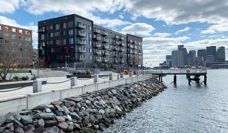
Photograph: A luxury residential development in East Boston sits in one of several flood paths the city has identified. Developers have raised elevations and re-created natural systems to help absorb inundation, but some wonder whether it will protect residents of the working-class neighborhood two blocks inland. Credit: Photo courtesy Anthony Flint.
Resilience District Concept Gathers Momentum in Seattle
By Emma Zehner, April 21, 2021
SHARE
Residents of the Duwamish Valley, a section of Seattle perched just south of downtown, face an array of environmental challenges, health disparities, and racial inequities. Saddled with a legacy of pollution from the heavy industry and highways nearby, they now face increasing flood risks due to climate change and concerns about displacement and affordability. The riverside neighborhoods of South Park and Georgetown have historically relied on community organizing to attempt to address these problems. But in recent years, the city of Seattle has taken a more active role in advancing environmental justice and equitable development in the Duwamish Valley by creating a cross-departmental Duwamish Valley Program, implementing the Duwamish Valley Action Plan, and collaborating with local activists and residents in new ways. Now, partners from the city and the community are exploring the feasibility of creating one of the nation’s first resilience districts.
Resilience districts have been implemented in New Orleans, Louisiana; Portland, Oregon; and other cities around the world. Although they sometimes go by other names, the basic concept is the same, as described by the city of Seattle: “a geographic strategy . . . focused on adapting to flood risk and other climate change impacts as a key first step towards adapting to a changing climate, while taking a comprehensive approach that fosters community resilience.”
Seattle’s approach specifically aims to coordinate investments in infrastructure related to affordable housing, parks, and climate change adaptation; prioritize the partcipation and decision-making of local residents and businesses, with a focus on building power and wealth for people of color and individuals with low incomes; and foster health and equity by identifying sustainable funding sources and equitable investment mechanisms, including value capture. The district will initially be managed by various city departments but will ultimately be led by the Duwamish Valley communities, who will establish partnerships with agencies, philanthropy, and private entities.
Credit: Blank Space LLC for the city of Seattle.
The vision for a resilience district, which had previously been discussed internally by city staff and community partners, turned into a concrete plan through partners’ participation in Connect Capital, a program run by the Center for Community Investment that helps place-based teams establish shared priorities and create pipelines of investable projects. Participants in the two-year process included representatives from Seattle Public Utilities (SPU); the city’s Office of Sustainability & Environment (OSE), Office of Planning & Community Development (OPCD), and Office of Economic Development (OED); the Seattle Foundation; the Duwamish River Cleanup Coalition (DRCC), a group of community, tribal, environmental, and small business groups impacted by pollution and remediation along the lower Duwamish River; and other stakeholders.
With planning now underway, city representatives are learning from models around the globe—from Brazil to New Zealand—that offer insights into how to equitably finance related projects, collaborate across sectors, and adapt to sea level rise. Funding from the Robert Wood Johnson Foundation (RWJF), granted at the end of 2020, will enable the project’s partners to take important next steps related to planning and piloting key elements of the resilience district.
“The community has been leading and working on these issues for decades, so it is really exciting to now see this work recognized and given support on the national level in ways that match the creativity and bold solutions being put forward by them,” Alberto J. Rodríguez, Duwamish Valley advisor at OSE and project colead, said. “This approach will allow us to collaborate in transformational ways.”
“This grant will make it possible for community groups, industrial businesses, public sector agencies, utilities, the port, and the county to continue to work together to address environmental hazards and build a more resilient community,” said Omar Carrillo Tinajero, associate director of innovation and learning at the Center for Community Investment. “Even in this difficult time, this work recognizes the importance of taking action to create a more equitable, smarter climate future.”
Project Background
Seventy percent of the residents of the Duwamish Valley’s two primary neighborhoods, South Park and Georgetown, identify as people of color. The environmental hazards they face include industrial pollution in the lower Duwamish River, which was declared a Superfund site in 2001; air pollution from State Highways 99 and 509 and Interstate 5, which all cut through the area; a lack of green space; and other challenges. During a community-run mapping exercise, residents identified noise pollution, vacant lots, a lack of healthy stores, and litter as additional “unhealthy” features. These factors have combined to create an average life expectancy eight years shorter in this zip code than in the city of Seattle and King County overall, and a full 13 years shorter than in more affluent, less diverse neighborhoods in Seattle. Further, by 2104, the routine flooding in this low-lying area is expected to become a daily occurrence.
Credit: Blank Space LLC for city of Seattle.
While the city has made efforts to address these problems, some of these actions have raised concerns among residents about displacement. SPU’s plans to invest $100 million in stormwater management infrastructure in the area and Seattle Parks & Recreation’s plans to improve and add parks, for example, have prompted increasing worries about displacement of current residents in a city with few affordable housing options. A 2015 analysis by Governing revealed that of seven U.S. Census tracts in Seattle that had experienced gentrification since 2000, five were in Georgetown and South Park, with median home values increasing an average of 47 percent between 2000 and 2013.
“We cannot be talking about a water treatment facility that is going to bring open space without thinking of displacement,” Paulina López, executive director of DRCC, said. Collaboration is critical, she said: “Our public utility doesn’t build affordable housing, but it should still be collaborating with the Office of Housing and other departments on its infrastructure investments.”
Since forming the Duwamish Valley Program in 2016, the city has commited to furthering social justice in policy and development, aiming to coordinate priorities across 18 city departments and strengthen relationships with community partners. Participating in Connect Capital helped the team shift from a focus on discrete projects and “symptoms” to a more proactive systems mindset, according to Rodríguez.
Throughout this partnership development and capacity building work, anti-displacement has repeatedly emerged as the top priority for residents. Departments such as OPCD and the Office of Housing are taking steps to address these concerns, including providing funding for capacity-building to the Duwamish Valley Affordable Housing Coalition (DVAHC), which was formed in 2017 to preserve existing affordability, develop a multipurpose community building, provide repairs, and acquire lots to build additional housing. The city is also buying land for affordable housing and providing $910,000 to Habitat for Humanity to build 13 two-bedroom, two-bath homes in South Park, which will be sold for $210,000 for a family with an annual income averaging $45,000 (in February 2021, the median list price of homes in this neighborhood was $525,000).
“We are working to shift to a culture of pairing community development with concrete anti-displacement actions,” said David W. Goldberg, strategic advisor with OPCD and project colead. “It looks like in the next few years the neighborhood will get both a park and new affordable housing.”
Mayor Jenny A. Durkan with the Duwamish Valley Youth Corps at an Earth Day celebration of Duwamish Alive! Credit: Alberto Rodríguez.
Planning: Local and International Models & Inspirations
The partners are thinking of the resilience district timeline in three stages, says Goldberg: “norming, forming, and performing.” At each of these stages, representatives from the community, philanthropy, and city will play evolving roles. During the “norming” stage, the city and community are organizing listening sessions and researching precedents. In the second stage, the city plans to develop regulatory options for enabling legislation and amendments to development standards. By the third phase, the community would hold the largest role and begin to cogovern the district, with the city playing a financing and legislative role.
With the funding from RWJF, the Duwamish Valley Program will focus on “norming” and “forming” by researching promising practices for three aspects of the district: cross-sector collaboration, sustainable funding sources and equitable investment mechanisms, and adaptation to sea level rise. The partners have already identified models in places as far-flung as San Juan, Puerto Rico, São Paulo, Brazil, and Christchurch, New Zealand, that are using strategies that could be adapted in the Duwamish Valley.
“We have built this concept from the needs of the community,” Rodríguez said. “As a result, we cannot find one model elsewhere that perfectly aligns with our work, but we have found bits and pieces that embody key aspects of the work that we want and plan to do.”
Cross-Sector Collaboration in San Juan
In communities along Caño Martin Peña, a tidal channel on the San Juan Bay National Estuary, residents face challenges familiar to the Duwamish Valley, including displacement pressures, flooding, and environmental hazards stemming from poor water infrastructure. In the early 2000s, the Puerto Rico Planning Board designated the area a special planning district and formed a public corporation to oversee the implementation of a development and land use plan. The corporation works with a nonprofit coalition to ensure widespread community involvement and participatory community planning as well as with the Caño Martin Peña Community Land Trust to prevent further displacement.
As envisioned, the resilience district will be a similar type of collaboration. To establish capacity for this type of collaboration, build relationships between the many partners in the Duwamish Valley, and address community skepticism about the approach, the city is convening listening sessions and plans to hire a facilitator and provide stipends to residents offering their expertise.
“Cross-sector collaboration is so important,” López said. “There are not a lot of opportunities for funders, governments, and community-based organizations to be sittng in the same Zoom room, thinking creatively about how to address the impacts of environmental injustices and climate change. This is a great opportunity to develop good strategies and be meaningful in the way that these strategies can be implemented.”
Sustainable Funding Sources & Equitable Investment Mechanisms in São Paulo
Funding mechanisms such as land value capture—which allows the public sector to recover and reinvest land value increases that result from public investment and government actions—could help fund affordable housing, green space, and other community priorities in the Duwamish Valley. The approach of São Paulo, recently highlighted in Land Lines, has resonated in Seattle. Since the early 2000s, São Paulo has used CEPACs, a form of land value capture in which developers pay the municipality a fee for additional development rights. Those fees are then used to fund public improvements, including social housing. The city also stipulates that all displaced families can resettle within the same geographic area, and that a fixed share of revenues must be invested in affordable housing.
Rodríguez and his colleagues are interested not only in land value capture, but in other tools for investing in public goods, such as health equity zones, hospital benefit zones, community benefits agreements, landscaping standards, and more.
“This work is not only about capturing value, but also ensuring its equitable distribution,” Rodríguez said. “We cannot run the risk of further exacerbating existing inequities and disparities.”
Adapting for Sea Level Rise in Christchurch
Finally, the cross-departmental team believes the Ōtākaro Avon River Corridor Regeneration Plan in Christchurch, New Zealand, may offer important lessons about how the Duwamish Valley can prepare for projected sea level rise. The project is run by Regenerate Christchurch, a quasi-public agency that formed in the wake of the 2011 earthquake, and takes a holistic approach to planning for present and future land use.
Regenerate Christchurch addresses both the infrastructure needs and the cultural ties of residents, indigenous populations, and representatives from private and nonprofit organizations to the river. In addition to drawing inspiration from Christchurch, the city’s team is also considering using scenario planning, a practice through which communities plan for an uncertain future by exploring multiple possibilities of what might happen, to address rising seas.
“Adaptation to sea level rise in the Duwamish Valley will be rooted in community resilience: power and wealth building today are as critical as engineered infrastructure to respond to climate change impacts tomorrow,” says Ann Grodnik-Nagle, climate policy advisor with SPU.
Learning by Doing: Duwamish Waterway Park Expansion Project
While thinking through the big ideas of the resilience district, the city is using this time to pilot community-led work on a smaller scale with the expansion of the Duwamish Waterway Park, South Park’s main riverfront green space. This “learning by doing” project will use an existing grant to purchase a one-acre site adjacent to an existing park and expand the facility to support community services and cultural programming. The group will start the project by leading a site plan to determine how community uses can be accommodated on the site and, ultimately, how the community could potentially own the land. According to Goldberg, this is one of several potential “proof-of-concept” projects being considered.
“This is a good way to prove the concept so we can learn and replicate something similar with bigger multimillion-dollar investments,” says Goldberg. “It is a way for us to exercise the muscles that we will need to have in place when the resilience district is operating.”
Emma Zehner is communications and publications editor at the Lincoln Institute of Land Policy.