La urbanización y las actividades humanas de las ciudades producen gases de efecto invernadero con impacto en la temperatura ambiente, las precipitaciones y la capa de hielo, lo que genera islas de calor, sequías, inundaciones y aumento del nivel del mar. Lo anterior tiene consecuencias para la infraestructura urbana y la disponibilidad de recursos básicos, al tiempo que provoca la pérdida de ecosistemas y desplazamientos de población, lo que afecta especialmente a los habitantes más vulnerables. A pesar de que las emisiones totales de gases de América Latina y el Caribe representan solo el 8,3% de las emisiones mundiales, la región es particularmente vulnerable al cambio climático debido a sus características geográficas, climáticas, socioeconómicas y demográficas (CEPAL, 2015). En este escenario, es urgente incrementar la resiliencia y reducir las emisiones de carbono de la región, especialmente a través de la implementación de políticas de suelo para la mitigación y adaptación climática.
Con el objetivo central de abordar las diferentes alternativas que existen para la acción climática desde las políticas de suelo, este curso busca brindar conceptos y herramientas para: 1) comprender la relación entre la urbanización y el cambio climático, y los riesgos que enfrentan las ciudades; 2) definir objetivos y explorar escenarios en la planificación urbana y climática; 3) identificar, evaluar e implementar instrumentos de gestión y financiamiento urbano para la acción climática; y 4) monitorear y evaluar las medidas implementadas.
El curso se realizará en una modalidad híbrida con grupos reunidos en seis localidades de la región (Colina, Chile; Quito, Ecuador; Ciudad de Guatemala, Guatemala; Ensenada, México; Asunción, Paraguay; Lima, Perú) para potenciar la reflexión compartida a partir de sus desafíos y experiencias particulares.
Adaptation, Environmental Planning, Land Value Taxation, Local Government, Resilience, Scenario Planning, Sustainable Development, Urban Design, Value Capture
Lo que prometen las megarregiones
Cómo la ampliación a escala podría ayudar a combatir los desafíos más urgentes de la actualidad
Por Matt Jenkins, October 31, 2022
SHARE
En el norte de California, tres agencias regionales que representan a unos 11 millones de personas se unen para abordar los problemas de planificación del transporte a largo plazo. En el noreste, una docena de estados colaboran en un esfuerzo por reducir las emisiones de gases de efecto invernadero. En otros lugares de los Estados Unidos, desde el suroeste hasta el medio oeste, los gobiernos y las organizaciones de las grandes áreas metropolitanas utilizan estrategias regionales para abordar los desafíos que atraviesan los límites jurisdiccionales.
Se trata de un enfoque que los planificadores fomentan desde hace tiempo, ya que las áreas metropolitanas estadounidenses en expansión parecían cada vez más destinadas a fusionarse. Jonathan Barnett recuerda haber asistido a una conferencia en Londres en 2004 y haber visto en una pantalla mapas del crecimiento urbano y el desarrollo regional previstos en los Estados Unidos. Por aquel entonces, Barnett era el director del Programa de Diseño Urbano de la Universidad de Pensilvania. Él y sus colegas habían estado reflexionando sobre las implicaciones de las proyecciones de la Oficina del Censo; según estas, la población de los Estados Unidos podría aumentar un 50 por ciento o más para el 2050, un incremento de más de 100 millones de personas.
“Lo que les llamó la atención a todos los presentes fue que en los mapas se observaba un patrón de a dónde se concentrarían esas personas”, dice Barnett. “[Estos patrones urbanos] se pueden ver desde el espacio y es como mirar las estrellas y ver Orión y Sagitario. Nos dimos cuenta de que estaba ocurriendo algo importante”.
Bob Yaro también estaba presente ese día. “Podías ver que, en todo el país, los suburbios de una región metropolitana se fusionaban con los suburbios de la siguiente”, recuerda Yaro, que por aquel entonces dirigía la Regional Plan Association mientras daba clases en la Universidad de Pensilvania. “Físicamente, estos lugares se integraban entre sí. Cuando observamos las tendencias económicas y demográficas, se podía ver que la vida de estas ciudades y áreas metropolitanas se estaba fusionando con la de sus vecinos”.
No era la primera vez que los geógrafos y los planificadores notaban que las áreas metropolitanas vinculadas pueden compartir economías, sistemas de recursos naturales, infraestructuras, historia y cultura. Pero a principios del s. XXI, el alcance y el ritmo del fenómeno alcanzaron nuevos niveles en los Estados Unidos.
Poco después de la conferencia de Londres, Armando Carbonell (que se jubiló del Instituto Lincoln este año tras dirigir su programa de planeamiento urbano por más de dos décadas) le dio al fenómeno un nombre que se mantendría: megarregiones.
Un grupo de planificadores, entre los que se encuentran Yaro y Barnett, retomó la causa de las megarregiones con el argumento de que estas zonas urbanas tienen una gran importancia a nivel nacional. “Más de 8 de cada 10 estadounidenses viven en estos lugares y representan el 90 por ciento de la economía del país”, dice Yaro. “Entonces está claro que, si estos lugares no prosperan ni operan a su capacidad máxima, la economía y la habitabilidad del país se verán afectadas”.
Esta primavera, el Instituto Lincoln publicó Megaregions and America’s Future, de Robert Yaro, presidente de la Alianza Ferroviaria del Atlántico Norte; Ming Zhang, director de Planificación Regional y Comunitaria en la Universidad de Texas en Austin; y Frederick Steiner, decano de la Facultad de Diseño Stuart Weitzman en la Universidad de Pensilvania. El libro sostiene que, si se administran de forma correcta y con creatividad, las megarregiones pueden mejorar la resiliencia ante el cambio climático, la gestión de recursos naturales, la competitividad económica y la equidad a nivel local, regional y nacional.
Qué constituye una megarregión
Durante más de un siglo, la región densamente poblada que se extiende desde Boston hasta Washington, DC, atrajo la atención de los geógrafos. En su libro de 1915 Cities in Evolution, Patrick Geddes designó al desarrollo urbano que se extiende desde Boston hasta Nueva York con el no muy atractivo término “conurbación”. En 1961, el geógrafo francés Jean Gottman se refirió a la región como “megaló-polis”. En 1967, Herman Kahn eligió un término que también carecía de encanto, “BosWash”.
Pasaron otras tres décadas hasta que este fenómeno que supera fronteras comenzó a recibir una atención académica más generalizada, pero en los últimos 20 años el ritmo se aceleró cuando la Universidad de Pensilvania, el Instituto Lincoln y otros comenzaron a trabajar para ayudar a que las personas comprendan qué son las megarregiones y cómo funcionan.
Las definiciones de qué constituye exactamente una megarregión varían; en general, se considera que es una economía regional que claramente se extiende más allá de un área metropolitana individual. “Pienso a las megarregiones como una forma de pensar en el espacio, más que como algo real”, dice Carbonell. “Las pienso como una construcción y una herramienta, [pero] las megarregiones no son fijas y cambian”.
La megarregión del norte de California se extiende por ciudades del Área de la Bahía de San Francisco, Sacramento y el Valle de San Joaquín. La región experimentó un aumento espectacular de los desplazamientos desde comunidades del interior, como Tracy y Stockton, hacia los puestos de trabajo en el Área de la Bahía, y tiene uno de los tiempos promedio de desplazamiento más largos del país.
James Corless dirige el Consejo de Gobiernos del Área de Sacramento, pero antes trabajó para la Comisión de Transporte Metropolitano, la agencia responsable de la planificación y el financiamiento del transporte regional en el Área de la Bahía. Dice que, a mediados de la década de 2000, las agencias regionales empezaron a considerar las ciudades ubicadas desde el Área de la Bahía hasta Sacramento como una megarregión emergente, y le dieron un nombre que la situaba directamente junto a lugares como So–Flo y Char–Lanta. “De hecho, acuñamos el nombre ‘San Framento’”, dice Corless. “Todo el mundo lo odiaba, pero captó la atención de la gente”.
En 2015, la Comisión de Transporte Metropolitano, el Consejo de Gobiernos del Área de Sacramento y el Consejo de Gobiernos de San Joaquín firmaron un memorándum de entendimiento a fin de crear un grupo de trabajo para la megarregión. Su objetivo era colaborar en cuestiones que trascendieran las fronteras de los 16 condados y las 136 ciudades a las que representaban colectivamente.
El esfuerzo tardó en cobrar impulso, precisamente por la extensión de la megarregión. “Veía que aparecían reuniones de la megarregión en mi calendario y que luego se cancelaban”, dice Corless. “Para que se reunieran los funcionarios electos de estos 16 condados, se necesitaba un día entero de viaje”.
La llegada de la COVID-19 implicó que se realizaran actividades gubernamentales a través de Zoom, lo que ayudó a salvar esas distancias y dio impulso al esfuerzo. “Al principio nos costó enfocarnos”, dice Corless. Sin embargo, de a poco, las entidades que participaban comenzaron a hacerse una pregunta simple: “¿Cuáles son nuestras fortalezas cuando estamos unidos?”.
A finales de 2021, el grupo de trabajo de la megarregión anunció una lista de una docena de proyectos centrados en el transporte, desde mejoras en las autopistas, hasta la ampliación de tres líneas ferroviarias regionales. El sistema ferroviario de alta velocidad de California, que está en construcción (pero lejos de estar terminado) no contribuye demasiado a los planes del grupo de trabajo, dice Corless. “No tengo ninguna duda de que el tren de alta velocidad será un cambio radical”, afirma. Pero, “si pudiéramos conseguir un ferrocarril fiable de velocidad media, lo aceptaríamos”.
De hecho, gran parte del esfuerzo megarregional se trata más de lo cotidiano que de los grandes proyectos de infraestructura. Los socios se centran en integrar los planes regionales y sincronizar los ciclos de planificación a largo plazo. “Dado que gran parte del transporte e incluso los mercados de viviendas están entrelazados”, dice Corless, “si pensamos en los próximos 25 años, tenemos que estar en sincronía”.
El concepto de megarregiones está asentándose, afirma Corless, de la misma manera que el surgimiento de las organizaciones de planificación metropolitana ayudó a afrontar los desafíos nuevos en la década de 1960. “Una vez que las ciudades estadounidenses se suburbanizaron, no se podía esperar que la ciudad central lo hiciera todo”, dice. “La gente se movía más, las economías habían crecido y los problemas trascendían los límites locales de la ciudad y el condado”.
Impulsar las megarregiones
¿Qué hace falta para que el concepto de megarregión (que básicamente busca incluir a esas organizaciones de planificación metropolitana en un grupo más grande) empiece a formar parte de la conciencia pública y el ámbito político?
Bob Yaro cree que una de las respuestas es la crisis climática, que podría empujar a las regiones a trabajar juntas de maneras nuevas. “Creo que hace falta una crisis para que haya un cambio grande en este país”, dice Yaro. “Hay historias sobre condados enteros que se quedan sin agua y eso solo va a empeorar. [Para abordar] el problema del clima, se necesitan estrategias de adaptación y mitigación, que probablemente sean más eficaces a nivel de la megarregión”.
Algunos ejemplos de cómo puede funcionar ese tipo de colaboración son la iniciativa de la RGGI en el noreste y la crisis actual del agua en el desierto del suroeste. Paradójicamente, allí las situaciones difíciles han propiciado una conexión más cercana. Las comunidades y los gobiernos observaron a sus vecinos y se dieron cuenta de que pueden hacer más cosas juntos.
Históricamente, los siete estados de los EE.UU. que dependen del agua del río Colorado, junto con México, han tenido una relación extremadamente conflictiva. Sin embargo, mientras los titulares recientes alertan sobre una catástrofe hídrica inminente, las partes llevan más de 20 años colaborando silenciosamente en acuerdos destinados a minimizar la vulneración colectiva que podrían sufrir. Un sentimiento de asociación, por más mínimo y propenso a tensiones continuas que sea, ha reemplazado la antigua perspectiva más cerrada hacia el río.
A medida que las regiones metropolitanas se unen y los desafíos globales aumentan, un creciente sentimiento de destino compartido con vecinos históricamente distantes podría ayudar a abordar todo tipo de problemas que antes parecían insuperables.
“Creo que una de las cosas que tenemos que hacer es redefinir el concepto de ‘hogar’, y el suroeste es el ejemplo más claro de por qué hay que hacerlo”, afirma Yaro. “Se trata de redefinir el hogar a esta escala mayor. Los límites finales dependerán del sentido de asociación de cada comunidad con sus vecinos, pero el lugar no prospera a menos que nosotros lo hagamos”.
Matt Jenkins es un escritor independiente que colaboró con New York Times, Smithsonian, Men’s Journal y muchas otras publicaciones.
Imagen principal: EE.UU. visto desde el espacio de noche. Crédito: DKosig via iStock.
Referencias
Barnett, Jonathan. 2020. Designing the Megaregion: Meeting Urban Challenges at a New Scale. Washington, DC: Island Press.
Florida, Richard, Tim Gulden y Charlotta Mellander. 2008. “The Rise of the Mega-Region”. Cambridge Journal of Regions, Economy and Society 1(3): 459–476.
Nelson, Garrett Dash y Alasdair Rae. 2016. “An Economic Geography of the United States: From Commutes to Megaregions”. PLOS ONE. 30 de noviembre.
Yaro, Robert D., Ming Zhang y Frederick R. Steiner. 2022. Megaregions and America’s Future. Cambridge, MA: Instituto Lincoln de Políticas de Suelo.
Land Matters Podcast: Confronting Extreme Heat in Africa: A Conversation with the Mayor of Freetown, Sierra Leone
Assessing all the climate threats that rain down on West Africa, the mayor of Freetown, Sierra Leone, Yvonne Aki-Sawyerr, was convinced that extreme heat needed to be a top priority.
“There are more deaths from extreme heat than there are from the more visible and tangible disasters,” she said on the latest episode of the Land Matters podcast. “In our case, the vulnerable are mainly those living in informal settlements. That’s 35 percent of our city’s population, and in those informal settlements, the housing structures are typically made from corrugated iron. With increased temperatures, you’re effectively living in an oven.”
The concern led Aki-Sawyerr to appoint Africa’s first chief heat officer, with the support of the Arsht-Rockefeller Foundation Resilience Center. One of the first practical interventions was to provide shade covers at the city’s open-air markets, where primarily women sit in the sun for long hours.
In a wide-ranging interview, also available at Land Lines magazine as the latest installment of the Mayor’s Desk feature, Aki-Sawyerr said the aim is to build resilience for impacts being felt now, but also plan for long-range sustainability. She detailed the promise to plant a million trees and the planning initiative she launched after being elected in 2018, Transform Freetown.
Aki-Sawyerr, who previously served as head of the Freetown City Council, built her career as a finance professional. She was part of the campaign against blood diamonds and was instrumental in the response to the Ebola crisis in 2014. She has delivered two TED talks, including one about turning dissatisfaction into action. Named to the Time100 Next list of emerging leaders, she has been active in the C40 Cities global network.
As part of an effort to maintain not only environmental but fiscal sustainability, she also explained how the city overhauled its property tax assessment and collection practices.
The Lincoln Institute has been active in Africa, working with governments, scholars, and practitioners on issues like climate change, the property tax, and the fiscal health of local governments, and on using value capture to fund affordable housing and many other priorities.
When you think about innovations in development and construction, wood probably doesn’t leap to mind. It is, to put it mildly, an old-school material. But “mass-timber” construction—which involves wood panels, beams, and columns fabricated with modern manufacturing techniques and advanced digital design tools—is sprouting notable growth lately. Advocates point to its potential climate impact, among other attributes: using sustainably harvested mass timber can halve the carbon footprint of a comparable structure made of steel and concrete.
According to wood trade group WoodWorks, more than 1,500 multifamily, commercial, or institutional mass-timber projects had either been built or were in design across all 50 states as of September 2022—an increase of well over 50 percent since 2020. The Wall Street Journal, citing U.S. Forest Service data, reports that since 2014 at least 18 mass-timber manufacturing plants have opened in Canada and the United States.
The building blocks of mass-timber construction are wood slabs, columns, and beams. These are much more substantial than, say, the familiar two-by-four, thanks to special processes used to chunk together smaller pieces of wood into precisely fabricated blocks. The end result includes glue-laminated (or “glulam”) columns and beams, and cross-laminated (or CLT) slab-like panels that can run a dozen feet wide and 60 feet long. The larger panels are mostly used for floors and ceilings, but also for walls. The upshot, as the online publication Vox put it, is “wood, but like Legos.” Major mass-timber projects tend to showcase the material, resulting in buildings whose structural elements offer a warmer, more organic aesthetic than do steel and concrete.
Both the process and interest in wood’s potential have been building momentum for a while. Pioneered in Austria and used elsewhere in Europe since the 1990s, the practice has gradually found its way to other parts of the world. In an often-cited 2013 TED Talk, Vancouver architect Michael Green made a case for this new-old material: “I feel there’s a role for wood to play in cities,” he argued, emphasizing mass timber’s carbon sequestration properties—a cubic meter of wood can store a ton of carbon dioxide; building a 20-story structure of concrete would emit more than 1,200 tons of carbon, while building it with wood would sequester over 3,000 tons. Plus, mass-timber structures can withstand earthquakes and fire.
When Green gave his TED talk in 2013, the tallest mass-timber structures were nine or 10 stories high. But Green argued this new fabrication process could be successfully used in structures two or three times that height. “This is the first new way to build a skyscraper in probably 100 years, or more,” he declared, adding that the engineering wouldn’t be as hard as changing the perception of wood’s potential. Lately that perception has been getting a fresh boost thanks to a spate of eye-catching projects—including a 25-story residential and retail complex in Milwaukee and a 20-story hotel in northeastern Sweden—and proposals for even taller mass-timber buildings.
Because mass timber is prefabricated in a factory and shipped to the site, unlike concrete structures made in place, the design details must be worked out precisely in advance, requiring intense digital planning and modeling. This can ultimately make construction processes more efficient, with fewer workers and less waste. Most mass-timber projects still incorporate other materials, notes Judith Sheine,an architecture professor at the University of Oregon (UO) and director of design for the TallWood Design Institute, a collaboration between UO’s College of Design and Oregon State University’s Colleges of Forestry and Engineering that focuses on advancing mass-timber innovation. “But mass timber can replace steel and concrete in many, many applications, and it’s becoming increasingly popular,” she says. “That’s due to new availability, but also to an interest in using materials that have low embodied carbon.”
TallWood has run dozens of applied research projects and initiatives, addressing everything from code issues to supply chain challenges to building performance in an effort to help get more advanced and engineered timber into use. The institute is part of the Oregon Mass Timber Coalition, a partnership between research institutions and Oregon state agencies that was recently awarded $41.4 million from the U.S Economic Development Build Back Better Regional Challenge. That funding is meant to back “smart forestry” and other research initiatives tied to increasing the market for mass timber.
Of course, part of the newfangled material’s environmental promise depends on the back-end details, notably how and where the timber is harvested. Advocates of the sector argue that its expansion won’t cause undue pressure on forests, in part because mass-timber products can be made from “low-value” wood—smaller-diameter trees that are already being culled as part of wildfire mitigation, diseased trees, and potentially even scrap lumber.
Conservation groups and other forestry experts are proceeding a bit more cautiously. The Nature Conservancy undertook a multiyear global mass-timber impact assessment in 2018, researching the potential benefits and risks of increased demand for mass-timber products on forests, and is developing a set of global guiding principles for a “climate-smart forest economy”—best practices that will help protect biodiversity and ecosystems as the mass-timber market grows.
Often, builders and developers who specifically want to tout the use of mass-timber materials insist on sourcing that’s certified as sustainable, according to Stephen Shaler, professor of sustainable materials and technology in the University of Maine’s School of Forest Resources. “That demand is in the marketplace right now,” he says.
Beyond an interest in sustainability, there’s another reason for the proliferation of mass-timber projects: biophilia, or the human instinct to connect with nature. “Being in a wood building can just feel good,” Shaler says. That’s not just a subjective judgment; small studies have shown that wood interiors improve air quality, reduce blood pressure and heart rates, and can improve concentration and productivity.
The developers of the 25-story Milwaukee building, the Ascent, reportedly pursued the mass-timber approach largely for aesthetic reasons, and for the promotional value of its distinct look. Presumably the marketing payoff didn’t hurt: as the tallest wood skyscraper in the world, the Ascent has been a centerpiece of mass-timber press attention. But there’s another value to the public exposure: the 284-foot-high Ascent and other high-rise projects may not portend the future of all skyscrapers, but they demonstrate the possibility of safely building with mass timber at large scale. And that may help sway regulators and planners—particularly when it comes to approving the smaller-scale buildings that could be more important to proving mass timber’s real potential. “The majority of the use is likely going be in the mid-rise, six- to eight-story kind of project,” Shaler says.
The International Building Code permits wooden buildings up to 18 stories; the Ascent developers obtained a variance partly because their final design incorporated two concrete cores. As Sheine and Shaler both underscore, most mass-timber projects still incorporate at least some concrete, steel, or other materials. That’s just fine, Shaler says: mass timber should be viewed as a comparatively new option that can help improve carbon footprints, not as a full-on replacement for traditional materials. And new options are always useful—even when they’re as old-school as wood.
Rob Walker is a journalist covering design, technology, and other subjects. He is the author of The Art of Noticing. His newsletter is at robwalker.substack.com.
Image: Mass timber construction. Credit: Courtesy of ACSA.
Peking University–Lincoln Institute Center Celebrates 15th Anniversary
By Katharine Wroth, November 28, 2022
SHARE
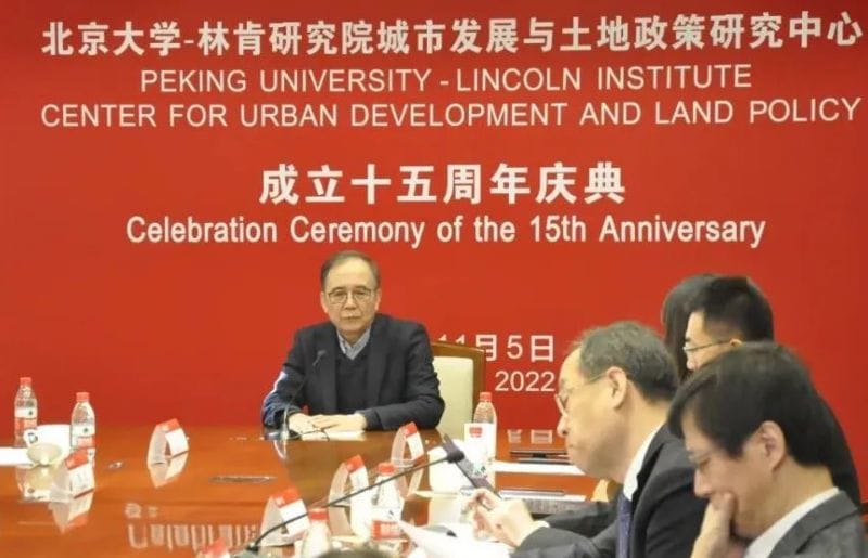
This fall marked the 15th anniversary of the Peking University–Lincoln Institute Center for Urban Development and Land Policy (PLC). Established in 2007, the center has become a leading authority on land policy issues in China, including the property tax, municipal finance, land and housing policies, and land conservation. To celebrate this milestone, the PLC held an event on November 4 that included commemorative remarks, a formal recommitment to the partnership between the two institutions, and several academic presentations on urban development and climate change.
“The Lincoln Institute works globally on topics largely relating to land policy, and the joint center is an exceptional platform for our China program,” said Katie Lincoln, chief investment officer and board chair of the Lincoln Institute, who delivered congratulatory remarks by video. “During the past 15 years, the center has held numerous conferences, undertaken research and demonstration projects, shared in scholarly exchanges, and happily gained recognition both in and out of China.”
In addition to Lincoln, several current and former leaders from the two institutions joined the celebration virtually or in person, including Jin Zhang, vice president of Peking University; Jianhua Lin, former president of Peking University; Yansong Li, former vice president of Peking University; George W. McCarthy, president of the Lincoln Institute; Gregory Ingram, former president of the Lincoln Institute; and Joyce Man, former director of the PLC.
“We are now at a difficult time of Sino-U.S. relations,” said former PKU President Lin. “But I believe that the mutual trust between our two institutions and the confidence about the value of what we do will continue to be a foundation for us to cooperate and move forward.”
Former Peking University President Jianhua Lin delivers remarks at the PLC’s 15th anniversary celebration. Credit: Courtesy of PKU.
During the event, Zhang and McCarthy signed an agreement for continued collaboration between the two organizations. “In the next few years, the PLC will add a new focus on land use and climate change, in support of China’s ambitious goal of achieving net-zero carbon goals by 2060,” noted McCarthy. “The PLC also will help the Lincoln Institute in its global efforts to address the climate crisis. The unique cooperation between the Lincoln Institute and PKU over the last 15 years has been fruitful for China, the United States, and the world in [finding land-based solutions to] economic, social, and environmental challenges. We are excited to embark on another five-year journey together.”
The center, which conducts research, training, policy analysis, academic exchanges, advisory services, and demonstration projects throughout China, also invited several scholars, fellowship recipients, and others who have been involved with its work over the years to share reflections.
“I worked with PLC for more than ten years, from winning the Peking University–Lincoln Center scholarship, to guiding students to participate in the center’s fund application, to becoming a partner of the center’s work and research,” said De Tong, associate professor at Peking University Shenzhen Graduate School. “Scholars at the center have become my inspiring mentors and friends, and colleagues at the center have also become comrades-in-arms at work and friends in life.”
PLC invited former scholarship recipients and other collaborators, including De Tong of Peking University Shenzhen Graduate School, to share reflections at the event. Credit: Courtesy of PKU.
The center has launched an essay contest open to those who have been involved with the PLC over the years, from scholarship recipients to business collaborators to conference participants. Five winning essays, selected in January, will receive a small monetary prize; a copy of the Lincoln Institute book Infrastructure Economics and Policy: International Perspectives, coedited by José A. Gómez-Ibáñez and Zhi Liu, who leads the PLC as director of the Lincoln Institute’s China program; a copy of Advanced Economic Geography by Canfei He, dean of the College of Urban and Environmental Sciences at PKU and associate director of the PLC; and publication on the PLC website.
The second half of the day’s events was structured as an online forum on climate change and urbanization in the context of China’s dual-carbon goal, which seeks to reach peak carbon by 2030 and achieve carbon neutrality by 2060. Leading policy makers and scholars from China, Hong Kong, and the United States shared their latest thoughts and studies on topics including green building, urban equity, and urban-rural integration, drawing an audience of more than 600 researchers, planners, and others.
“The dual-carbon goal is a major challenge for China, but also presents new opportunities for China’s continuing urbanization,” said PLC Director Liu. “Urbanization and carbon net-zero has been a hot topic in China’s policy debates, which have been getting more substantive and concrete over the last two years. I found myself learning a lot from these presentations, which deepened my understanding about the challenges and opportunities that the goal of carbon net-zero will bring to our urbanization for the next few decades.”
Forum topics and presenters included:
the evolution and future of green building, by Dr. Baoxing Qiu, former Deputy Minister of the Ministry of Housing and Urban-Rural Development;
carbon reduction models for commercial real estate, by Professor Siqi Zheng of the Department of Urban Studies and Planning of MIT;
equity and governance under China’s dual-carbon goal, by Professor Shenjing He from the Department of Urban Planning and Design of the University of Hong Kong;
carbon reduction through urban agglomeration, by Professor Ming Lu from Antai School of Economics and Management, Shanghai Jiao Tong University; and
urban-rural integration and rural revitalization, by Professor Shouying Liu from the School of Economics of Renmin University.
Visit the “Our Work” section of our website to learn more about the PLC and to find information about how to connect with the center on WeChat.
Lead image: Lincoln Institute President and CEO George W. McCarthy and Peking University Vice President Jin Zhang celebrate the renewal of the collaborative agreement that established the Peking University-Lincoln Institute Center for Urban Development and Land Policy. Credit: Courtesy of PKU.
Esta entrevista, que se ha editado por motivos de espacio, también está disponible como pódcast de Land Matters.
O
riginario de Vermont y elegido por primera vez en 2012, Miro Weinberger ejerce su cuarto período como alcalde de Burlington, Vermont. Asistió a Yale y a la Escuela de Gobierno Kennedy de Harvard, y trabajó en Habitat for Humanity antes de fundar su propia empresa de desarrollo de viviendas asequibles. También es atleta a medio tiempo; juega como receptor en una liga amateur de béisbol para mayores de 35 años.
Hace tiempo que Vermont es un sitio progresista con una población dedicada a las medidas medioambientales, ya sea energía solar o eólica, vehículos eléctricos o prácticas agrícolas sostenibles. En 2014, Burlington, la capital y agente del cambio, en donde surgió Bernie Sanders (que fue alcalde entre 1981 y 1989), se convirtió en la primera ciudad en obtener el 100 por ciento de su energía a partir de fuentes renovables, un objetivo que se había planteado en 2004. Ahora, Weinberger y otros dirigentes siguen trabajando sobre esas bases y se comprometen a hacer que la energía, el transporte y el sector constructor dejen de usar combustible fósil.
ANTHONY FLINT: Cuéntenos sobre este objetivo ambicioso de ser una ciudad con energía de cero emisiones netas para 2030. ¿Cómo será y cuáles son los pasos para cumplir la meta?
MIRO WEINBERGER: Como resultado de décadas de compromiso con la creación de construcciones eficientes y la climatización, Burlington, como comunidad, usa menos electricidad en 2022 que la que consumía en 1989, a pesar de la proliferación de dispositivos electrónicos nuevos y demás. . . suena excepcional y lo es. Si le resto del país hubiese seguido nuestros pasos, hoy en día tendríamos alrededor de 200 plantas energéticas a base de carbón menos.
Cuando nos convertimos en una ciudad con electricidad 100 por ciento renovable en 2014, había mucho interés en cómo Burlington lo había logrado. Después de hablar con equipos de filmación de Corea del Sur y Francia, y de responder muchísimas preguntas sobre cómo lo habíamos logrado, llegué a la conclusión de que fue por dos grandes motivos. En primer lugar, la voluntad política. En segundo lugar, teníamos un departamento de electricidad municipal que tenía mucha experiencia técnica y que podía hacer que la transformación a fuentes renovables fuese asequible.
En pocas palabras, definimos las cero emisiones netas como el no uso de combustibles fósiles, o el uso de combustibles fósiles con cero emisiones netas, en tres sectores. En el sector eléctrico ya lo logramos. Eso equivale al 25 por ciento del objetivo total. Los otros sectores son el transporte y el térmico, es decir, cómo calefaccionamos y refrigeramos nuestros edificios.
La estrategia más importante es la electrificación. Electrificar todos los autos y los camiones con base aquí en Burlington. Cambiar los sistemas de calefacción y refrigeración a distintas tecnologías eléctricas; es probable que la más común sea la de las bombas de calor de clima frío.
Por último, para redondear la estrategia, buscamos implementar un sistema energético por distrito que capture el calor residual [de la planta de biomasa de la ciudad] y lo use para calefaccionar algunos de los edificios institucionales principales. También estamos haciendo modificaciones en la red de transporte para que el transporte activo represente un mayor porcentaje de los viajes en vehículos y así reducir el uso de combustible fósil. Esas son las estrategias principales planificadas.
AF:¿Hay algún componente que le haya parecido más complejo en cuanto a aplicarlo en toda la ciudad?
MW: En general, estoy bastante conforme con el progreso que hicimos. De hecho, en la primera actualización de 2021, descubrimos que estábamos encaminados para cumplir esta meta increíblemente ambiciosa de dejar de usar combustibles fósiles para 2030.
Aunque debo admitir que parte de eso se debe, como todos sabemos, a que 2020 fue un año excepcional en el que las emisiones provenientes del transporte se redujeron drásticamente por la pandemia. Recibimos una medición nueva hace poco y vimos un aumento, por lo que no estamos tan encaminados luego de dos años como lo estábamos [luego] de uno. Ese aumento que se produjo aquí en Burlington fue de alrededor de un cuarto del aumento de las emisiones a nivel nacional. Es decir, tuvimos un aumento del 1,5 por ciento después de la pandemia, mientras que las emisiones aumentaron un seis por ciento en el resto del país. Hemos notado un aumento muy rápido en la adopción de las bombas de calor y los vehículos eléctricos en los últimos dos años desde que propusimos incentivos a los que llamamos estímulos verdes al principio de la pandemia.
Sin embargo, a veces siento que estamos peleando con una mano atada atrás de la espalda, porque la electrificación y las tecnologías renovables luchan en desventaja. Hoy en día, el costo de quemar combustibles fósiles no se refleja correctamente en la economía. Tenemos que encontrar la forma de ponerle un precio al carbono. El hecho de que no lo tenga es lo que evita que progresemos. Cuando lo logremos, y sé que lo haremos porque es inevitable que demos con la política correcta, al igual que otras jurisdicciones en todo el mundo, creo que tendremos viento a favor para poner en marcha todas estas iniciativas. Será de gran ayuda para todo lo que estamos intentando hacer.
AF:Quiero asegurarme de estar entendiendo bien. ¿Quiere que todos en Burlington tengan vehículos eléctricos para 2030? ¿Estamos hablando de una ampliación a escala y adopción de este tipo?
MW: Básicamente, sí. Eso es lo que necesitaríamos para cumplir el objetivo. Eso o inversiones de compensación que nos ayuden a lograrlo, pero nos tomamos con mucha seriedad el hecho de hacer todo lo posible para lograr esta transformación lo más rápido posible.
Hace un año entró en vigencia una ordenanza de zonificación en la que se establece que las edificaciones nuevas en Burlington no pueden usar combustibles fósiles como fuente primaria de calefacción. No prohibimos el combustible fósil porque nos pareció muy oneroso y porque la tecnología no está lista para eso. Reglamentar la fuente primaria de calefacción puede reducir el impacto de las construcciones nuevas en un 85 por ciento. En las últimas semanas, el estado aprobó un cambio en nuestro estatuto que nos permite ir más allá y establecer reglamentaciones nuevas para todas las construcciones en Burlington.
Para la próxima asamblea municipal en marzo, queremos tener lista una ordenanza nueva para someter a votación, que fijará requi-sitos para la transformación de los sistemas mecánicos de las construcciones más grandes, tanto nuevas como existentes, cuando lleguen al final de su vida útil. Por ejemplo, cuando las calderas se rompan, tendremos una estrategia mediante nuestra empresa de servicios públicos que ofrecerá incentivos generosos, y también implementaremos normas reglamentarias que requerirán una transformación.
AF:Quiero saber más sobre los servicios públicos. Mencionó Burlington Electric y, por supuesto, también está Green Mountain Power. ¿Qué tan importantes son, dado que las empresas de servicios públicos de otros lugares parecen desconfiar de las energías renovables y podrían llegar a dificultar la transición?
MW: Debo decir que una década en un cargo público lidiando con estos problemas me ha hecho un defensor acérrimo del control público de la energía. El departamento de electricidad fue una gran parte de todo el trabajo que describí de los últimos 30 años. Creo que es más difícil para los municipios, los pueblos y los alcaldes que no tienen su propio servicio de electricidad. Hay cosas que cualquier comunidad local puede hacer para colaborar y, cuando es necesario, ejercer presión pública sobre las empresas de servicios públicos, que usualmente deben responder ante una autoridad reglamentaria pública. Creo que hay formas de hacer que otras empresas de servicios públicos hagan lo mismo que está haciendo Burlington Electric. En Vermont, es emocionante escuchar que la otra empresa de servicios públicos que fue muy innovadora, Green Mountain Power, es una empresa de servicios controlada por inversores.
Si nos acercamos al objetivo de cero emisiones netas, significará que estaremos vendiendo mucha más electricidad que ahora. Creemos que será al menos un 60 por ciento más que hoy en día. Ahora, cuando alguien compra un vehículo eléctrico y lo carga en Burlington, si lo hacen de noche, podemos venderles energía fuera del horario de mayor demanda de manera que la empresa de servicios públicos obtiene más ganancias. Económicamente es muy bueno. Por eso podemos ofrecer estos incentivos muy generosos: cada vez que ponemos otro vehículo eléctrico o una bomba de calor en funcionamiento, es una nueva fuente de renta para la ciudad. En su mayoría, estos incentivos se autofinancian con esa renta nueva. Me parece que seguir este camino es una buena jugada económica.
AF:Vermont se convirtió en un destino muy popular para los refugiados climáticos más adinerados que compran suelo y construyen viviendas. ¿Cuáles son las ventajas y las desventajas de esto?
MW: Tiene razón, hay muchos refugiados climáticos aquí. También los hay de la pandemia. El mercado de viviendas está bajo mucha presión, y ese es el aspecto negativo. Hace mucho que hay una crisis aguda de viviendas, pero ahora la situación está peor que nunca. El lado positivo es que quizás fuerce a Vermont a considerar seriamente establecer reglas para el uso del suelo a nivel local y estatal que posibiliten la construcción de más viviendas.
Se necesitan más viviendas de manera urgente. Es un aspecto que debemos mejorar y creo que habrá beneficios medioambientales si lo hacemos. Para mí, más gente viviendo en una ciudad ecológica como Burlington es una buena compensación para el medio ambiente.
AF: ¿Tiene otras estrategias en mente para hacer que Burlington, como ciudad ecológica, sea o siga siendo asequible? Burlington tiene un fideicomiso de suelo comunitario exitoso, ustedes fomentan las viviendas accesorias, hay zonificación inclusiva. . . ¿Qué sigue?
MW: Tenemos mucho trabajo por hacer en cuanto a las ordenanzas de zonificación y la reforma de uso del suelo a nivel estatal. En este momento, en Vermont, muchos proyectos buenos, ecológicos, de eficiencia energética en áreas habitadas, deben pasar por procesos de permisos de uso del suelo a nivel local y estatal. Estos procesos son casi redundantes y enlentecen todo, aumentan el costo y crean muchas oportunidades para que surjan obstrucciones. Hay mucho trabajo por hacer y estamos enfocados en ello. Actualmente, estamos trabajando en tres esfuerzos principales de mejora de la zonificación y se está debatiendo mucho la reforma de la Ley 250 [ley de uso y desarrollo del suelo de Vermont] a nivel estatal.
AF:Por último, ¿qué consejo les daría a los dirigentes de otras ciudades para que tomen acciones climáticas similares, en especial en lugares que no están tan preparados como Burlington?
MW: Cuando hablo con otros alcaldes al respecto, intento dejar en claro que esta es un área en la que el liderazgo político [y la voluntad de la comunidad] puede tener un gran impacto. Cuando asumí, casi no había energía solar en Burlington. Esa fue nuestra prioridad y cambiamos algunas reglas sobre los permisos. Hicimos que fuese más fácil para los consumidores instalar paneles solares en sus viviendas.
La empresa de servicios públicos aportó lo suyo y, en pocos años, nos convertimos en una de las ciudades del país con más energía solar per cápita. Ahora estamos en el puesto n.º 5 a nivel nacional. En un momento, éramos la única ciudad de la costa este entre las primeras 20, y eso no es casualidad. Es porque tomamos la decisión de enfocarnos en ese tema y hacer un cambio. Se puede lograr un gran impacto.
En un momento en el que la emergencia climática es una amenaza existencial, en un momento en el que claramente el gobierno federal está paralizado y no puede impulsar cambios, y en el que muchos gobiernos estatales están en la misma situación, los alcaldes y las ciudades pueden demostrar progresos en el terreno. Creo que, cuando lo hacemos, le demostramos a la gente lo que es posible.
Anthony Flint es miembro sénior del Instituto Lincoln, conduce el ciclo de pódcasts Land Matters y es editor colaborador de Land Lines.
Fotografía: Burlington, Vermont. Crédito: Denis Tangney Jr. via iStock/Getty Images.
Retorno de la inversión
Según investigaciones, la acción del cambio climático está relacionada con aumentos del valor del suelo y la propiedad
n la ciudad china de Zhengzhou, un centro de fabricación ubicado casi a mitad de camino entre Pekín y Shanghái, un smog continuo que irrita los ojos colocaba a la ciudad en las listas de las ciudades más contaminadas del mundo. Hace casi10 años, los dirigentes locales se unieron en un plan de acción nacional e integral para limpiar el aire, iniciado por varios departamentos gubernamentales centrales y diseñado para reducir las emisiones de la industria, la producción energética, el uso del suelo y otras actividades de consumo.
Unos años más tarde, los resultados eran claros: nada extremo, pero cielos más celestes y una diferencia lo suficientemente notoria para influir en el comportamiento social, como la disposición de la gente a viajar y estar al aire libre. Un equipo de investigadores descubrió algo más: la mejora en la calidad del aire se relacionaba con un aumento general del valor de las propiedades.
Mediante un modelo espaciotemporal que cuantificaba la asociación entre el aire más puro y el valor del suelo, los investigadores determinaron que mejorar la calidad del aire en un 10 por ciento aumentaba un 5,6 por ciento el valor de las propiedades en toda la ciudad, dice Erwin van der Krabben, profesor en la Universidad Radboud en Países Bajos. Con el tiempo, eso podría dar como resultado un estímulo de US$ 63.000 millones, dice van der Krabben.
“Si se mejora aún más la calidad del aire, podemos predecir cuánto valor obtendremos”, dice van der Krabben, que está documentando las ramificaciones de la acción climática a nivel mundial. Hace poco coescribió un documento de trabajo del Instituto Lincoln sobre la calidad del aire y el valor del suelo en China, junto con Alexander Lord de la Facultad de Ciencia Medioambiental de la Universidad de Liverpool y Guanpeng Dong, profesor de Geografía Humana Cuantitativa en la universidad de Henan (Lord, van der Krabben y Dong, 2022).
La idea de que la acción medioambiental aumenta el valor del suelo y las propiedades puede parecerle obvia a muchos, pero, en general, creo que no se ha demostrado completamente. El tipo de análisis realizado en Zhengzhou es importante porque vincula directamente las mejoras medioambientales con un aumento del valor. Demostrar la relación es fundamental para respaldar la herramienta financiera que podría ser clave para abordar la crisis climática: la recuperación de plusvalías.
La recuperación de plusvalías, una herramienta financiera poco conocida en el pasado, se usa en todo el mundo para ayudar a financiar el transporte, la vivienda asequible, los espacios al aire libre y otras obras de infraestructura pública. El enfoque requiere que los emprendedores inmobiliarios y los propietarios aporten una parte de los aumentos del valor de las propiedades o del suelo, fomentados por la inversión pública y las acciones gubernamentales. Las municipalidades destinan la renta generada a obras de infraestructura u otros proyectos que benefician al público (Germán y Bernstein, 2020).
Mientras el mundo se prepara para invertir billones de dólares en un esfuerzo masivo para dejar atrás los combustibles fósiles, reducir las emisiones y generar resiliencia, la recuperación de plusvalías podría ayudar a subsanar la brecha financiera climática internacional, en especial a nivel local.
Determinar que lo que es bueno para el planeta es bueno para la economía, dice van der Krabben, explica con claridad la premisa fiscal de usar la recuperación de plusvalías. En China, donde el suelo es propiedad del estado y se arrienda a los emprendedores inmobiliarios, los aumentos del valor del suelo se añaden al precio que pagan los emprendedores. “Si las ciudades chinas actúan de manera racional, si invierten ese ingreso adicional de la renta del suelo, si continúan destinando esas inversiones a generar aire más puro, se logra un círculo virtuoso”, dice.
En consecuencia, se implementan metodo-logías de valuación y tasación cada vez más sofisticadas para describir el impacto de la acción gubernamental en el valor del suelo y la propiedad, y no solo para detallar cómo una estación de transporte o un parque resiliente a las inundaciones crea una mejora en el barrio local, sino cómo las políticas más amplias, como los requisitos de aire puro o las políticas que fomentan la actividad física, pueden tener un impacto positivo en un público más amplio.
El análisis del “círculo virtuoso” no es solo una razón económica poderosa que respalda la responsabilidad compartida del financiamiento de la acción climática, sino que también es una razón moral. Por lo general, en muchos lugares, los emprendedores inmobiliarios y los propietarios obtienen beneficios inesperados, generados por las inversiones públicas.
“Hay una falta de financiamiento bien documentada de las acciones que se necesitan para abordar la crisis climática”, dice Amy Cotter, directora de Estrategias Climáticas en el Instituto Lincoln. “Una parte muy pequeña funciona como la recuperación de plusvalías: se crea a partir de la misma acción que posibilita, bajo control local”. La recuperación de plusvalías “no solventará el financiamiento climático, pero tiene el potencial de subsanar una brecha importante”, dice Cotter.
La estación de ferrocarril Canary Wharf en el este de Londres. Las políticas de recuperación de plusvalías lograron un retorno de más de US$ 1.200 millones de los costos de capital de US$ 23.000 millones para la red de ferrocarriles, también conocida como la línea Elizabeth. Crédito: Jui-Chi Chan vía iStock/Getty Images Plus.
UNA CARACTERÍSTICA LLAMATIVA del estudio de caso de la contaminación aérea de Zhengzhou es que los beneficios se distribuyeron por toda la ciudad. Pero en los contextos urbanos, una amplia gama de proyectos y políticas que pueden contribuir a la resiliencia ante el cambio climático se están poniendo de manifiesto en términos económicos, tanto a nivel de una cuadra de la ciudad como de todo un barrio:
La Ordenanza Eco Eficiencia del distrito Metropolitano de Quito, que ganó un premio Guangzhou en 2021 por innovación urbana, fomenta la eficiencia energética y la densidad vendiéndoles a los emprendedores inmobiliarios el derecho a construir edificios más altos si tienen elementos ecológicos o están cerca de un medio de transporte público. Desde que la ordenanza entró en vigencia en 2016, se aprobaron 35 proyectos que tuvieron tanto éxito que los emprendedores inmobiliarios no tuvieron problemas en devolver una parte de las ganancias mediante esta herramienta de recuperación de plusvalías. La ciudad invertirá los US$ 10,7 millones recaudados hasta el momento en mejoras, como parques y viviendas asequibles, y está adoptando la ordenanza como parte de su nuevo plan de administración y uso del suelo.
En un estudio realizado por Center for Neighborhood Technology (CNT) y SB Friedman Development Advisors, se descubrió que las instalaciones de infraestructura verde de agua pluvial en Seattle y Filadelfia, como los jardines infiltrantes y los bajíos, daban como resultado un aumento estadísticamente importante en los precios de venta de las viviendas cercanas (CNT y SB Friedman Development Advisors, 2020). Duplicar los metros cuadrados de jardines infiltrantes, bajíos, áreas con plantas o pavimento permeable a 75 metros de una vivienda se asocia con un valor de venta entre 0,28 y 0,78 por ciento mayor, en promedio.
En Buenos Aires, una valuación similar de proyectos de infraestructura azul-verde propuestos en la cuenca del arroyo Medrano demostró un enorme potencial de impactos positivos sobre el valor del suelo, a partir de la reducción del riesgo de inundaciones asociado con la infraestructura gris tradicional, y las mejoras en el espacio verde público (Kozak et al., 2022). Los autores citan un proyecto que mejoró el acceso público al río Paraná en Santa Fe, Argentina, como ejemplo del desarrollo que puede tener esto. La revitalización de esta vía fluvial produjo un aumento promedio del 21 por ciento del valor del suelo en un radio de 10 cuadras de la costa.
Los principales proyectos de transporte del mundo que contribuyen a alcanzar los objetivos de descarbonización, desde la extensión del ferrocarril Tsukuba Express de Tokio, hasta la modernización y electrificación del ferrocarril interurbano de pasajeros en San José, Costa Rica, y el proyecto de ferrocarril de Londres, que se espera que ahorre aproximadamente 2,75 millones de toneladas de carbono durante su vida útil, se financian, en su mayoría o en parte, a partir de la presunción de que los valores de las propiedades ubicadas a lo largo de las rutas que cubren aumentarán.
Los emprendedores inmobiliarios y los propietarios buscan un lugar seguro, lejos de la subida del nivel del mar y otros impactos climáticos, y están dispuestos a pagar por esa sensación de seguridad. Boston creó un fondo de resiliencia ante el cambio climático, al que los emprendedores inmobiliarios contribuyen para ayudar a coordinar la construcción de malecones y sistemas naturales a fin de proteger el suelo urbano. Cada vez más, el hecho de colaborar con la adaptación se considera como un pequeño precio que debe pagarse para proteger los bienes inmuebles y garantizar que no se pierda su valor inherente, dice Brian Golden, el recién jubilado director de la Agencia de Planificación y Desarrollo de Boston.
Parece ser que lo mismo aplica a los compradores particulares. Siempre tuvieron en cuenta las características de la propiedad y las preferencias de los consumidores, como la cantidad y la composición de las habitaciones o la calidad de las escuelas públicas locales. Ahora quieren saber más sobre las características que hacen que una vivienda sea más resiliente ante el cambio climático y están dispuestos a pagar más por ellas, según Katherine Kiel, una profesora de Economía en College of the Holy Cross, Massachusetts, y autora de un documento de trabajo del Instituto Lincoln sobre la adaptación y el valor de las propiedades (Kiel 2021).
SI BIEN LA CONEXIÓN entre las intervenciones medioambientales y el aumento de los valores es una buena noticia para los emprendedores inmobiliarios y los propietarios, el asunto se complica con el aburguesamiento y los desplazamientos. Un ejemplo reciente y conocido de mejoras ecológicas que tienen un impacto en la economía local es la iluminación natural del río Saw Mill en Yonkers, Nueva York, que transformó un área de negocios descuidada de forma tal que los precios de las viviendas se alzaron repentinamente en el área circundante, dice Cate Mingoya, directora nacional de Resiliencia ante el Cambio Climático y Uso del Suelo en Groundwork USA. Los aumentos se produjeron por “la percepción de un espacio más limpio y más verde”, dice Mingoya.
“De ninguna manera plantar árboles o iluminar de forma natural un río obliga a los propietarios a aumentar los alquileres de una manera tan abrupta. En ninguna parte dice que los propietarios tienen derecho a maximizar el beneficio de un sistema que está regulado injustamente a su favor”, dice.
Pero los propietarios pueden aprovechar estas inversiones públicas para cobrar más y de hecho lo hacen, dice Mingoya, que modera asociaciones intersectoriales para implementar medidas de adaptación climática en comunidades vulnerables. Algunas comunidades que buscan frenar el aburguesamiento ecológico implementan medidas que son “lo suficientemente ecológicas . . . y donde se hacen una cantidad limitada de mejoras en los barrios de bajos recursos en un intento por evitar los desplazamientos”. Muchas veces estos esfuerzos rozan lo absurdo, según Mingoya: “¿Debería haber 30 árboles o solo 10?”. Pero claramente demuestran la conciencia cada vez mayor de que las intervenciones ecológicas y el aumento de los valores están relacionadas (las políticas de recuperación de plusvalías diseñadas estratégicamente pueden mitigar los casos en los que las intervenciones medioambientales se asocian con el aburguesamiento y los desplazamientos, con disposiciones para aumentar las viviendas asequibles, por ejemplo).
Desde otra perspectiva, las condiciones medioambientales malas que no se abordan o que se abordan de forma parcial tienen un efecto económico negativo. En un informe reciente que realizaron investigadores de varias universidades de Utah, se estima que el aire contaminado acorta la expectativa de vida dos años y le cuesta al estado casi US$ 2.000 millones al año. Algunos gobiernos locales y estatales llevan un registro del daño que causa el cambio climático, según Pew Charitable Trusts, a fin de prepararse para demandar a las empresas de combustibles fósiles.
La falta de acción climática, en casos en los que las municipalidades no pueden o no quieren implementar infraestructura de resiliencia ni tomar otras medidas para evitar las inundaciones, la subida del nivel del mar, las avalanchas de lodo y otros problemas similares, hace caer el valor precipitadamente. Un estudio sobre el hundimiento del suelo en Java, Indonesia, donde las viviendas se hundieron en tierra inestable, demostró que la práctica local de reconstruir sobre socavones, a veces dos o tres veces, con la esperanza de recuperar la viabilidad económica no ayudó a detener la disminución del valor de las propiedades. La única solución en esos casos, según el estudio, que también fue dirigido por van der Krabben, sería realizar una recomposición enorme de la administración del agua y el suelo, o abandonar el área por completo. Indonesia sigue avanzando con la reubicación a gran escala de su capital, Yakarta, principalmente por esta razón.
En Miami, uno de los motivos de las contribuciones del sector privado a la infraestructura de resiliencia es que, sin acciones rápidas, más propiedades quedarán sumergidas en el agua. Desde esta perspectiva, las medidas protectoras hacen más que aumentar el valor del suelo y las propiedades; evitan que los valores caigan por debajo de cero, ya que evitan que el suelo sea inhabitable.
En Boston, los emprendedores inmobiliarios contribuyen al costo de proteger la vulnerable costa de la ciudad. Crédito: Marcio Silva vía iStock/Getty Images Plus.
INCLUSO A MEDIDA QUE AUMENTA LA EVIDENCIA DE LA RELACIÓN entre la acción medioambiental y el alza económica, deben superarse muchos desafíos para que funcione la recuperación de plusvalías. Las leyes nacionales de desarrollo urbano deben reformarse para autorizar a más gobiernos locales a utilizar las plusvalías y permitir rentas propias. En todo el mundo sigue habiendo una gran necesidad de una mejor capacidad institucional, una buena gobernanza, controles del suelo y sistemas de tenencia.
Los gobiernos también deben recordar que las finanzas con base en el suelo son solo una forma de financiar las iniciativas climáticas y medioambientales, que tienen mayor capacidad para subsanar brechas que para actuar como fuente principal o única de renta para un mundo con emisiones de carbono neutras.
Probablemente, los gestores de políticas también tengan que cuidarse para no abarcar demasiado. Los beneficios de una estación de transporte para las viviendas cercanas son “claros como el agua”, dice van der Krabben, por lo que los emprendedores inmobiliarios son más propensos a realizar aportes para estas obras de infraestructura. El beneficio más importante de una política medioambientalmente progresiva a nivel local o regional, por ejemplo, la prohibición de los sistemas de calefacción y refrigeración alimentados con combustibles fósiles en las construcciones nuevas, como las prohibiciones para usar gas natural en grandes ciudades de los EE.UU., como Seattle, San Francisco y Nueva York, puede ser más difícil de vender.
“Lo que se busca es que los emprendedores inmobiliarios contribuyan con las inversiones regionales, pero eso es más difícil de negociar. Los beneficios son más indirectos”, dice van der Krabben.
Según los académicos, esta es una razón más por la que deben analizarse las prácticas de valuación y tasación que rigen las plusvalías y los aumentos del valor de las propiedades en primer lugar. Los métodos de valuación más sofisticados mejoraron la precisión de la tasación, dice Joan Youngman, miembro sénior del Instituto Lincoln, citando el estándar técnico de la Asociación Internacional de Funcionarios Tasadores (IAAO, por su sigla en inglés) para el avalúo masivo de los bienes inmuebles, que fue diseñado para mejorar la equidad, la calidad, la igualdad y la precisión de la valuación. El avalúo masivo se define en ese estándar como “el proceso de valuar un conjunto de propiedades en una fecha determinada mediante datos comunes, métodos estandarizados y pruebas estadísticas”.
Es posible que próximamente el proceso de valuación se realice con ayuda de herramientas tecnológicas. Hace poco el International Property Tax Institute y la IAAO publicaron informes sobre el uso posible de la inteligencia artificial (IA) en la valuación de propiedades. Si bien la IA presenta desafíos e incertidumbre, se espera que produzca valores más precisos que los que se obtienen mediante los métodos tradicionales.
Cuando se trata de identificar los efectos de las acciones y la inversión públicas en el valor del suelo, las herramientas modernas, el análisis de datos y las técnicas estadísticas ayudan a identificar y medir las plusvalías, dice Youngman.
Con buenas prácticas, un pensamiento especulativo y una lista cada vez más extensa de ciudades en todo el mundo que usan la recuperación de plusvalías, quienes abordan la crisis climática esperan que la relación entre las inversiones públicas masivas necesarias para salvar el futuro del planeta y las recompensas económicas que brindan sea más clara; además, esperan que se evidencien aún más las formas en que dichas recompensas económicas se pueden reinvertir para el bien público (Bisaro y Hinkel, 2018; Dunning y Lord, 2020; Van der Krabben, Samsura y Wang, 2019).
Golden, el planificador saliente de Boston, dice que notó un “cambio cultural” entre los propietarios y los emprendedores inmobiliarios, que reconocen que las inversiones públicas en infraestructura de resiliencia protegen los bienes inmuebles privados, lo que hace que sea más probable que ayuden a cubrir los costos.
Exigir que los emprendedores inmobiliarios ayuden a financiar la restauración de los terraplenes, los malecones y los sistemas naturales, que servirán de protección ante una subida estimada del nivel del mar de 100 centímetros en la costa de 75 kilómetros de la ciudad, se toma como una cuestión de interés propio, dice Golden, no solo para los sitios de desarrollo particulares, sino para la prosperidad a futuro de Boston como motor económico de la región. El sector privado prácticamente no mostró resistencia contra iniciativas como el fondo de resiliencia. “Hay mucho trabajo por hacer”, dice Golden. “Ellos lo saben”.
Anthony Flint es miembro sénior del Instituto Lincoln, conduce el ciclo de pódcasts Land Matters y es editor colaborador de Land Lines.
Imagen principal: Zhengzhou, provincia de Henan, China. Crédito: Zhang mengyang vía iStock/Gettty Images.
Referencias
Bisaro, Alexander y Jochen Hinkel. 2018. “Mobilizing Private Finance for Coastal Adaptation: A Literature Review”. WIREs 9(3). https://doi.org/10.1002/wcc.514.
Lord, Alexander, Erwin van der Krabben y Guanpeng Dong. 2022. “Building the Breathable City: What Role Should Land Value Capture Play in China’s Ambitions to Prepare for Climate Change?” Documento de trabajo Cambridge, MA: Instituto Lincoln de Políticas de Suelo (junio). https://www.lincolninst.edu/publications/working-papers/building-breathable-city.
Tecnociudad
Nuevas herramientas para gestionar los objetivos climáticos locales
Por Rob Walker, July 31, 2022
SHARE
En el esfuerzo cada vez más urgente de disminuir las emisiones de gases de efecto invernadero y ralentizar el daño que produce el cambio climático, los gestores de políticas y los planificadores locales cumplen una función fundamental. La buena noticia es que hoy en día tienen acceso a más datos que nunca. Sin embargo, analizarlos, clasificarlos y comprenderlos puede ser un gran desafío.
Un conjunto nuevo de herramientas tecnológicas ayuda a capturar datos relacionados con las emisiones de gases de efecto invernadero municipales, los organiza de manera que sean sencillos de comprender y hace que sean accesibles para los dirigentes municipales.
En Minneapolis–St. Paul, el Consejo Metropolitano de Twin Cities trabaja en un nuevo esfuerzo ambicioso para apoyar las decisiones climáticas locales. Según la Agencia de Protección Medioambiental, las emisiones per cápita de Minnesota en 2016 estaban apenas por encima del promedio nacional de 16 toneladas métricas de dióxido de carbono por persona. Desglosar los detalles detrás de ese número puede ser complejo. Simplificarlo es uno de los objetivos principales del Consejo, que es un cuerpo regional que gestiona políticas, y actúa como agencia de planificación y proveedor de servicios, incluidos transporte y vivienda asequible para una región de siete condados, que cuenta con 181 gobiernos locales.
La herramienta de planificación de escenarios de gases de efecto invernadero del Consejo Metropolitano, que lleva tres años en desarrollo y estará disponible más adelante este año, surgió del trabajo que realizó el Consejo con el objetivo de fomentar la habitabilidad, la sostenibilidad y la vitalidad económica regionales, pero, básicamente, pueden utilizarla todas las municipalidades de los Estados Unidos.
Curiosamente, el proceso comenzó con la creación de un equipo de socios, incluidos varios académicos de renombre (de la Universidad de Princeton, la Universidad de Texas en Austin y la Universidad de Minnesota) que estudian distintos aspectos del cambio climático y organizaciones sin fines de lucro del sector privado, lo que “posibilitó el acceso a la ciencia y la innovación que solo puede brindar la academia, combinadas con la sabiduría práctica del gobierno”, dice Mauricio León, investigador sénior del Consejo Metropolitano.
Entre las tareas de León, se incluye el registro de las emisiones de gases de efecto invernadero de la región de Twin Cities, por lo que está familiarizado con las complejidades de medir las emisiones en el presente y buscar la forma de proyectar esos datos en diferentes escenarios en el futuro. El Consejo notó que este puede ser un desafío que consume tiempo y recursos para los gobiernos locales. Esto condujo a la idea de crear una aplicación web que toma como punto de partida bases de datos existentes y que puede ajustarse según las estrategias de políticas específicas.
León y una de las socias académicas del Consejo, Anu Ramaswami, profesora de ingeniería civil y medioambiental en Princeton e investigadora principal del proyecto, destacan que las asociaciones entre el sector público y el académico no son frecuentes. “Es algo casi único”, dice Ramaswami, que trabajó con distintas ciudades durante años, pero muy pocas veces en un proyecto que servirá a una gran cantidad de municipalidades y gobiernos locales.
En cuanto a los procesos, dice ella, los científicos y los gestores de políticas formularon las preguntas relevantes y, luego, crearon el modelo juntos. Los colaboradores identifican conjuntos de datos relacionados con las fuentes principales de emisiones. Por ejemplo, en el área de Twin Cities, alrededor del 67 por ciento de las emisiones directas provienen de “energía estacionaria”, como la electricidad y el gas natural que se usan en los hogares y edificios, mientras que el 32 por ciento proviene del transporte. El equipo también identificó las estrategias y políticas de reducción y compensación más prometedoras, como regulaciones, incentivos económicos, inversiones públicas y usos del suelo (parques y áreas verdes), entre otras. Con tres áreas o módulos centrales: la construcción de infraestructura energética, de transporte y verde, la aplicación está diseñada para mostrarles a los gestores de políticas los posibles resultados de varias estrategias de mitigación. El marco general se ajusta al objetivo de los gobiernos locales de neutralizar las emisiones para 2040, una meta a la que aspira el Consejo Metropolitano.
En la demostración conceptual preliminar de la herramienta durante la conferencia Consorcio para la Planificación de Escenarios (CSP, por su sigla en inglés) del Instituto Lincoln a principios de este año, León mostró cómo diferentes tipos de comunidades, desde ciudades hasta áreas rurales, tienen diferentes efectos y opciones de estrategias. Por ejemplo, una ciudad tiene muchas opciones de transporte que no están disponibles en una comunidad rural. Los gestores de políticas que usan la herramienta también pueden tener en cuenta otros factores claves, como las implicaciones en la igualdad de las estrategias de reducción de los gases de efecto invernadero que podrían tener un impacto en algunos segmentos de una comunidad más que en otros. “Esta herramienta se puede usar para crear una cartera de estrategias según los valores de cada uno”, explica León.
Con objetivos similares pero un enfoque distinto, el Consejo de Planificación del Área Metropolitana (MAPC, por su sigla en inglés) de Boston presentó una herramienta localizada de inventario de gases de efecto invernadero varios años atrás. La herramienta del MAPC se enfoca menos en los escenarios futuros y más en brindar datos y aproximaciones de referencia precisos y específicos de cada comunidad sobre los impactos de varias actividades e industrias. Guiada en parte por un marco de inventario de gases de efecto invernadero desarrollado por World Resources Institute, C40 Cities y CLEI-Local Governments for Sustainability, busca medir las emisiones directas e indirectas de una municipalidad.
Jillian Wilson-Martin, directora de Sostenibilidad en Natick, Massachusetts, dice que la herramienta del MAPC recopila los datos y estima los impactos sobre las emisiones de automóviles, la calefacción hogareña, el cuidado del jardín y otros factores que sería difícil obtener para un pueblo en forma individual. Esto ayudó a Natick a medir las fuentes principales de emisiones, que es el punto de partida para diseñar las estrategias de reducción. En conjunto con las compensaciones, el pueblo busca reducir sus emisiones netas de nueve toneladas métricas per cápita a cero para 2050. “Será más fácil para las comunidades pequeñas sin presupuesto para cuestiones de sostenibilidad acceder a esta información importante, lo que les permitirá ser más eficaces”, dice Wilson-Martin.
Si bien el MAPC brinda recursos de guía y capacitación a las 101 ciudades y pueblos que sirve en el este de Massachusetts, es tarea del dirigente de cada municipalidad decidir cómo miden el inventario de emisiones locales y cómo pueden usar ese dato para la planificación. Esto puede limitar los usos de la predicción específica, pero tiene otra ventaja, dice Tim Reardon, director de Servicios de Datos del MAPC. “Lo valioso de tener una herramienta adaptada de manera local es que permite obtener la credibilidad y la aceptación de las partes interesadas a nivel local”, explicó Reardon en la conferencia CSP. También dijo que, si bien los datos generales que no aplican a una comunidad en particular pueden generar cierto desinterés, los datos locales bajan la crisis climática mundial a la realidad y facilitan la conversación sobre lo que debe suceder a nivel local para garantizar un futuro resiliente.
A menudo, en los debates sobre la planificación de escenarios de gases de efecto invernadero, “hay cierta sensación de que esto es demasiado complejo incluso para pensar en ello”, concuerda León. La herramienta web simple del Consejo tiene como objetivo contradecir ese argumento. Está diseñada para mostrar en forma gráfica y sencilla los diferentes niveles de emisiones que se obtendrían si se adoptaran diversas tácticas específicas, y compararlos con el escenario futuro si se mantiene la situación actual.
Un beneficio de contar con una herramienta tan asequible, agrega Ramaswami, es que fomenta una participación más amplia y “permite que surjan más oportunidades de creatividad”. De hecho, dice que el proyecto de Twin Cities tuvo un efecto similar en sus socios académicos: “Se necesitan un tipo de mentalidad científica y un grupo de investigación diferentes” para trabajar directamente con municipalidades y responder a opciones de políticas reales. Cuando la herramienta esté disponible, también se publicará la investigación académica relacionada que realizaron Ramaswami y el resto de los socios académicos del grupo.
León sabe que la aplicación tendrá sus limitaciones y que, en última instancia, las políticas internacionales y federales de mayor alcance tendrán un mayor impacto total que cualquier iniciativa local, pero cualquier cosa que impulse la participación es importante, agrega. La aplicación web está diseñada para alentar a las municipalidades de todos los tamaños a interactuar con los cálculos y los números que recopiló el equipo del proyecto, lo que significa que no tendrán que cargar sus propios datos. “Es muy fácil”, dice León, “y no hay excusa válida para que no la usen”.
Rob Walker es periodista; escribe sobre diseño, tecnología y otros temas. Es el autor de The Art of Noticing. Publica un boletín en robwalker.substack.com.
Fotografía: En Minneapolis, el metro ligero es una opción de transporte neutro en carbono. Las agencias de planificación regional en Twin Cities y el área metropolitana de Boston ayudan a los dirigentes municipales a acceder a datos sobre las emisiones de carbono y comprenderlos. Crédito: Wiskerke vía Alamy Stock Photo.
El caos climático afecta a personas en todo el mundo, incluidos los Estados Unidos, y ya es hora de que se haga algo al respecto. Para evitar los impactos más catastróficos de esta crisis mundial, debemos neutralizar las emisiones para el 2050, lo que implica invertir en energía limpia, usar transporte eléctrico, mejorar la eficiencia energética de los edificios y eliminar los gases de efecto invernadero de la atmósfera.
Para neutralizar las emisiones, se deberán lograr cambios sin precedentes en cuanto al uso del suelo y realizar inversiones de la misma magnitud. Por ejemplo, el Instituto de Tecnología de Massachusetts (MIT, por su sigla en inglés) calcula que se necesitan 3.237.485 hectáreas de suelo para satisfacer las demandas energéticas de 2050 de los Estados Unidos con energía fotovoltaica; es decir, solo tres veces el área de todos los campos de golf del país, 40 por ciento del área total de los techos o 16 por ciento del área que cubren las carreteras principales. Si bien no planeamos cubrir todas las necesidades energéticas de esta manera, estas comparaciones brindan la oportunidad de medir el desafío y ajustar nuestras expectativas respecto de si podemos superarlo o no. Y podemos.
En cuanto a cómo lo pagaremos, hace poco, la consultora internacional McKinsey estimó que neutralizar las emisiones costaría US$ 275 billones (casi tres veces el PIB mundial) de inversiones públicas y privadas en nuevos sistemas de energía y uso del suelo durante las próximas tres décadas, lo que equivale a US$ 3,5 billones anuales más que el gasto actual. A modo de comparación, a valores actuales, se gastaron US$ 500.000 millones en seis décadas para construir el Sistema Interestatal de Autopistas de los EE.UU., casi US$ 180.000 millones para reconstruir los países de la Organización para la Cooperación y el Desarrollo Económicos (OCDE) en las dos décadas posteriores a la Segunda Guerra Mundial, US$ 675.000 millones para financiar el New Deal (Nuevo Trato) en la década de 1930 y US$ 850.000 millones en la Ley de Reinversión y Recuperación de los Estados Unidos durante la década posterior a 2009. En otras palabras, las inversiones anuales adicionales superarán el total de estas gestiones, que solo fueron posibles una vez en la vida y que tomaron una década o más en completarse, cada una de ellas. Sin embargo, a diferencia de estos proyectos, este esfuerzo requiere contribuciones privadas significativas para apoyar una inversión pública sin precedentes.
Cuando nos topamos con desafíos financieros inabordables, como la inversión en infraestructura necesaria para servir a 2.000 millones de habitantes urbanos nuevos en las próximas tres décadas, siempre respondo con las mismas cinco palabras: la respuesta es el suelo. Desde nuestra creación hace más de 75 años, el Instituto Lincoln se centra en cómo el suelo obtiene su valor. En los últimos años, notamos un aumento exponencial del interés en el potencial que ofrece la recuperación de plusvalías, la recuperación pública de la fracción del valor del suelo correspondiente a acciones públicas. Lugares tan diversos como Seúl (Corea) y San Pablo (Brasil) han demostrado cómo la recuperación de plusvalías puede pagar necesidades de infraestructura esenciales pero que parecen imposibles de lograr. Sabemos que invertir en la descarbonización puede aumentar el valor del suelo y que esto le permite al público recuperar una fracción de este valor para pagar la inversión.
Si bien el sector público se esfuerza por recuperar su legítima porción sobre las plusvalías generadas de manera pública, los propietarios privados obtienen beneficios mayores mediante el arbitraje de información, algo que sin dudas ejerce más poder en el momento de determinar el valor del suelo. Cómo los gestores de políticas responden a la conexión entre la información y el valor del suelo, si es que lo hacen, afectará en gran medida cuánto costará neutralizar las emisiones de carbono para 2050 y cómo lo pagaremos. Esto nos lleva a una herramienta de financiamiento con base en el suelo un poco diferente que demostró ser eficaz para contrarrestar la especulación del suelo y que podría ser más rentable que la recuperación de plusvalías generadas de manera pública: el impuesto sobre la plusvalía (LVIT, por su sigla en inglés). Antes de que entremos en detalles sobre esta herramienta, centrémonos en el problema que debe abordar.
La información se encuentra en el centro de la recuperación de plusvalías privada, que suele llamarse especulación al descubierto, y lleva siglos financiando el desarrollo del suelo. Todos saben que los tres determinantes principales del valor del suelo son la ubicación, la ubicación y la ubicación. La información más relevante de la especulación sobre el suelo es el conocimiento detallado sobre lo que ocurrirá en ubicaciones específicas. En la década de 1960, Walt Disney Company usó empresas fantasma para comprar en secreto 10.926 hectáreas de humedales en el centro de Florida, a un costo promedio de US$ 200 por media hectárea, a fin de construir Walt Disney World Resort. Disney solo necesitaba 4.046 hectáreas para el desarrollo, pero sabía que la noticia de su inversión aumentaría los precios del suelo en toda la región. La empresa mantuvo en secreto sus intenciones para recuperar las plusvalías para sí, mientras negociaba con el estado de Florida el control privado sin precedentes del desarrollo en su suelo. Este acuerdo ahora está en riesgo por los conflictos políticos con el estado. Cuando se anunció el futuro desarrollo, el mismo suelo pasó a valer US$ 80.000 por media hectárea, un beneficio inesperado de más de US$ 2.000 millones por una inversión de apenas un poco más de US$ 5 millones. Disney arrendó el suelo adicional a fin de cubrir los costos de expandir las atracciones que incluyeron el parque temático Epcot, entre otras cosas.
La crisis climática y la posibilidad de extinciones en masa abrieron un nuevo frente en la especulación sobre el suelo. Informes como El cambio climático y la tierra del Grupo Intergubernamental de Expertos sobre el Cambio Climático, que documenta laboriosamente los efectos positivos y negativos del clima sobre el suelo en todo el mundo, son como un dulce para los inversionistas que buscan adquirir suelo que se beneficiará gracias al cambio climático. El suelo que tiene el privilegio de contar con recursos escasos, como el agua; terrenos más altos para aquellos que escapan de la subida del nivel del mar o hábitats críticos que son el objetivo de esfuerzos de conservación son los blancos principales de los especuladores. Irónicamente, los defensores del medioambiente fomentan, sin querer, la especulación, ya que generan estadísticas detalladas para guiar los esfuerzos de conservación o generar la voluntad política de fomentar la resiliencia ante el cambio climático que los inversionistas privados usan para su beneficio.
Dejando de lado las cuestiones éticas por un momento, las implicaciones prácticas de la especulación sobre el suelo son devastadoras. Conservar el suelo para abordar la crisis climática o las extinciones en masa ya es una propuesta costosa. Como dijo Christoph Nolte, un científico de datos socio-medioambientales de la Universidad de Boston, la Ley de Espacios Abiertos de los Estados Unidos (Great American Outdoors Act) de 2020 de US$ 4.500 millones estaba diseñada para brindar fondos suficientes, a fin de proteger el hábitat de todas las especies en peligro de extinción en los Estados Unidos. Según sus cálculos, los fondos solo protegerán al cinco por ciento del suelo necesario porque el valor del suelo ya es muy superior a lo estimado.
Cada dólar que ganan los especuladores del suelo representa un dólar más de inversión pública, privada y filantrópica que se necesitará para proteger el hábitat crítico o mitigar la crisis climática. Si los gestores de políticas tienen intenciones reales de mitigar el cambio climático o conservar el suelo y los recursos hídricos, no pueden permitir que los inversionistas privados estén 10 pasos más adelante que el público.
Hay una forma sencilla de evitar los astronómicos beneficios inesperados de la especulación sobre el suelo. Entre los muchos instrumentos eficaces sobre políticas de suelo que estudiamos, el LVIT (una herramienta conocida y probada) es la mejor solución para minimizar la especulación sobre el suelo. El LVIT, un impuesto sobre las ganancias obtenidas mediante el valor del suelo, se aplicó a tasas tan altas como el 90 por ciento en lugares como Taiwán, donde el impuesto ahora varía del 40 al 60 por ciento. La renta que genera el LVIT puede invertirse en la resiliencia ante el cambio climático o la protección del hábitat, lo que garantiza que estas plusvalías se usen para el beneficio público. Otras políticas de suelo, como las limitaciones a la propiedad extranjera del suelo que minimiza la especulación internacional, son buenos complementos del LVIT.
Para mitigar la crisis climática y evitar la extinción en masa, se requerirán cambios sin precedentes en el uso del suelo en todo el mundo. En números anteriores, comenté los esfuerzos ambiciosos para proteger el 30 por ciento del suelo y los recursos hídricos de la Tierra para 2030, y la mitad para 2050. También debemos transformar el paisaje en pos de las especies que migran por cuestiones climáticas y la producción de energía renovable. Sin medidas proactivas que minimicen el impacto de la especulación privada sobre el suelo, destruiremos las buenas intenciones públicas y vaciaremos las arcas filantrópicas antes de que podamos avanzar en la reducción del calentamiento global o la protección de las especies, incluido el homo sapiens. Ya resulta extremadamente difícil generar la voluntad política para abordar las amenazas existentes. ¿Por qué actuaríamos descuidadamente para permitir que otros aumenten el costo de nuestros esfuerzos para su propio beneficio privado? Ya sabemos que la solución para reducir la especulación sobre el suelo es un LVIT agresivo. ¿Tendremos la valentía necesaria para usarlo?
Una primera versión de este artículo se publicó en la revista Public Finance, la revista del Chartered Institute of Public Finance and Accountancy (CIPFA) con base en Londres.
Fotografía: En Hsinchu y otras ciudades de Taiwán, se utilizó el impuesto sobre la plusvalía o LVIT para contrarrestar la especulación con respecto al suelo. Crédito: Sean Pavone vía iStock/Getty Images Plus.