“Mayor’s Desk” Book Highlights Crucial Work of Local Government Leaders
By Kristina McGeehan, November 7, 2023
SHARE
During an era defined by racial reckonings, the COVID pandemic, rapid technological advances, and the unyielding climate emergency, mayors around the world have been thrust into once unimaginable situations. In Mayor’s Desk, an inspiring collection written by Anthony Flint and published by the Lincoln Institute of Land Policy, 20 innovative leaders from five continents share their struggles and successes, along with strategies for making cities more equitable, sustainable, and healthy places to live and work. From Berkeley to Bogotá, Mayor’s Desk proves that progress is possible, even—or maybe especially—in turbulent times, and that local governments are the drivers of global change.
Since 2018, Lincoln Institute Senior Fellow Anthony Flint has conducted interviews with mayors of large and small cities in the United States, Europe, Africa, Asia, and Latin America about their groundbreaking approaches to our most pressing urban challenges. Mayor’s Desk interviews appear regularly in the Lincoln Institute’s Land Lines magazine and Land Matters podcast.
In these forthright conversations, local leaders describe how they are using land policy to improve the quality of life for the people who live in their communities. From building a new bike lane to weaning an entire city off fossil fuels, from piloting new sources of revenue to stopping speculators in their tracks, the strategies and solutions in this collection can be of value far beyond their local contexts. The conversations also reveal how the personalities, backgrounds, and values of these mayors shape their leadership styles, whether they are making modest incremental improvements or bold transformations.
A journalistic time capsule of innovative leadership and tangible change, this book can serve as an inspiration and valuable resource for anyone who wants to understand and influence the evolution of their cities.
“For mayors, activists, urban planners, students, and citizens of every kind, these pages offer a sample of some of the bold ideas that have been emerging from cities over the past decade,” writes Michael R. Bloomberg, founder of Bloomberg LP and Bloomberg Philanthropies and former mayor of New York City, in the book’s foreword. “The mayors on these pages have differing political viewpoints and party memberships, and that underscores one of the book’s messages: Just as good ideas transcend national borders, they transcend political ideology, too.”
About the Author
Anthony Flint is a senior fellow at the Lincoln Institute of Land Policy, contributing editor to Land Lines, and host of the Land Matters podcast. He is a correspondent for Bloomberg CityLab and the Boston Globe, where he writes about architecture and urban design, and has been a journalist for over 30 years. He is the author of Modern Man: The Life of Le Corbusier, Architect of Tomorrow (New Harvest); Wrestling with Moses: How Jane Jacobs Took on New York’s Master Builder and Transformed the American City (Random House); and This Land: The Battle over Sprawl and the Future of America (Johns Hopkins University Press), as well as coeditor of Smart Growth Policies: An Evaluation of Programs and Outcomes (Lincoln Institute).
Lead image: Mayor Aki-Sawyerr, center, helps celebrate the installation of marketplace shades in Freetown. Credit: Office of Mayor Yvonne Aki-Sawyerr.
Desafíos con las redes
Cómo las batallas de uso del suelo dificultan la transición hacia la energía limpian
Un consenso emergente sobre cómo combatir el cambio climático es cada vez más evidente: electrificar todo, y producir dicha energía con fuentes renovables, como la energía eólica, solar e hidroeléctrica. La eliminación de los combustibles fósiles de la producción de electricidad puede realizarse sin exabruptos, ya que las instalaciones de energía limpia se han vuelto más rentables rápidamente. Las energías renovables representan el 20 por ciento de la producción de energía de los Estados Unidos y siguen creciendo de forma paulatina.
Pero existe una tarea de uso del suelo colosal y desafiante que es necesaria para concretar la transición hacia la energía limpia: no solo el emplazamiento de paneles solares y parques eólicos, sino también la construcción y mejora de líneas de transmisión, subestaciones y tuberías a lo largo de miles de hectáreas de suelo.
Investigadores de la Universidad Princeton calcularon que, si la capacidad de fabricación de las turbinas y los fotovoltaicos sigue aumentando como lo hizo hasta el momento durante los últimos años, se necesitarán hasta 640.000 kilómetros cuadrados en los Estados Unidos para aprovechar la energía eólica sola (Larson et al., 2020). Esto implica mucha infraestructura de energía renovable visible en las cumbres, en barrios suburbanos y en lo que puede considerarse patios de las viviendas de las personas.
A falta de una autoridad o un control federal, se están librando batallas de manera individual en cada estado sobre el emplazamiento de instalaciones eólicas y solares, y la oposición a modernizaciones y expansiones clave de la red que permitirán que la energía limpia se convierta en tendencia. En muchos casos, las instalaciones de energía renovable han recibido autorización para empezar a funcionar por medio del proceso de permisos, pero permanecen en el limbo porque no pueden conectarse a la anticuada red actual.
Líneas eléctricas en California. Crédito: pgiam vía E+/Getty Images.
Una combinación alocada de regulaciones de uso del suelo, incluidos los estatutos que restringen los campos de energía solar y los parques eólicos, amplificó las voces de oposición de los vecinos y grupos organizados, entre los que se encuentran algunas organizaciones medioambientales, lo que según muchos defensores climáticos es una profunda ironía de los tiempos.
Además, conflictos en torno al uso del suelo están obstaculizando otro componente crítico de la transición hacia la energía limpia: la minería de metales como el litio para hacer baterías recargables de gran capacidad, para los vehículos eléctricos y el almacenamiento de energía de las fuentes renovables cuando el sol no brilla o el viento no sopla.
Quienes apuntan a neutralizar las emisiones de carbono para mediados de siglo esperaban una ola alta de energía renovable que transformaría la forma en que todas las personas obtienen energía. Por el contrario, existen pulseadas y cuellos de botella a nivel local y estatal, ya que la ejecución de esta extraordinaria transición se empantana, literalmente, en la tierra.
“Estaría de acuerdo con que las cosas no están yendo bien ahora mismo; sin embargo, sugeriría que además tenemos muchas más oportunidades que en años previos, es decir que hay más historias de proyectos bloqueados debido a que son más las propuestas de proyectos”, dijo Banas Mills, gerenta de proyectos sénior en Graham Sustainability Institute y profesora en la Escuela de Medioambiente y Sostenibilidad de la Universidad de Michigan.
A medida que crece la frustración en lo que muchos ven como un mal pase de pelota en un momento clave en la lucha contra el cambio climático, Mills, que viene haciendo un seguimiento de las batallas sobre la energía renovable en todos los Estados Unidos y corredactó un artículo científico sobre el tema (Bessette y Mills, 2021), dice que se necesita un análisis más matizado sobre todos los lugares, ahora que las instalaciones están aumentando considerablemente. Los proyectos eólicos en lugares con más personas y mayores atractivos paisajísticos tienen más probabilidad de ser objetados; los vecinos, además, son más propensos a resistirse a los grandes paneles solares en las tierras agrícolas, que muchos defensores de la energía limpia pensaron que serían más fáciles de vender.
“Las fuentes renovables presentan una de las oportunidades económicas más grandes que las comunidades rurales hayan visto en décadas”, dijo. “Pero todas las oportunidades implican concesiones. Hay muchas comunidades que se niegan a la propuesta porque, en muchos lugares, se están dando cuenta de que las ventajas, los beneficios económicos, no superan las desventajas. Los cambios pueden requerir que se proyecten características, como el tamaño, la ubicación dentro de la comunidad y la distribución de los beneficios económicos . . . para lograr que las comunidades acepten”.
No fue siempre así. En el pasado, casi no se ejerció el poder de veto a nivel local, ya que la industrialización avanzó y la infraestructura crítica se consideró necesaria, tanto canales, vías de tren y líneas de telégrafos en el siglo IX como el sistema de avenidas conectadas en la década de 1950.
Un denominador común para la infraestructura es el uso intensivo del suelo, que se necesita para completar redes y distribuir beneficios a lo largo de grandes extensiones. Esto fue especialmente cierto en el desarrollo de la red eléctrica. Las centrales eléctricas se construían donde fuera necesario, incluso cerca de una mina de carbón o en un río. Luego, un sistema descentralizado pero altamente conectado de subestaciones, transformadores, y líneas de distribución y transmisión llevaba la energía hasta los usuarios finales, hogares y negocios. El flujo de la energía va de un punto a otro y en el momento, ya que no se almacenan grandes cantidades de electricidad; la energía se usa a medida que se produce, y vice versa.
A pesar de que la construcción, la organización y la regulación de la red comenzaron en un marco fragmentario regional, en cada estado por separado, el gobierno federal estableció un control mediante la Ley Federal de Energía de 1920, que el Congreso aprobó para coordinar el desarrollo de proyectos hidroeléctricos como la represa Hoover. Importantes agencias nuevas como Tennessee Valley Authority, creadas en 1933, ayudaron a elaborar un sentido de intención y propósito. Llevar electricidad a las áreas rurales fue parte de una movilización nacional en el desarrollo económico durante la Gran Depresión (y, además deliberadamente, una fuente de trabajo). Entre otras agencias federales, la que se conoce como la Comisión Federal Reguladora de Energía (FERC, por su sigla en inglés) tomó la iniciativa de administrar la producción de energía y la red, a pesar de que, por lo general, la supervisión de los servicios públicos y los precios que se cobran por estos en particular, sigue siendo una responsabilidad del estado.
Construcción de líneas eléctricas en Cashion, un pueblo del condado de Maricopa en Arizona, en 1934. Crédito: Biblioteca Estatal de Arizona, Archivos y Registros Públicos, División de Archivos e Historia, Phoenix, #98-3250.
En términos de los logros extraordinarios de la red eléctrica, el resultado final de la planificación y la coordinación es el paisaje familiar actual: 256.000 kilómetros de líneas de energía de alto voltaje colgadas sobre soportes de metal de hasta 60 metros de alto, despojadas de bosques y maleza a sus pies, que van y vienen por los campos, suministrando la electricidad generada por 7.300 centrales eléctricas a unos 150 millones de clientes en los Estados Unidos, según la Administración de Información Energética de los Estados Unidos. La red eléctrica de América del Norte, tres redes, técnicamente llamadas Eastern, Western y Texas Interconnect, se completa con miles de millones de líneas de electricidad de bajo voltaje y transformadores de distribución (EIA 2016).
Hasta la fecha, la mayor parte de la electricidad se produce utilizando las fuentes convencionales como el gas natural, el petróleo, el carbón y la energía nuclear. Pero, ahora, al menos un 20 por ciento de la energía del país se produce por medio de infraestructura de energía renovable (eólica, solar, hidroeléctrica, biomasa, geotérmica), y tal proporción está creciendo, a medida que las centrales eléctricas alimentadas a carbón, por ejemplo, se están eliminando de forma gradual. Durante la última década, se desmantelaron 290 centrales alimentadas a carbón en los Estados Unidos, lo que dejó un saldo de 224 en funcionamiento.
La administración de Biden prometió eliminar los combustibles fósiles como una forma de generación de energía en los Estados Unidos para el 2035, y estableció el objetivo de un 80 por ciento de electricidad libre de carbono para el 2030. La energía eólica, solar e hidroeléctrica ha sido el segmento del sector de la energía con el crecimiento más acelerado, y recibirá un impulso de US$ 370.000 millones de financiamiento en virtud de la Ley de Reducción de la Inflación (Inflation Reduction Act). Los proyectos eólicos y solares, que siguen mejorando de forma constante su tecnología y eficacia, están listos para comenzar.
Pero allí yace el desafío actual de uso del suelo, no solo en el emplazamiento de las instalaciones de energía renovables, sino también en las modernizaciones importantísimas de la red para transportar y distribuir toda esa energía limpia. En ambos frentes, el desarrollo de energía renovable se estancó en los últimos años.
La red eléctrica de EE. UU. comprende tres secciones: las interconexiones del Este, Oeste y Texas (ERCOT). Los círculos representan las 66 autoridades equilibradoras del sistema, que garantizan el equilibrio entre la oferta y la demanda. Crédito: Administración de Información Energética de EE. UU.
La oposición a los parques eólicos marinos, en particular, al proyecto Cape Wind frente al cabo Cod, fue quizás el primer y más infame ejemplo de propietarios adinerados que rechazaron la infraestructura de energía limpia porque afirmaban que les arruinaría la vista. Pero los parques eólicos en tierra, ya sea en la cima de las cumbres o sobre suelos agrícolas, han despertado una oposición feroz, incluso en áreas remotas.
En Carolina del Norte, supervisores del condado de Shasta rechazaron la propuesta por parte de Connect Wind/Fountain Wind de 48 turbinas en suelo rural después de oír preocupaciones sobre los impactos en el hábitat silvestre, las tierras indígenas e incluso la posibilidad de que las turbinas interfirieran con los intentos de apagar los incendios forestales desde el aire. Inmediatamente después de que se prohibieran por completo grandes proyectos eólicos, se aprobó un decreto. La Comisión de Energía de California está permitiendo que los desarrolladores tengan una segunda oportunidad en virtud de una disposición del Proyecto de Ley 205 (Assembly Bill 205), que puede invalidar el poder de veto para los proyectos de energía limpia.
En Iowa, un juez ordenó que los desarrolladores desmantelaran tres turbinas de 140 metros en tierras agrícolas después de que los propietarios de las tierras se quejaran del ruido que estas hacían. Los oponentes victoriosos, que argumentaron con éxito que la junta de zonificación no debería haber emitido los permisos, esperan que su batalla “empodere a otros propietarios rurales y pequeños pueblos a enfrentarse a la energía eólica”, según Des Moines Register (Eller 2018).
Otra preocupación típica es el peligro que presentan las turbinas eólicas para las aves, a pesar de que los pesticidas, las construcciones y los gatos domésticos matan en muchas oportunidades más aves que las paletas de rotación lenta, y los investigadores de energía limpia, que utilizan inteligencia artificial, han ideado formas de mantener a las aves lejos.
A las instalaciones solares no les fue mucho mejor. Si bien en los Estados Unidos hay más de 2.500 parques solares finalizados y en funcionamiento, en Indiana, Ohio, Virginia y otras partes se están bloqueando proyectos de energía solar. A menudo, los vecinos se escandalizan cuando ven lo enormes y visibles que son los paneles solares, sumado el uso intenso que hacen del suelo, que describen de un modo alarmante, por ejemplo, en una batalla sobre una propuesta del Medio Oeste, los compararon con llenar miles de canchas de fútbol con paneles de color azul intenso y brillante.
Instalación solar en el oeste de Massachusetts. Crédito: Jerry Monkman/EcoPhotography.
En un estudio que realizaron investigadores de Michigan en 2021 observaron que, a pesar de que se reconocen fácil los beneficios como el desarrollo económico, los pagos de impuestos y las compensaciones para los propietarios de tierras y las comunidades, “los proyectos se han enfrentado a una resistencia creciente . . . [debido a] la estética, el ruido y los impactos negativos para la cultura, los valores rurales y tribales, y la soberanía energética de la comunidad, junto con . . . el riesgo de la vida silvestre, las tierras agrícolas productivas, la biodiversidad y la salud de las personas” (Crawford, Bessette y Mills, 2022). Otros riesgos percibidos incluyeron la disminución de los valores de las propiedades inmuebles y las viviendas, el aumento de las tasas de electricidad, el impacto sobre el turismo y la toxicidad de los materiales utilizados en la construcción y la ejecución, según describe el estudio.
Un equipo del MIT estudió 53 proyectos de energías renovables de los Estados Unidos que se pausaron, retrasaron o cancelaron entre 2008 y 2021 en 28 estados debido a la oposición local. Los investigadores identificaron siete factores de conflicto en común: impacto medioambiental, viabilidad financiera, calidad de la participación pública, derechos tribales, preocupaciones sobre la salud y la seguridad, y preocupaciones relacionadas con los valores de las tierras y las propiedades inmuebles (Susskind et al., 2022).
“Encontramos pruebas abrumadoras que sugieren que los reguladores locales, estatales y federales deben repensar el diseño y la ejecución de los procesos de emplazamiento de la infraestructura”, concluyen los investigadores. “En los Estados Unidos, no se logrará una transición rápida y justa a una energía renovable si los gestores de políticas y los desarrolladores de energía no se anticipan y responden de forma proactiva a todo el surtido de fuentes de oposición local”.
Pulseadas de gran repercusión mediática tienen el efecto de ahuyentar a los socios preocupados por la mala publicidad. En Queensland, Australia, la compañía tecnológica Appe se retiró de un acuerdo de comprar energía de un parque eólico propuesto con 80 turbinas en una extensión de 800 hectáreas, un proyecto que el Fondo Mundial para la Naturaleza (WWF, por su sigla en inglés) había criticado por amenazar a koalas, ualabíes y azores rojos. Un vocero del WWF aplaudió la decisión y dijo que demuestra “liderazgo y compromiso con las energías renovables que son buenas para el clima y la naturaleza”.
La oposición a las líneas de transmisión que se necesitan para controlar la energía limpia nueva ha sido quizás lo más estresante de todo, y deja en un limbo a las instalaciones que ya se construyeron o autorizaron, un escenario insostenible para las empresas y los inversionistas de tecnologías verdes.
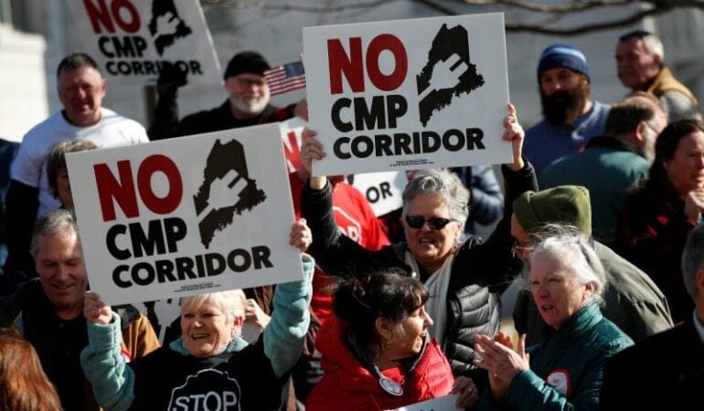
Una batalla legal de cuatro años sobre una línea de transmisión de 232 kilómetros que transportaría energía hidroeléctrica desde Quebec a Massachusetts ha sido representativa de la pelea despiadada sobre el uso del suelo. Los grupos de conservación dijeron que las tuberías amenazaban las áreas naturales en Maine, donde la mayor parte de la línea se construiría, lo que incitó a una votación en contra del proyecto a nivel nacional, a pesar de que ya se lo había autorizado. Recientemente, un juez dictaminó que la construcción podía reanudarse.
Los defensores se quejaron de que la oposición había sido financiada y motivada por un servicio público de gas natural rival para bloquear la competencia. Joseph Curtatone, presidente del Consejo de Energía Limpia del Noreste, dijo que esperaba que la decisión de la corte “ponga fin a los intentos egoístas de sabotear este proyecto financiados por empresas”. Construir el proyecto como se planificó, dijo, eliminaría más de tres millones de toneladas métricas de carbono por año y proporcionaría US$ 200 millones en modernizaciones urgentemente necesarias para la red eléctrica.
“Es un trabajo esencial en nuestro esfuerzo por electrificar todo a fin de evitar los peores efectos del cambio climático Si no se moderniza la red, no podemos distribuir electricidad para calentar las bombas y los vehículos eléctricos. Estos son los tipos de zancadas que tenemos que dar después de décadas de progreso mínimo en materia de acción climática”, dijo. “Si estamos luchando con uñas y dientes por eliminar tres millones de toneladas de CO² con energía de bajo costo, nunca vamos a alcanzar la neutralidad de carbono”.
En el libro Superpower (Superpoder), la autora Russell Gold hizo una crónica del intento, finalmente en vano, por parte del empresario de Houston Michael Skelly de obtener la aprobación de una línea de transmisión para conectar los parques eólicos en Oklahoma con la red de Tennessee, que se volvió emblemática por la oposición de la comunidad acompañada de los políticos (Gold 2020). Pero se sigue repitiendo el mismo problema. Pasaron 18 años hasta que las autoridades federales aprobaron una transmisión de 1.178 kilómetros para transportar energía limpia desde el propuesto parque eólico TransWest de 700 turbinas en unas tierras de haciendas en Wyoming hasta viviendas y negocios en California. El proyecto interestatal requirió múltiples aprobaciones en virtud de la Ley Nacional de Protección Medioambiental (National Environmental Protection Act, NEPA), con una examinación detallada de los impactos sobre la flora y la fauna, incluido el urogallo de las artemisas.
Turbinas eólicas en el estado de Washington. Crédito: Ryan J Lane vía E+/Getty Images.
Las objeciones a la infraestructura verde han evocado batallas pasadas sobre las especies en peligro, sitios sagrados y otras tierras de valor cultural. El proyecto Greenlink West, una línea de transmisión de 760 kilómetros a lo largo de Nevada, está siendo blanco de críticas porque puede afectar los fósiles de colmillos de mamut lanudo.
La ironía no pasa desapercibida para muchos de que leyes medioambientales aprobadas en la década de 1970 para combatir la contaminación desenfrenada ahora se están utilizando para luchar contra proyectos de energía renovable que frenarán el cambio climático. La litigación medioambiental está amenazando una gama amplia de iniciativas beneficiosas para el medioambiente en el país, desde la vivienda densa hasta bicisendas y tarifas por congestión.
“Soy ambientalista, lo que significa que tengo experiencia en decir no. Es lo que hacemos”, escribió Bill McKibben en su ensayo para Mother Jones titulado “Yes in Our Backyards” (Sí en nuestros patios) (McKibben 2023). Las décadas de activismo de McKibben incluyen luchas exitosas contra las tuberías de combustibles fósiles de Keystone XL. “Pero ahora estamos en un momento bisagra, en el que resolver nuestros mayores problemas, medioambientales pero también sociales, implica que debemos decir sí a algunas cosas . . . Una forma puede ser retroceder un poco y pensar en un plazo apenas más largo”.
Sin ningún sentido de un gran plan o razonamiento, y ambientalistas divididos (un bando que dice que siempre deben considerarse los impactos sobre el medioambiente, y otro que dice que no habrá ningún hábitat silvestre en funcionamiento o especies prosperando si no se detiene el cambio climático), los proyectos de energía renovable se están viendo cada vez más como lo que el profesor de Harvard Alan Altshuler llamó en inglés LULU: “usos del suelo localmente indeseados”, como cárceles o vertederos
Recientemente, surgieron diversas soluciones para superar este punto muerto, entre ellas la legislación que se introdujo este mismo año.
Se necesitan por lo menos tres pasos para implementar infraestructura de energía limpia de forma eficaz y adecuada, dice Patrick Welch, analista del grupo de estrategias climáticas del Instituto Lincoln de Políticas de Suelo: reforma de los permisos a nivel federal, cambios en la regulación local, y más planificación estratégica y creativa.
“En muchas instancias, existen problemas genuinos con relación a los emplazamientos propuestos para proyectos de energía hidroeléctrica, eólica y solar, ya sea asociados a temas de escorrentía de aguas pluviales, otros impactos sobre ecosistemas importantes o apropiaciones de tierras nuevas en suelos de comunidades indígenas”, dijo Welch. “Debemos ser más estratégicos y creativos. Cosas como la coubicación de paneles solares en espacios de estacionamiento y terrazas o derechos de paso interestatales, en lugar de despojar bosques, son soluciones buenas”.
La iniciativa Derechos Renovables del Lugar (Site Renewables Right) de The Nature Conservancy, que identifica lugares apropiados para la energía solar y eólica en el centro de los Estados Unidos al trazar un mapa de los factores, incluido el impacto medioambiental y la producción agrícola, es un buen ejemplo de cómo intentar encontrar soluciones factibles, añadió Welch. Otro es el estudio del condado de Baltimore sobre el emplazamiento de los paneles solares, que identificó alrededor de 14.000 hectáreas de lugares potenciales óptimos para la energía solar en terrazas, espacios de estacionamiento y suelo degradado (Minnemeyer y Wiggans, 2020).
Instalador de paneles solares en Lowell, Massachusetts. Crédito: Jerry Monkman/EcoPhotography.
Pero, incluso con emplazamientos más adecuados, expresó Welch, las regulaciones de permisos de uso del suelo locales pueden entorpecer el paso. “Ambos bandos han sabido por décadas que NEPA y la telaraña de permisos asociada son responsables de los retrasos innecesarios y extensos. Hoy en día, la crisis climática suma una urgencia nueva a ese debate. Las regulaciones locales también deben permitir el emplazamiento adecuado de infraestructura de energía renovable”.
A muchos, la coordinación federal, que rememora el establecimiento más intencional de infraestructura en la primera mitad del siglo XX, les pareció un primer paso obvio. Esta primavera, el senador de los Estados Unidos Sheldon Whitehouse (D-RI) y el representante de los Estados Unidos Mike Quigley (D-IL) introdujeron la Ley de Optimización de la Transmisión Interestatal de Electricidad (SITE Act), que establecería una autoridad nueva de emplazamiento federal en la Comisión Federal Reguladora de Energía (Federal Energy Regulatory Commission) para facilitar el proceso de construcción de líneas de transmisión de alto voltaje y largo alcance.
“Si no construimos más líneas de transmisión de largo alcance, gran parte de la energía limpia de bajo costo que recibimos en línea simplemente no podrá llegar a los hogares y las empresas que la necesitan”, afirmó la Casa Blanca cuando se presentó la ley. El objetivo es mejorar la confiabilidad, modernizar la infraestructura de la red decrépita del país, y reducir las emisiones, a la vez que se establece un “equilibrio responsable entre las necesidades y las preferencias locales”, dijo.
Existe acción a escala nacional y regional. Después de las críticas de que las autoridades reguladoras estatales dieron muchas vueltas en torno a la energía limpia, el gobernador de Massachusetts, Maura Healey nombró a comisionados expertos en clima para el Departamento de Servicios Públicos del estado, y estableció dos comisiones nuevas, una para revisar el emplazamiento y los permisos de la energía limpia, y otra para coordinar los desarrollos eólicos trasnacionales.
En el estado de Washington, hace poco, el gobernador Jay Inslee firmó un proyecto de ley que exige la planificación a largo plazo por parte de los servicios públicos y autoriza que los proyectos de transmisión más grandes puedan avanzar en el proceso de emplazamiento optimizado del país. Bonneville Power Administration (BPA), que gestiona la energía hidroeléctrica de 31 represas federales en el noroeste, propuso algunas mejoras al sistema, que, de concretarse, ayudarán a aumentar la capacidad de transmisión.
El mercado de electricidad se estructura de forma diferente en el noroeste del Pacífico que en California y otros estados, lo que dificulta mucho más la planificación y coordinación, dijo Emily Moore, directora del programa para el Clima y la Energía del Sightline Institute. Washington y Oregón tienen planes de acción climática asertivos para cambiar a la energía limpia, pero incluso si todos los servicios públicos concuerdan en hacer el cambio mañana, la red no podría soportar la carga, dijo, así que cientos de proyectos de energía solar y eólica están languideciendo.
“En un mundo ideal, tendríamos en claro qué cantidad de transmisión adicional se necesita . . . y dónde iría, así que podríamos empezar a construirla antes de que sea demasiado tarde”, dijo. “Pero la planificación, al menos en nuestra región, es ampliamente reactiva, no proactiva. Cambiar eso aquí demandará nuevos niveles de coordinación entre BPA, los servicios públicos individuales, los reguladores y los gestores de políticas”.
Cuando los proyectos de energía renovable o las líneas de transmisión se presentan por primera vez al público, los desarrolladores deberían practicar una mayor participación de las partes interesadas, dijo Josh Hohn, director de la empresa de diseño urbano Stantec. Hohn incita a los coordinadores de proyectos a ayudar a las personas a visualizar lo que realmente se propone “antes de dar rienda suelta a la imaginación”.
Fomentar el consenso sobre la infraestructura para la energía limpia es particularmente desafiante, en parte, porque los problemas de uso del suelo son muy locales, pero se vinculan al problema mundial del cambio climático, lo que exige conceptualizar prioridades, a veces, de formas que van en contra de la intuición. Por ejemplo, parece atroz que se eliminen árboles para hacer espacio para los paneles solares. Pero, según un ecologista de bosques, hacerlo, en realidad, reduce más las emisiones de carbono después de un período que dejar los árboles en el lugar (Canham 2021).
La tecnología también está avanzando a pasos agigantados, la dimensión de uso del suelo de la energía limpia podría volverse menos onerosa. Las excavaciones geotérmicas implican menos suelo, a pesar de su semejanza con las torres de perforación que han manchado el paisaje desde principios del siglo pasado. Las baterías están mejorando, lo que permite que la energía limpia se almacene. Y existe la noción del megaproyecto de energía solar, que consolida todos los paneles solares en uno o dos lugares apartados, como un rincón del desierto del Sahara. Si hacemos un cálculo, una sola parcela de 69.000 kilómetros, 1,2 por ciento del desierto del Sahara, cubierta con paneles solares podrían dar electricidad a todo el mundo (Moalem 2016).
En un nivel más conceptual, McKibben, que fundó la organización Third Act para reclutar a boomers ancianos preocupados por el cambio climático, pidió un cambio en la forma de pensar a la hora de analizar la infraestructura para la energía limpia. En lugar de verla como algo feo, sugiere, podríamos apreciar cómo está ayudando al planeta a dejar los combustibles fósiles y los grandes beneficios económicos que tiene a la vez. “Es otro tipo de belleza”, dijo en una entrevista, a pesar de que reconoció que las personas están acostumbradas a juzgar los paisajes por medio de indicadores más convencionales.
Aún queda por ver si tal reconceptualización puede suceder. Pero es evidente que la relación de las personas con el suelo se convirtió en un elemento clave de la transición hacia la energía limpia. Ante todo, este es un momento propicio para una política de suelo a consciencia, con el futuro del planeta que pende de un hilo, dijo Patrick Welch del Instituto Lincoln.
“Dada la escala y la urgencia necesaria para este despliegue masivo de infraestructura nueva, existe un riesgo significativo de lo que hacemos de modo que conduzca a consecuencias serias no intencionadas”, expresó Welch. “Así que debemos ser conscientes y estratégicos, pero no al punto de la inacción”.
Anthony Flint es miembro sénior del Instituto Lincoln de Políticas de Suelo, conduce el ciclo de pódcasts Land Matters y es editor colaborador de Land Lines.
Imagen principal: Manifestantes marchan en contra de una línea de transmisión que atravesará Maine para transportar energía hidráulica desde Quebec hasta Massachusetts. Crédito: AP Photo/Robert F. Bukaty
Referencias
Bessette, Douglas L. y Sarah B. Mills. 2021. “Farmers vs. Lakers: Agriculture, Amenity, and Community in Predicting Opposition to United States Wind Energy Development”. Energy Research & Social Science. Vol. 72. Febrero. https://www.sciencedirect.com/science/article/abs/pii/S2214629620304485.
Crawford, Jessica, Douglas L. Bessette y Sarah B. Mills. 2022. “Rallying the Anti-Crowd: Organized Opposition, Democratic Deficit, and a Potential Social Gap in Large-Scale Solar Energy”. Energy Research & Social Science. Vol. 90. Agosto. https://www.sciencedirect.com/science/article/abs/pii/S2214629622001013.
EIA (US Energy Information Administration). 2016. “U.S. Electric System Is Made Up of Interconnections and Balancing Authorities”. Today in Energy. 20 de julio. https://www.eia.gov/todayinenergy/detail.php?id=27152.
Larson, Eric, Chris Greig, Jesse Jenkins, Erin Mayfield, Andrew Pascale, Chuan Zhang, Joshua Drossman, Robert Williams, Steve Pacala y Robert Socolow. 2020. “Net-Zero America: Potential Pathways, Infrastructure, and Impacts”. Interim report. Princeton, NJ: Princeton University. 15 de diciembre. https://environmenthalfcentury.princeton.edu/sites/g/files/toruqf331/fil….
Riofrancos, Thea, Alissa Kendall, Kristi K. Dayemo, Matthew Haugen, Kira McDonald, Batul Hassan y Margaret Slattery. 2023. “Achieving Zero Emissions with More Mobility and Less Mining”. University of California-Davis Climate and Community Project. https://www.climateandcommunity.org/more-mobility-less-mining.
Susskind, Lawrence, Jungwoo Chun, Alexander Gant, Chelsea Hodgkins, Jessica Cohen y Sarah Lohmar. 2022. “Sources of Opposition to Renewable Energy Projects in the United States”. Energy Policy. Vol. 165. Junio. https://www.sciencedirect.com/science/article/pii/S0301421522001471.
Mayor’s Desk
Vivienda y esperanza en Cincinnati
Por Anthony Flint, July 31, 2023
SHARE
Aftab Pureval, electo en 2021, está haciendo historia como el primer alcalde asiático estadounidense de Cincinnati. Se crio en el suroeste de Ohio, fue hijo de primera generación de estadounidenses y trabajó en una juguetería cuando estaba en la secundaria. Después de graduarse en la Facultad de Derecho de la Universidad Estatal de Ohio, Pureval ejerció varios cargos en la comunidad jurídica, entre ellos, abogado en Procter & Gamble, antes de ingresar al servicio público. Ejerció como secretario del Tribunal del condado de Hamilton de 2016 a 2021, y fue el primer demócrata en ocupar dicha oficina en más de 100 años. Pureval reside en el norte del barrio de Clifton, en Cincinnati, con su esposa y sus dos hijos. A principios de este año, habló con nuestro miembro sénior, Anthony Flint, para el pódcast Land Matters. Esta transcripción se editó por motivos de espacio y claridad.
Aftab Pureval: Solo para brindar un poco más de contexto, Cincinnati es una de las antiguas ciudades industriales. Tenemos una larga y orgullosa tradición de ser el destino final del Ferrocarril Subterráneo. Fuimos la puerta de entrada a la libertad para muchos esclavos que escapaban de esa experiencia horrible. Tenemos muchos vecindarios históricos, muchas construcciones históricas, y tenemos mucha infraestructura antigua y viviendas unifamiliares antiguas, lo que, sumado al hecho de que somos una ciudad asequible en el contexto nacional, nos convierte en el blanco principal de los inversionistas institucionales.
Desafortunadamente, Cincinnati figura en lista nacional tras lista nacional en cuanto a la tasa de aumento de los alquileres. El factor principal que impulsa esta situación proviene de esos inversionistas, que no son de la ciudad y no tienen ningún interés en el bienestar de Cincinnati y sus inquilinos, y que acaparan todas las viviendas unifamiliares baratas, no hacen nada para invertir en ellas, pero duplican o triplican los alquileres de un día para el otro. La ciudad está haciendo muchas cosas a través de litigaciones, por medio de la aplicación del código . . . para hacerles saber que no estamos jugando. Si vas a tener un comportamiento depredador en nuestra comunidad, no te defenderemos.
Además, hemos tomado medidas en una etapa temprana para prevenir que esto suceda al asociarnos con The Port . . . Cuando muchas propiedades salieron a la venta porque un inversionista institucional las incluyó en un bloque de venta, The Port gastó US$ 14,5 millones para comprar más de 190 viviendas unifamiliares, y superó las apuestas de otros 13 inversionistas institucionales . . . Durante el año pasado, The Port trabajó para modificar esas propiedades a fin de que cumplan con los requisitos [y de encontrar] compradores calificados, a menudo, ciudadanos que están trabajando en la pobreza o de clase media-baja, que jamás han poseído una vivienda.
Una de las casi 200 casas compradas por el Puerto de Cincinnati como parte de un esfuerzo por preservar la asequibilidad y brindar oportunidades de propiedad de vivienda a los residentes locales. Crédito: Autoridad de Desarrollo del Puerto de Cincinnati.
Este año estamos trabajando en tres de las 194 de esas viviendas disponibles para la venta. Es un gran éxito en desde donde se lo mire . . . pero es solo una herramienta en la que The Port y la ciudad están trabajando para aumentar la capacidad de pago de la vivienda en todos nuestros barrios.
AF: ¿Qué aprendió de esto que pueda transferirse a otras ciudades? Se requiere mucho capital para superar la apuesta de un inversionista institucional.
AP: Es verdad, se requieren muchos fondos. Por eso es que necesitamos más flexibilidad del gobierno federal y del estatal para brindarles a las municipalidades las herramientas necesarias para evitar que esto suceda en una primera instancia. Ahora, una vez que un inversionista institucional clava sus garras en una comunidad, no hay mucho que la ciudad pueda hacer para responsabilizarlo.
Como hemos visto, la mejor estrategia es comprar grandes cantidades de propiedades en una etapa temprana. Muchas ciudades reciben muchos dólares del gobierno federal por medio del Plan de Rescate Estadounidense (ARP, por su sigla en inglés). Hemos usado gran parte de los dólares del ARP no solo para que el dinero llegue a las manos de las personas que más lo necesitan, lo que es de vital importancia en este momento, sino también para asociarnos a otras alianzas público-privadas o a The Port, a fin de proporcionarles los recursos necesarios para comprar grandes cantidades de suelo y conservarlo.
Este es un momento único para las ciudades que tienen más flexibilidad [con] los recursos que provienen del gobierno federal. Incentivaría a todos los alcaldes y consejos a que realmente piensen de forma crítica sobre el uso de los fondos, no solo en el corto plazo, sino también en el largo plazo, para enfrentar a algunas de estas fuerzas macroeconómicas.
Leaders in Cincinnati are striving to balance growth and affordability. Credit: StanRohrer via iStock/Getty Images Plus.
AF: Cincinnati se convirtió en un destino de residencia más atractivo, y la población aumentó ligeramente tras años de recesión. ¿Considera a Cincinnati como un refugio del clima o de la pandemia? ¿Qué implicaciones tiene este crecimiento?
AP: Lo que amo de mi trabajo como alcalde es que no me centro necesariamente en los próximos dos o cuatro años, sino en los próximos 100 años. En este momento, estamos atravesando un cambio de paradigma debido a la pandemia. La forma en la que vivimos, trabajamos y jugamos está cambiando drásticamente. El trabajo remoto está transformando por completo nuestro estilo de vida económico en todo el país, pero, en particular, aquí en el Medio Oeste.
No me cabe duda de que debido al cambio climático, debido al aumento del costo de vida en la costa, habrá una migración hacia el interior. No sé si será entre los próximos 50 o 75 años, pero sucederá. Estamos viendo cómo grandes empresas toman decisiones con base en el cambio climático. Tan solo a dos horas al norte de Cincinnati, Intel está invirtiendo US$ 200.000 millones para crear la planta semiconductora más amplia del país, atraída por nuestro acceso a agua dulce y la resiliencia climática de nuestra región.
Ahora, no me malinterpreten: el cambio climático nos afecta a todos . . . pero en Ohio y Cincinnati, no observamos los incendios forestales, las sequías, los huracanes, los terremotos, la erosión costera que vemos en otras partes del país, lo que nos hace un refugio seguro del cambio climático no solo para la inversión privada sino también para las personas.
El alcalde Pureval, a la derecha, habla en una celebración de Findlay Market, el mercado público en funcionamiento continuo más antiguo de Ohio. Crédito: Cortesía de Aftab Pureval.
Cincinnati está creciendo, en parte, porque, en este momento, nuestra economía se está expandiendo, pero creo que realmente veremos un crecimiento exponencial en las próximas décadas debido a estos factores masivos que empujan a la gente hacia el interior del país. Para asegurarnos de que en el futuro las inversiones y el crecimiento demográfico no desplacen a nuestros residentes actuales, tenemos que estabilizar el mercado ahora y prepararnos para tal crecimiento..
AF: ¿Cuáles son los cambios en el uso del suelo y las mejoras de transporte en las que se está concentrando con relación a esto?
AP: Si queremos que esto salga bien, debemos hacer una revisión y una reforma integrales de nuestras políticas. Nos estuvimos reuniendo con las partes interesadas para [explorar cómo] se vería una Cincinnati moderna. Creo que se vería como un barrio denso y diverso por el que se podría caminar, y tendría un buen transporte público e inversiones en arte público. Ahora mismo, la zonificación de la ciudad de Cincinnati no está promoviendo esos tipos de barrios. Cerca del 70 por ciento de nuestra ciudad se zonificó exclusivamente para uso unifamiliar, lo que representa una restricción artificial en la cantidad de oferta que podemos crear. A su vez, esto está aumentando los alquileres y los impuestos a la propiedad de forma artificial, lo que está haciendo que muchos de nuestros antiguos residentes, incluso aquellos que poseen sus viviendas, se vean desplazados.
Si nos tomamos con seriedad la desconcentración de la pobreza y la desegregación de nuestra ciudad, entonces tenemos que analizar las prohibiciones de unidades multifamiliares. Tenemos que analizar los requisitos de estacionamiento para empresas y viviendas. Tenemos que considerar el desarrollo orientado al transporte público junto con nuestras líneas de tránsito rápido de autobuses. Tenemos que considerar oportunidades creativas para crear más viviendas como unidades accesorias, pero nada de esto es fácil . . . Tengo la convicción de que podemos lograr algunos cambios sustanciales para nuestro código de zonificación a fin de propiciar una mayor capacidad de pago, fomentar más transporte público y, simplemente, ser una ciudad más ecológica. En este punto, asumimos el compromiso de que, cuando estén disponibles, solo compraremos vehículos para la cuidad que sean eléctricos. Tenemos la granja solar administrada por una ciudad más grande de todo el país, lo que contribuye significativamente a nuestro consumo de energía.
AF: Un poco de esto es volver al futuro, porque la ciudad tenía tranvías. ¿Tiene la sensación de que existe una apreciación de eso, de que esos tiempos, en realidad, hicieron que la ciudad funcione mejor?
AP: La ciudad solía ser densa, solía tener tranvías increíbles, transporte público, y luego, lamentablemente, las ciudades, no solo Cincinnati sino en todo el país, vieron una disminución constante de la población, y una pérdida de residentes desplazados a los suburbios. Ahora las personas quieren regresar a la ciudad, pero tenemos el trabajo duro de deshacer lo que muchas ciudades intentaron hacer, que fue crear vecindarios de suburbios dentro de una ciudad para incentivar que la gente de los suburbios regrese. Se trata de deshacer un poco el pasado a la vez que nos concentramos en lo que supo existir.
Tranvías en Fountain Square de Cincinnati durante la Primera Guerra Mundial. Crédito: Metro Bus vía Flickr CC BY 2.0.
AF: ¿Qué le preocupa más sobre este tipo de transiciones, y qué identifica como el problema principal que enfrentan las personas de ingresos bajos y comunidades de color en Cincinnati?
AP: Desplazamiento. Si no podemos ser una ciudad asequible para sus residentes, estos se irán, lo que es perjudicial en muchos aspectos. Si la ciudad no crece, una ciudad de nuestra magnitud y con nuestra ubicación dentro del país, entonces muere, muere rápido. Las ciudades de magnitudes como la nuestra tienen que crecer, y para que esto ocurra, no solo debemos reunir talento, sino también preservar a las familias y las comunidades antiguas que han estado aquí desde el primer momento..
Ninguna ciudad del país descubrió una forma de crecer sin desplazamiento. Los factores del mercado, los factores económicos son tan profundos y es tan difícil influir sobre estos, y los recursos de la ciudad son tan limitados, que es realmente difícil . . . A menudo, supongo que me frustro por no contar con suficientes recursos, suficiente autoridad para tener un impacto significativo en las fuerzas macroeconómicas que están ingresando a la ciudad. Ya que, si alcanzamos nuestro sueño, que es más inversión, más crecimiento, esto conllevará consecuencias negativas, y es realmente difícil de gestionar ambos..
AF: La página web de la alcaldía dice que Cincinnati está bien posicionada para ser líder en el cambio climático localmente y en el exterior. ¿Qué cree que la ciudad tiene para ofrecer que hace que se distinga en términos de acción climática?
AP: Todas nuestras iniciativas políticas se analizaron con dos lentes. El primer lente es el de la equidad racial y el segundo, el del clima. Esto se aplica a todo lo que hacemos, ya sea nuestra valuación de la silvicultura urbana, el análisis de un mapa de calor de nuestra ciudad o las inversiones en árboles no solo para limpiar el aire sino también para enfriar nuestros barrios, [o] nuestras inversiones en biocarbón. Somos una de las únicas tres ciudades en todo el mundo que recibieron un copioso subsidio por parte de Bloomberg Philanthropies para seguir innovando en el mundo del biocarbón, que es un subproducto de la quema de madera, que es un imán de carbono increíble que ayuda con la escorrentía de aguas pluviales a la vez que captura el carbono del aire.
Últimamente, las empresas y personas que miran hacia el futuro consideran al cambio climático en ese futuro. Si busca una ciudad que sea resiliente ante el cambio climático y además realice inversiones cuantiosas en tecnología climática, entonces Cincinnati es el destino indicado para usted.
Anthony Flintes miembro sénior del Instituto Lincoln de Políticas de Suelo, conduce el ciclo de pódcasts Land Matters y es editor colaborador de Land Lines.
The Lincoln Institute of Land Policy invites proposals for original research on land policies and urban development in Latin America and the Caribbean. Our objective is to understand how land policies are overcoming—or can overcome—systemic challenges to sustainable development in the region, including housing affordability and informality, spatial segregation, fiscal autonomy, and climate change. We need to think holistically to produce structural changes to address these challenges, so we are seeking to shed light on current policy debates across the region on key research areas of interest to the Lincoln Institute. These areas include the implementation of land-based financing instruments for infrastructure finance and fiscal stability, approaches to informal settlements’ upgrading and regularization, policies to reduce housing deficits, and enabling nature-based solutions for climate action.
Application guidelines and proposal submissions are also available in Spanish and Portuguese.
Details
Submission Deadline
January 15, 2024 at 11:59 PM
Keywords
Adaptation, Climate Mitigation, Housing, Inequality, Informal Land Markets, Infrastructure, Land Market Regulation, Land Use, Land Use Planning, Land Value, Municipal Fiscal Health, Planning, Property Taxation, Public Finance, Public Policy, Urban Development, Urban Upgrading and Regularization, Value Capture, Water
Requests for Proposals
Research on Municipal Fiscal Health and Land Policies
The submission deadline has been extended from January 29 to February 5, 2024.
The Lincoln Institute of Land Policy invites proposals for original research that can be applied to address the challenge of promoting the fiscal health of municipal governments in a range of contexts and institutional settings across the world. We are particularly interested in research that explores the ways sound urban planning, land-based taxation, and economic development combine with disciplined financial management to promote prosperous, sustainable, equitable, and fiscally healthy communities.
Research proposed should examine some of the most pressing questions that local officials around the world are confronting in the fiscal policy arena, with an emphasis on the implications for local land policy and planning decisions.
Details
Submission Deadline
February 5, 2024 at 11:59 PM
Keywords
Development, Economic Development, Housing, Infrastructure, Land Use Planning, Land Value, Land Value Taxation, Land-Based Tax, Local Government, Municipal Fiscal Health, Property Taxation, Public Finance, Public Policy, Urban Development, Value Capture, Value-Based Taxes, Zoning
La caja de herramientas de la naturaleza
Marismas salinas, hongos y otros héroes climáticos olvidados
El cambio climático ya no está tocando a la puerta: este verano, la tiró abajo. Los incendios forestales destrozaron más de 13 millones de hectáreas de selva en la peor temporada de incendios de la historia de Canadá. Vermont quedó inundada a causa de una tormenta inusitada por segunda vez en 12 años, mientras otro diluvio ocasionó cinco muertes fuera de Filadelfia. La temperatura en Phoenix alcanzó los 43 grados Celsius durante 31 días consecutivos, y en ningún momento bajó de los 32 grados durante más de dos semanas consecutivas. Y mientras los episodios de inundaciones, incendios y calores feroces estallaban en todo el planeta, transitábamos el día más caluroso registrado en la historia (un récord mundial que se superó de inmediato al día siguiente y, de nuevo, al día siguiente), en lo que, según los científicos, fue probablemente el mes más caluroso en la Tierra en 120.000 años.
Dada la urgencia de la crisis climática, cualquier solución viable para limitar un mayor calentamiento y para que nuestras economías dejen de depender de los combustibles fósiles merece ser explorada. Esta situación alarmante demanda avances tecnológicos, por supuesto; de hecho, la tecnología ha aliviado mucho sufrimiento humano, y es tentador depositar todas nuestras esperanzas en ella, como los fanáticos de deportes desesperados que miran expectantes al jugador estrella de su equipo para ver si logra solo una jugada espectacular más en el tiempo de descuento.
Pero no podemos desestimar la importancia de permitir y promover que la naturaleza sane sus propios ecosistemas como parte de nuestra estrategia climática.
A menudo se alaba a los árboles por la gran cantidad de pequeñas maravillas que brindan, sobre todo en áreas urbanas, ya que refrescan las calles, limpian el aire y reducen la escorrentía de las tormentas, a la vez que extraen el dióxido de carbono de la atmósfera. Pero ¿cuántas personas saben que los hongos silvestres microscópicos procesan el doble del carbono que emite los Estados Unidos cada año? ¿O que una marisma salina puede capturar 10 veces más carbono por hectárea que un bosque? ¿O que restaurar incluso una pequeña fracción de poblaciones de bisontes en diferentes partes de la llanura de los Estados Unidos podría ayudar a que los pastizales absorban más carbono que todo el que emite Gran Bretaña en un año?
Estas no son curas milagrosas para la crisis climática, por supuesto; ninguna de estas herramientas reducirá el cambio climático por sí sola sin una disminución drástica del uso de combustibles fósiles. Pero todas son estrategias de riesgo bajo, sorprendentemente poderosas y relativamente simples que podemos utilizar con mayor frecuencia y en más lugares. Después de todo, tanto un costoso taladro inalámbrico como un destornillador de cinco dólares pueden ayudarte a construir algo, pero solo si te pones a trabajar con ellos.
La magia de las marismas
Cientos de millones de personas de todo el mundo viven cerca de una marisma salina, o un ecosistema costero similar con manglares y pasto marino. Estos santuarios costeros ofrecen una belleza tranquila y atraen abundante vida silvestre. Además, absorben la energía del agua de las inundaciones y de las olas durante las tormentas, lo que reduce el daño a las comunidades adyacentes en hasta un 20 por ciento. Pero muchas personas no se dan cuenta de que estos modestos humedales alimentados por las mareas también se encargan de captar carbono a un ritmo sorprendente: de 10 a 40 veces más rápido que una selva.
Hay dos razones por las que las marismas salinas, los manglares y las praderas de pastos marinos son sumideros de carbono tan poderosos. Una es que su vegetación crece muy rápido, dice Hilary Stevens, gerenta de resiliencia costera de Restore America’s Estuaries (RAE). “Se produce mucha fotosíntesis, mucha captura de dióxido de carbono de la atmósfera”, explica.
Pero la magia real de la marisma es su suelo húmedo y salino. Cuando la vegetación muere, cae al fondo de la marisma y se entierra en una red de raíces y sedimento, donde permanecerá saturada con agua salada de forma indefinida. Dicho medioambiente anaeróbico ralentiza, o incluso detiene, el proceso de descomposición, lo que permite que el carbono de las plantas se quede almacenado en el suelo por cientos o miles de años. Esta bóveda bajo agua se conoce como “carbono azul”.
El suelo salino y húmedo de las marismas costeras puede almacenar carbono por miles de años. Crédito: Velvetfish vía iStock/Getty Images Plus.
Si bien las selvas también son excelentes capturadoras de carbono, dice Stevens, existe más probabilidad de que lo liberen, por medio de eventos que abarcan desde incendios forestales hasta la descomposición. Pero el carbono en el suelo de las marismas “puede permanecer allí por siglos si dicha área se mantiene inundada o inalterada”.
Por supuesto, todo es relativo cuando existen personas alrededor. Solo Estados Unidos pierde un estimado de 32.000 hectáreas de humedales costeros cada año debido a la combinación de la urbanización y el aumento del nivel del mar. Incluso muchas marismas que sobrevivieron se drenaron por medio de acequias con el paso de los años, lo que permitió que el aire alcance el suelo que había estado sumergido por mucho tiempo, y convirtió los poderosos sumideros de carbono en emisores permeables de CO2.
“Si alteras un suelo inundado, si permites que se drene, ya sea porque lo rellenas, le excavas acequias, le levantas un terraplén, lo drenas, lo conviertes para uso agrícola o lo pavimentas y construyes un estacionamiento, se corre riesgo de que todo ese material orgánico vuelva a liberarse a la atmósfera”, dice Stevens. De esa manera, el carbono que se capturó durante siglos puede escaparse bastante rápido. Por eso, desde un punto de vista climático, es crucial evitar que se sigan perdiendo humedales costeros sanos.
Es un desafío que crece a medida que se acelera el aumento del nivel del mar. A veces, las marismas salinas pueden migrar hacia tierras altas a medida que los mares invaden el continente, dice Cynthia Dittbrenner, directora de recursos costeros y naturales de la organización de conservación con sede en Massachusetts, The Trustees, pero solo si hay espacio para eso, y los muros y las rutas de la urbanización humana suelen imposibilitarlo. Y, a pesar de que son bastante buenas para adaptarse a los mares que crecen lentamente (porque una marisma salina saludable crece en altura de forma natural cada año ya que sus pastos mueren y se acumulan en la base y las afluencias diarias de la marea proporcionan sedimento nuevo), los científicos temen que el proceso natural de acumulación no pueda sostenerse con el ritmo acelerado y antinatural de aumento del nivel del mar debido al cambio climático generado por las personas.
De hecho, muchas de las marismas que nos quedan no se encuentran precisamente en buen estado.
En Nueva Inglaterra, por ejemplo, los agricultores coloniales consideraban a las marismas salinas como una fuente de heno para el ganado y los caballos, y se dieron a la tarea de drenarlas para facilitar la cosecha. A la fecha, la mayoría de las marismas de la región aún se encuentran rodeadas de acequias excavadas por el hombre cientos de años atrás. Con el tiempo, las acequias descuidadas por muchos años se atascaron, lo que creó piletas de agua estancada y promovió que las cuadrillas de prevención de mosquitos del siglo XX las excavaran una vez más. Pero una marisma drenada no aumenta de altura como debería; de hecho, desciende, porque la materia orgánica del suelo empieza a descomponerse más rápido ya que interactúa con el aire.
“Un legado de 300 años de nosotros excavando acequias en las marismas hizo que bajara el nivel freático y que su suelo hoy esté expuesto al oxígeno”, dice Dittbrenner. “Están oxigenadas, se están descomponiendo rápido y se están hundiendo . . . así que, tenemos que reparar la hidrología para restaurar el proceso natural”.
Existen formas simples y rentables de restaurar las marismas salinas drenadas con acequias. Un método, que probó el Servicio de Pesca y Vida Silvestre de los Estados Unidos, es cortar el pasto de las marismas a lo largo de la orilla de una acequia, rastrillar el heno hacia el interior de la zanja, y asegurarlo al fondo con cuerdas y estacas. “Cuando las mareas ingresan, ese heno ralentiza el agua y fomenta que el sedimento se retire”, dice Dittbrenner, y así se rellena la acequia lentamente. “Y si repites este procedimiento durante una serie de tres o cuatro años, habrás llenado la acequia, y podrá volver a crecer heno de marisma salina”, y el agua de la marea perdura por más tiempo del que lo haría de forma natural.
The Trustees implementó esa técnica en 34 hectáreas que gestiona en la Great Marsh al norte de Boston, y los resultados fueron tan prometedores que la organización aseguró fondos (y obtuvo permisos difíciles de conseguir), para expandir los esfuerzos de restauración en 515 hectáreas. El proyecto incluye suelo que es propiedad de The Trustees, un fideicomiso de suelo local, y del estado.
En lugares donde una ruta o puente ha desconectado parte de una marisma del agua del mar que ingresa, se está implementando otra posibilidad para la recuperación de las marismas. “El área que está corriente arriba de ese punto acaba siendo, básicamente, agua dulce, porque no recibe suficiente afluencia de la marea”, dice Stevens. El suelo inundado con agua dulce también libera dióxido de carbono de manera más lenta, señala, pero emite mucho metano, un gas de efecto invernadero mucho más potente, porque alberga un conjunto de microbios que no se encuentran en aguas salobres o saladas. “Si puedes recuperar el flujo de la marea hacia esas áreas, el beneficio de carbono es masivo”.
Una iniciativa de este tipo que se está poniendo en marcha es el Proyecto de Restauración del Río Herring en Wellfleet, Massachusetts, donde un dique construido en 1909 cortó el flujo de la marea hacia lo que supo ser un estuario estable durante 2.000 años. Un puente nuevo con grandes compuertas de marea permitirá que el agua del océano regrese (en un principio, de forma gradual), junto con el arenque y otros peces, sedimento de marea y pastos marinos nativos de agua salada. El proyecto restaurará 274 hectáreas de humedales de agua dulce a marismas salinas, y la Encuesta Geológica de los Estados Unidos calcula que esto reducirá las emisiones en una cifra equivalente a 2.721 toneladas métricas de carbono por año.
El Proyecto de restauración del río Herring, Massachusetts, restituirá 275 hectáreas de humedales de agua dulce a marismas salinas al instalar un puente nuevo con compuertas de marea. Crédito: USGS Photo/Sara Ernst.
Con menos espacio para migrar, las marismas “periféricas” más pequeñas y estrechas están en riesgo a causa de las crecidas de los mares. Pero pueden ‘atenuar’ bastante la energía de las olas”, dice Dittbrenner, lo que las convierte en defensas útiles contra las tormentas para las comunidades costeras. Estas marismas pueden protegerse, o incluso crearse, con métodos simples y naturales. Instalar biotroncos de coco (hechos con fibras de coco) o bolsas de red llenas de conchas de ostras a unos metros de la costa, por ejemplo, puede ayudar a proteger las marismas y a fomentar su crecimiento detrás de estas barreras. “Reduce tanto la energía de la ola que permite que el sedimento se acumule”, comenta, hasta que el pasto pueda crecer en ella. En un proyecto, dice Dittbrenner, los investigadores lograron extender un tramo de una ciénaga periférica tres metros más dentro del agua en menos de un año, usando redes de langostas viejas para reducir las olas y capturar sedimentos.
Ahora, Stevens está trabajando en un proyecto en la Costa del Golfo que usa conchas de ostras recicladas de restaurantes para construir arrecifes artificiales, lo que crea un hábitat nuevo para las ostras vivas. Además de aumentar la seguridad alimentaria para la comunidad (las ostras, señala, son una de las formas más amigables con el ambiente para cultivar proteína, que no requiere irrigación, fertilizantes ni alimento), los arrecifes crean un rompeolas para estabilizar las costas y proteger a las comunidades adyacentes.
Pero detener la pérdida continua de humedales costeros tendría el mayor impacto climático de todos. “Nos encantaría ver una mayor protección de los ecosistemas de carbono azul existentes”, comenta Stevens, junto con un enfoque de gobierno más coordinado, dos pilares del Plan de Acción Nacional de Carbono Azul de la organización Restore America’s Estuaries.
Al mismo tiempo, Stevens dice que es necesaria una reforma con respecto a los permisos, para que grupos como RAE y The Trustees puedan restaurar con mayor facilidad las marismas degradadas. Por ejemplo, puede ser difícil reutilizar los sedimentos dragados, aunque se trate de un ingrediente clave para ayudar a las marismas que están descendiendo. “Algunas de esas regulaciones, por la forma en que están redactadas, incluso impiden la restauración, porque dificultan demasiado el trabajo en la zona costera”, dice. Esas normas se establecieron con las mejores de las intenciones, añade, pero eso fue hace una década. “Y hemos aprendido mucho desde entonces”.
Hongos alimentados por la selva
Ni plantas ni animales (si bien se relacionan más con los segundos), los hongos conforman su propio reino biológico, y esto abarca a alrededor de 3,5 millones de especies diferentes. Los hongos microscópicos están en todas partes, en todo nuestro cuerpo, en las plantas, en el aire que respiramos, y sin ellos, dice Jennifer Bhatnagar, profesora adjunta de Biología en la Universidad de Boston, la mayoría de los procesos biológicos de la Tierra se terminarían. Son particularmente importantes en los bosques.
“Una de las principales funciones de dichos hongos en los bosques es la de descomponer las hojas de las plantas muertas, así como las raíces y otras partes de las plantas, y otros microorganismos muertos, y gran parte de esa actividad sucede en el suelo”, dice. Al hacerlo, liberan elementos como nitrógeno, fósforo y sulfuro de vuelta al suelo en un formato que las plantas pueden usar.
Vista microscópica del hongo micorrízico que crece en una raíz de maíz. Crédito: Servicio de Investigación Agrícola del Departamento de Agricultura de Estados Unidos (USDA, por sus siglas en inglés).
Pero existe un grupo que es particularmente crucial para la salud de los bosques: los hongos micorrícicos, que viven en las raíces de las plantas en una de las relaciones simbióticas más antiguas que se encuentran en la naturaleza.
Cuando un hongo micorrícico coloniza una planta al crecer sobre las células de sus raíces o dentro de ellas, la planta envía hasta un 30 por ciento de su carbono (en forma de azúcar, producida por medio de la fotosíntesis) desde sus hojas hasta sus raíces, para alimentar a los hongos. Para devolver el favor, “el hongo usa dicho carbono para extenderse, ingresar al suelo y absorber los nutrientes que otros hongos descomponen”, explica Bhatnagar, y se los ofrece a la planta. El carbono termina alimentando no solo a los hongos, sino también a los microbios cercanos, que ayudan a capturarlo en el suelo.
Investigadores de la Universidad de Florida y la Universidad de Virginia Occidental reunieron la colección más grande del mundo de hongos micorrícicos arbusculares. La colección se está transfiriendo a curadores nuevos en la Universidad de Kansas. Crédito: WVU Photo/Brian Persinger.
“Esta es la forma principal para que el carbono de las plantas viaje desde arriba hacia abajo del suelo en la superficie de la tierra”, dice Bhatnagar. “Es una forma realmente importante mediante la que podemos extraer el carbono de la atmósfera y ponerlo dentro de la tierra, y este puede permanecer allí por bastante tiempo”.
Un estudio publicado en junio calculó que unas sorprendentes 13,12 gigatoneladas de carbono restaurado por las plantas cada año se debe a los hongos micorrícicos, al menos temporalmente. Aún se desconoce cuánto de ese carbono permanece en la tierra a largo plazo, pero incluso la mitad de eso representaría más que las emisiones anuales equivalentes al carbono de los Estados Unidos, y los investigadores sugirieron que los hongos podrían ser esenciales para alcanzar las cero emisiones netas.
Las redes de hongos micorrícicos también pueden ayudar a impulsar la captura de carbono por encima de la tierra de los bosques. El ecologista Colin Averill, científico principal de Crowther Lab de ETH Zurich y fundador de Funga, una start-up de extracción de carbono, dice que es útil pensar sobre el medioambiente microbiano de la tierra de la forma en la que concebimos al bioma del intestino humano. “Cada uno de nosotros tiene una comunidad increíblemente biodiversa de bacterias en el intestino, y esto tiene una profunda implicancia para nuestra salud”, dice Averill, y lo mismo ocurre en los bosques.
Para aprender cómo es un microbioma silvestre saludable, él y su equipo compararon muestras de suelo de cientos de lugares de toda Europa donde los guardaparques habían estado haciéndole un seguimiento a los árboles por décadas. Observaron que la mezcla de hongos que viven en las raíces de los bosques de donde se tomaron las muestras se asociaba a una variación de tres veces en cuanto a la velocidad en que los árboles crecen. En otras palabras, Averill dice, “Podrías tener dos bosques de pinos en Europa Central, uno al lado del otro, que tienen el mismo clima, crecen en el mismo suelo. Pero si uno de ellos tiene la comunidad correcta de hongos en sus raíces, puede crecer hasta tres veces más rápido que el bosque colindante”, y extraer más carbono de la atmósfera.
Esto puede tener un impacto profundo en la reforestación de tierras que se utilizaron para fines agrícolas u otros paisajes degradados, donde, después de décadas de cultivo, pastoreo o explotación minera, dice Averill que “los microbios que viven en dicho suelo ya no se verán como los microbios de un bosque”.
Averill se asoció con una organización sin fines de lucro de Gales que estaba reforestando una pastura para ovejas abandonada a fin de realizar un experimento: agregar un puñado de suelo de un bosque saludable a algunos de los árboles jóvenes que plantaban. “Es un procedimiento que requiere muy poca tecnología”, dice. “Pero no se trata de cualquier tierra. Tiene que ser tierra de los bosques que nuestros análisis identificaron que albergan comunidades fúngicas intactas, muy productivas, biodiversas y silvestres. Y los resultados iniciales muestran que podemos acelerar la regeneración del bosque de un 30 a 70 por ciento, si reintroducimos de forma conjunta la microbiología bajo la tierra.
Experimentos similares en todo el mundo que introdujeron redes microbiológicas saludables en bosques o suelos de pastizales degradados mostraron un 64 por ciento de aumento promedio en el crecimiento de la biomasa, comenta Averill, aunque los resultados varían ampliamente. “Algunos lugares no responden, algunos responden significativamente”, añade. “Pero, básicamente, lo que estamos aprendiendo es que existe algo especial sobre la microbiología silvestre que puede perderse, y puede tener este efecto enorme si lo reintroduces”.
Permitir que la vida silvestre sea silvestre
Para obtener otra forma de acelerar el crecimiento de los bosques y la captura de carbono, recurrimos a un reino biológico diferente: el animal. Un estudio de 2023, dirigido por Oswald J. Schmitz, profesor de Ecología de la Universidad de Yale, observó que al proteger y restaurar poblaciones de especies animales, se pueden potenciar las capacidades de captura de carbono de sus respectivos ecosistemas. Esto puede aumentar la cantidad total de dióxido de carbono que se absorbe y se almacena de forma natural en unas 6,41 gigatoneladas por año en todo el mundo, o más de 6 billones de kilogramos de dióxido de carbono.
“Las personas asumen que, porque los animales son escasos en los ecosistemas, no tienen importancia para el funcionamiento de estos”, explica Schmitz. Pero la idea de las “cascadas tróficas” (en las que los depredadores, al alimentarse de herbívoros, tienen un efecto dominó en la vegetación) lo hizo pensar diferente. “Si los depredadores pueden tener un efecto profundo sobre las plantas (y sabemos que los herbívoros pueden tener un efecto profundo sobre las plantas), entonces, sin duda, también deberían tener un efecto sobre el ciclo del carbono y los nutrientes”.
Pues, lo tienen, y el impacto de carbono de las poblaciones silvestres saludables puede ser enorme en todo tipo de ecosistemas.
Al pisotear el sotobosque y esparcir las semillas, los elefantes ayudan a que los árboles densos en carbono crezcan más rápido y sean más grandes. Crédito: wanderluster a través de E+/Getty Images.
Por ejemplo, los elefantes de selva, en peligro de extinción en África Central, esparcen las semillas de los árboles y plantas leñosas, y pisan y devoran la maleza vegetal, lo que ayuda a que los árboles del dosel forestal con gran densidad de carbono crezcan más rápido y más grandes. Restaurar las poblaciones de elefantes de selva dentro de los 79 parques nacionales y áreas protegidas de la región (alrededor de 537 kilómetros cuadrados de selva tropical), podría ayudar a capturar alrededor de 13 megatoneladas de dióxido de carbono adicional por año, o 13 millones de toneladas métricas.
En el océano, los peces marinos migrantes se alimentan de algas cerca de la superficie, y su materia fecal cae al fondo del océano o nutre el fitoplancton fotosintetizador. Los peces también ayudan a que el océano capture carbono cuando liberan el exceso de sal de sus cuerpos por medio de la producción de calcita, una forma de carbonato cálcico. “La calcita es una forma de sal”, dice Schmitz, “pero también es una forma de unidad basada en carbono”. Las bolitas más duras se hunden en el fondo del océano, y no se rompen con facilidad. Los peces marinos ayudan a los océanos a absorber 5,5 gigatoneladas de dióxido de carbono por año, sin que nadie se los reconozca, y Schmitz explica que la pesca excesiva o la captura de peces en aguas más profundas podría poner en peligro esta enorme bóveda de carbono submarina.
Las nutrias marinas ayudan a que prosperen los bosques de algas absorbentes de carbono manteniendo bajo control a los erizos de mar. Crédito: Kara Capaldo a través de iStock/Getty Images Plus.
Por otro lado, los depredadores como las nutrias marinas ayudan a que los bosques de algas prosperen ya que mantienen controlados a los erizos de mar que comen algas. Los lobos grises y los tiburones crean cascadas tróficas similares en las taigas y los arrecifes de corales, donde mantienen las poblaciones de su presa herbácea más pequeña en equilibrio.
En el Ártico, la materia orgánica de la tierra no se descompone y no libera metano siempre y cuando el permafrost permanezca congelado. Los renos y los bueyes almizcleros ayudan a garantizar esto al pisotear la nieve acumulada, lo que crea una capa fría de nieve comprimida que forma una barrera aislante sobre el permafrost. Mientras tanto, solo al comer y pisotear los arbustos, ayudan a que la nieve refleje más radiación solar. “Si los animales no estuvieran allí, crecerían arbustos sobre el nivel de la nieve acumulada, el sol brillaría sobre la vegetación y , sobre todo en primavera, esa vegetación retendría la radiación solar”, dice Schmitz. “No la reflejaría de la misma forma que la nieve, y calentaría el suelo mucho más rápido”.
Según los investigadores, la restauración de las poblaciones de bisontes en partes de los estados con praderas de EUA podría compensar las emisiones de combustibles fósiles de esos estados. Crédito: Andrew Shaylor a través de E+/Getty Images.
Y en América del Norte, donde los colonizadores exterminaron más de 30 millones de bisontes que supieron deambular por las praderas, solo permanece el 2 por ciento del número original de dichos animales, confinados a alrededor del 1 por ciento de su área de distribución histórica. Según el estudio, como los grandes rebaños de bisontes de pastoreo ayudan a que los pastizales retengan el carbono en el suelo, restaurar su número en incluso una pequeña fracción del paisaje, menos del 16 por ciento de un puñado de praderas donde el conflicto para las personas sería mínimo, podría ayudar a dichos ecosistemas a almacenar unas 595 megatoneladas adicionales de dióxido de carbono por año.
Eso es más que el 10 por ciento de todo el CO2 emitido por los Estados Unidos en 2021. “Podríamos restaurar hasta dos millones de bisontes en partes de los estados de llanura donde van a tener muy poco conflicto con las personas, y al hacerlo, se va a poder capturar suficiente carbono como para compensar todas las emisiones de combustibles fósiles de los estados de llanura”, explica Schmitz.
Estos hallazgos podrían tener un impacto significativo en los esfuerzos de conservación del mar y del suelo, dice Jim Levitt, director de Red Internacional de Conservación del Suelo (ILCN, por su sigla en inglés) del Instituto Lincoln. “Esto no es algo cotidiano en una investigación de soluciones climáticas”, dice Levitt, quien no estuvo involucrado en el estudio. “Creo que esta es una información fundamental”.
En primer lugar, apunta a la necesidad de más espacios silvestres interconectados y de mayor tamaño. “No se trata solo de protección de la tierra, también se trata de administración en la conservación de extensos paisajes y grandes corredores”, dice Levitt. Los animales necesitan franjas enormes de ecosistemas intactos que sean funcionales para recuperar sus números históricos y la diversidad de sus especies, pero pueden recuperarse rápidamente, si se garantizan las condiciones correctas.
“Si le das a la naturaleza la oportunidad de reestablecerse, lo logra con una eficacia asombrosa”, dice Levitt, y destaca que muchos Bosques Nacionales de los Estados Unidos alguna vez fueron tierras abandonadas despojadas de su madera. Ahora esas franjas de bosque son herramientas esenciales para absorber el carbono de la atmósfera.
“No solo los árboles capturan carbono, el suelo, los animales, los insectos y las redes micorrícicas debajo de la tierra también. Todos están capturando carbono, y todos dependen de una cadena saludable de redes tróficas”, afirma Levitt. “Por lo tanto, es de gran utilidad, incluso con relación a la supervivencia de nuestras especies, tener animales salvajes en espacios abiertos. No solo es bonito, mantiene activo el ciclo del carbono”.
Como centro de recursos que conecta a los grupos de conservación cívicos y privados más allá de las fronteras políticas y culturales, la ILCN desempeña una función importante en el apoyo del establecimiento de medioambientes protegidos y vinculados que promueven una mayor biodiversidad, dice Levitt. “Realmente, se necesitan espacios protegidos, interconectados y extensos para tener ecosistemas verdaderamente ricos”, destaca. “Y lo que las redes pueden hacer es difundir y contagiar la importancia de la conservación del suelo a nivel sociológico, lo que significa que, si tu vecino conservó su propiedad, hay más probabilidades de que tú hagas lo mismo”. La ILCN también apoya el esfuerzo global 30X30, un acuerdo entre más de 190 países que trabajan en pos de la protección del 30 por ciento de los suelos y océanos del mundo para el 2030.
Con este ambicioso objetivo de conservación en mente, Schmitz sostiene que el estudio demanda un cambio de perspectiva, y un abrazo a paisajes más dinámicos. “No podemos trabajar únicamente en parques y áreas protegidas, no hay suficientes [espacios protegidos]”, dice Schmitz. “Así que tenemos que pensar en paisajes en funcionamiento”.
Y allí es donde se da el conflicto entre la vida silvestre y las personas, ya que los animales pisan los cultivos, por ejemplo. Para alivianar la tensión, Schmitz sugiere pagarles a los propietarios por el ganado perdido y por la compensación de carbono. “Si les vamos a pedir a las personas que convivan con estos animales, como mínimo, deberíamos compensarlas . . . pero también deberíamos inspirarlas para que piensen diferente sobre cómo administrar sus tierras”, añade. “En lugar de tener ganaderos en las praderas del oeste, quizás haya algunas personas que se sentirían mejor siendo ganaderas de carbono, que estén dispuestas a traer de regreso al bisonte, y, en realidad deberíamos pagarles por el servicio que brinden”.
Jon Gorey es escritor de planta del Instituto Lincoln de Políticas de Suelo.
Imagen principal: Marisma costera en Virginia. Crédito: McKinneMike a través de iStock/Getty Images Plus.
John Farner Named Executive Director of the Babbitt Center for Land and Water Policy
By Lincoln Institute of Land Policy, October 4, 2023
SHARE
John Farner, a leading expert on water, land use, and agriculture, has been named executive director of the Babbitt Center for Land and Water Policy. Farner will lead the Babbitt Center’s work to promote the integration of land and water management in the United States and around the world.
Farner, who joined the Babbitt Center in September, was previously global chief sustainability officer of the precision agriculture technology company Netafim. He succeeds founding director Jim Holway, who is retiring after leading the Babbitt Center since its launch by the Lincoln Institute of Land Policy in 2017.
“The Babbitt Center has established itself as a thought leader at the nexus of land use planning and water management in the Colorado River Basin under Jim Holway’s leadership, with a focus on connecting and supporting the communities that steward this essential resource,” said George W. McCarthy, president of the Lincoln Institute. “John Farner brings experience and perspectives to this role that will help us deepen our roots in the region, even as we expand our knowledge base and global influence.”
Farner has spent more than 20 years promoting solutions to global environmental challenges, and has addressed the United States Congress, the United Nations, and various other national and global organizations. Before joining Netafim, he served as head of sustainability, public affairs, and strategic initiatives for the US-based Irrigation Association, where he was the chief advocate and spokesperson for the industry before national and international policymakers, as well as NGOs. At Netafim, Farner oversaw initiatives related to agriculture, water replenishment, and corporate social responsibility.
“Water is the lifeblood of the West, and the decisions we make today will have lasting impacts well into our future,” Farner said. “I’m thrilled to be joining such a talented team as we embrace the challenge of making a positive impact on our land, water, and livelihoods. The spotlight on the Colorado River Basin is growing, and the Babbitt Center has proven to be the best resource for tools and solutions that help communities secure their water future. I’m excited to build upon our efforts and expand our reach, sharing what we’ve learned with others facing similar challenges in the United States and around the world.”
Since its founding, the Babbitt Center has developed tools and best practices to support community-led management of land and water resources in the Colorado River Basin, which is dependent on one of the most heavily used and overallocated rivers in the world. It works throughout the seven Colorado River Basin states, binationally across the Basin into Mexico, and with Native American Tribes, helping communities become more resilient and building an exchange of transformative ideas with other arid and semiarid regions.
“Effective land and water management is critically important, especially as the climate changes,” McCarthy noted. “The Babbitt Center is testing innovative new methodologies and approaches for both urban and rural communities, and we’re ready to share these ideas broadly as we help build capacity and resilience in the Basin and beyond.”