
In China’s Sichuan Province, a craggy, mist-shrouded corner of the Min Mountains occupies a fabled place in the country’s land conservation history. Spanning more than 37,000 acres and known as Laohegou, this protected area is home to more than a dozen giant pandas, as well as Sichuan golden monkeys, musk deer, and takin. It also serves as a link between two neighboring, nationally designated nature reserves, filling a gap in continuity across an ecologically important swath of giant panda habitat.
Yet unlike the reserves it connects, Laohegou isn’t protected by the government. It’s a nature reserve run by a civic conservation organization, the first of its kind to be established in China. Ecologically important in its own right, it gives a glimpse of the role that civic land conservation efforts can play in supplementing the longstanding—and rapidly expanding—system of governmental land protection.
Since Laohegou’s creation in 2013, China’s civic land conservation movement has burgeoned. Today, more than two dozen organizations, backed with funding from foundations affiliated with some of the biggest companies in China, work at a national scale. Their efforts have added nearly 4,000 square miles of protected land at more than 50 sites throughout the country, complementing a government system of protected lands that has recently expanded to include the first official national parks.
These flourishing civic efforts are being aided by the Lincoln Institute’s International Land Conservation Network (ILCN) and the Peking University-Lincoln Institute Center for Urban Development and Land Policy (PLC), which are working to connect conservation practitioners within China and across the world, and to help shape national land protection policy.
At the UN biodiversity conference in Kunming in 2021, Chinese president Xi Jinping announced the establishment of five national parks—the country’s first, although it manages a system of nature reserves that dates to the 1950s (see sidebar). The newly established parks, in locations ranging from the high Tibetan plateau to the verdant, panda-rich mountains of Sichuan Province, and from southern island rainforests to a haven for tigers and leopards in China’s far northeast, will give a taste of the kaleidoscopic profusion of habitats across the country while providing a bulwark against rapid development.
Xi’s announcement was the latest sign of the government’s broad commitment to protecting ecologically important land. Government-protected land now totals about 18 percent of China’s land area, and includes 2,750 nature reserves and thousands of other protected areas of various forms, according to the State Forest and Grassland Administration. In 2015, the government began moving toward a more comprehensive system that will improve land management, increase protected land, and integrate “crown jewels” like national parks with nature reserves and other protected land into a cohesive, ecologically robust whole.
China’s New National Parks
The five national parks formally announced by Chinese President Xi Jinping include the massive Three-River Source (Sanjiangyuan) National Park in the remote, northwestern Qinghai Province; Wuyi Mountain National Park in coastal Fujian; Giant Panda National Park spanning Sichuan, Shanxi, and Gansu provinces in the west; Northeast China Tiger and Leopard National Park in Jilin and Heilongjiang provinces; and the Hainan Tropical Forests National Park in the southern island province of Hainan.
The road to Xi’s announcement began in 2015, when the Chinese government launched the development of a national park system and established 10 pilot national parks; three years later, the government established the National Park Administration. In addition to the five national parks designated in October, five more are still undergoing evaluation: Qianjiangyuan-Baishanzu in Zhejiang Province; Pudacuo in Yunnan Province; Shennongjia in Hubei Province; Nanshan in Hunan Province; and Qilianshan National Park in Gansu and Qinghai provinces.
The government’s steps are a significant shift for ecological protection in China. But there’s another promising dimension to this quiet revolution. Originally seeded in part with ideas adopted from outside China, particularly the United States, the efforts of domestic land conservation organizations are growing into a distinctively Chinese movement.
The reality of the land management system in China dictates a different approach to conservation. Most land in China is either state- or collectively owned; individuals and private or civic organizations can’t own land themselves. Nor can they employ the signature tool of U.S. private land conservation: conservation easements. These negotiated agreements grant a government agency or an entity like a land trust the right to restrict development, natural resource extraction, or other activities on a particular piece of land in order to maintain its ecological integrity. But conservation organizations in China have been patiently testing approaches to working within the particular constraints of the land management system here. And in 2008, they got an opening.
As part of a broader effort to defibrillate the centrally planned economy with a jolt of market forces and competition, the central government allowed for “use rights” to collectively owned forestland—which accounts for nearly 60 percent of the forestland in China—to be leased to non-government entities. It was a significant policy shift, one that would make it possible for non-governmental organizations to essentially act as land trusts, which conserve land by acquiring property, acquiring conservation easements, or stewarding property owned by others. In this case, The Nature Conservancy’s China program (TNC China) realized that the regulatory change might give conservation groups an opening to lease use rights to forestland—and then not use the land.
“Initially, we didn’t see any potential to copy the land trust model into China,” says Jin Tong, director of science for TNC China. “But [the 2008 changes] really opened the door.”
In 2009, TNC China and the State Forestry Administration signed a memorandum of collaboration to explore land trusts as a new conservation model in China. After an exhaustive search for an ideal pilot location, TNC China zeroed in on Laohegou and helped create a separate entity called the Sichuan Nature Conservation Foundation—the first private land trust in China. The foundation then negotiated a 50-year “conservation lease” for Laohegou with the local county government.
That, it turned out, was just the start. The effort to establish Laohegou soon led to the creation of China’s first truly domestic private land conservation organization. TNC China’s board had long been a who’s who of influence in China. In 2015, the TNC China board reconceived the Sichuan Nature Conservation Foundation as a vehicle for taking the land trust concept far beyond Laohegou, and renamed it the Paradise Foundation. They seeded the organization with several staffers from TNC China.
In the years since, the Paradise Foundation has gone on to become the most influential private land conservation organization in China. Today, in addition to Laohegou, it runs five other projects spread across the country, including 63,000 acres of nature reserves in Sichuan that protect giant panda habitat, a 26,000-acre migratory bird site in northeast China’s Jilin Province, and nature reserves in Anhui, Zhejiang, and Hubei provinces.

The foundation’s work is part of an effort to more effectively round out the government’s own conservation efforts. “We hope the Paradise Foundation’s protected areas can demonstrate effective management and help strike a balance between conservation goals and community development needs,” says Ma Jian, a former TNC China deputy director who is now a Paradise Foundation vice president.
Several of those protected areas were existing government-run nature reserves that the Paradise Foundation assumed management of after reaching agreements with local governments. China has not infrequently been bedeviled by the so-called “paper park” problem, particularly at county and provincial levels, in which areas are protected but local governments struggle to adequately fund their ongoing operation and management, including the policing of poaching and illegal logging.
“For many of China’s protected areas, staffing, expertise, and funding often aren’t adequate,” Ma Jian says. “But civil organizations hope to help in the establishment and management of protected areas, not only in terms of providing financial assistance, but also contributing personnel and expertise, and they’re ready to commit for the long term.”
“Land trusts,” he adds, “are a way to make this happen.”
As the Paradise Foundation has expanded, the number of other civic land conservation organizations working in China has grown dramatically. “Local NGOs are getting stronger and stronger, both in terms of funding and effectiveness,” says TNC China’s Jin Tong. “People generally have been putting a higher priority on ecological protection, and domestic philanthropic funding has been trending higher and higher.” The civic conservation movement has been powered largely by funding from Chinese tech giants like Alibaba and Tencent, as well as large real estate firms.
Civic organizations also looked to the Land Trust Alliance (LTA) in the United States for inspiration about how to leverage their effectiveness. In 2017, the Paradise Foundation, TNC China, and 21 other NGOs and foundations launched the China Civic Land Conservation Alliance (CCLCA). “We hope it will be a catalyst, like the Land Trust Alliance,” says Jin Tong. “It’s a platform to share experiences and best practices, and a way to amplify our voices by speaking together.”
China Civic Land Conservation Alliance Membership
The number of civic land conservation organizations of all sizes working in China continues to grow, with the Beijing-based Heyi Institute estimating the current total at more than 3,000. Twenty-six of those groups form the China Civic Land Conservation Alliance: The Nature Conservancy China, Paradise Foundation, Heyi Institute, Shanshui Conservation Center, SEE Foundation, Alibaba Foundation, Shenzhen Mangrove Conservation Foundation, Conservation International, World Wildlife Fund, Wildlife Conservation Society, Lao Niu Foundation, Guangxi Biodiversity Research and Conservation Association, Global Protected Area Friendly System, Global Environmental Institute, Shenzhen One Planet Foundation, International Union for Conservation of Nature, International Crane Foundation, Tencent Foundation, Yintai Foundation, China Green Foundation, China Green Carbon Foundation, China Environmental Protection Foundation, Friends of Nature, Beijing Cihai Biodiversity Conservation Foundation, Qiaonyu Foundation, and Yunnan Green Environment Development Foundation.
The International Land Conservation Network has helped in this effort. “ILCN connects people all over the world who care about civic or private land conservation and gives them a way to share experiences,” says Shenmin Liu, who is currently based at the PLC in Beijing as ILCN’s Asia representative and its representative to CCLCA.
In the early days of CCLCA, Liu explains, ILCN brought several conservationists from China to the United States to attend the annual LTA conference in Pittsburgh, and to tour New England to learn about sustainable forestry and conservation easements. That exchange helped spur new thinking about what CCLCA could accomplish, she says: “During that trip, the participants made a list of the things they wanted to achieve when they were back in China.”
Among those achievements was the creation of a uniform set of standards for civic protected areas in 2019. The standards were informed by LTA and adapted from International Union for Conservation of Nature (IUCN) guidelines. As of September 2020, 51 civic protected areas meet CCLCA’s criteria, covering nearly 4,000 square miles across 22 of China’s 34 provincial divisions. The Alliance, which now numbers 26 members, has set a goal of protecting 1 percent of China’s total land area—some 37,050 square miles—by 2030.
For the past several years, a team of CCLCA conservationists from TNC China has participated in an effort to acquire conservation agreements (a Chinese designation similar to a conservation easement in North America) adjacent to a national park being created at Baishanzu, southwest of Shanghai. In doing so, they will add to the scale of the protected area with the national park at its core, creating a mosaic of interrelated conservation land. This Chinese civic sector team is participating in ILCN’s second Large Landscape Peer Learning Initiative, working with peer organizations in the United States, Canada, and Romania to continuously improve the quality of their strategy-making and implementation efforts.
Civic organizations in China have always negotiated a delicate relationship with the government, and in recent years the government has scrutinized NGOs of all stripes. In 2017, new regulations on foreign-affiliated NGOs came into force, requiring them to disclose their membership rosters and sources of funding, and to affiliate themselves with a government partner which then functions as an operations oversight unit. These NGOs must submit annual work plans for approval by both their government partner and the local Public Security Bureau.
Even in the context of these requirements, conservation NGOs are largely able to continue operating as before. In contrast with more sensitive issues like human rights and labor, “in the environmental protection world, the political overtones aren’t that strong, so there have been fewer restrictions,” says Lin Jiabin, a consultant to the PLC and former senior fellow of the Development Research Council, which makes policy recommendations to the State Council and the Chinese Communist Party’s Central Committee.
In fact, the goals of civic conservation organizations are largely aligned with the national government’s agenda. The government has made ecological sustainability a core plank in its policy and ideological platforms. In 2007, Xi Jinping’s predecessor, Hu Jintao, endorsed the pursuit of “ecological civilization.” The concept has come to encompass a nationwide focus on ecological sustainability, but also serves as a rubric under which China is more broadly attempting to elaborate a uniquely Chinese alternative development model for other countries. It was subsequently incorporated into the Chinese constitution as one of the five core missions of the Chinese Communist Party, and Xi Jinping, who is trying to cast China as a global environmental leader, has been a fervent advocate.
The government’s emphasis on ecological civilization, Jin Tong says, “helps focus more attention on biodiversity protection and provides space for NGOs to develop their activities.” The national government has also signaled that it expects wealthy individuals and companies to play a bigger philanthropic role in Chinese society. As part of his “Common Prosperity” initiative, Xi Jinping has increasingly called on wealthy enterprises and individuals to increase philanthropic giving in an effort to help reduce social disparities. Corporate donations totaled more than $4 billion in 2020 and were on track to exceed that amount in 2021.
“The current emphasis on the construction of ecological civilization is really helpful to civic organizations,” says Ma Jian. “Not only that, but the Chinese government is emphasizing the ‘three distributions,’ and the concrete implementation of that is through philanthropic institutions. So I think all kinds of policies are providing good conditions for the development of philanthropic institutions.”
While their relationship with the government is sometimes ambiguous, civic land protection organizations have been able to forge numerous informal alliances with government ministries and government-affiliated think tanks, an avenue that allows them to assist the government in identifying conservation priorities and experimenting with policy reform.
Early on, TNC China lent both its own expertise and TNC’s broader global know-how to identify areas of high conservation value. That assessment was incorporated into China’s National Biodiversity Strategy and Action Plan, which was released in 2010. More recently, the Ministry of Natural Resources has commissioned the PLC to conduct broad policy research on its behalf on natural resource management policy that would support the formulation and implementation of national and provincial spatial planning. The PLC is also working to explore the application of remote sensing-based precision conservation techniques from the Lincoln Institute’s Center for Geospatial Solutions for water quality management in large lakes that involve multiple jurisdictions in China.
And for its part, the Paradise Foundation has worked to encourage the government to try out conservation easements. In 2019, Guojun Shen, a member of both the Paradise Foundation’s board and the Chinese People’s Political Consultative Congress—a powerful advisory body to the central government—submitted a proposal advocating the development and use of conservation easements in China. Easements are one way to address the complications that arise when protected parcels include farms or other collectively owned enterprises, like small-scale logging operations, within their boundaries. “Tenure is a big challenge with protected areas, and we’ve learned that clarifying tenure and clarifying management responsibilities is a prerequisite for effective management of protected areas,” says the Paradise Foundation’s Ma Jian. “We think conservation easements are a key to solving this problem, so we hope to try them out.”
“Easements are a way to lighten the burden: the landowner doesn’t lose ownership rights, but you’re merely separating the ecological protection rights, which can lower the cost of protection,” he adds. “At the same time, if the easement goes onto the land ownership registers, that provides long-term ecological protection for the land.” Conservation easements are now being evaluated as a way to help protect ecological resources on collectively owned “inholdings” within Qianjiangyuan-Baishanzu pilot national park in Zhejiang province and Wuyishan national park in Fujian province.
In China, the phrase shehui liliang has come to refer to “the non-governmental sector.” Literally translated, though, it means “the power of society.” And it’s clear that even as civic conservation organizations continue to navigate their relationship with the government, they have become an established force for land protection in China.
Now, civic organizations are trying to figure out how they can amplify their effectiveness—and in particular, how the lands they’ve worked so hard to save can be better integrated with the larger mosaic of government-protected lands. “We’re working this from different angles,” says TNC China’s Jin Tong. “We’re trying to explore how more inclusive governance could be institutionalized into ongoing protected area system reform. How can non-state actors, including NGOs, play a role in the protected area system? Multi-stakeholder engagement could link all this together to fill conservation gaps and strengthen management capacities in existing protected areas and national parks.”
TNC China and the Paradise Foundation are working with the Institutes of Science and Development, a high-level national think tank affiliated with the Chinese Academy of Sciences, to explore how non-governmental stakeholders, including local communities, NGOs, the business sector, and the public, might better participate in protected area planning and management.
Even more broadly, Jin Tong says, “from the international perspective, there’s more and more recognition of the role that non-state actors are going to play in advancing the biodiversity agenda.” This was clearly illustrated in the lead-up to the Convention on Biological Diversity COP15 conference in Kunming in October 2021—the same event at which Xi Jinping announced the creation of China’s first five national parks—when the Chinese Ministry of Ecology and Environment hosted a two-day global NGO Forum on biodiversity organized by a network of civil society organizations including PLC.

Over 400 participants from more than 30 countries took part in the event on-site and online, representing governments, businesses, NGOs, local and indigenous communities, and the public. The forum, whose livestream garnered more than 500,000 views, resulted in a joint call to action to invest in and protect biodiversity. And significantly, China’s Minister of Ecology and Environment, Huang Runqiu, extended an open hand to the non-governmental sector: “I call on non-state actors to contribute to the success of COP15 and open a new chapter on biodiversity governance.” This new chapter speaks to the ever-growing importance of private and civic organizations in land protection in China, and the staying power of the movement.
Matt Jenkins, who has previously worked as an editor for Nature Conservancy magazine, is a freelance writer who has contributed to The New York Times, Smithsonian, Men’s Journal, and numerous other publications.
Lead image: Qianjiangyuan-Baishanzu pilot national park, Zhejiang Province. Credit: TNC China.
The final miles of the one-hour drive west from Boston to Knowlton Farm in Grafton, Massachusetts, wind through a patchwork of landscapes: wooded, residential lots with 1950s-style ranch homes; treeless subdivisions dominated by brand-new McMansions; and the rolling meadows of the 162-acre Hennessy Conservation Area. At last, the farm’s old red dairy barn, with a small sign reading “Hay 4 Sale,” emerges along a wooded country road.
In its heyday, this 334-acre family business was a dairy farm. But when the dairy’s profits began drying up in the late 1990s, the Knowlton family sold its herd and focused on producing hay. On this late August day, fourth-generation farm owner Paul Knowlton is baling hay in a field beyond the barn that’s bordered by woodlands. A broad-winged hawk drifts overhead. The sun scorches, but the crisp afternoon light and cricket chorus hint that fall is on its way. Knowlton rides a small green tractor, towing a mechanical harvester that pops up neat, rectangular bales, like a jack-in-the-box, as it slices through the hayfield.
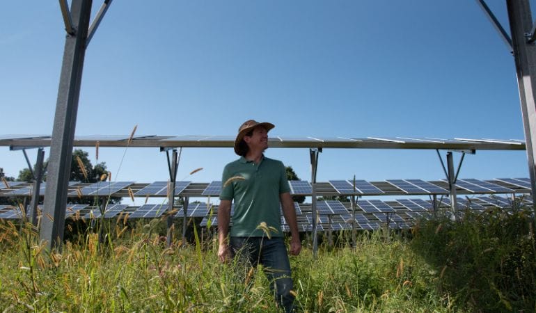
In a year or two, things will look different here. Knowlton Farm will produce not only hay, but berries, pumpkins, leafy greens, and grass-fed beef—all underneath 3.1 megawatts (MW) of “agrivoltaic” solar arrays built to allow for production of renewable energy and crops on the same land. The income from this newly installed solar project will allow Knowlton to hold on to the farm, which his family has owned since the 1800s; he’ll also be able to plant new crops, acquire a small head of cattle, and experiment with regenerative farming practices that can help improve soil health, restore ecosystems, and sequester carbon. The arrays are part of a community solar project growing here that will produce enough electricity to power about 520 homes. A smaller array powers the farm’s activities.
One such array undulates across a two-acre field behind the farmhouse. Unlike conventional ground-mounted solar arrays that hug the earth, this agrivoltaic array towers nine feet high. Knowlton planted a cover crop of winter rye grass to prepare the field for spring planting, and Monarchs and other butterflies flit among the rye and scattered wildflowers that pop up beneath the rows of gleaming panels. The panels are spaced dozens of feet apart to allow farm equipment to pass between them.
Agrivoltaic systems, also known as dual-use solar, have been successfully deployed in Japan and some European countries over the last decade. They are emerging in the United States as a potentially promising way for farmland to contribute to climate mitigation and resilience, while keeping farmers on their land at a time of fundamental disruption in agriculture. Meanwhile, in the drought-stricken West, climate-smart agricultural transition strategies are encouraging the installation of more conventional solar energy systems on farmland that must be taken out of production.
Siting renewable energy on farmland isn’t a new concept in this country. In the wind-rich Plains states, wind development has helped prop up struggling farm economies for a decade, and a 2021 study by Cornell University found that 44 percent of existing utility-scale solar in New York State has been developed on agricultural land (Katkar et al. 2021). Farmland’s wide-open spaces are particularly well-suited for renewable energy development, and it’s generally easier to connect rural solar projects to the grid because there is greater transmission capacity available, in comparison to dense urban areas. Farmers benefit from the payments for leasing a portion of their land, which can make all the difference at a time of rising farm bankruptcies.
Now, as renewable energy gains strength and world leaders commit to energy transition goals, new opportunities are emerging. Solar is booming in the United States as photovoltaic costs continue to drop. The industry grew at a clip of 42 percent annually over the past decade. As of 2020 it was valued at $25.3 billion, with more than 100 Gigawatts of solar now installed in the country. President Biden’s recent announcement of an economy-wide goal of net-zero emissions of greenhouse gases by 2050 ups the ante; Princeton University researchers estimate the net-zero goal will require the deployment of solar and wind energy on about 150 million acres, or land equivalent in size to Wyoming and Colorado (Larson et al. 2020). That could be a sizable chunk of U.S. farmland, which totaled nearly 900 million acres in 2020. At the same time, California’s Sustainable Groundwater Management Act is driving the retirement of 500,000 to 1 million acres of the Central Valley’s 5 million acres of irrigated farmland by 2040, as part of an effort to rebalance the state’s groundwater supplies.
Investing in renewable energy on farmland could be a win for climate mitigation, conservation, and agriculture—for farmers and their local economies—but only if it’s done right, observers say. Dual-use solar represents “a potentially significant opportunity for agriculture and for rural America,” says David Haight, vice president of programs at American Farmland Trust, which is a third-party certifier for the Knowlton Farm project. “But it has to be done with farming in mind, and so that it doesn’t result in displacing farming across large parts of our landscape.”
Haight says 90 percent of new solar capacity built by 2050 will be developed in rural areas. Solar on non-working farmland, meanwhile, can boost conservation goals by keeping farmers on their land. Well-managed farmland can provide a range of ecosystem services, from sequestering carbon to providing habitat for diverse native plant and animal species to buffering against floods, drought, and heat.
Whether solar complements agricultural operations or replaces them on a portion of a farm, the associated revenue “can help financially struggling farmers sustain themselves through bad weather or tough economic times,” says Jim Holway, director of the Lincoln Institute’s Babbitt Center for Land and Water Policy. Revenue from renewables, he adds, can also provide funds for socially beneficial water efficiency improvements or other soil and land conservation investments.
Dual-Use Solar in the Northeast
Between 2001 and 2016, according to the American Farmland Trust, approximately 105,500 acres of New England’s 3.97 million acres of farmland were lost to or threatened by development. Roughly 35 percent was irrevocably lost to urban development, while the remaining acreage was impacted by low-density residential development, which ultimately changes the nature of rural communities.
Climate change adds further pressure, as extreme downpours, flooding, and intermittent drought, among other impacts, make farming more challenging (see sidebar). “The future unknowns of how to maintain farm viability are getting larger, and that leads to a lot of uncertainty about farmland staying in farming,” says Emily Cole, New England deputy director at American Farmland Trust.
Agriculture is responsible for roughly one-fifth of global greenhouse gas emissions, but efforts to shift to farming practices that sequester carbon in soil could help agriculture be part of the solution; the National Academy of Sciences estimates the carbon sequestration potential of U.S. agricultural soil at 276 million tons of carbon dioxide equivalent, or 4 percent of U.S. emissions. Once farmland leaves a farmer’s hands for permanent development, however, that’s no longer possible, says Cole. “There’s no more opportunity to improve soil health practices or garner clean energy.”
Paul Knowlton knows these pressures firsthand. Grafton is ground zero for what Massachusetts Audubon calls “the Sprawl Frontier,” a belt of rapidly developing communities in central Massachusetts outside Worcester, New England’s second-largest city. Land prices are high, and aging farmers face increasing pressure to sell their land. Knowlton has been approached by developers and even works as a carpenter in residential construction to supplement his farming income. “Every time I go to work, I see a farm destroyed. I am part of the machine, and I don’t like it,” he laments.
For a time after selling its herd, the Knowlton family made ends meet with the hay operation and income from other jobs. But when the farmhouse needed major renovation, the family carved off one housing lot and sold it to a developer. That’s when Knowlton decided there had to be another way. In 2015, he installed a 2.5 MW conventional solar array that stabilized the farm economically with its lease payments. That success got Knowlton thinking that maybe he could install more solar arrays, but in a way that would allow him to plant around them. Coincidentally, the solar developer that built his first array, BlueWave, was thinking the same thing.
BlueWave was founded by John DeVillars, a former Massachusetts Secretary of Environment and regional EPA administrator who has strong connections to the conservation community. It was one of the first solar developers in the state to jump on the incentives that Massachusetts’ 2018 Solar Massachusetts Renewable Target (SMART) program provides for dual-use solar projects.
“Our motivation is as much for land protection and supporting community and agriculture, as it is clean energy,” notes DeVillars. “Agrivoltaics is a great chance to strengthen rural communities . . . and allow everyone to share in the benefits of a cleaner environment and locally produced, healthier food.”
The Knowlton Farm deal involves a slew of parties: AES, a global energy company that owns the project; the Massachusetts Department of Energy and Department of Agriculture; the University of Massachusetts, which will study the impact of the systems on the farm’s crop yields and soil conditions; American Farmland Trust; and a farm consultant, Iain Ward, who BlueWave recruited to help develop the planting plans and serve as an advisor to Knowlton. AES provides Knowlton with lease payments and a stipend to cover his farming costs, which will eventually allow him to retire from carpentry and achieve his lifelong dream of farming full-time.
Not all dual-use solar developers pay stipends and hire farming consultants. Others simply pay the farmer to lease the land. “BlueWave’s model is progressive,” says Ward. “It’s farmer-first, farmer-friendly . . . the spirit of what I believe dual-use was intended to be.”
Ward is a cranberry grower and an evangelist for regenerative agriculture who views dual-use solar as an opportunity to pay farmers to experiment with growing crops in new ways. He launched his own consulting business, Solar Agricultural Services, a few years ago. Decked in jeans and T-shirt, boots, and a brown sun hat, Ward shows a visitor Knowlton’s second, much larger dual-use array, located in a former pasture down the road from the hayfield. The panels in both arrays are bifacial, he says, meaning they allow some sunlight to penetrate their surface and reflect off the ground, which provides the crops more sunlight. The field under this 11.5-acre array will become pasture for beef cows in a year or two. Knowlton will plant mainly forage grasses, with some radishes and sugar pumpkins to support soil health. The field is now planted with a cover crop of winter rye grass.
Knowlton is especially excited about the cows. “We haven’t had animals for so long,” he said wistfully, recalling how he used to milk the cows with his father and grandfather every weekend and every day after work. “I’m looking forward to getting back to that.”
Ward hopes the results from Knowlton Farm will help inform a national conversation that could spur greater adoption of dual-use solar. Research to date has largely been conducted in experimental settings. A University of Arizona study on cherry tomatoes and two types of peppers found that the crops did better because they were spared direct sun. Jalapeño peppers lost less water via transpiration, suggesting that growing crops under PV panels can save water in a hot, dry climate (Barron-Gafford et al. 2019).
Unpublished research from the University of Massachusetts similarly found that the solar panels helped reduce heat stress and contribute to higher yields for crops like broccoli, Swiss chard, kale, and peppers, though shade decreased yield in some crops (Sandler, Mupambi, and Jeranyami 2019). An analysis by researchers in Japan found certain types of agrivoltaic systems worked even with shade-intolerant crops like corn (Sekiyama and Nagashima 2019).
Dual-use solar is likely best suited for smaller projects in regions where competition for land is stiff, because the economics are difficult without incentives, and a tremendous amount of oversight and technical assistance is required to ensure that farm management plans are sound. Construction costs for dual-use solar are roughly 40 percent higher than for conventional solar, says Drew Pierson, head of sustainability at BlueWave. Raised canopies increase both materials and labor costs. Insurance costs are also higher because of ongoing activity underneath the panels.
Massachusetts leads the nation in dual-use solar because of its SMART program, which was designed to add 3,200 MW of solar to the grid. Under SMART, dual-use projects are eligible for a base compensation rate of $0.14–$0.26 per kWh of electricity produced, depending on the project size and local utility, and they receive an additional $0.06 per kWh federal incentive. To date, 11 projects, totaling 23 MW, have met the state’s rigorous eligibility requirements. (Even with the incentives, says De Villars, “the economics are very, very challenging, to say the least.”)
New Jersey passed a similar incentive to Massachusetts last year. New York scores solar projects better if they have agrivoltaic features, but it’s unclear whether that will help incentivize projects or simply hasten their permitting, says Pierson. Agrivoltaics are also being developed for pollinator fields and rangeland in the Midwest and West. Meanwhile, researchers in California are studying whether solar installations could keep fallow farmland from disappearing altogether.
Agriculture and Climate Change
Agriculture and associated land use changes such as deforestation produced an estimated 17 percent of global greenhouse gas emissions in 2018, according to the Food and Agriculture Organization (FAO) of the United Nations. Factor in related activities such as packaging and processing, says the FAO, and the food system accounts for 34 percent of all emissions—a figure expected to rise as global population soars. Even as it contributes to climate change, agriculture is vulnerable to climate impacts: hotter temperatures, droughts, pests, and flooding are affecting crop yields, livestock conditions, and other critical elements of a functioning food supply. Regenerative practices that restore ecosystem health and sequester carbon, such as no-till methods and use of cover crops, are increasingly touted as a way for farmers to build resilience and be part of the climate solution.
Solar on Farmland in the West
In the West, water—or lack of it—is emerging as a key driver for renewable energy siting on farmland. Severe drought linked to climate change is shrinking water supplies just as population growth is increasing demand. With the federal declaration of drought in the Colorado River Basin in 2021, farmers in central Arizona face steep cuts in their allotment of river water. California and Colorado are similarly struggling to balance agricultural water use, rising urban water demands, and shrinking resources.
“There’s always been this idea that the best soil is what determines the best agricultural land. We’re in a new paradigm here, and the best soil without water is dirt,” notes Lorelei Oviatt, director of planning for Kern County, California.
In an effort to gain control of dwindling supplies, California passed the Sustainable Groundwater Management Act (SGMA) in 2014. One of the act’s key strategies is fallowing farmland. With farmland transitions on the table in California and other places in the drought-stricken West, the Babbitt Center for Land and Water Policy is researching sustainable futures for agriculture, and how to get from here to there, says Holway, the center’s director.
Holway’s team is exploring how to facilitate voluntary transitions of agricultural land in a way that uses land markets, maintains agricultural economies, and keeps the most productive agriculture land in cultivation. The center is also investigating how to maximize ecosystem benefits and possibly sequester carbon on retired farmland. As part of this work, the Babbitt Center provided funding to the Public Policy Institute of California (PPIC) to investigate the potential for solar development in the San Joaquin Valley.

Credit: Kelly M. Grow/Department of Water Resources.
That region, which occupies the southern part of the state’s famously productive Central Valley, has the largest groundwater deficit in California and faces some of the worst impacts from overdraft, including land subsidence and drying wells, according to Ellen Hanak, vice president and director of the PPIC Water Policy Center. PPIC estimates that 10 to 20 percent of the valley’s farmland—500,000 to 1 million acres—will need to be retired to comply with the SGMA.
“If we don’t plan how that transition happens, it’s going to have a billion-dollar economic impact,” says Holway. Home foreclosures, bankruptcies, and supply chain disruptions are among the cascading impacts that could ensue from haphazard land fallowing. PPIC is studying how solar development can facilitate the necessary agricultural retirement in a way that sustains income for farmers. The research is part of a larger study on climate-smart agricultural transitions that is looking at the benefits and costs of different land management options. PPIC is also exploring issues such as the air quality risks that arise from the dust, pests, and weeds that build up from different types of land fallowing, and the potential for winter rain-fed cropping.
“We’re working with folks to look at some alternatives that could bring in revenues and avoid negative externalities, but also potentially generate some benefits, like soil carbon [storage], soil moisture retention, and habitat [protection]. Solar comes into this as one of the options that looks especially promising,” notes Hanak.
The Nature Conservancy (TNC) is also zeroing in on the San Joaquin Valley for renewable energy development. Its 2019 “Power of Place” report identified the San Joaquin as a promising location for the state to meet its renewable energy goals because it is more ecologically degraded than California’s inland deserts, where bighorn sheep, desert tortoises, and golden eagles still roam (Wu et al. 2019). California set a goal of reducing greenhouse gas emissions by 80 percent below 1990 levels by 2050. Additionally, it passed a law in 2018 requiring renewable energy resources to supply 100 percent of electricity by 2045.
“TNC is obviously in favor of renewable energy development, but we’re very interested in rolling it out in ways that don’t harm existing habitat,” emphasizes Abigail Hart, project director in TNC’s California Water Program. “If you’re going to site renewable energy facilities on conservation land or agricultural land, then you need to make sure you’re doing it in places that aren’t critically important for some other reason like habitat,” confirms Jim Levitt, director of the International Land Conservation Network at the Lincoln Institute. “It’s important to be strategic.”
Utility-scale solar is already underway in the San Joaquin Valley. Westlands Solar Park, one of the largest solar developments in the world, is under construction on 20,000 acres of former farmland that was contaminated with selenium in Fresno and King counties. The developer, CIM Group, plans to install at least 2,700 megawatts by the end of the decade, providing clean energy to more than 750,000 households.
A smaller, 20 MW project was installed by E.ON Solar at Maricopa Orchards, a Kern County grower of almonds, oranges, and other crops. That project is part of a 6,000-acre habitat conservation plan devised by Maricopa Orchards and local officials; the plan allows solar development on 4,000 acres of farmland, but sets aside 2,000 acres as habitat for San Joaquin kit foxes, blunt-nosed leopard lizards, burrowing owls, and other at-risk species. “In some cases, land that has been out of production even for a couple of years can function as habitat for at-risk species,” explained Hart. The 2,000-acre set aside will allow for wildlife corridors on the property. The 20 MW array, which occupies 160 acres and is now owned by Dominion Energy of Virginia, is the first of multiple expected projects on the rest of the Maricopa parcel. Hart said that TNC looks to the deal “as a compelling example of how solar development could be done on impaired lands in a way that provides renewable energy and valuable habitat.”
While wind and solar are high-value options for landowners, communities tend to question whether they provide “the same juice to the local economy” as housing or commercial development, says Hanak. Some communities, like San Bernardino County, have banned utility solar altogether.
California’s solar tax exclusion, a statewide incentive passed in the early 2000s that prevents the installation of qualifying solar energy systems from affecting the assessment of a property, is one reason why communities fret the economics. It made sense for rooftop installations and smaller-scale projects, but does not work for today’s large-scale solar projects, observes Oviatt. Hanak agrees, noting that PPIC is investigating “the different ways to pay for solar so that it’s not coming at the expense of the coffers of a poor rural county.”
There are other practicalities to consider. In Kern County, one of the largest in the valley, transmission capacity is a limiting factor, says Oviatt. Kern County has already developed 50,000 acres of solar, mostly on marginal lands. “We are now catching up with all of the solar that we have,” she says. Without additional transmission lines, farmers will not be able to sell their land to renewable energy developers. Kern County is therefore looking at other possible uses for retired agricultural land, including carbon capture and sequestration technologies.
Path Forward
Both dual-use and conventional solar development on farmland hold promise for helping individual states and the United States as a whole meet aggressive renewable energy goals. Solar on farmland cuts greenhouse gas emissions from the energy sector and, when done right, can help conserve land and protect biodiversity and water resources. Jeremy McDiarmid, vice president of the New England Clean Energy Council, points out that solar can be an impermanent development strategy, unlike housing or commercial real estate. What communities need to do, he says, is “find the balance between preserving open space and developing clean energy resources that are going to . . . create local jobs and help meet climate targets.”
American Farmland Trust is crafting a set of principles to guide siting of renewable energy on farmland in a way that protects farmers and, where farmland is still active, improves viability and productivity. Those principles also recommend making full use of locations like brownfields, abandoned mines, and urban rooftops. “There are plenty of options out there with limited land impacts,” says Haight. “However, we’re also aware that we will not be able to site everything on brownfields and within the built environment.”
Cole sees an opportunity for engaging in conversations state by state to identify where the best farmland is, what agricultural communities’ needs are, and what each state’s solar and land protection goals are to develop state-specific guidelines and programs.
Such conversations are just beginning in California, Massachusetts, and New York. In California, the Strategic Growth Council, a state agency, is funding PPIC’s climate-smart agricultural transition and solar research to help plan the San Joaquin Valley’s future. In Massachusetts, the Department of Energy Resources is studying the solar potential for the Commonwealth and will likely layer in both technical feasibility and competing land uses for biodiversity and open space protections, according to McDiarmid. And in New York State, Cornell Professor Max Zhang said his recent study on strategic land use analysis for solar energy development precipitated a meeting with state senators (Katkar et al. 2021).
Meanwhile, Levitt thinks the agricultural sector could see additional disruptions in the next few decades. Severe water shortages in arid and semi-arid landscapes are one potential driver of change. The traditional dairy and meat industries could also be increasingly displaced by alternative products such as nut milks and synthetic meats. Such disruption could free up a substantial amount of land for regenerative farming, renewables development, carbon sequestration, aquifer recharging, and wildlife protection, particularly in the swath of the middle of the country that’s now used for pasturing livestock and growing the crops that feed them.
“Just as change in the pattern of land use in California is emerging, these trends could alter longstanding patterns of land use across North America,” says Levitt. While powerful industrial agriculture associations will do what it takes to minimize disruption—as will states where agriculture is integral to identity, culture, and economics—Levitt says the potential for dramatic change is there, and the forces driving change may well intensify over time.
As dual-use systems get up and running on Knowlton Farm and elsewhere, questions remain about how scalable dual-use solar will be across different geographies and farm systems. Scaling up conventional solar on retired farmland is more straightforward, but will likely be limited by such factors as local transmission capacity or economic incentives. Regardless, solar energy development on both working and non-working farmland is an important tool for confronting the climate crisis. The faster the solar industry can perfect systems that keep farmers on their land and agricultural production intact—or optimized for water sustainability—the better humanity’s chances for preserving a livable planet.
Meg Wilcox is an environmental journalist covering climate change, environmental health, and sustainable food systems. Her work has appeared in The Boston Globe, Scientific American, Next City, Smithsonian, Salon, Eater, Civil Eats, and other outlets.
Lead image: Solar consultant Iain Ward stands among the agrivoltaic panels at Knowlton Farm in Grafton, Massachusetts. Credit: Meg Wilcox.
References
Barron-Gafford, Greg A., Mitchell A. Pavao-Zuckerman, Rebecca L. Minor, Leland F. Sutter, Isaiah Barnett-Moreno, Daniel T. Blackett, Moses Thompson, Kirk Dimond, Andrea K. Gerlak, Gary P. Nabhan, and Jordan E. Macknick. 2019. “Agrivoltaics Provide Mutual Benefits Across the Food-Energy-Water Nexus in Drylands.” Nature Sustainability 2: 848–855. https://www.nature.com/articles/s41893-019-0364-5.
Katkar, Venktesh V., Jeffrey A. Sward, Alex Worsley, and K. Max Zhang. 2021. “Strategic Land Use Analysis for Solar Energy Development in New York State.” Renewable Energy 173: 861–875. https://www.sciencedirect.com/science/article/abs/pii/S0960148121004900.
Larson, Eric, Chris Greig, Jesse Jenkins, Erin Mayfield, Andrew Pascale, Chuan Zhang, Joshua Drossman, Robert Williams, Steve Pacala, and Robert Socolow. 2020. “Net-Zero America: Potential Pathways, Infrastructure, and Impacts.” Princeton, N.J.: Princeton University. December 15. https://netzeroamerica.princeton.edu/img/Princeton_NZA_Interim_Report_15_Dec_2020_FINAL.pdf.
Sandler, Hilary, Giverson Mupambi, and Peter Jeranyama. 2019. “Expectations for Cranberry Growth and Productivity Under Solar (Photovoltaic) Panels.” East Wareham, MA: UMass Cranberry Station. May. https://ag.umass.edu/sites/ag.umass.edu/files/pdf-doc-ppt/shading_and_solar_panels_may_2019.pdf.
Sekiyama, Takashi, and Akira Nagashima. 2019. “Solar Sharing for Both Food and Clean Energy Production: Performance of Agrivoltaic Systems for Corn, a Typical Shade-Intolerant Crop.” Environments 6(6): 65. https://doi.org/10.3390/environments6060065.
Wu, Grace C., Emily Leslie, Douglas Allen, Oluwafemi Sawyerr, D. Richard Cameron, Erica Brand, Brian Cohen, Marcela Ochoa, and Arne Olson. 2019. “Power of Place: Land Conservation and Clean Energy Pathways for California.” Washington, DC: The Nature Conservancy. August. https://www.scienceforconservation.org/products/power-of-place.

After a year of intensifying drought, fires, and floods, leaders of the conservation movement are tapping into widespread concern about climate change by emphasizing that forests, grasslands, parks, and peat bogs play a critical role in both soaking up carbon and building resilience.
Last fall, scientists at The Nature Conservancy (TNC) released a list of forests from Washington to Georgia that, if properly protected, could help remove millions of metric tons of carbon dioxide from the air each year. Around the same time, a coalition of conservation groups and sustainable business organizations called US Nature4Climate launched a campaign under the banner, “Conservation IS Climate Action.” A few days after that, Cities4Forests, a group of 73 cities committed to forest conservation and restoration, issued a call to action urging urban leaders to embrace nature-based climate solutions.
With the existential threat of climate change vaulting to the top of the hierarchy of global problems, conservationists are increasingly emphasizing the critical role of land, from rural forests to working landscapes to urban street trees, in confronting that challenge. Significant ongoing work to protect land and preserve biodiversity falls under the rubric of natural climate solutions, defined by TNC as “conservation, restoration, and improved land management actions that increase carbon storage or avoid greenhouse gas emissions in landscapes and wetlands across the globe.”
“There’s nothing better for keeping carbon in the ground and extracting more carbon out of the air than simply protecting forests,” said Mark Anderson, director of TNC’s Center for Resilient Conservation Science, which recently added carbon storage to the searchable criteria in its popular online Resilient Land Mapping Tool. “Our most important partner is the living land.”
Land conservation can have multiple benefits of critical value in this era, said Jim Levitt, director of the International Land Conservation Network (ILCN). In addition to carbon sequestration, “conserved coastlines can buffer us from sea-level rise. Vibrant tree growth in cities can mitigate heat-island effects. Farms with vegetative buffers can substantially reduce water pollution. Protected highlands can provide clean water to dense urban centers,” said Levitt, who coauthored a forthcoming Policy Focus Report about civic conservation groups providing climate solutions. “The list goes on.”
Conservation got special attention at the COP26 climate summit in Glasgow in November, when leaders of more than 140 nations pledged to end deforestation and land degradation by 2030, expanding a commitment made by 39 nations in 2014. The Glasgow pledge followed a commitment by 50 countries to protect 30 percent of the world’s lands and oceans by 2030. The Biden administration’s commitment to the 30×30 campaign, America the Beautiful, will strive to protect over 720 million acres during the coming decade, in part to address “the need to fight climate change with the natural solutions that our forests, agricultural lands, and the ocean provide.”
Land is not a panacea for climate change, which is a crisis that will need to be actively addressed by many sectors. But the climate advantages of preserving land are “irrefutable,” says Anderson, who is the Lincoln Institute’s current Kingsbury Browne fellow. It’s a connection that also has emotional resonance: a recent newsletter from the Land Trust Alliance (LTA), which represents more than 1,000 land trusts and affiliates across the country, suggested land was “the answer to climate despair.”
For Fernando Lloveras San Miguel, executive director of the Conservation Trust of Puerto Rico and a former Kingsbury Browne fellow, this moment for land conservation represents a kind of coming full circle. “Climate change is the result of a lack of land conservation,” he said, pinning the global crisis on rapacious consumption and unsustainable land development practices that have ignored the functionality of ecosystems. His message: “Don’t destroy the basic systems that support life.”
Those systems are particularly well-suited to help in the fight against climate change. Recent studies suggest that forest, grassland, and peatland ecosystems may be even more exceptional at soaking up and storing carbon than previously understood—both aboveground and underground. They can create microclimates that fend off warming temperature trends and even adapt to serve the needs of animals, modifying habitats as wildlife species, by necessity, revise their own specifications for survival to make it through all the climate upheaval. In a warming world where terrifying feedback loops are becoming commonplace, the healthy ecosystem—carefully protected and sustainably managed—promotes a virtuous cycle of biodiversity, a kind of continually improving and more efficient functionality.
The obvious benefits of protecting land stand in sharp contrast to what has been happening, literally, on the ground. Deforestation continues apace as land is cleared for development or agriculture, or ravaged by wildfire, drought, and mudslide-inducing floods. That destruction leads to negative outcomes, simultaneously eliminating vast carbon sinks and spewing new emissions into the atmosphere. Fires release embodied carbon in vegetation and soil, and then emissions intensive development and agriculture—including methane from cows on any land cleared for grazing—is ushered in. So it was that in 2021, the Amazon rainforest started emitting more CO2 than it absorbs.
Similar patterns are emerging around the globe, including in the northeastern United States. Clark University researchers found that the six New England states and New York are collectively releasing an estimated 4.9 million metric tons of carbon dioxide equivalent into the atmosphere each year through forest loss. The loss of carbon storage power means the region is missing out on 1.2 million metric tons of CO2 equivalent (CO2e) in carbon sequestration each year.
“Deforestation is a direct source of carbon emissions, releasing the carbon stored in trees and roots into the atmosphere as carbon dioxide. It also negates one of the best tools we have for drawing carbon dioxide back out of the atmosphere,” wrote the Clark research team. “Thus, slowing the pace of forest loss is an important instrument in the fight against climate change.”
The climate mitigating power of land is so great, economists and others argue that the value of natural ecosystems should be integrated into the global economy—to put a price tag on the climate benefits of land. This perspective was spelled out most recently in the Independent Review on the Economics of Biodiversity led by Sir Partha Dasgupta, professor of economics at Cambridge and fellow of St John’s College.
In the report, which some characterized as the land-oriented equivalent of Sir Nicholas Stern’s watershed 2006 report about the high costs of inaction on climate, Dasgupta identifies nature as “our most precious asset,” one that humanity has badly mismanaged. “My overarching aim is the reconstruction of economics to include nature as an ingredient,” he said.
Land’s role in the climate crisis does have its limits, some say. “There aren’t enough trees in the world to offset society’s carbon emissions, and there never will be,” writes Bonnie Waring, an ecologist at Imperial College London. “If we absolutely maximized the amount of vegetation all land on Earth could hold, we’d sequester enough carbon to offset about ten years of greenhouse gas emissions at current rates. After that, there could be no further increase in carbon capture.”
Planting and protecting trees is valuable, climate activists say, but shouldn’t distract from other major steps necessary to meaningful climate progress: reducing emissions in the transportation, building, and energy sectors; and decarbonizing the economy by ending government fossil-fuel subsidies and support from private financial institutions.
As the climate crisis gains speed, conservationists must also contend with emerging issues. Investors and real estate speculators are making huge acquisitions of land on higher ground that will be more productive given warmer temperatures and new rainfall patterns. And a debate has erupted over land-based carbon offsets, which allow polluters to counter their emissions by paying for greenhouse gases to be removed from the atmosphere somewhere else. Critics say the credits let polluters off the hook, allowing them to continue to emit greenhouse gases while they support sequestration functions that would be happening in protected areas either way. It should not surprise that land’s role in climate change would be as complex as the problem itself.
Land Conservation and the Lincoln Institute
Conservation became part of the Lincoln Institute’s portfolio through research on the taxation and assessment of land. In 1976, federal law began allowing tax deductions for gifts of conservation easements—donations of development rights on property that remained in private ownership. But the legislation that recognized this new instrument did not address the property tax consequences of easements, and assessors were unsure about how to value property that had a new legal status but unchanged physical characteristics. The Lincoln Institute, responding to requests for help from environmental groups and assessors, developed courses on this interplay of easements and the property tax.
During the 1980s, the organization’s interest in land stewardship grew, with staff and study groups dedicated to the topic. In 1981, a Boston attorney on sabbatical to study voluntary conservation, Kingsbury Browne, organized a national convening at the Lincoln Institute’s headquarters. The participants, affiliated with some 40 land trusts and related groups from Maine to California, resolved to form a national Land Trust Exchange, which became the Land Trust Alliance (LTA). Now a significant catalyst for conservation, LTA has 1,000-plus member organizations and affiliates that have protected 61 million acres nationwide. Browne’s legacy lives on eponymously in an annual award from LTA and a Lincoln Institute fellowship.
Today, the Lincoln Institute has identified “sustainably managed land and water resources” as one of its six primary goals. The International Land Conservation Network, launched in 2014, builds capacity for conservation around the world; the Babbitt Center for Land and Water Policy, launched in 2017, promotes the integration of land and water planning, primarily in the U.S. West.
“You can’t mitigate climate change without the land sector,” says Andrew Bowman, president of the LTA. Bowman said most of the group’s members are considering climate change prominently in their stewardship practices, land management, and restoration activities. But it’s not the only thing shaping today’s conservation actions: “We have interconnected crises of climate, biodiversity, and equity.”
Add public health to that mix. The pandemic underscored the need to better understand biodiversity, habitat loss, and the interaction of humans and wildlife. “Restoring and protecting nature,” observed a National Science Foundation research announcement, “is essential to preventing future pandemics.”
It could also be essential to surviving them. “Land conservation and restoration is critical to addressing the climate crisis, but is also central to the health of our communities—along that whole spectrum from urban parks to remote wildlands,” said Jamie Williams, president of The Wilderness Society and the 2009 Kingsbury Browne fellow. “The pandemic has shown just how central time in nature is to our resiliency, emotional, physical, and mental health. Studies bear that out, so a big focus of ours has been on creating greater park equity in urban areas and securing equitable access to the outdoors.”
Equity is a critical part of the current conservation-climate conversation. By drawing attention to their role in the coalescing worldwide campaign to address climate change, conservation leaders can create a bigger tent, diversifying their ranks and reaching people who might not otherwise make the link between climate and land. An increasingly intentional focus on climate equity, borne out in campaigns for equitable access to urban parks, partnerships with sovereign tribal nations, and the like, has the potential to further expand the movement’s reach and impact.
Climate and Conservation Facts
Total tons of carbon dioxide emitted by humans each year: 11 billion
Amount from burning fossil fuels: 9.5 billion
Amount from deforestation: 1.5 billion
Percent of human-produced carbon dioxide absorbed by land and water: 50
Percent by which human-produced carbon dioxide has increased since 1750: 50
Metric tons of carbon dioxide a typical 1,000-acre forest in the eastern United States can soak up each year: 180
Acres of land protected by civic conservation in the United States: 61 million
Percent of oceans legally protected, globally: 7
Percent of land legally protected, globally: 15
Percent of land and oceans the world is working to protect by 2030: 30
Sources: Climate.gov, The Nature Conservancy, Land Trust Alliance, International Union for Conservation of Nature.
Indigenous communities, in particular, are at the ready with creative, nature-based solutions. Some 50 tribes in the United States have developed far-reaching, nature-based climate action plans on indigenous lands across the country, including activities from coastal restoration to prescribed burns. Tribes are “using traditional knowledge, but taking advantage of the science and the data,” said Nikki Cooley, co-manager of the Tribes and Climate Change Program for the Institute for Tribal Environmental Professionals in Flagstaff, Arizona. The approach reflects the cultural perspective of indigenous nations, she said, “that they have a responsibility to the Earth, a relationship with the Earth . . . connecting people to the land.”
In Gowanus, Brooklyn, urban landscape architects find themselves in common cause with traditional conservation organizations as they work together to protect biodiversity and build climate resilience in densely developed urban corridors. “Networks of green infrastructure in cities create a refuge for wildlife,” said Susannah Drake, adjunct professor at The Cooper Union for the Advancement of Science and Art. “Dark skies, greenbelts, and adapted right of way corridors link [rural areas] with urban centers.”
The linkages, she said, “revive the large landscape productivity of regions . . . . If we can’t take all the land back [for conservation], we know enough about landscape ecology to make the urban-suburban-rural transect embody greater biodiversity.”
On an even broader scale, the Biden administration’s America the Beautiful program “presents an enormous opportunity to bring the climate and conservation agendas into better alignment, if not explicitly link them,” said Sacha Spector, program director for the Environment at the Doris Duke Charitable Foundation, who noted the existence of a longstanding division between conservation and climate funders, even within the same foundations. “That means engaging all sorts of potential stakeholders and funders in this more holistic understanding of land conservation and stewardship, from urban reforestation and greenspace advocates to the big climate funders, to health and resilience interests. For both biodiversity and climate, this is an all-hands-on-deck moment.”
In 2019, as part of an effort to bolster support for the 30×30 campaign, the Center for American Progress issued a report on the state of America’s natural areas. The report suggested that the question of how much nature to keep—in an effort to “curb wildlife extinctions, fight climate change, reduce toxic pollution, and safeguard healthy natural systems upon which future generations will depend”—should be the subject of an urgent national conversation.
“There can be no single or simple answer to a question that is simultaneously moral, economic, religious, historical, cultural, scientific, and, for many people, deeply personal,” says the report. “A discussion of how much nature to protect—and how, where, and for whom—must honor and account for the perspectives of all people, including communities that are disproportionately affected by the degradation of natural systems; communities that do not have equal access to the outdoors; tribal nations whose sovereign rights over lands, waters, and wildlife should be finally and fully upheld; communities of color; and others.” It’s been only two years since the report was issued, but that discussion has taken on even greater urgency in the face of the global pandemic, widespread calls for addressing racial injustice, and the increasingly visible effects of climate change.
Ultimately, climate and biodiversity are “braided together,” says Levitt. Addressing climate change in a meaningful way requires understanding those connections—and understanding our own role in the nature of things.
“Forests are . . . the unknowably complex green webs that bind together the fates of millions of known species, with millions more still waiting to be discovered,” writes Waring, the ecology professor at Imperial College. “To survive and thrive in a future of dramatic global change, we will have to respect that tangled web and our place in it.”
Anthony Flint is a senior fellow at the Lincoln Institute, host of the Land Matters podcast, and a contributing editor to Land Lines.
Image: Indonesia peatland. Credit: Rifky/CIFOR via Flickr.

These days, we tend to expect technology to deliver ever more sophisticated data, in ever greater quantities. That’s just as true for users of everyday tech tools as it is for high-level decision makers relying on the most cutting-edge and complex tools to grapple with knotty challenges like conservation and climate change. But sometimes the more important priority is to make the best use of the data and technology that already exist.
That spirit has helped guide some of the early work of the Center for Geospatial Solutions (CGS), launched by the Lincoln Institute in 2020. A nonprofit, mission-driven entity focused on marshalling data and mapping tools to support land use decisions, CGS works with a range of global partners large and small, both on deploying new technology and on helping organizations navigate the tools and information they already have.
Think of it as a hub of data, expertise, and service: “There’s a ton of data,” as well as platforms and tools, says Anne Scott, executive director of CGS. “If you’re there on the ground, trying to do something for your community, it can be overwhelming. We are here to help with that.”
One of the more ambitious early enterprises for CGS has been a collaboration with the Nature Conservancy of Canada (NCC), a private nonprofit focused on conservation. NCC is a large, fast-growing organization with a long track record. Today it protects land equivalent to the size of Florida, spread across multiple provinces. Its interest in sorting out a multiyear strategy to make the most of the mapping and other technologies it was already using led it to seek out the help of CGS. The resulting work in progress is an instructive example of how CGS can play a vital role in helping inform and shape both immediate-term and long-term strategy.
Clearly NCC was already deploying plenty of advanced geospatial tools, but, as its chief conservation officer Marie-Michèle Rousseau-Clair notes, NCC is a land trust, not a tech organization: “Our business is to do conservation.” With that guiding principle in mind, CGS conducted a deep organizational-tech dive, collecting information from around 125 NCC staffers across its Canada-wide outposts.
“We were looking for opportunities, gaps, and pinch points,” says Jeff Allenby, director of geospatial technology for CGS. Allenby noted that this initial analysis was intended to seek ways for NCC to save time and streamline work by, for example, making consistent the way field data are collected and shared across regional offices. Or if, say, certain staff members are emailing several colleagues a day to collect particular nuggets of information, maybe there is a way that process can be automated. CGS has now made a set of recommendations to implement over 18 months, designed to improve NCC’s tech and data processes.
The beginning of the relationship between NCC and CGS happened to intersect with the onset of the pandemic, when regulations restricted NCC field workers from gathering data in person. “There was an extra sense of urgency to leverage technology,” Rousseau-Clair says, and to “achieve the same kind of work with new methods.” CGS helped with creative new thinking and connections with private firms that collect satellite data that might function as a stand-in for field data collection in the short term, and perhaps a useful supplement in the longer term.
As a result of that input, NCC has set up a tech committee to provide considered oversight to the organization’s tech efforts—to make sure everyone understands how Initiative A affects Department B. That may not be the sexiest tech story, Rousseau-Clair says with a laugh, but it lays an important foundation that actually encourages innovation in the long run. “The desire for individuals to innovate is sometimes faster than the organization can change,” she says, but the CGS roadmap aims to accommodate that reality.
CGS also helps partners work directly with cutting-edge technologies for building better and more data-rich maps. It is helping one client experiment with the use of drones to supplement traditional on-the-ground fieldwork to build more comprehensive maps of invasive species (for instance, tracking kudzu’s spread as it chokes out other plants). This data can be combined with surface and elevation information—including information gathered via satellite, as well as by drones and by people on the ground—into dynamic map products.
That said, Allenby notes that while the CGS mission certainly entails keeping tabs on the cutting edge, a key goal always involves sorting out which tech tools are really helpful, and which are just flashy. That’s true whether an organization is large or small. “Just because a tool is there doesn’t mean that you should use it,” he says.
The same spirit animates the newest addition to CGS, the Internet of Water project. Spearheaded by Peter Colohan, the initiative grew out of research suggesting the need for comprehensive and widely accessible water data, analogous to the kind of mapped data associated with land use. “Let’s say you’re a decision maker in a city, like an urban planner,” Colohan says, “and you want to understand the conditions of a local reservoir and a local river over time—supply conditions, quality conditions, as they relate to runoff or particular pollutants.” In Washington, DC, as an example, you’d have to pore over something like 45 data sets to answer your questions. Thus you end up hiring a consultant to gather and organize the data, and if you want to revisit it in a year, you’ll have to do that again. “All of this data should be more readily discoverable,” Colohan concludes. “The future of water management and the future of land management are intimately connected.”
What the Internet of Water initiative recognizes is that there is plenty of water data out there, it’s just not easily accessed, falling under a mix of federal, city, county, state, and private jurisdictions. The idea is to build what amounts to a data network where anyone can “publish” water data with a common set of protocols, making that information available to all. That makes things easier for the hypothetical big-city planner who can hire a consultant, because the consultant can go straight to interpreting and strategizing around the data tranches rather than gathering information, and it also opens up that data to smaller entities that never would have considered trying to access it in the past.
For the last few years, the Internet of Water project has been incubated at Duke University. The move to CGS coincides with what Colohan calls its growth phase, which entails expanding over the next five years but also, crucially, doing so in a way that’s sustainable over time. “The internet is littered with unused tools that have no sustainability model,” he says.
As with much of the early work CGS has done with NCC and other partners, taking this longer view is precisely the key. In a way, CGS is like a consultant, keeping an eye on the latest developments across the field. “Being in the flow seat,” Allenby says. “Trying to position ourselves to know what people are doing, and how it can be applied elsewhere—and making those connections, putting those people together who should be talking to each other.”
At the same time, since CGS is not a traditional consultancy but rather part of a larger organization that is focused on truly moving the needle on land use, climate change, and related challenges, it can take a wider view. “What we’re trying to do,” Allenby says, “is really solve systemic challenges.”
Rob Walker is a journalist covering design, technology, and other subjects. He is the author of The Art of Noticing. His newsletter is at robwalker.substack.com.
Image: This aerial footage from West Virginia was taken by the Center for Geospatial Solutions as part of its work with a large-scale ecosystem restoration partner. Drone footage can complement on-the-ground fieldwork to create more dynamic maps. Credit: CGS.
Having the vision’s no solution, everything depends on execution.
—Stephen Sondheim, 1930–2021
As the world grapples with the ever-worsening consequences of the climate crisis and the terrifying prospects of mass extinction, global political leaders have responded with impressive ambition. At the 26th Conference of the Parties on Climate Change in Glasgow in late 2021, some 153 countries updated their emissions-reduction commitments to help prevent global average temperatures from rising more than 2 degrees Celsius by 2030 and improve the chances of reaching global net-zero emissions by 2050. At the same gathering, 140 countries pledged to end deforestation by 2030.
Meanwhile, at the 15th Conference of the Parties on Biodiversity (COP15), held in Kunming, 70 countries agreed to conserve 30 percent of their lands and oceans by 2030 (30×30), as part of an effort to preserve global ecosystems and prevent biodiversity losses. Many other countries are expected to sign on to the commitment this spring, when COP15 concludes. (COP15 was structured as a two-part event due to the pandemic, illustrating the complexities of reaching any kind of global agreement in the current moment.)
If achieved, 30×30 will contribute greatly to efforts to mitigate the climate crisis, primarily through carbon sequestration. Unfortunately, 2030 isn’t very far off. We’ll need more than good intentions to make progress on this ambitious goal, and land policy will play a central role in the pivot from ambition to implementation.
The Lincoln Institute and its Center for Geospatial Solutions (CGS) have developed a geospatially driven framework for accelerating progress toward the 30×30 goal. Our approach emphasizes the need to think differently about the scope of the problem and its solutions. More specifically, we think stakeholders working on 30×30 need to identify surmountable goals, introduce common accounting of conserved land, integrate environmental and social outcomes, include public and private land in conservation strategies, and build momentum through demonstrated success.

First, we need to set a baseline that accurately assesses the current state of land conservation both nationally and globally. This is more complicated than it might seem. For example, in the United States, where land records are fairly reliable, the USGS Protected Area Database tells us that 13 percent of the country is considered “conserved” explicitly for biodiversity protection. By that metric, we’d need to more than double the amount of conservation we have achieved to date to reach 30×30. If we look only at the continental United States, conserved land drops to about 8 percent, meaning we would need to almost quadruple the amount of land we conserve in the next eight years, an almost insurmountable task.
But changing how land is managed can help meet conservation goals without the need to newly protect an additional 22 percent of the nation’s land (440 million acres). For example, public and tribal ownership accounts for just over 25 percent (500 million acres) of land in the United States. That land is not considered conserved because resource extraction is allowed or there is no explicit mandate to protect biodiversity. In addition, urban and suburban parks, greenways, trails, and other municipal lands that are used for recreation are often not counted as conserved lands. Protected lands in the urban/suburban landscape play a big role in improving people’s health, addressing environmental injustice, and creating corridors and habitat for other species. Changing how land is managed, from prohibiting mining and oil exploration to explicitly protecting biodiversity, can help us gain conserved land to count toward 30×30 without requiring us to start from scratch.
Private land protected by conservation easements will also play a big role in meeting our national land protection goals. Currently the National Conservation Easement Database, the accounting system for privately conserved land, is outdated. We need better incentives for land trusts and private landowners to contribute data on their properties that will build a more comprehensive and accurate national picture of private land conservation. This will also contribute to better management and restoration outcomes.
With a combination of newly conserved land and better management of public lands to meet conservation goals, 33 percent of the continental United States could be conserved very quickly. But without a way to identify the lands that are most critical to support our conservation priorities and a commitment to conserve and count them, progress will be slow.
At the Lincoln Institute, we think a balanced prioritization strategy is needed that looks at a variety of conservation goals—including biodiversity protection, resilient and connected landscapes, and carbon sequestration—and that considers other overriding objectives, such as protecting highly productive farmland or improving access to nature for underserved communities.
We propose a more integrated view and comprehensive approach that looks at the whole country, considers multiple conservation priorities, ensures equitable access to land, and attracts effective conservation financing. Current efforts to map priorities do not account for the social component of conserving, improving, and restoring lands. Decisions about conservation should be based not only on biodiversity and environmental data but also on data about people and their needs, relationships, and interactions with land. By considering such data, we can protect land for multiple benefits to both people and nature. To illustrate the opportunities before us, CGS created an analysis that can guide collective efforts to protect critical landscapes. True to the collaborative spirit that guides the work of CGS, these maps draw upon and synthesize the collective wisdom of leading scientists and organizations focused on this effort, including NatureServe, The Nature Conservancy, and the World Conservation Monitoring Centre.
By assembling complete and accurate data on public and private lands that are or should be protected, and making this data open and freely accessible to all communities, we can achieve conservation that is inclusive and equitable. In addition, we can integrate other data sets as they become available that will allow us to monitor and manage conserved lands and determine whether they are delivering on intended outcomes. Rigorous monitoring is essential; without it, we won’t know whether we’ve reduced runoff and pollutants into streams and rivers, established green sinks to mitigate greenhouse gas emissions, or improved community health—and we won’t be able to track and celebrate progress toward national and global conservation goals.
Finally, to support national and global efforts to achieve 30×30, we need to establish a management infrastructure that ensures transparency and accountability. Regular communication about land protection efforts, whether those efforts are conducted by small land trusts or government agencies, will create a common framework and language so that all stakeholders can see how they fit into the bigger picture and how even small opportunities can play a role in this global effort. Each country will need a secretariat/management and facilitation structure, as well as effective processes for regularly convening, making decisions, and monitoring progress. Successful global efforts ranging from eradicating polio to halving child mortality to post–World War II reconstruction have relied on the global community investing in and standing up an effective management infrastructure. It has been done before, and we can do it again.
The United States and many other countries are prepared to make massive investments in natural and built infrastructure. This unprecedented public spending could either enhance the protection of or threaten land that is conserved, or should be conserved, to mitigate the climate crisis and preserve biodiversity. But we cannot predict the impact these activities will have on land that we don’t recognize. We need to do a better job of land and data management and make this information accessible to all partners to facilitate a larger conversation as soon as possible. And if we are serious about protecting 30 percent of our land and water resources by 2030, we need to move from vision to execution. The Center for Geospatial Solutions at the Lincoln Institute is ready to help.
George W. McCarthy is president and CEO of the Lincoln Institute of Land Policy.

In the wake of major global agreements to protect biodiversity and address climate change, hundreds of leaders and practitioners gathered virtually for one of the world’s most significant international conferences on private and civic land conservation.
At the 3rd Global Congress of the International Land Conservation Network and Eurosite–European Land Conservation Network, leaders in the field discussed how to increase the scale of conservation work to meet ambitious global targets, such as protecting 30 percent of the earth’s land and water by 2030. The conference attracted more than 900 registrants from some 89 countries on six continents.
“Let’s step up to the responsibilities that we have to pass on, to our children’s children’s children and beyond, the beauty and the value of the earth,” International Land Conservation Network Director Jim Levitt said at the closing of the conference.
“The global private and civic land conservation community is diverse and multifaceted,” said Tilmann Disselhoff, president of Eurosite–European Land Conservation Network. “We can learn a lot from our colleagues around the world, but we don’t have to copy everything from one another. When we come across an interesting solution or a new idea from another part of the world, let’s adopt it, if it’s good. But let’s also adapt it to our needs.”
The conference focused on five themes: conservation finance, organization and governance, law and policy, land stewardship, and large landscape conservation. What follows are a few highlights (recordings of all sessions will be available online at no cost in the first quarter of 2022).
Conservation Finance
The scale and complexity of private and civic land conservation projects often requires a mix of financing, from both traditional investors and from those focused on social and environmental impacts. Complex projects need an effective intermediary who can balance the needs of multiple investors and incorporate the perspectives of other stakeholders, experts said in a session titled, “Blended Finance and the Role of Intermediaries.”
Intermediaries play several key roles. They articulate a project’s goals, establish key metrics for success, provide technical support, and communicate between different parties. While individual investors might care mostly about a single outcome such as sequestering carbon, intermediaries can provide a more complete picture of a project’s benefits.
“I’ve never seen a biodiversity or nature project that wasn’t also, on some level, a social project,” said Stephen Hart, a senior loan officer for the European Investment Bank.
Organization and Governance
“There’s no future in conservation unless we’re building meaningful relationships with the original holders of these lands.” That assertion by Nathan Cardinal of the Nature Conservancy of Canada (NCC) was part of a wide-ranging and sometimes deeply personal conversation, “Private Land Conservation and Indigenous Rights: Developing an Ethical Framework and Good Practices.”
Acknowledging that the contemporary conservation movement has benefited from generations of stewardship and land management by Indigenous communities, experts emphasized the urgency of supporting Indigenous rights—a theme that wove through other sessions as well—by taking actions including returning lands to their original owners, ensuring that Indigenous voices are at the table, and providing long-term funding opportunities. “Aboriginal people have managed this land for thousands and thousands of years,” said Cissy Gore-Birch, a Jaru/Kija woman with connection to Balanggarra, Nyikina, and Bunuba country who works as the National Aboriginal Engagement Manager for Bush Heritage Australia. “We are the protectors of the land, and the land speaks to us.”
Law and Policy
As global leaders set ambitious conservation goals, questions about how to reach that target are naturally arising. One answer might well be found in Other Effective Area-Based Conservation Measures, known as OECMs. The concept behind this emerging approach is to complement and connect traditional protected areas by identifying areas where conservation already occurs, though the land is primarily managed for other purposes.
Examples include school campuses, military grounds, cultural sites, and ranchlands. In “The Role of OECMs in an Integrated Conservation Landscape,” panelists agreed that OECMs hold great promise, but that their effective implementation will require more resources, conversation, and collaboration. “As a community of practice, sharing our experiences is going to be important,” said Lisa McLaughlin, vice president of conservation policy from Nature Conservancy of Canada. “. . . We need to keep that going with respect to sharing and learning—the good things, but also talking honestly about the mistakes and the barriers as well, so that we can all accelerate together and not have to learn in parallel.”
Land Stewardship and Management
Clare Cannon’s family manages a 6,500-acre sheep and cattle farm at Woomargama Station in New South Wales, Australia. They use two-thirds of that land to raise their livestock, but a few years ago the family set aside the rest—a mix of native grasslands and woodlands—to be managed by the Biodiversity Conservation Trust. In addition to protecting the land, that decision now seems likely to generate new income in the form of biodiversity payments authorized under Australia’s newly adopted National Stewardship Trading Platform.
Grasslands—known as prairies in North America, pampas in South America, and savannas in Africa—are increasingly being eyed as a climate solution for their ability to sequester carbon. By engaging in sustainable, lower-impact practices, farmers and ranchers from Australia to Colombia, Venezuela, and the United Kingdom can help maintain the integrity of grasslands; reduce the climate impacts of livestock by avoiding or minimizing activities required for conventional agriculture such as deforestation and the cultivation of resource-intensive fodder; and still succeed economically, explained panelists in “Stewarding Grasslands: Good for Grasslands, Good for Climate, Good for Farmers.”
Landscape-Scale Conservation and Restoration
As climate change disrupts natural systems around the world, land conservationists can use technology to target their work to help species adapt to changing conditions and maximize the reduction of greenhouse gases. In “Sustaining Nature Under Climate: New Science to Inform Conservation,” Mark Anderson, Director of Conservation Science for the Eastern U.S. for the Nature Conservancy, demonstrated his organization’s Resilient Land Mapping Tool, which uses geospatial data to identify the areas where conservation resources can achieve the greatest impact.
The tool, which covers the United States but carries the potential for expansion worldwide, analyzes biological, geophysical, and climate-related conditions—everything from sun exposure to soil characteristics—to determine which habitats will enable species to thrive in a warming world, which places currently contain the greatest stocks of stored carbon, and which have the greatest potential for future carbon sequestration.
The Nature Conservancy used the tool to identify what it calls a Resilient and Connected Network, comprising a third of the continental United States, to prioritize for conservation. The network currently stores 29 billion tons of carbon and sequesters an additional 236 million tons of carbon a year.
“That’s the equivalent of taking 188 million cars off the road every year. Why would we want to lose any of this network?” said Anderson, who is also the Lincoln Institute’s 2021–22 Kingsbury Browne Fellow.
Established in 2014, the Lincoln Institute’s International Land Conservation Network helps build capacity for private land conservation through research, training, and exchanges between conservationists from around the world. In February 2022, the Lincoln Institute and ILCN will publish a Policy Focus Report, From the Ground Up: How Land Trusts and Conservancies Are Providing Solutions to Climate Change, which will present case studies of organizations that are using land conservation as a tool for mitigating and adapting to climate change. The next Global Congress will take place in 2024.
Photograph: Marti Garcia via iStock/Getty Images.

As the telltale signs of climate change keep piling up, and severe weather becomes almost a weekly occurrence, major nations are currently unable to work together to bring down emissions and make a collective transition to renewable energy. And that, says climate chronicler Elizabeth Kolbert, is a precarious time for the planet— because some might be tempted to look for questionable alternative solutions.
“We’ve gotten ourselves in a pretty big jam, and to most of these issues, there are no easy answers, there are only a lot of trade-offs,” Kolbert said in an interview for Land Matters, the podcast of the Lincoln Institute of Land Policy. “We are incapable, for all sorts of reasons, of following the social control measures that might rein in a disaster, and then we reach for the techno-fix.”
Noting that “our record in thinking through the consequences is not great,” Kolbert—a staff writer at the New Yorker and author most recently of Under a White Sky: The Nature of the Future—cites one of many examples from her research: the introduction of toads from Central America to control pests in Australia’s sugarcane cropland in the 1930s.
“The toads were not helpful in that way at all, but they were prolific breeders and continue even to this day . . . they’re still continuing to spread around Australia, and they’ve really wreaked ecological havoc. They’re very toxic. The native wildlife in Australia chomps on them and dies,” she said.
“That has led to a new round of thoughts about what they should do to try to control this thing that was brought in as an agent of biocontrol. That’s one pretty classic story of humans doing something, in this case, moving a species around the world with benign intent, but disastrous consequences.”
Despite rhetorical commitments, the planet still does not have an agreed-upon political framework to control the problem of climate change. That opens the door to Hail-Mary geo-engineering solutions such as blasting reflective particles into the atmosphere to dim the sun (the “white sky” of the book’s title). All kinds of collateral damage could occur, Kolbert writes, and failure could unleash blasts of heat, similar to opening an oven door, making conditions worse.
There are some systems that are effective at soaking up carbon, and land is one of them, Kolbert said—although complications and limitations are threaded through even nature-based climate solutions.
“The first step is stop making the hole deeper, to stop deforestation . . . that seems an absolute no-brainer,” she said. “But that being said, it’s extremely difficult. You have a growing global population, a growing global demand. A country like Brazil, a country like Indonesia, their basic way of thinking [is to say], ‘You deforested all of Europe, and deforested all of America, why shouldn’t we?’ That is hard to argue with to a certain extent.”
In addition, letting forests grow to act as carbon sinks is “a slow process. It doesn’t really get us to where we need to go in terms of carbon removal,” she said. Scientists also need to worry about embodied carbon being released back out into the atmosphere, as part of the natural life cycle of trees that die, rot and burn—leading to proposals to bury them in trenches or at the bottom of the ocean.
Kolbert, also author of Field Notes from a Catastrophe: Man, Nature, and Climate Change and The Sixth Extinction, for which she won the Pulitzer Prize, acknowledges the staggering complexity of addressing the climate crisis and that doing nothing is not an option.
But, she adds, “at this point we really seem to lack the tools to make these decisions in the best possible way . . . this partly has to do with international boundaries and very different competing agendas. We don’t have what social science would call the governance tools for a lot of these technologies.”
In the interview, Kolbert also reflects on the challenging business of communicating about climate change, and the prospect of climate fatigue, which causes people to tune out as the stories get more alarming.
Climate change and land’s role in both reducing emissions and adapting to new realities is a big focus for the Lincoln Institute, which is celebrating its 75th anniversary. Climate has been a frequent topic on the Land Matters podcast over the course of the last year, including interviews with Bruce Babbitt, Jim Levitt, and Bill McKibben.
You can listen to the show and subscribe to Land Matters on Apple Podcasts, Google Podcasts, Spotify, Stitcher, or wherever you listen to podcasts.
Further Reading
Electrified Rivers and Other Attempts to Save the Environment
Pathways to Decarbonizing the Planet of Cities
Postcards from a World on Fire
Anthony Flint is a senior fellow at the Lincoln Institute of Land Policy, host of the Land Matters podcast, and a contributing editor of Land Lines.

El nuevo mapa de la cuenca del río Colorado del Centro Babbitt está disponible sin costo en formato PDF descargable y en papel.
¿Dónde está la cuenca del río Colorado? Cualquier principiante que aventure una somera búsqueda en Google se sorprenderá, y quizás se frustre, se confunda o un poco de ambas: no hay una respuesta sencilla a esa pregunta. El río Colorado serpentea por siete estados de los Estados Unidos y dos de México, y ofrece sus recursos a más de 40 millones de personas y 18.200 kilómetros cuadrados de campos agrícolas en el camino. Es una de las vías fluviales más complejas en cuanto a geografía, historia, política y cultura. De esto resulta que no sea sencillo crear un mapa preciso de la cuenca (la amplia superficie del suelo que drenan el río y sus afluentes).
Los mapas de la región que más se usan son muy variados, incluso en detalles básicos como los límites de la cuenca, y casi ninguno sigue el ritmo de la realidad cambiante: por ejemplo, que la vía fluvial está sobreexplotada y ya ni llega a su desembocadura en el mar. En el Babbitt Center, empezamos a oír un punto en común al trabajar con las partes interesadas del oeste del país para integrar la planificación y el agua: en repetidas ocasiones, la gente destacaba los errores en los mapas disponibles y sugería que se podrían tomar decisiones de gestión hídrica más efectivas si se intentara corregirlos. Pero parecía que nadie tenía la capacidad de hacerlo. Así, con la ayuda del flamante Centro de Soluciones Geoespaciales del Instituto Lincoln, nos embarcamos en un proyecto propio de mapeo.
Nuestro mapa de la cuenca del río Colorado, revisado por colegas, se acaba de publicar y se incluye en esta edición de Land Lines. Pretende corregir varios errores comunes en los mapas populares y, a la vez, ser un recurso actualizado para gestores hídricos, dirigentes de tribus y otras personas que se enfrentan a problemas cruciales relacionados con el crecimiento, la gestión de recursos, el cambio climático y la sostenibilidad. Es un mapa físico-político de toda la cuenca del río Colorado, que incluye la ubicación de los 30 pueblos tribales con reconocimiento federal; diques, embalses, canales y desvíos de y hacia otras cuencas; áreas de protección federal; y vías fluviales naturales con indicadores de caudal intermitente durante el año. Pondremos el mapa a disposición de forma gratuita, con la esperanza de que sea un recurso de consulta frecuente, tanto dentro de la cuenca como fuera de ella.
Desafíos, decisiones y criterios
Los mapas tienen pocas palabras, pero dicen mucho. Todos son subjetivos de alguna manera y afectan el modo en que la gente percibe ciertos lugares y fenómenos, y cómo piensa en ellos.
En el proceso de revisión de colegas del nuevo mapa, alguien nos preguntó si el objetivo era mostrar la cuenca “natural” o la moderna; es decir, la fabricada y definida según la ley. Esta pregunta, que parece sencilla, suscitó varios interrogantes fundamentales sobre qué es o qué sería en realidad una cuenca “natural”. Esto nos recordó el eterno dilema de los defensores de la restauración ecológica: ¿cuál es el estado pasado al que deberíamos intentar regresar?
En el caso del Colorado, la pregunta es: ¿cuándo fue “natural” la cuenca? ¿Antes de construir la represa Hoover, en la década de 1930? ¿Antes de erigir la represa Laguna, la primera que construyó el gobierno de los Estados Unidos, en 1905? ¿En el siglo XVIII? ¿Hace 500 años? ¿Hace un millón de años? En una era en que la dupla humano-naturaleza evolucionó y permite comprender mucho mejor los sistemas socioecológicos, es difícil responder estas preguntas.
Este dilema nos inquietó un buen tiempo. Por un lado, representar una cuenca “natural” prehumana es prácticamente imposible. Por el otro, sentíamos el impulso de representar más los aspectos previos a las represas de lo que solemos ver en los mapas convencionales, en los que, en general, se opta por el límite según los artilugios gubernamentales de los siglos XIX y XX.
Al final, luego de varias sesiones de revisión internas y externas, acordamos una representación que no intenta resolver la tensión entre lo “natural” y lo “humano”. Incluimos infraestructura, que muestra a las claras la naturaleza tan artificial de la cuenca actual. También incluimos la cuenca del Saltón y la de Laguna Salada, dos depresiones topográficas formadas por el Colorado. Ninguna forma parte del curso fabricado de hoy, y se suelen excluir de los mapas de la cuenca. No elegimos mostrarlas porque esperamos que el río Colorado se salga del canal en algún momento, ni porque pretendamos representar con exactitud cómo era el delta antes del siglo XX. Según lo que investigamos, el fenómeno de El Niño de la década de 1980 tuvo tal magnitud que el agua del delta inundado llegó al lecho seco del Laguna Salada, al punto que allí se pudo realizar pesca comercial. Por su parte, la gestión medioambiental del mar de Saltón, que está tan contaminado, es un dilema que ha aparecido en los últimos debates sobre el futuro de la gestión del Colorado. Estas zonas no son irrelevantes en lo político y lo hidrológico.
Nuestro mapa no pretende responder todas las preguntas sobre la cuenca. De muchas formas, nuestra contribución a la cartografía del río Colorado resalta las tensiones no resueltas que definen este sistema fluvial y seguirán impulsando el diálogo sobre la gestión y la conservación hídricas en la cuenca del río Colorado.
No hay una definición simple de la cuenca del río Colorado. Quizás ese sea el mensaje subyacente más importante de este nuevo mapa.
Para encargar un mapa o descargar el PDF, visite www.lincolninst.edu/publications/maps-infographics/map-colorado-river-basin. Para explorar nuestro StoryMap del río Colorado, visite www.lincolninst.edu/research-data/data/co-river-storymap.
Zachary Sugg es gerente sénior de programa en el Centro Babbitt para Políticas de Suelo y Agua.
Contenido relacionado
