This article is excerpted from an International Land Conservation Network paper.
In 1807, a boy was born by the shores of Portland, Maine, then a rugged port town roamed by sailors. With a grandfather who had been both a hero of the American Revolution and a representative in the United States Congress, and a father who also served in the United States Congress, the boy was taught to revere his nation’s history. At the same time, the richness of nature in his hometown stirred a romance between the boy and the natural world in which he would indulge for the rest of his life. His love of history and of natural beauty led him to own, care for, and venerate a house and plot of riverside property that had once served as George Washington’s headquarters in Cambridge, Massachusetts.
Best known for his contributions to American literature, Henry Wadsworth Longfellow was a lifelong steward of the earth, and his legacy is part of an important chapter in the nation’s conservation coming of age story.
Today, Cambridge is known as a city bursting with innovation, culture, green space, and world-class universities. The city’s rich mix of amenities is the gift of forward thinkers, including Longfellow and his family. They perceived the value of open space and local connections to nature, and they foresaw how the city’s rapid growth could fundamentally change the landscape adjacent to the Charles River. As an early conservationist, Longfellow’s love for a bucolic riverfront estate kept a few acres of the city intact and open to the public long after he penned his last words.
Falling for Craigie House and the River Charles
In 1837, Longfellow was rebuilding himself. Two years earlier, he had been traveling across Europe and studying modern language to prepare for a professorship at Harvard University when his 22-year-old wife, Mary Storer Potter Longfellow, died following a miscarriage. In his grief, Longfellow ended his studies in Europe and traveled to Cambridge to take up his professorship. His wife’s body was buried in a plot he purchased on Indian Ridge Path at Mount Auburn Cemetery in Cambridge and Watertown. That now-historic landscape had been dedicated only a few years earlier, the land having been carefully surveyed by Longfellow’s first cousin, Alexander Wadsworth.
Longfellow took solace in the tranquil cemetery grounds. In an 1837 letter to a childhood friend, he wrote, “Yesterday I was at Mount Auburn, and saw my own grave dug; that I, my own tomb. I assure you, I looked quietly down into it, without one feeling of dread. It is a beautiful spot.”
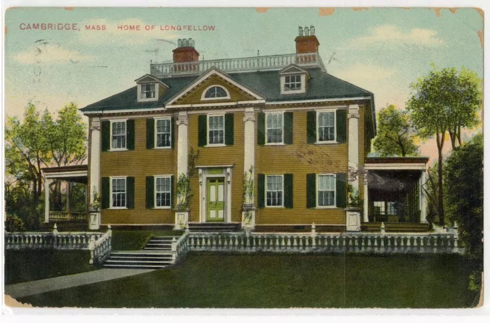
The 30-year-old Longfellow was also taken by a nearby estate, then owned by Elizabeth Craigie, which he called Craigie House. On his first visit he fell in love with the grandeur of the home, the tranquility of its surroundings, and its association with George Washington, who had a makeshift headquarters there during the Siege of Boston. Longfellow wrote of that first visit to the house, which stands on the traditional territory of the Massachusett people: “The window blinds were closed but through them came a pleasant breeze and I could see the waters of the Charles River gleaming in the meadows.” Three months later, he had become a boarder occupying two rooms of the Craigie House, where he boasted to friends and relatives that he lived “like an Italian Prince in his Villa.”
Despite the pleasure he found in his new accommodations, Harvard friendships, and vacations to the White Mountains and the coastal town of Nahant, Longfellow faced persistent melancholy from the loss of his wife. He expressed his sadness, and his hopes for better days, in “The Rainy Day,” which includes the famous line “in each life some rain must fall.” That poem was published in Ballads and Other Poems in late 1841. In the same book, Longfellow offers insight into how the natural environment could bring him profound comfort. The poem “To the River Charles” gives perspective into the long-lasting attachment to the waterway that shaped much of his life, work, and philanthropy.
In the poem, Longfellow references a place
Where yon shadowy woodlands hide thee
And thy waters disappear
Friends I love have dwelt beside thee
And have made thy margin dear.
It is likely that these lines refer to his wife’s grave at Mount Auburn Cemetery, which lies less than a mile upriver to the west. The solace he found in his view of the river paralleled that which he found at her graveside.

Thus began Longfellow’s lifelong love for the geography of Cambridge and its surroundings. Over the decades he spent in the city, he was motivated to conserve land for a variety of patriotic, historic, aesthetic, emotional, and health reasons. He adored the Craigie House for its ties to George Washington; its extensive gardens, where Longfellow took contemplative walks; its stately elms that cast shade over the poet on warm days; the sweetness of its fruit trees; and—especially—its views of the river, which brought Longfellow and his family tranquility, comfort, and joy.
Over his lifetime, Longfellow and his family were careful to steward the house and property to preserve its original character. This work led, eventually, to the creation and conservation of Longfellow Park and the Longfellow House–Washington’s Headquarters National Historic Site, as well as parts of Riverbend Park and Harvard University’s Soldiers Field athletic complex. Similar values motivated Longfellow’s contemporaries to protect other historical sites in Greater Boston, including Boston Common, the Bunker Hill Monument, Mount Auburn Cemetery, and several extensive private estates, such as the nearby Gore Place in Waltham.
Acquiring and Expanding the Estate
The event that most clearly lifted Longfellow’s spirits following his first wife’s death was the acceptance of his longstanding proposal of marriage by the woman who became his second wife, the young Boston socialite Frances (Fanny) Appleton. It was Fanny, and her father’s fortune, that formally united Longfellow with the Brattle Street property.
After their wedding on July 13, 1843, Fanny joined Longfellow in his room in the eastern half of the Craigie House, which by then he was subleasing from Joseph Worcester, who had leased the entire house from Mrs. Craigie’s heirs. Fanny immediately began to write home about the beauty of the house and grounds and the newlyweds’ love for the place. She more than hinted to her wealthy father, Nathan Appleton, that she might like to own the estate, as well as the surrounding acreage. She wrote to him, “If you decide to purchase this [Craigie House] would it not be important to secure the land in front, for the view would be ruined by a block of houses?”
Appleton could not resist his child’s wish. He purchased the house and the surrounding acreage for $10,000. The house and five acres were presented to the couple as a wedding gift. In the following decade, Longfellow purchased the balance of the surrounding land (approximately four acres on the south side of Brattle Street) from his father-in-law for $4,000. Over the years, the property’s history and its aesthetic and recreational value drove Henry and Fanny—and, later, their five children—to preserve it.

From the late 1840s to 1870, Longfellow continued to expand the property, purchasing adjacent land to preserve views and establish an inheritance for his children. He tacked on an additional 2.26 acres to the four-acre meadow south of Brattle Street and bought a 1.7-acre triangle of land wedged between Mount Auburn Street and the Charles River. He then began to divide the land among his children.
Longfellow’s friends living near Harvard likely approved of his landscape conservation efforts. Longfellow lived within walking distance of many important figures in the founding of the modern preservation and conservation movement in America, including Judge Joseph Story, a US Supreme Court associate justice and a founder of the Mount Auburn Cemetery; Edward Everett, who served in the late 1840s as the president of Harvard University and was a key supporter of the privately funded Bunker Hill Monument, the Mount Auburn Cemetery, and the preservation of Washington’s Mount Vernon estate; Oliver Wendell Holmes Sr., whose 1859 poetry commemorated the effort to raise funds to erect the equestrian statue of Washington that was eventually built in the Boston Public Garden; and James Russell Lowell, who in 1857 penned a proposal to create a society for the protection of trees in The Crayon.
Scrambling to Save the Meadows
In 1869, a slaughterhouse was proposed to be built across the river from the house, which threatened to sully Longfellow’s view of the water. Longfellow scrambled to organize a corporation to purchase the lot from under the developer. Within a year, the acquisition was complete. The corporation then donated the plot to Harvard College, with the stipulation that it remain as marshes and meadows, or be used for gardens, public walks, ornamental grounds, “or as the site of College buildings not inconsistent with these uses.” The land was adorned with the name Longfellow Meadows.
The land that Longfellow had been piecing together to leave to his heirs stretched all the way from his house to the north side of the Charles River. Longfellow Meadows, which Longfellow himself did not own, extended the scenic view on the south side of the river. Today, Longfellow Meadows is part of Soldiers Field, the Harvard University athletic complex. While not protected from all development, it maintains some open space and certain facilities, such as the track, that are open to the public.

In addition to conserving the land around his home through private acquisition or with special purpose corporations, Longfellow had an interest in more public conservation efforts. The archivist of the Longfellow House–Washington’s Headquarters National Historic Site, Kate Hanson Plass, reports that the site’s collections include two prints of the remarkable 1861 photographs of the Grizzly Giant sequoia in California taken by Carleton Watkins. The prints were sent east by Unitarian minister Thomas Starr King and lawyer Frederick Billings, both of whom were transplanted New Englanders with strong connections to literary, scientific, and political leaders of the era.
Prints sent to easterners in Boston, New Haven, New York, and Washington, DC, are believed to have played a key role in convincing Congress to protect western lands during the Civil War era. Abraham Lincoln signed the bill to create a state park at Yosemite in June 1864. Yosemite was the precursor to Yellowstone, the first true national park in the world, which Billings helped to create in 1872. Today there are national parks in nearly every country that is a member of the United Nations.
An Attempt to Save the Elms at Craigie House
The estate’s trees were another special interest of Longfellow, but his love for the property’s old elms caused him mostly heartache. In the late 1830s, the trees were afflicted with cankerworms. Longfellow described the infestation as a plague more troublesome than war, pestilence, or famine. In a lamenting letter to his father, he dreamed of sitting beneath their canopies “without being covered with creeping things, and brought daily like Martin Luther before a Diet of Worms.” Longfellow was desolate and spoke of rallying a “Society for the suppression of Canker Worms” to make “a regular crusade.”
He waged his own war on the pests, tarring the trees in hopes of ridding them of the worms. Joseph Worcester cut off the tops of the trees to try to arrest the infestation, but the effort was futile, Longfellow wrote: “Thus fell the magnificent elms which signalized the place and under whose shadow Washington had walked.”
In addition to honoring Washington’s memory, Longfellow was concerned with his own legacy. He dreamed of his descendants walking where he walked and savoring the same connection to place. In 1843, he planted a row of acorns, from which he hoped great oaks would grow. He wrote to his father, “you may imagine a whole line of little Longfellows, like the shadowy monarchs in Macbeth, walking under their branches for countless generations. . . .”

Longfellow repeatedly campaigned to prevent the City of Cambridge from cutting down trees along the sides of roads to make room for wider streets. Learning of Longfellow’s love for the trees, the children of Cambridge took up a collection to help pay for a special chair to be carved from the trunk of a chestnut tree that once stood in front of the blacksmith’s shop at 56 Brattle Street. This was the tree that had inspired Longfellow to write the line, “under the spreading chestnut tree, the village smithy stands” in the poem “The Village Blacksmith.” That chestnut wood chair, which was presented to Longfellow in 1872 on his birthday, now sits in the front study of the Longfellow House.
Stewardship as a Social Identity
With fellow 19th century artists and writers including Ralph Waldo Emerson, Emily Dickinson, and Henry David Thoreau voicing their reverence for nature, Longfellow tried his hand at nature writing, but this flavor of his work never earned the same acclaim as his other pieces. He also enjoyed styles of nature and landscape art that were gaining popularity among his peers. He traveled to exhibitions by the emerging group of Northeast-based landscape painters called the Hudson River School; attended artist lectures; and casually collected pieces in this style.
He was also influenced by his in-laws, the Appletons, who were avid art enthusiasts and may have encouraged Longfellow’s interest in the topic. One of Longfellow’s own pieces of work, “The Song of Hiawatha,” even shaped some of the art emerging at the time. Several prominent landscape painters, inspired by the epic poem, created notable works depicting its scenes. It is important to note that, while the poem is one of Longfellow’s most successful pieces, it is now considered to perpetuate cultural stereotypes and false narratives about Indigenous people.
There was an element of cultural conflict in the conservation movement at the time. A vein of anti-urbanism and anti-modernism ran through America’s mid-19th century elites. Both Henry and Fanny Longfellow wrote of their concern about the houses springing up around them, suggesting they felt protective of their exclusive enjoyment of the area. Similarly, Longfellow’s scramble to have the land across from his home purchased and conserved—not by him personally, but through a newly established corporation—is salted with not-in-my-backyard sentiments.
When a neighbor built a fence in the meadow across from the Longfellows, Fanny wrote that the structure grieved the family “whenever we glance at our lovely river.” Knowing that a house was slated to be built there as well, she lamented, “Is not this very vexatious? Until we came this neighbourhood was left in peaceful beauty, & now there seems a mania to build in every direction.”
Making Land the Longfellow Legacy
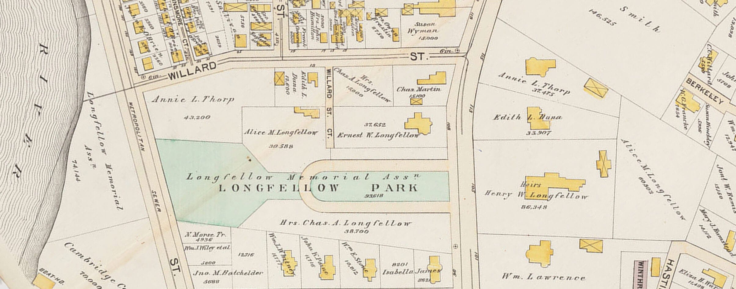
Longfellow’s values regarding the property lived on through his six children. To honor their father after he passed, they hoped to preserve a plot along the river as a memorial. When friends and colleagues of the poet incorporated the Longfellow Memorial Association to facilitate this plan shortly after his death, his children donated two parcels to kickstart its work, though they did not serve as members. The goal of the association was to erect a statue of Longfellow as a memorial and designate the land it stood on as a public park, to be gifted in trust to the City of Cambridge.

The children were more concerned with preserving the meadow as open space than they were with the monument itself. Ernest Longfellow wanted the area to be a “breathing space” on the river. He wrote that, as the city continued to grow more crowded, the park’s value as such would only grow and “would be a better monument to my father and more in harmony than any graven image that could be erected.”
However, the vision of the public that the surviving Longfellows hoped to serve may not have been entirely inclusive. As the park was designed and debate turned to the placement of their father’s monument, the children pushed back on recommendations for siting the statue. They worried that the suggested location would be too wet, and that the area was “not frequented by the same class of people” as others.
As a new century dawned, plans for Longfellow Park continued to develop. Upon donating the land, the Longfellow heirs stipulated that a road be built along the lot within five years. In 1900, Charles River Road—later renamed Memorial Drive and extended west along the river—was complete and was lined with plane trees. The Charles River Dam, finished in 1910, stabilized the area’s hydrology. The land was later incorporated into a linear park by the Metropolitan District Commission.
Some of the people involved in creating Longfellow Park went on to make notable contributions to conservation across the region. Charles Eliot, who helped design the park, later founded the nation’s first land trust, The Trustees of Reservations. He also led the establishment of the Metropolitan District Commission, whose first acquisition was the Beaver Brook Reservation in Belmont, Massachusetts, to protect the Waverly Oaks, a stand of 22 white oak trees. Only one of the Waverly Oaks remains, but the park is still home to impressive elder-growth trees, several of which may be much older than the park itself.
In the Care of Alice
Alice Longfellow, the poet’s eldest daughter, was one of only two heirs not to build a house on the estate after it was divided among the siblings. She lived in, and oversaw the upkeep of, Craigie House from 1888 to 1928. (Charles, the other heir who resisted building, was a world traveler with a downtown apartment on Boston’s Beacon Hill.)
Born at Craigie House, and raised in its rooms and gardens, Alice Longfellow had a connection with the home that was, perhaps, even deeper than her father’s and was fostered over a lifetime. The special affinity each of her parents held for the estate pulsed through their eldest daughter. The solemn and precocious child grew into a sharp-witted and capable woman who saw and responded to inequality in the world around her. She was a leader and advocate for opportunities in education for women and people of color and a philanthropist for schools for the blind.
Her political savvy also manifested in her conservation work. Her time as the estate’s matriarch marked an era of particularly lively community use. Alice hired the young and ambitious landscape architect Martha Brookes Brown (later Hutcheson), who refreshed and redesigned the gardens. The renovations restored some of the layout from the days when Henry Longfellow walked the grounds, but also made changes to better lend the area to social gatherings. When Alice traveled, which she often did, the house, porch, lawn, and gardens were all open to visitors. The space was often used for ceremonies, as a play area for children and dogs, as a baseball field, and as the grounds for an annual circus.
As the Longfellow children aged, they thought deeply about the future of the estate. They were concerned that future generations might not be well positioned to care for and preserve it. Alice was particularly articulate regarding these issues. After considering several options for preserving Longfellow’s home, the siblings decided on an Indenture of Trust, established in 1913. The trust transferred management of the estate to the Longfellow House Trust for the immediate benefit of the Longfellow descendants and the long-term consideration of the American people. Alice and other heirs could continue to reside in the house, but if and when they left, it would continue to be maintained.
After Alice Longfellow’s death, the trust became responsible for the estate and its maintenance. In the 1930s, the trust started to struggle financially and began a decades-long crusade to pass the house over to the National Park Service. The Longfellow National Historic Site was finally established by an act of Congress in 1972. It was later renamed Longfellow House–Washington’s Headquarters National Historic Site to preserve the memory of Washington’s time there during the Revolutionary War.
By the late 1800s, the waterfront had rapidly commercialized. The family parcel closest to the water was bounded by wharves, warehouses, a Cambridge Gas-Light Company structure, and the Cambridge Casino. The city undertook an ambitious riverbank improvement project two decades after Longfellow purchased the triangular parcel that became part of Riverbend Park. Without the family’s stewardship, it likely would have seen the same development that was being built nearby along the Charles River.
A Legacy and a Vision
Though it is only a portion of the property that once flourished under the Longfellow family line, the Longfellow House is—both historically and financially—more valuable than ever. Nestled amidst the built-up Cambridge of today, the house and gardens occupy two acres on Brattle Street, flanked by the Lincoln Institute of Land Policy and a campus of Lesley University.
The grounds are a National Historic Site and look out over Longfellow Park, another two-acre strip stretching from Brattle Street to Mount Auburn Street. Longfellow’s cherished river view has been partially obscured by Memorial Drive, which the city widened over time. Between Memorial Drive and the northern bank of the Charles River, another wedge of land escaped Cambridge’s rapid urbanization thanks to the Longfellow family. Today, the parcel is owned by the state Department of Conservation and Recreation. When Longfellow owned the property, it was marshy and prone to flooding. Today, it is grassy with a bank of woody shrubs and trees that thrive in stabilized hydrologic conditions engineered by the city.

Across the river, Harvard University students enjoy a sprawling athletic complex along Soldiers Field Road, thanks partly to Longfellow, who rallied friends and family to purchase 70 acres of the land in 1870 and subsequently donate it to the university. Back on the other side of the river and to the west, the Cambridge Cemetery and the adjacent Mount Auburn Cemetery complete, across several roadways, an arc of green that reaches from Cambridge into Boston and Watertown. With the nearby Fresh Pond reservoir as well as connective bike paths and the green median islands along Aberdeen Avenue, these protected landscapes form an expansive greenway in the midst of a busy, modern city.
The remarkable protected view of the Charles River from the Longfellows’ front parlor helped to frame what might be possible, through private and public action, across the nation, and around the globe.
Lily Robinson is a program coordinator at the International Land Conservation Network (ILCN), a program of the Lincoln Institute of Land Policy that connects private and civic sector conservation organizations around the world. She worked previously as a freelance reporter for the Harvard Press and CommonWealth magazine.
James N. (“Jim”) Levitt is director and cofounder of the International Land Conservation Network. He is a member of the Board of Trustees of Mount Auburn Cemetery.
The authors would like to acknowledge the remarkably helpful and dedicated staff of the Longfellow House–Washington’s Headquarters National Historic Site in Cambridge, Massachusetts, including Chris Beagan, Kate Hanson Plass, and Emily Levine.
Lead image: The Charles River rolls on. Credit: Artography via Shutterstock.