
La ciudad de Tegucigalpa, capital de Honduras, enclavada en un valle rodeado de montañas, alberga dentro de sus límites urbanos el Aeropuerto de Toncontín, uno de los aeropuertos más difíciles y peligrosos del mundo para las maniobras de despegue y aterrizaje. Por esto, a fines de 2016, Honduras comenzó la construcción de un nuevo aeropuerto en una antigua base aérea a 80 kilómetros al noroeste de la capital, con pistas más largas y una aproximación más confiable.
Cuando el nuevo Aeropuerto Internacional de Palmerola abrió sus puertas en 2021 en las afueras de la pequeña ciudad de La Paz provocó una explosión de urbanización en los alrededores, lo que ejerce más presión en el sistema hídrico de la zona, que ya se encuentra saturado.
Entre la afluencia de residentes que se acercan al aeropuerto y los nuevos negocios e industrias que surgieron en las cercanías, “se registra un crecimiento urbano exponencial”, explica Alfredo Stein, exprofesor de Planeamiento Urbano en la Universidad de Manchester, quien ahora es miembro de la junta ejecutiva con sede en Honduras del Instituto para el Desarrollo Urbano Internacional (I2UD, por sus siglas en inglés).
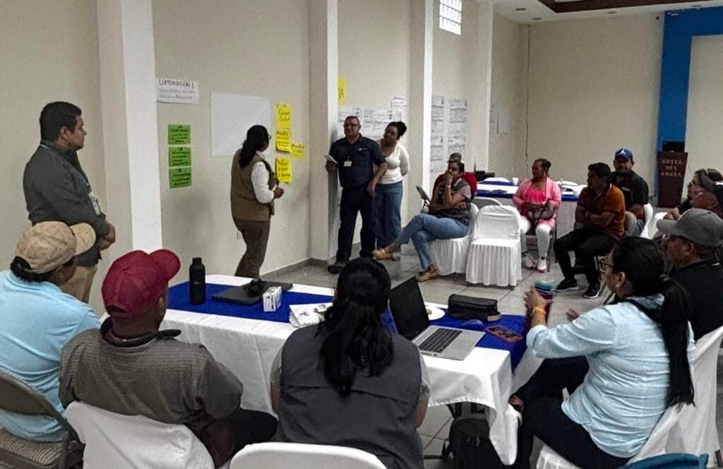
En abril, el I2UD, junto con la Asociación para el Manejo Integrado de Cuencas de La Paz y Comayagua y otras organizaciones sin fines de lucro, y con el apoyo del Consorcio para la Planificación de Escenarios y los programas de América Latina y el Caribe y Suelo y Agua del Instituto Lincoln, organizó un taller de planificación exploratoria de escenarios en La Paz con varios miembros de la comunidad, empresas privadas y funcionarios locales. Una meta principal del taller fue fortalecer la gobernanza colaborativa del agua en todo el sistema hídrico interconectado, desde las cabeceras de la cuenca superior hasta los barrios urbanos de la parte inferior.
Incluso antes del aumento en el consumo de agua producido por el nuevo aeropuerto y la expansión urbana descontrolada que trajo consigo, los residentes de la ciudad de la cuenca inferior, que incluye La Paz, solo tenían agua corriente durante parte del día debido a la escasez del suministro de agua y la infraestructura inadecuada, explica Giovanni Pérez Macías, quien ayudó a facilitar el taller. Mientras tanto, la cuenca superior de carácter más rural, que da origen a una gran parte del agua de la zona, cada vez alberga más cultivos para la producción de café. La agricultura es un importante motor de la economía hondureña, pero también es un uso del suelo que puede agotar y contaminar los suministros de agua.
Como ocurre en muchos lugares con sistemas hídricos rurales-urbanos interdependientes, la gestión de la cuenca está a cargo de diversas autoridades: en este caso son, en su mayoría, juntas hídricas locales con dirigencia barrial, que hacen todo lo posible para servir a sus propias comunidades. “Las personas que están en la parte inferior no son plenamente conscientes de las complejidades de conservar y producir agua terreno arriba y, a veces, no están dispuestas a contribuir para cubrir los costos de producción del agua que llega a la ciudad”, indica Stein. “Entonces, la idea del taller es cerrar esta brecha entre la cuenca superior y la inferior”.
Las dos regiones de la cuenca comparten desafíos similares de “gobernabilidad, cambio climático, cuestiones técnicas y financiamiento”, comenta Alejandra Mortarini, vicepresidenta de I2UD. “El problema es la falta de dinero en la parte superior, por lo que alguien tiene que aportar para sostener el trabajo que se realiza en la cuenca superior”.
Ante el impacto que el nuevo aeropuerto ejerce en la región, Stein se pregunta si una tarifa por pasajero, algo que, en su opinión, tuvo éxito en Costa Rica, podría ayudar a financiar la gestión de la calidad del agua, la conservación y la infraestructura. O tal vez sería posible persuadir a los productores de café y las empresas urbanas para que paguen más por una garantía de servicio de agua continuo.
“Si quieren seguir operando, necesitarán agua, por lo que es necesario establecer un cierto fondo local para el mantenimiento de este proceso de producción de agua”, explica Stein. “¿Será una tasa, un impuesto? La ley municipal en Honduras permite que se implementen muchas de estas alternativas financieras”.
Los talleres también exploraron estrategias a largo plazo para garantizar una mayor resiliencia a los riesgos climáticos. “Hubo un aumento bastante drástico en la demanda de agua, y esto sucede en el contexto de impactos climáticos graves”, agrega Stein, desde períodos de sequía más frecuentes hasta lluvias más intensas que causan inundaciones. “Tenemos estrés hídrico, un aumento en la demanda de agua, una disminución de las fuentes de agua, un cambio drástico en el uso del suelo, incendios forestales, explosión demográfica: esos son los problemas que pretende abordar este taller de planificación de escenarios”.
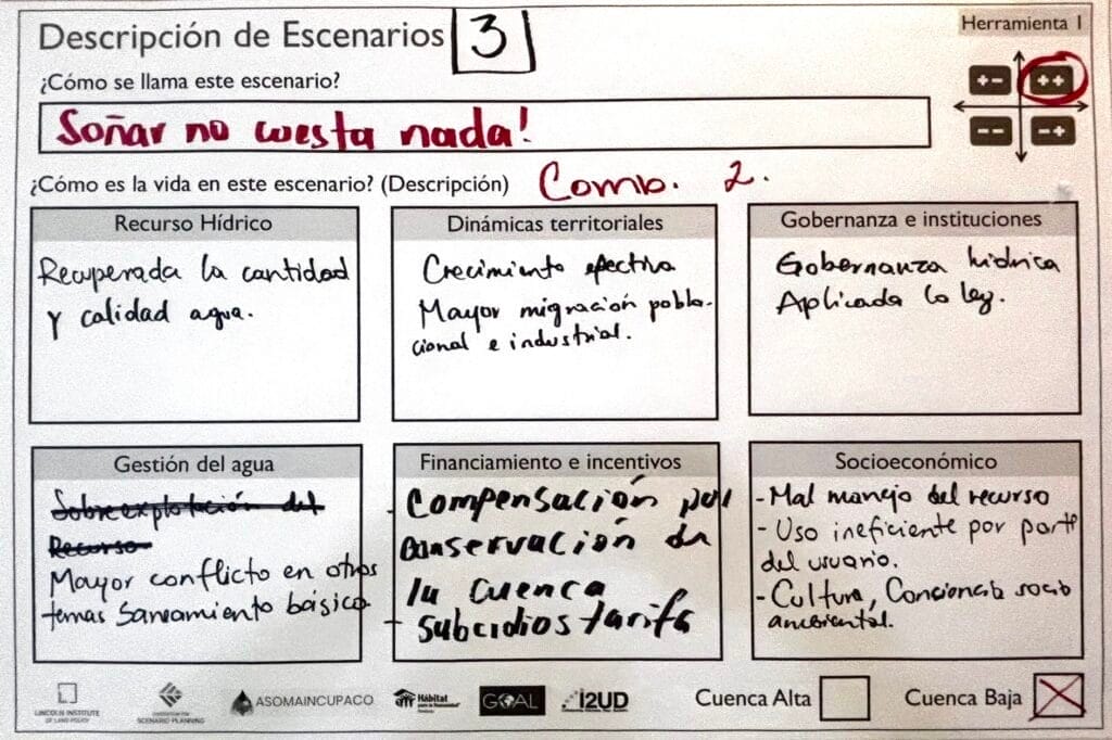
Los organizadores (otros socios incluyeron Hábitat para la Humanidad Honduras y Goal Honduras) llevaron a cabo una serie de talleres previos a la sesión de abril para ayudar a que los miembros de la comunidad identifiquen un conjunto de fuerzas impulsoras y escenarios futuros, a fin de que los asistentes los consideren juntos con más detalle. El marco de planificación exploratoria de escenarios ayudó a crear un entorno de apoyo para tener conversaciones que pueden ser incómodas, comenta Pérez Macías. “Hablar sobre el futuro de una comunidad resulta ser un espacio común . . . Es algo que todos compartimos”. De hecho, el título de uno de los escenarios era “Soñar no cuesta nada”.
Al final del taller de un día y medio en abril, “sucedió algo realmente sorprendente”, agrega Pérez Macías.
“Siempre existe el riesgo de que las estrategias finales estén, en cierta forma, fuera del alcance de la comunidad”, explica. “Como: ‘necesitamos una nueva ley nacional’ o ‘necesitamos USD 10 millones’. Así que les pedimos que piensen en estrategias que estén bajo su control. Y sucedió lo siguiente: decidieron que la primera estrategia era que este grupo de personas continuara conversando sobre el agua e intentara construir una junta hídrica local con diferentes representantes de la cuenca superior, la cuenca inferior, las ONG y los grupos gubernamentales y económicos de la región”.
Ese tipo de resultado tangible es lo que puede hacer que la planificación de escenarios sea una herramienta tan efectiva para las comunidades que enfrentan desafíos complejos e interconectados, explica Heather Hannon, directora de Práctica de Planificación y Planificación de Escenarios en el Instituto Lincoln. Como ejercicio de visión comunitaria, “está diseñado para dar lugar a nuevas formas de pensar sobre el futuro, pero también para estimular acciones y compromisos significativos en el presente”, agrega.
El taller de La Paz fue uno de los cinco proyectos centrados en el uso de la planificación exploratoria de escenarios (XSP) para enfrentar los desafíos hídricos en América Latina seleccionados para recibir apoyo a través del Consorcio para la Planificación de Escenarios y el programa de América Latina y el Caribe del Instituto Lincoln.
“En toda América Latina y el Caribe, las comunidades enfrentan presiones crecientes en torno al agua, el uso del suelo, la variabilidad climática y la gobernanza”, indica Kristen Keener Busby, directora asociada de Implementación de Programas del Centro Babbitt de Políticas de Suelo y Agua del Instituto Lincoln. “Uno de los aspectos más valiosos de estos talleres es la creación de un espacio para que diversas partes interesadas exploren juntas la incertidumbre mientras identifican vías prácticas con base local para alcanzar la resiliencia a largo plazo”.
Los otros cuatro proyectos seleccionados, que también están en marcha, incluyen los siguientes:
- Un consorcio de investigadores de Bogotá, Colombia, está utilizando el marco de planificación exploratoria de escenarios para abordar las presiones climáticas, ambientales y de uso del suelo en la laguna de Suesca en Suesca, Colombia, y sustentar el plan de manejo de la laguna, fortalecer la colaboración entre las comunidades y la autoridad ambiental, y desarrollar enfoques escalables para la gobernanza resiliente.
- En México, el Instituto de Planeación y Gestión del Desarrollo del Área Metropolitana de Guadalajara (IMEPLAN) está ejecutando un proceso de XSP centrado en los riesgos de inundación a fin de mejorar la gestión de las aguas pluviales y fortalecer la resiliencia; el proceso culminó con la implementación de un plan de gestión de inundaciones a largo plazo para el área metropolitana.
- Aquafondo, con sede en Lima, Perú, reunirá a las comunidades de la subcuenca de Santa Eulalia para el desarrollo conjunto de escenarios futuros para la gobernanza hídrica y la gestión territorial, y la identificación de enfoques a largo plazo para fortalecer la resiliencia del agua en toda la cuenca ante la incertidumbre institucional y un clima cambiante.
- Para abordar la creciente escasez de agua en la cuenca del río Mendoza en Argentina, CONICET Mendoza, en coordinación con las organizaciones locales de usuarios de agua, empleará XSP con el objetivo de fomentar la toma de decisiones participativas para la gestión equitativa y sostenible del agua entre los usos que compiten entre sí.
Obtenga más información sobre solicitudes de propuestas, becas y oportunidades de investigación del Instituto Lincoln.
Jon Gorey es redactor del Instituto Lincoln de Políticas de Suelo.
Imagen principal: Horizonte nocturno aéreo de Tegucigalpa, Honduras, desde el parque El Picacho. Crédito: Leonid Andronov vía Getty Images.


