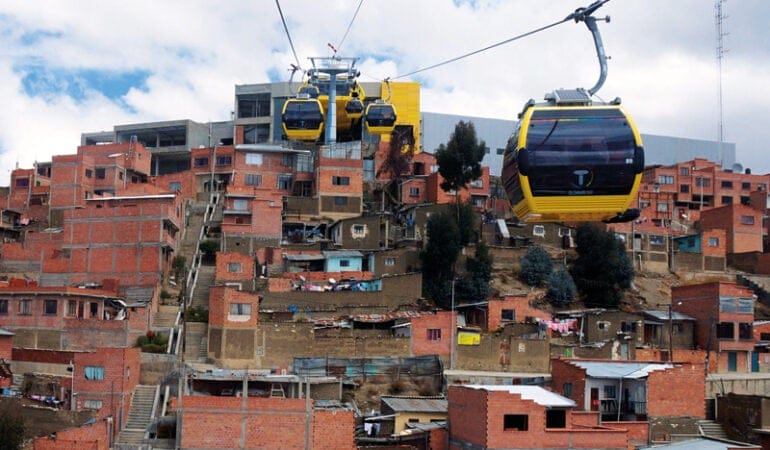
Today an indigenous Bolivian produce vendor glides through the air on an aerial cable car to reach the market in La Paz. A student in Bogotá, Colombia, knows she will arrive on time for class because the city’s bus rapid transit (BRT) network never gets stuck in traffic. A car owner in São Paulo, Brazil, leaves the keys at home because the city’s ban on rush hour driving in the city center applies to his license plate number that day. A young middle-class family lives comfortably without a car in downtown Santiago, Chile, thanks to new sidewalks and bike lanes for neighborhood trips and a clean, safe combination of subway and BRT to navigate the rest of the city. And a day laborer in Rio de Janeiro’s favelas can count on a shared van that serves his neighborhood when the city’s official bus system does not.
These slices of life in Latin America’s big cities are not unusual. Bus rapid transit (BRT) lines zip through the heart of 54 cities in the region. Aerial cable cars connect steep hillside neighborhoods with the rest of town in over a half-dozen cities. Pedestrians and cyclists of all social classes are increasingly finding their way on busy urban streets. Informal transit options abound, although their safety and reliability vary widely, as does tolerance from public officials. Subway systems are being built out, albeit slowly. Car ownership remains well below averages in the developed world.
Altogether, Latin America has earned a reputation as a global innovator in urban transit. Latin American cities have garnered 9 of the 16 annual Sustainable Transport Awards given by the Institute for Transportation and Development Policy (ITDP), and they regularly place as finalists in the C40 Cities4Mobility Awards.
There have been some impressive successes. Public-private partnerships (P3s) are now de rigueur across the region: national governments are funding infrastructure and overseeing long-term plans while private firms bid to operate routes. The World Bank estimates that Latin America invested $361.3 billion for energy and transport infrastructure in more than a thousand P3s over the last decade, with the lion’s share in Brazil, Colombia, and Mexico. Meanwhile, Brazil and Colombia have deployed land value capture in order to finance the expansion of BRT networks and the construction of new rail lines (Smolka 2013).
Amid the Latin American transport boom, however, there have also been busts. Overcrowding on Bogotá’s TransMilenio system, the region’s largest BRT network, has led to periodic riots. Rio staked its Olympic legacy on enhanced mobility with a citywide build-out of BRT and three aerial cable cars to serve favela communities, but endemic corruption and top-down planning resulted in unkept promises. The zeal to implement new transit corridors in places like Quito, Ecuador, has come at the expense of informal operators serving the poorest urban dwellers.
“Latin America is innovating, but we still don’t know if that innovation brings a virtuous cycle to generate resources for the city,” said Clarisse Linke, director of ITDP’s Brazil office. “Are we benefitting the poor so they don’t have to travel 50 kilometers each way to work?”
Such questions are at the heart of Latin America’s transportation innovation paradox. The region may have invented creative ways to move people around crowded urban centers, but can it deliver on a broader need to reduce crushing inequality? When it comes to that level of innovation, the awards jury is still undecided.
BRT Boom
Transportation innovation has flourished in Latin American cities, primarily due to two factors: rapid urbanization and extreme inequality. Despite improvements in recent decades, 8 of the 20 least equal countries in the world, as measured by the Gini index, are in Latin America. And demographers consider the region the most urban in the world. Eighty percent of its population resides in cities, and rates are even higher in Argentina, Brazil, and Chile. Those teeming cities emerged during a postwar economic boom that sparked massive rural-to-urban migration. As peasants, farmers, and indigenous people came down from the Andes or left the arid hinterlands of northeastern Brazil, they did not encounter a ready supply of inner-city housing. Instead, they were shunted to the edges of cities or onto steep hillsides unsuitable for construction.
Seas of poor people surrounding islands of affluence became the socioeconomic norm in the region (Gutman and Patel 2018). New arrivals to a city often find centrally located jobs as maids, janitors, construction workers, or cooks. This creates a need to move large numbers of low-wage workers relatively long distances, to where they can afford to live.
Plenty of enterprising options have sprung up to meet the demand. Shared vans or taxis, known as colectivos (Spanish) or kombis (Portuguese), began plying routes to serve new neighborhoods that overburdened municipal governments couldn’t reach or intentionally neglected. Privately operated bus fleets popped up, offering frequent but uncoordinated service that saw companies competing against each other and drivers competing against the clock in ways that left gaps, duplication, and unsafe conditions.
In the late 1960s and early ’70s, the cash-strapped public sector used its limited resources to invest in rail networks in only the biggest cities. Subways in Mexico City, São Paulo, and Santiago are prime examples from this period. Although they serve millions of passengers daily, they don’t compare well to the comprehensive rail networks of similarly sized megacities like London and Tokyo.
Enter bus rapid transit. While the idea is credited to British urban planner Peter Midgley, a retired World Bank consultant who devised the first dedicated bus lanes in French and Belgian cities in the late 1960s, it was Curitiba, Brazil, that evolved the first BRT system. The 20-kilometer line that opened in 1974 featured not just dedicated bus lanes, but also enclosed stations, pre-boarding payment, and all-door boarding—features that make subways swift and convenient.
Curitiba’s then mayor, architect Jaime Lerner, who became famous for his urban design interventions in the southern Brazilian city, had federal funding for a metro line. But he realized that the city could produce a much longer dedicated bus system for the same price as a much shorter subway line. With bus stops that had the look and feel of subway stations, and zoning that allowed taller buildings on major corridors near the stations, Curitiba gained most of the benefits of a subway line with a limited budget.
That basic approach appealed to Latin American cities. “We didn’t have the resources or the time to implement rail-based transport,” said Linke. “It was an urgent situation because our cities were already heavily populated, and we needed more transit coverage.”
The model evolved in Bogotá under Mayor Enrique Peñalosa—who is back in office after a 14-year hiatus. The city of 8 million is conspicuously absent from the list of Latin American metropolises with subway systems, because Peñalosa, like Lerner, invested heavily in BRT instead in the late 1990s. Bogotá’s TransMilenio system grew to become one of the largest BRT networks in the world. With 210 kilometers of routes and over 2 million passengers daily, the TransMilenio rivals many underground networks.
Curitiba and Bogotá represent something of the golden era for Latin American BRT, as these two cities proved, at least for a time, that they could transport a critical mass of residents for a fraction of the cost of heavy rail, sparking a worldwide trend. Meanwhile, cities like Santiago, São Paulo, Rio, Mexico City, and Quito moved to implement BRT lines as a complement to trains, mostly filling in gaps rather than building out rail networks.
BRT, in turn, became identified with Latin America in transportation and policy circles. Think tanks like the Brookings Institute held seminars on what US public transportation could learn from the Latin American BRT boom. The World Resources Institute (WRI) championed BRT as a Latin American innovation and identified Latin America as home to the bulk of the world’s BRT passengers, nearly 20 million people daily.
Middle of the Road
While the global fervor around BRT continues, unabashed boosterism has been tempered by growing criticism, and Bogotá’s TransMilenio has been the main lightning rod. The system’s approval rating has plummeted from 90 percent to around 20 percent, with chronic overcrowding the main complaint. Like Tokyo’s infamously overcrowded mass transit system, TransMilenio is designed for 6 people per square meter—compared to Sweden’s transit design standard of 2 per square meter or New York City’s average of 2.7 per square meter. This means passengers are squeezed so tightly they may not be able to disembark at their stop. And the system routinely carries as many as 8 or 9 people per square meter, so at peak times it can take 45 minutes just to find a bus with room to board.
While the city continues its efforts to shore up TransMilenio, most recently announcing $8 million to enlarge 49 of 138 stations so they can accommodate more passengers, the system’s flaws have driven more Bogotanos to alternate modes of transportation. The increased reliance on private cars and taxis has produced the sixth-worst traffic congestion on the planet, according to the INRIX 2017 Global Traffic Scorecard. And after 60 years, Bogotá is finally poised to invest in a metro line.
“Today we celebrate that we reached a point of no return with the Bogotá Metro,” said Peñalosa last September when Colombian President Juan Manuel Santos approved national funding for the project. Transportation officials determined that a 30-kilometer subway system powered by renewable hydroelectric energy was preferable to more BRT, which has been slow to convert to clean electric buses from dirty diesels.
Some still favor the cost benefits of BRT. Colombian transportation economist Juan Pablo Bocajero at the University of the Andes estimates that the city loses $800 million annually (0.5 percent of its GDP) to traffic congestion. “If I had to decide between a 30-kilometer subway and a 200-kilometer BRT, I would probably choose the BRT,” he told Public Radio International’s The World in 2015. But even TransMilenio diehards like the system’s former deputy general manager, Dário Hidalgo, who now coordinates WRI’s Observatory of the BRT Center for Excellence, have publicly supported the Bogotá metro.
The BRT versus metro debate also played out in Brazil, where both Porto Alegre and Curitiba considered subway lines after receiving a huge injection of capital from the federal government’s public infrastructure spending campaign, much of it funneled into 2014 World Cup host cities. While on paper both opted for a subway, favoring higher capacity and ribbon-cutting potential over the cost-benefit efficiency of BRT, Brazil’s political and economic crisis over the last few years has led both cities to suspend their projects. Curitiba has petitioned the federal government for permission to redirect its roughly $500 million federal grant back into the city’s flagship BRT system.
Nonetheless, transit investment is not a zero-sum competition, notes Daniel Rodriguez, a University of California, Berkeley scholar and Lincoln Institute fellow, citing research on US metropolitan areas (Levine 2013). Overall, spending on different modes of transit tends to rise and fall together, and spending on one mode has a neutral or complementary effect on another.
Aerial Cable Cars
A more recent innovation reflects a willingness to invest in poorer neighborhoods shaped by the unique topography of Latin American cities, where informal settlements often cling to hillsides. As Curitiba inspired a BRT boom, the aerial cable car inaugurated in Medellín in 2004 likewise inspired a half-dozen other Latin American cities. At a cost of $5 to 10 million per kilometer, it compares favorably with rail transport that couldn’t necessarily navigate the formidable terrain above Medellín’s valleys or between high-altitude El Alto and La Paz. Cable cars have slashed travel times in complicated areas previously navigable only by motorbikes, pedestrians, and small vehicles. But there are notable exceptions: Rio’s two cable car lines have been shuttered for over two years after corruption probes discovered that construction firms colluded with public officials to overcharge for the projects by tens of millions of dollars.
While the public sector debates the merits of BRT, private bus fleets continue to serve every Latin American city, and local governments have tried with mixed success to rein in the chaotic overlapping networks of buses. In 2007, Santiago’s publicly subsidized, privately run Transantiago introduced smart cards, scrapped old modified trucks in favor of new buses, and brought the entire system under the authority of one agency. But commuters felt frustrated that the radical reform—considered the most ambitious in the transport sector of a developing country—was imposed on them too rapidly. Although Santiago’s system was more reliable than many Latin American cities’ overall transport networks, in 2017 the think tank Espacio Público called it the worst public policy decision since Chile’s return to democracy, in large part because of the billions of subsidies the government pays to private bus operators to keep the system running.
The inadequacies of Santiago’s BRT stemmed in part from an initial lack of public subsidies for the private bus companies, according to Rodriguez. “This translated into operators attempting to carry as many passengers as possible,” he said. The city also eliminated many existing routes and failed to inform riders of the changes (McCarthy 2007).
Such questionable public policy decisions could be a contributing factor to Latin America’s rising car ownership rates (Roque and Masoumi 2016). Still, a recent study showed car ownership rates below the averages in wealthier countries, from a low of 71 per 1,000 residents in Ecuador to a high of 314 per 1,000 residents in Argentina. Those relatively low numbers mean that a large constituency favors an increase in bus lanes at the expense of private car lanes.
But the annual growth rate of car ownership—up to 6.1 percent in Chile—far outpaced the 1 to 2 percent range in developed nations. These figures suggest that despite Latin America’s advances in mass transit, the upper class and upwardly mobile are still opting for private automobiles, regardless of traffic congestion. (Nine Latin American cities feature in the INRIX 100 cities with the worst traffic, more than in Asia and Africa combined.)
On the other end of the economic spectrum, the proliferation of BRT may be having other consequences. “BRT is the flavor of the decade in transportation and it is supplanting, in some cases problematically so, existing transport systems that are problematic in their own right,” said University of California, Berkeley scholar Daniel Chatman, who has studied the impact of new BRT routes in several cities, including Quito and Barranquilla, Colombia.
Preliminary research suggests that BRT in high-volume corridors tends to best serve those working in traditional office settings, moving them from dense, formal residential areas to job centers. That can leave the poor behind as ancillary routes through poorer parts of the city are cut off by transit planners aiming to formalize the existing transportation network, even though it underserves the 30 percent of the region’s residents who live in informal housing.
“BRT ends up serving the dominant traffic pattern in a city and doesn’t necessarily deal as well with other travel patterns that are not part of this main trunk system,” Chatman said.
BRT’s ability to move people over long distances has also facilitated worsening socio-spatial segregation. After creating access to land on the urban periphery, housing officials and private-sector developers in Brazil, Colombia, and Mexico moved to build social housing ever farther from the city center in order to take advantage of lower land prices.
“We now know this was a mistake, leading to social exclusion, higher fares, and travel burden,” said University of California, Berkeley’s Rodriguez.
The prevailing spatial structure of Latin American cities, with low-income residents located predominantly in the outskirts, means that BRT projects have largely benefitted middle-income residents. This is true in Bogotá (Combs 2017) and Lima (Scholl et al. 2017), where BRT serves concentrations of middle-income residents, connecting them to formal employment clusters. Residents of social housing in Brazil pay over 50 percent of their income on housing and transportation combined, while occupants of more centrally located housing pay 39 percent, according to Linke.
Urban Transportation in Latin America
In May 2017, the Lincoln Institute and the University of California, Berkeley’s department of city and regional planning hosted a symposium on urban transportation in Latin America. It focused on the influence of innovative transit schemes on real estate, urban development, and the lives of city residents. The aim of the symposium was to examine the evidence to date and discuss ways to apply recent scholarship to public policy.
Symposium papers paint a complex picture of experiences and impacts. Research was inconclusive about whether BRT investments can have distinct impacts on real estate markets, although most of the studies have focused on just a few cities in Colombia, Ecuador, and Mexico. Aerial cable cars have been empirically studied only in Medellín, which showed increased real estate activity. Both types of transport have led to increased building permit activity and population density. Land use trends shifted from residential to commercial in Bogotá and Quito but not in León, Monterrey, Guadalajara, and Puebla. Inconsistencies regarding estimated impacts point to differences in local conditions. Urban land markets are subject to a variety of forces—from planning institutions and development activity to the availability of land—that are likely to influence the price of land, making it difficult to generalize price impacts within corridors, across corridors, and over time.
Opportunities for further research abound, including studies of the importance of these innovations relative to established urban transportation modes, how to target the benefits towards the poorest residents, and how to better coordinate with land development.
The high cost and inconvenience also reflect poor coordination between housing and transit planning. As a result, housing is often located without consideration for transit access, notes Enrique Silva, associate director of the Lincoln Institute’s Program on Latin America and the Caribbean. BRT’s failure to reach more underserved communities is the result of discrete choices of “how you plan your routes and how accessible the stops are to people,” he said. Planners decided to work on existing major routes and decided not to extend or consider routes that penetrated more effectively into poor neighborhoods, Silva explained.
Latin America’s advances are nevertheless impressive, and moving around cities in the region has improved demonstrably in recent decades. But until the region reduces the vast gulf between rich and poor—a division that manifests itself in where people can live—high-speed transit can serve at best as a salve on a deeper wound.
Gregory Scruggs, AICP, writes about cities and culture in the Americas. He is a correspondent with the Thomson Reuters Foundation, and his work has appeared in the New York Times, Washington Post, Atlantic CityLab, and The Guardian.
Photograph: Gwen Kash
References
BRTData. www.brtdata.org.
Combs, Tabitha. 2017. “Improving Equity in the Distribution of Public Transit Benefits.” Paper presented at the Symposium on Transportation Innovations and Urban Land in Latin America, Berkeley, CA, May 2017.
Gutman, Jeffrey, and Nirav Patel. 2018. Addressing Spatial Inequality in Latin American Cities. Washington, DC: Brookings Institution. www.brookings.edu/research/addressing-spatial-inequity-in-latin-american-cities.
Levine, Jonathan. 2013. “Is Bus Versus Rail Investment a Zero-Sum Game? The Misuse of the Opportunity-Cost Concept.” Journal of the American Planning Association 79:1, 5–15. DOI: 10.1080/01944363.2013.785285.
Linke, Clarisse, and Luc Nadal. 2017. “Housing, Transport and Access: A Case for Transit-Oriented Low-Income Housing in Rio de Janeiro.” Paper presented at the Symposium on Transportation Innovations and Urban Land in Latin America, Berkeley, CA, May 2017.
McCarthy, Julie. 2007. “In Chile, Commuters Sue City over Transit System.” Broadcast on All Things Considered, National Public Radio, October 8, 2007. www.npr.org/templates/story/story.php?storyId=15100976.
Rodriguez, Daniel A., Erik Vergel-Tovar, and William F. Camargo. 2016. “Land Development Impacts of BRT in a Sample of Stops in Quito and Bogotá.” Transport Policy 51: 4–14. DOI: 10.1016/j.tranpol.2015.10.002.
Roque, Daniela, and Houshmand E. Masoumi. 2016. “An Analysis of Car Ownership in Latin American Cities: A Perspective for Future Research.” Periodica Polytechnica Transportation Engineering 44(1): 5–12. DOI: 10.3311/PPtr.8307.
Scholl, Lynn, Daniel R. Oviedo, Marco Innao, and Lauramaria Pedraza. 2017. “BRT Systems and Social Inclusion: Impacts on Access to Jobs—The Case of Lima, Peru.” Paper presented at the Symposium on Transportation Innovations and Urban Land in Latin America, Berkeley, CA, May 2017.
Smolka, Martim O. 2013. Implementing Value Capture in Latin America: Policies and Tools for Urban Development. Policy Focus Report. Cambridge, MA: Lincoln Institute of Land Policy.
Velandia Naranjo, Durfari Janive. 2017. “The Impact of Bus Rapid Transit System on Land Prices in Mexico City.” Paper presented at the Symposium on Transportation Innovations and Urban Land in Latin America, Berkeley, CA, May 2017.
Vergel-Tovar, Erik. 2017. “The Impacts of Bus Rapid Transit on Land Use and Real Estate Activity in Bogotá, Colombia.” Paper presented at the Symposium on Transportation Innovations and Urban Land in Latin America, Berkeley, CA, May 2017.

