WPA 2.0
This feature is adapted from Nature and Cities: The Ecological Imperative in Urban Design and Planning, edited by Frederick R. Steiner, George F. Thompson, and Armando Carbonell (Lincoln Institute of Land Policy, November 2016).
During the past 400 years, the land known as the United States of America has been transformed by massive public and private works projects and technological innovations intended to facilitate commerce, improve public health, and foster economic development. While these projects generated tremendous wealth for the nation, the gains were often to the detriment of the environment. The global realities of climate change—in combination with growing urbanization and associated poverty—have raised awareness of the ecological impact of such infrastructure. Americans are now at a unique moment in history when politics, economics, ecology, and culture (design) can all be part of a new movement. We need a WPA 2.0.
The WPA is the Works Progress Administration (1935–1943)—the largest and most ambitious program of U.S. President Franklin D. Roosevelt’s New Deal during the Great Depression. Much of the present-day infrastructure in the United States was built by either the WPA or the similarly named PWA (Public Works Administration). Almost every city, town, and community in America benefited from a new WPA- or PWA-built airport, bridge, dam, park, road, school, or other public building.1
Let me now reflect, albeit briefly, on the history of public works projects in the United States to discern where the world’s richest nation is, today, in terms of its urban infrastructure. This will allow a glimpse into how landscape architects, architects, and planners are addressing the needs and opportunities that face not only American cities, but communities and cities throughout the world as they confront the pressing realities of global climate change.
Canals and Harbors
Early settlement in the United States showed patterns of towns and cities directly related to water resources. Navigable waterways, safe harbors, and access to fresh water for fire prevention, sanitation, power production, farming, and drinking were central to the development of major commercial centers. Construction of the Erie Canal (1817–1825), for example, made New York the financial capital of the world during the nineteenth century by opening up critical supply lines for timber, furs, minerals, and agricultural products that helped the North win the American Civil War (1861–1865). Since then, we have seen the gradual decoupling of urban transportation systems from the physical environment in the United States.
The Grid
Looking back to nineteenth-century America, ideals of Manifest Destiny and the agrarian myth fueled a need to organize and cultivate the nation’s western frontiers. The Land Ordinance Act of 1785 was a resolution written by Thomas Jefferson (1743–1826), then a delegate from Virginia, to create a federal system for the survey and sale of federally owned land west of the Appalachian Mountains, intended to fund the federal government at a time when the government could not raise fiscal resources through taxation.2 It was then that an uncoupling of environmental and development systems started to take place on a large scale: The public land survey system parceled land into gridded territories, townships, and sections without regard to the geomorphology or carrying capacity of the property. Territories (24 x 24 miles; 38.624 x 38.624 kilometers), townships (6 x 6 miles; 9.656 x 9.656 kilometers), and sections (1 x 1 mile; 1.609 x 1.069 kilometers) were numbered and organized boustrophedonically, an alternating pattern from the top right to the bottom left quadrant of a square, similar to the path a farmer might follow when plowing a field.3
Agriculture, Railroads, and the Grid
When Horace Greeley (1811–1872), the famous editor of The New York Herald Tribune, purportedly declared in an editorial (13 July, 1865), “Go West, young man, go West and grow up with the country,” he rallied the nation.4 Greeley was responding, in part, to the Homestead Act of 1862, which enabled veterans, freed slaves, and even women to file a claim to a half-section of land (640 acres; 260 hectares) if they agreed to live on it and improve it for five years, further promoting agrarian values that were part of an American nationalism, which developed during a time of rapid industrialization. Manifest Destiny and agrarian culture, as characterized decades earlier by de Crèvecoeur (1735–1813) in numerous books, mythologized farming, espousing rural life as the foundation of character.5 However, the gridding of America and subsequent development of national rail lines—enabled by government grants of more than 300 million acres (121,405,693 hectares) to rail companies—were not reliant on natural systems for their development; instead, both worked in opposition to the waterways and topography they encountered, some of them extreme.
Supremacy over the landscape had its limits. While rail lines could be drawn to previously inaccessible corners of the country, facilitating commerce, they required long, gradual grade change and abundant clean water to function, limiting universal access. Farms and towns located themselves on and near new rail lines, but land in more arid climates west of the 100th meridian did not have the carrying capacity characteristic of Thomas Jefferson’s Virginia.6 Parcels of half-sections needed to be combined and annexed to enable productive use for timber or cattle grazing, uses that have their own heavy impacts on indigenous landscapes. The scale of operations moved toward a more standardized practice, away from the ideals of the rural farm. Western settlers and transcendentalists alike thought nothing of the consequences of introducing nonnative plant communities to the detriment of the indigenous environment.
A hallmark of the Industrial Revolution in the United States was the first transcontinental linking of rail lines—the Union and Central Pacific Railroads at Promontory Summit in Utah Territory near present-day Brigham City—on 10 May, 1869. Infrastructure tied to natural systems for the first two and a half centuries of the nation’s development could now follow a much more flexible path. By 1910, there was a network of more than 250,000 miles (402,336 kilometers) of rail covering the United States. Coeval with this infrastructural growth, the nation’s waterways transitioned from being critical economic lifelines to convenient disposal sites. As Carolyn Merchant has observed, “In the United States, industrial chemicals and wastes, including sulfuric acid, soda ash, muriatic acid, limes, dyes, wood pulp, and animal byproducts from industrial mills contaminated waters in the Northeast.”7 Ongoing pollution of rivers, canals, and ports still leaves neighboring communities managing the consequences of years of environmental abuses, despite the benefits of the 1972 Clean Water Act.
As natural systems became less important for access, they remained critical for raw materials. The relationship between water rights and rail lines, for instance, was critical not only because clean water was necessary to power steam engines, but also because the relationship between agriculture and rail transport systems opened up new areas of the country for the development and trade of commodities such as corn and wheat, legacy crops to this day.
Combined Sewers
When English plumber Thomas Crapper (1836–1910) popularized the use of the flush toilet during the 1860s, he surely had no idea of the potential future impact upon municipal watermanagement systems. His work triggered a cascade of events leading to the degradation of global waterways 150 years later. Rapid urbanization in the United States during the nineteenth century created the need for collective management of sanitary waste. In search of innovation, the United States looked to Europe, where a new form of infrastructure—the combined sewer—was developed to manage increased sanitary waste coming from more flush toilets. Combined sewer overflows (CSOs) release a witch’s brew of surface-water runoff and sanitary sewage into neighboring waterways when there is too much effluent for treatment plants to manage. Today, New York City, like 772 U.S. cities, has a combined sewer system where—in even a light rain—sanitary and storm wastes combine, releasing excrement, prophylactics, oil, pesticides, and heavy metals into New York’s harbor and rivers.
Around the world the combined sewers that unite sewage and stormwater in a common pipe—once a transformative infrastructure solution—have reached their limit. Growing urban populations and increased impermeable surfaces perpetually overload the sewage-treatment systems in cities globally. With sewage ever more frequently overflowing into waterways and a rise in sea level further compromising the outfall systems, policy makers and even private funders need to empower designers to rethink the design and management of urban stormwater and sanitary water systems. More severe and frequent storms resulting from global climate change will increasingly affect the hardened, postindustrial waterfront. Innovative urban design that can dissipate the forces of storm surge, manage flooding, reduce surface-water runoff, and reduce a heat-island effect need to be worked into an adaptation plan for waterfront cities. Without major changes to technology, the natural and human resource management of global health and productivity will be compromised.
The New Deal
Beginning in 1933, during the depths of the Great Depression, political leaders in the United States put forward programs under the New Deal that offered targeted relief for the massive number of unemployed and poor Americans, gradual recovery in the economic sector, and reform of the financial system. Significantly, New Deal programs also transformed the nation’s critical infrastructure. Roads, water-management structures, and pathways for electrification provided access, sanitation, and power to formerly undeveloped areas of the country. Parks, public buildings, bridges, airports, and other civic projects followed. Under President Franklin D. Roosevelt, the WPA employed millions of unemployed people, including women and minorities, constructing a renewed cultural identity for the nation.
A hallmark of the New Deal programs—valued at $20 billion (more than $347 billion at current value)—was the work of artists, writers, landscape architects, architects, and other creative professionals who helped shape the look and cultural literacy of the country during the twentieth century. Legions of laborers guided by designers and bureaucrats worked locally with a regional palette of materials to create extraordinarily beautiful yet practical work that reflected national pride and civic awareness. The work was modern and aspirational and showcased indigenous character and material. President Roosevelt understood the need for large-scale government action to help get the country back on its feet and headed in a new direction.
The Federal Highway System
Two decades later, in the aftermath of World War II and the Korean War, President Dwight D. Eisenhower signed the Federal-Aid Highway Act of 1956 into law. Also known as the National Interstate Defense Highways Act, the transcontinental highway system was presented to the public as essential to national defense systems and was funded at a cost of $25 billion through a tax on gasoline and diesel fuel. The term “infrastructure,” which developed during World War II to describe military logistical operations, became one of the president’s most visible and longlasting initiatives in the form of the U.S. interstate highway system. Eisenhower, the five-star general and supreme commander of Allied forces in Europe during the war, admired the efficiency of the German autobahns and sought to create a similar system in the United States. The unified design standards for the nation, consistent with the tenets of modernism, suggested the potential of technology to overcome geophysical obstacles in the landscape with hard engineering. The project catalyzed the development of sprawling new mega-regions of the late twentieth century.
Uncoupling
The sociologist and philosopher Jürgen Habermas (b. 1929), in his 1999 essay “The Uncoupling of System and Lifeworld,” suggested that the processes of differentiation and specialization inherent to modernism are undemocratic and that a democratic system of leadership in advanced capitalistic societies such as the United States enables decision making that is unreflective of society’s broader voice:
But political domination has socially integrating power insofar as disposition over means of sanction does not rest on naked repression, but on the authority of an office anchored in turn to legal order. For this reason, laws need to be inter-subjectively recognized by citizens; they have to be legitimated as right and proper. This leaves culture with the task of supplying the reasons why an existing political order deserves to be recognized.8
Through a democratic system, leaders are empowered to make massive decisions about the shape of their country with what I might characterize as “blind faith” in paternalistic power, which, when coupled with postwar fear and fatigue, is further enhanced. Technology reigned in the post–World War II period, and American culture was such that an uncoupling of the systems (such as interstate highways) from the life-world (the social and physical environment)—when presented by a war hero turned president—carried the necessary balance of paternalism and idealism to enable political support for the largest public works project in U.S. history.
As repressed groups, stifled by modernism’s systems-based approaches, found voice in the later twentieth century, the need for “different voices” (to borrow Carol Gilligan’s term) infused culture.9 The women’s movement, civil rights movement, and modern environmental movement each lent local and personal voices against the unsupportable rationality of current power structures. For the environmental movement, this contributed to important legislation such as the Clean Air Act of 1963 and the Clean Water Act of 1972.
The Problem
Many of the projects completed during the New Deal era are at the end of their lifespan. As James L. Oberstar has concluded:
Nearly sixty years after much of the interstate highway system was constructed in the 1950s and 1960s, we are now seeing many facilities become stretched to the limit of their design life and beyond. The world-class surface transportation system passed on by previous generations of Americans has reached the age of obsolescence and now needs to be rebuilt.10
Many canals and harbors are no longer used for commerce with the same intensity they once were, and they are, in many cases, decayed, underutilized, polluted, and subject to rising sea level and storm surge. Less than half of the original 300,000 miles (482,803 kilometers) of rail corridors across the United States are still in use for rail.11 America’s 772 cities have combined sewers that still dump significant amounts of sewage effluent into waterways. Highways and bridges are in similarly poor condition. The repair and replacement of these monumental infrastructure systems in their current configurations do not reflect social, environmental, and technological advances that have occurred during the last half century.
Every four years, the American Society of Civil Engineers issues a report card on America’s infrastructure. Here are the grades given in 2013 and 2009:
| Categories | 2013 | 2009 |
|---|---|---|
|
Aviation/Airports |
D | D |
| Bridges | C+ | D |
| Dams | D | D |
| Drinking Water | D | D- |
| Energy | D+ | D+ |
| Hazardous Waste | D | D |
| Inland Waterways | D- | D- |
| Levees | D | D- |
| Ports | C | (N.A.) |
| Public Parks and Recreation | C- | C- |
| Rail | C+ | C- |
| Roads | D | D- |
| Schools | D | D |
| Solid Waste | B- | C+ |
| Transit | D | D |
| Wastewater | D | D- |
| Overall Grade | D+ | D |
D = Poor; C = Mediocre; B = Good.12
An unprecedented combination of deeply troubling environmental problems, political evolution, and new design and technology now present an unparalleled opportunity to improve America’s infrastructure. Given the realities of global climate change and increased urbanization and population growth, interdisciplinary teams of thinkers must develop models of urban design that work with the hydrologic, transportation, ecologic, economic, and cultural systems that will make cities better-performing and more compelling places to work, live, and raise families. It is unclear whether this work will be driven primarily by the federal government, as it is in France or the Netherlands, or through the public-private partnership models common in the United States. The crucial role of design in the public realm is undervalued and attitudes need to change.
Understanding how physical geography, ecology, and climate function is critical to the development of new types of infrastructure that are more responsive to the forces of nature. The idea of using natural systems to provide public amenities and health benefits is not new. Frederick Law Olmsted (1822–1903), for example, used tidal flows to reduce pestilence and pollution in his design and plan for the Back Bay Fens of Boston during the late 1880s. With advances in technology in the aftermath of the Industrial Revolution, engineered solutions were seen as superior to historical precedent. Viewing infrastructure as a machine was the answer. As we observed in the aftermath of Hurricanes Katrina (2005), Irene (2011), and Sandy (2012), engineered systems are inflexible and can fail with catastrophic consequences as the severity, frequency, and intensity of storm events increase.
It is time to rethink the nineteenth- and twentieth-century engineering model and consider options that can again work in concert with the natural environment. Roads were traditionally aligned with rivers in many rural areas because they were cheaper to build, but roads and bridges in Vermont were destroyed in minutes by the flood-swollen rivers during Hurricane Irene. In metropolitan New York, highways, train yards, tunnels, and public housing located in floodplains along the postindustrial waterfront, where the land was cheap, were severely flooded during Hurricane Sandy in 2012. Replacement of New Jersey’s PATH trains and rebuilding of flooded tunnels and other public and private property in areas subject to more frequent inundation is costing taxpayers hundreds of millions of dollars a year when states of emergency are declared so frequently. Miami sits on a permeable bed of limestone at the interface of saltwater and freshwater and faces frequent hurricanes and flooding from upland and coastal sources that threaten not only its major industry—tourism—but also the ecological health of the Everglades.13
In many cities across the United States, combined sewer systems were an economical solution to sanitary engineering until climate change and population growth changed the balance sheet. Today, designers and public officials often look to Europe for water-management technology. American municipalities first looked at examples of combined sewers in France and Germany, and they now look to the Dutch for flood control. The Netherlands translates literally to “low lands,” and its strategy of planning includes 200 years into the future (long term), while constantly reconstructing dikes, dams, and polders (short term) is seen as necessary to protect not only the built environment, but also the agricultural economy dependent on sweet water (the Dutch term for fresh nonsaline water). In the United States, municipalities need to look further to the future and realize there are real opportunities to develop new innovations based on the nation’s geographic diversity. The prominent American geographer Gilbert F. White (1911–2006), in addressing the 1934 national flood-control policy, suggested that the multi-billion-dollar program to build reservoirs, canals, levees, and deeper river channels did not reduce flood losses decades later. In his words:
By assuming that only engineering works were needed to curb the cost of unruly streams, other possibly effective means were neglected. Little or no attention was paid to such alternatives as land use regulation or flood-proofing of buildings. By assuming the engineering works would do what the benefit-cost calculations had solemnly estimated they would do, without attempting to verify the practical results in land use, the public reaped quite different effects.14
America’s reliance on water-management structures thus provides a false sense of security in relation to availability, cost, and protection from catastrophic flooding. White suggested further that the “single purpose levee may set a confident scene for later catastrophe; a single-purpose reservoir may appropriate a unique dam site without assuring complete reduction in flood losses.”15 In many of White’s essays—written over a period of 60 years as a professor of geography and esteemed government advisor on natural hazards and flooding—he advocated a more holistic approach to design and planning and a testing of applied technology to gauge effectiveness.
Solutions
We know that gradual, buffered waterfront edges and barrier islands can dissipate wave energy, contain saltwater inundation, and make habitat that also helps to sequester carbon. The function of barrier reefs, salt marshes, and cypress swamps can thus inspire new models for an ecosystem’s management. Planning and designing for the periodic swells of rivers and streams may well necessitate an incentivized plan such as Zone (A)ir to relocate homes, towns, roads, communities, and businesses. It is critical that we adapt the architecture (buildings) and landscape architecture (infrastructure and outdoor space) by rethinking the porosity of the landscape, the materials of construction, the relocation of mechanical systems, and access. To the point: Our roads can soak up water, our highway trenches can be covered with parks that clean the air and provide recreational space, our waters’ edges can have an alternating combination of hard edges to facilitate commerce and softer edges to protect valuable upland real estate. Key to all of this thinking is the interface between human occupation and the environment.
The beginnings of this work in ecological design and planning are already apparent in Chicago, Philadelphia, and Portland, Oregon, where sidewalk swales and porous paving are becoming part of the standard streetscape. New York City is also taking on pilot projects to test the effectiveness of new materials and ideas, but testing takes time when action is needed. In floodplains along the Mississippi River, communities with low populations are being relocated and spillways opened to flood farmlands so that population centers downstream are safer. We cannot contain the force of water, as we once believed. Long-term, large-scale planning and actions that reduce our impact on the land, work in concert with natural systems, and enable new systems of exchange are necessary if we are to lessen the impacts of nature’s force.
Gilbert White long ago suggested a holistic and integrated regional approach to sound water management, but his voice fell on deaf ears, as single-purpose engineering solutions to local problems were constructed without consideration of watersheds and “sewersheds.” As towns and cities now work to manage aging infrastructure that is unable to handle impacts of more frequent storms and a rising sea, they have a huge opportunity to embrace new thinking and technology that, more than four decades after the federal Clean Water Act became law, will ameliorate day-to-day and storm-related wastewater loads with new and holistic gray/green engineered approaches.16 The costs of new infrastructure are real: Presently, approximately $95 billion will be needed to mitigate combined sewer overflows to bring cities in compliance with the 1972 law. Simultaneously, hundreds of billions will be needed to protect communities and cities against future flooding. Resources to address these issues should be combined for cost-effectiveness and efficiency.
Expansion of new green infrastructure networks—where hard surfaces are removed, utilities are protected, and stormwater is channeled for the irrigation of public parks, gardens, and wetlands—can also help mitigate and absorb floodwaters. Green (nature-based) infrastructure systems allow us to rethink not only the overarching functions of infrastructure, but also our experience of nature in the city. Municipalities have an opportunity to design and plan in the most comprehensive and cost-effective manner. The survival of towns and cities that currently exist at or just above sea level depends on aggressive, widespread rethinking of infrastructure for resilience to climate change and destructive storms. As we know, even if all 196 nations honor the commitments each made in Paris, in December 2015, to mitigate the effects of climate change, the global sea levels will rise at least 3 to 4 feet (0.914 to 1.219 meters) within a century, and all areas along the world’s coasts with elevations under 15 feet (4.572 meters) are extremely vulnerable to high tides and storm surge.17
WPA 2.0: A New Natural Infrastructure System
In response to the 285 deaths and widespread devastation (more than $50 billion in damage) caused by Hurricane Sandy (2012), three levels of U.S. government—federal, state, and local— established commissions, task forces, special initiatives, white papers, 12-point plans, plenary panels, and waterfront revitalization programs, all with vaguely military overtones that would convey action and strength. But will anything come of their recommendations? How can their ambitious designs and plans for modifications and improvements to make our city, state, and national infrastructure resilient to regular and extreme weather impacts be financed? To mitigate and counter the effects of an aging and ill-equipped infrastructure, to prepare now for global climate change, and to finance a new resilient defense network, I propose WPA 2.0 as a timely and much-needed solution.
The new infrastructure needed to adapt the nation’s cities, communities, and rural countryside to the realities of flooding and global climate change will require reconstruction on a massive scale of both gray and green infrastructure systems. Traditional, inflexible “gray” engineering approaches—which require waterproofing of transit systems, tunnels, and utilities or redirecting water with levees, dikes, and barriers—will work better in tandem with more resilient, ecological “green” approaches, including using currents and wind to distribute sediment for new barrier islands, reusing dredge materials to create shallows for wetlands, redesigning streets to absorb and filter stormwater, propagating a range of aquatic plants to make an ecologically rich buffer to storm surge, expanding natural flood zones (and buying out the people and businesses in them) that also function as parks most of the time, taking stormwater from highways and capturing sheet runoff in sponge parks, among other stormwater-capture systems.
As noted earlier, during the Great Depression, President Franklin D. Roosevelt’s New Deal programs brought sturdy, high-quality, and beautiful designs to public infrastructure with a national expenditure of $20 billion at a time when the gross domestic product was only $73 billion. The programs created millions of jobs, helped to restore economic stability, and offered financial reform to a flawed banking system. The Tennessee Valley Authority (TVA) was the largest New Deal enterprise. It was formed to harness and manage waterways of the Tennessee River watershed in seven states, create a public utility, and direct numerous resources to an impoverished region of the nation. Along with water management to prevent annual flooding and to manage navigation, President Roosevelt’s signing of the TVA Act created dams for the production and delivery of lower-cost electricity in an era when private utility companies were seen to be exploiting already financially stressed customers. And while the TVA was an electric utility that harnessed the power of water to deliver power, by the 1950s it added coal-burning power plants and, by the 1970s, nuclear power plants to deliver more power to meet growing demands. Energy production is at the root of global warming.
The need for greater urban climate resilience is a consequence of global warming, and emissions from combustion are a primary source. According to the U.S. Environmental Protection Agency (EPA), created in 1970 by executive order of President Richard M. Nixon, power plants, refineries, and chemical manufacturing accounted for almost 84 percent of total reported emissions of carbon dioxide, methane, nitrous oxide, and fluorinated gases in 2013.18 A modest tax on the companies that are responsible for the majority of climate-affecting pollution, including electric utilities, auto companies, oil companies, and other industrial polluters, could yield revenues necessary to create a Natural Defense Fund and finance a plan for climate change–resilient infrastructure for the next century. The idea of taxing carbon is not new. A tax on the largest carbon emitters and water polluters could bankroll a fund dedicated to urban and rural climate resilience. And the corporations can afford it: Even with energy prices at historic lows, the 10 largest power utility companies, for example, reported sales of more than $17 billion in 2014, and in the Fortune 500 list the top 10 oil refining companies alone had profits of nearly $67 billion in 2015.
In 2014, the U.S. government authorized nearly $50 billion to repair the damages from Hurricane Sandy. Although no monies were created for new defense systems, President Barack Obama included $1 billion in his 2015 budget for a climate-resilience fund. This was a good start. In fiscal year 2015, the Federal Highway Budget included $48.6 billion for repairs of an infrastructure system nearing the end of its designed lifespan. In the next two decades, cities across the country will need to spend at least $100 billion to clean up stormwater runoff and to reduce combined sewer overflows (CSOs) to comply with the Clean Water Act of 1972. It is unlikely that either local communities or the federal government will come up with the funds needed from taxpayers. Thus, by applying a minor tax on the industries whose practices have led to global climate change, a Natural Defense Fund can be created. If a related Natural Infrastructure System had the funding equivalent to the WPA of the New Deal, there would be a level of funding for resilient public works for the next century and beyond that would actually make a difference. As with the efforts to fight wars or help the nation recover from the Great Depression, a major program of renewal and development of the nation’s infrastructure will ensure the survival of cities, towns, and rural areas and lead to tens of thousands of permanent jobs in the public and private sectors, in the design, building, and maintenance of a new infrastructure for stormwater alone.
In 2005, I founded DLANDstudio, an interdisciplinary design firm based in Brooklyn, New York, where we have been developing systematic interventions and adaptations of urban infrastructure that address many of the issues described above. The work, funded with a combination of grants and public funding, involves pilot projects that are relatively small in relation to the enormity of the problem. The idea behind them is to find small pilots that, when applied on a broad scale, can have a large impact. Our projects are mostly in New York, but our planning stretches around the world. One of our most important projects is the Gowanus Canal Sponge Park, which operates to absorb, hold, clean, and filter surface water in one of the most polluted bodies of water in the United States.
Gowanus Canal Sponge Park
The Gowanus neighborhood of Brooklyn, New York, has a rich history. Originally a large marshy wetland, the area was the site of early Dutch settlement, important Revolutionary War battles, and industry, including the energy and construction sectors. In recent decades, the canal has been better known for the lingering effects of industrial pollution and municipal waste.19
Planners today envision the area as a new site for large residential development, a controversial proposal in the face of projections of a rising sea level from climate change. In this context, working closely with local community organizations, government agencies, and elected officials, DLANDstudio initiated and designed a new kind of public open space called Sponge Park™.20
In New York City, 0.10 inch (2.54 millimeters) of precipitation (especially rain) triggers a combined sewer overflow. The Hudson and East rivers, New Town Creek, Long Island Sound, Jamaica Bay, and Gowanus Canal are some of the key bodies of water impacted by these spills. Sponge Park™ redirects, holds, and treats stormwater runoff to minimize the volume of overflows that occur within the Gowanus Canal, and it serves as a model for similar street-ends that sheet-drain into canals, rivers, and other bodies of water in cities everywhere.
The Sponge Park™ design equally values the aesthetic, programmatic, and productive importance of treating contaminated water flowing into the Gowanus Canal, an EPA Superfund site. The park is designed as a working landscape that improves the environment of the canal over time. This innovative plan proposes modular strategies to divert stormwater runoff for use in the public park along the canal, thereby reducing the input of stormwater into the sewer system. The plants and engineered soils included in our design draw heavy metals and toxins out of contaminated water.
While most urban infrastructure projects have their challenges, the Sponge Park project had to confront not only geomorphic layers, but also layers of bureaucracy. We had to work with no fewer than nine different federal, state, and city agencies, each with overlapping ownership and regulatory oversight. As part of our creative response to those challenges,DLANDstudio raised all of the design and construction funding for the project from the New York State Council on the Arts, U.S. Congress, New York City Council, New England Water Pollution Control Commission, New York State Department of Environmental Conservation, and New York State Environmental Facilities Corporation. Through the use of grant funding, we were able to innovate in a way that would be impossible through normal procurement procedures. Because the project was seen as a pilot and was led by an outside entity but with the cooperation of government, we were able to create an innovative and replicable system. The first street-end absorbs 2 million gallons of stormwater per year. If Sponge Parks were built on every street-end in New York’s five boroughs, upward of 270 million gallons of water would be absorbed and cleaned before entering New York Harbor.
Hold System
Highway Overpass Landscape Detention Systems, or HOLD Systems, collect and filter stormwater from highway downspouts. HOLD Systems are planted, modular, green infrastructure systems that absorb and filter pollutants such as oil, heavy metals, and grease out of contaminated outfalls, rendering runoff much cleaner as it is released into drains and waterways. The system’s ability to retain water during heavy rain also improves the water quality of adjacent bodies of water. Plant palettes selected for each site help to break down or absorb copper, lead, cadmium, hydrocarbons, zinc, and iron commonly found in runoff. Specially calibrated soils maximize plant productivity and create the ideal level of drainage for citywide stormwater management needs.
HOLD Systems are designed for easy transport and deployment, and they can be quickly and easily installed in hard-to-reach, hard-to-drain areas along interstate highways. HOLD Systems can remediate the impact that a highway infrastructure makes on the hydrologic cycle of neighboring areas. Three modular systems—two in the ground and one above ground—have already been developed by DLANDstudio to adapt to water-table height, permeability, site toxicity, and the availability of sun. These systems are currently being deployed in three locations in New York City—two in Flushing Meadows–Corona Park under the Van Wyck Expressway and one in the Bronx under the Major Deegan Expressway—with funding and other support from the New York City Department of Environmental Protection, Long Island Sound Futures Fund, and the National Oceanic and Atmospheric Administration.
MoMA: “A New Urban Ground”
“A New Urban Ground” was developed by DLANDstudio with ARO (Architecture Research Office) of New York City, as part of the Museum of Modern Art’s (MoMA) “Rising Currents” exhibition in 2010. In the proposal, we offered an integrated and reciprocal organization of natural and hard-infrastructure systems. A combination of strategies—including wetlands on the perimeter, a raised edge, and sponge slips (water-management landscapes in old boat slips)—were paired with new street infrastructure systems away from the water’s edge in order to protect Lower Manhattan from flooding in the event of another large storm such as Hurricane Sandy, which was but a Category One hurricane when it hit the New Jersey, New York, and Connecticut shores.
The proposal consists of two components that form an interconnected system: porous green streets and a graduated edge. Porous streets will absorb typical rain events and help keep surface water out of the city’s combined sewer system. In larger storms, the streets filter and carry water to new perimeter wetlands to enrich coastal ecologies.
Three interrelated, high-performance systems are constructed on the Atlantic Coast to mitigate the expected rise in sea level and the force of a storm surge: a park network, freshwater wetlands, and brackish marshes. “A New Urban Ground” offers a new way for urban design and planning that brings together natural ecologies with engineered infrastructure systems to transform the city in both performance and experience. This plan, which was proposed almost two years before Hurricane Sandy flooded Lower Manhattan, Staten Island, Red Hook, and the Rockaways, has been cited internationally as a viable model for new civic approaches in resilience to storm surge and sea level rise.21
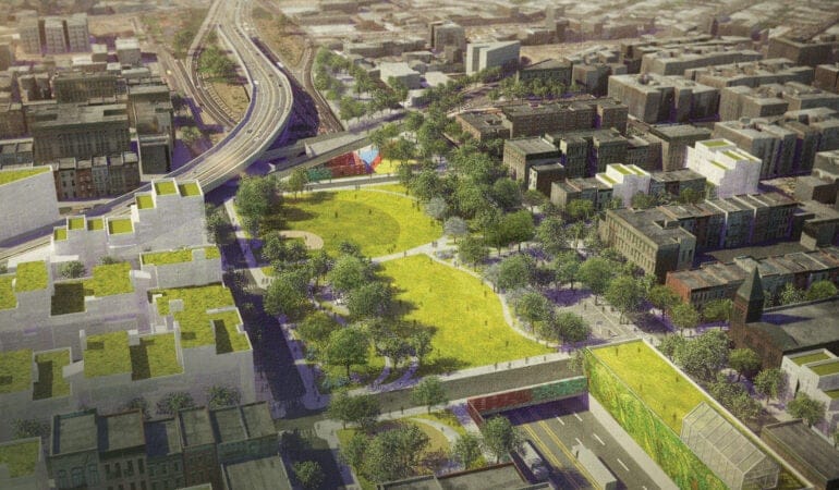
BQGreen
Highway infrastructure systems across the United States are designed for one primary purpose: to move people and goods quickly from one place to another. But, as a society, it is time to rethink this singular, limited view and consider how infrastructure systems can also become productive corridors of beauty, culture, ecology, and recreation. The BQGreen project considers one such corridor—the Brooklyn-Queens Expressway (BQE)—and examines in depth two sites along its 11.7-mile (18.829-kilometer) length.
The BQE was originally proposed by the Regional Plan Association during the mid-1930s to relieve traffic congestion, facilitate industrial development, and strengthen the connection between the boroughs of New York City. The BQE differed from the city’s other parkways by accommodating both commercial and noncommercial traffic. City planner Robert Moses (1888–1981), as the chairman of the Triborough Bridge and Tunnel Authority, charted its path from the Brooklyn Battery Tunnel near Red Hook to Grand Central Parkway in Queens. Construction of the BQE left a trail of divided neighborhoods in its wake.
We know from examples such as Riverside Park (1875 and 1937) in Manhattan, a hybrid Olmsted- and Moses-era park constructed on a concrete box over a major rail corridor, that it is possible to layer transportation with extraordinary public parks. Density is an urban concept that is tied to economics. As the land that infrastructure systems occupy becomes more valuable, it makes sense to layer. As environmental impacts and benefits begin to be assessed in economic terms, the value of making significant alterations to our roadways becomes more attractive at a time when America’s highway infrastructure is near the end of its lifespan and in need of significant repair. As these old systems are replaced, why not reexamine them and consider how they might serve economic, ecological, recreational, public health, and pedestrian-friendly circulation needs in addition to transportation?
Since 2005, DLANDstudio has examined two sunken sections of the BQE. The project began on a theoretical level with a grant from the New York State Council on the Arts to look at tiny Cobble Hill and Carroll Gardens before expanding to study a very different neighborhood in SouthSide Williamsburg, with funding from then City Councilwoman Diana Reyna. The latter study went into great detail about the economic, social, and public health consequences of adding a park to the impoverished neighborhood. Extensive community outreach included visits to neighboring playgrounds, church events, and performances to make sure we recognized the voice of the community. Data were developed regarding the financial feasibility of capping costs—including ventilation and structural costs—as well as analysis of job creation, real estate value, and even the bump in retail sales at neighboring bodegas. We studied public health issues and discovered very high asthma and obesity rates as well as a relative dearth of open recreational space for kids in the vulnerable preadolescent stage. We discovered gang territories defined by the trench and imagined blurring the boundaries with new soccer and baseball fields. We helped the community to dream and then engaged the agencies to help fulfill that vision, with formal support for the proposal from New York City’s Departments of Transportation, Environmental Protection, and Parks and Recreation. Outreach to Congressional Representative Nydia Velázquez and U.S. Senator Kirsten Gillibrand also yielded positive support. To realize this vision will take the collaboration of city, state, and federal agencies; through the master plan we are making a strong argument for why this is the right project for all to support, as we work to make our communities and cities more efficient, livable, and environmentally productive.
The insertion of quality open space has the capacity not only to improve the aesthetics of neighborhoods, but also to serve as a catalyst for ecological and economic improvements to the urban environment. This project establishes a vision of the BQE as a place of opportunity where new open space can be created by introducing an environmental and recreational corridor and turning a former eyesore into a public amenity.
QueensWay
Already, 20,000 miles (32,187 kilometers) of abandoned rail corridors have been turned into bicycle and pedestrian greenways across the United States.22 The QueensWay Vision Plan, commissioned by the Trust for Public Land (TPL), a nonprofit organization founded in 1972, is one of TPL’s several current national initiatives to transform former rights-of-way in cities into active and engaging community greenways. The project involves the conversion of a former Long Island Rail Road line into a new open-space corridor for the public.
The history of land development in Queens is largely defined by the numerous rail lines that subdivided open tracts of land during the late nineteenth and early twentieth centuries. The QueensWay appropriates one of these infrastructural lineaments to opposite effect, as a unifying device. Each of the three main segments of the QueensWay—northern, central, and southern—possesses a distinct physical character that creates unique staging opportunities for the interaction of urban and natural space. Along its 3.5-mile (5.633-kilometer) length, the former right-of-way transforms from an elevated embankment to a ravine to an elevated steel viaduct. The adjacencies along the QueensWay also vary, with Little League baseball fields along the northernmost end; big-box-store parking lots, residential neighborhoods, and a public park in the middle; and crossing train lines, commercial corridors, and parking lots to the south. Issues such as safety, security, and the privacy of adjacent properties are directly tied to how the former railway line moves through the urban landscape. A quiet presence in the city, camouflaged by school-bus parking, overgrown vines, light industry, and limited access, the QueensWay has the potential to be a beautiful recreational and ecological amenity for the community.
The Future
John Wesley Powell (1834–1902)—among America’s greatest geologists, scientific surveyors, and explorers—in his famous 1878 “Report on the Lands of the Arid Region of the United States,” called for a clearer understanding of the climate and carrying capacity of the American Southwest, recognizing that not all landscapes and their capacities for human development are the same:
To a great extent, the redemption of all these lands will require extensive and comprehensive plans, for the execution of which aggregated capital or cooperative labor will be necessary. . . . It was my purpose not only to consider the character of the lands themselves, but also the engineering problems involved in their redemption, and further to make suggestions for the legislative action necessary to inaugurate the enterprises by which these lands may eventually be rescued from their present worthless state.24
Powell wrote at a time when massive changes and their resultant impacts upon the American landscape were only beginning to be understood. We are at a similar stage in history when global climate change and an overall recognition of the impacts of people on the natural environment are yielding potentially catastrophic consequences. Powell, Gilbert White, and Jürgen Habermas, writing in different eras, all called for the integration of disciplinary and social thinking about our interaction with the physical world, beginning with the inherent, natural capacities of an environment to perform. Though they approached issues from different perspectives, they also understood a need for a multivalent, interdisciplinary approach to our occupation of the planet that involves ecological, economic, sociological, and artistic metrics.
The unprecedented and unrepeated investment in the American landscape during the New Deal and post–World War II periods provides replicable models from which to develop new systems of infrastructure that will help ameliorate the impacts of urbanization and climate change. New technologies and approaches to infrastructure that value working with natural systems can help create systems that grow stronger and more resilient over time. Collective will, new financing models—public or private—and strong leadership are needed to make WPA 2.0 a natural infrastructure system that can reduce human impact on the global biota.
Susannah Drake is the founding principal of DLANDstudio Architecture and Landscape Architecture, whose “Rising Currents New Urban Ground” proposal is in the permanent collection of the Museum of Modern Art and Cooper-Hewitt Design Museum. Since 2005, she has taught at Harvard, IIT, FIU, CCNY, Syracuse, Washington University in St. Louis, and The Cooper Union. Her work and writings have appeared in National Geographic and The New York Times, and she has contributed to Infrastructural Urbanism (DOM Publishers, 2011), Under the Elevated (Design Trust for Public Space, 2015), DEMO:POLIS (Akademie der Künste, 2016), and Nature and Cities: The Ecological Imperative in Urban Design and Planning (Lincoln Institute of Land Policy, 2016).
Drawing courtesy of DLANDstudio Architecture + Landscape Architecture, PLLC.
1. The WPA and the PWA were both New Deal programs during the Great Depression. Despite their similar-sounding names, they have critical distinctions: First, WPA laborers were hired directly by the government, while the PWA contracted much of their work to private entities. Second, the WPA engaged primarily in smaller projects with local governments such as schools, roads, sidewalks, and sewers, while PWA programs included large-scale bridges, tunnels, and dams. See: Leighninger, Robert D. “Cultural Infrastructure: The Legacy of New Deal Public Space.” Journal of Architectural Education, Volume 49, No. 4 (May, 1996): 226–236.
2. Carstensen, Vernon, “Patterns on the American Land,” Publius: The Journal of Federalism, Vol. 18, No. 4 (Fall 1988): 31–39.
3. Stilgoe, John R., Common Landscape of America, 1580 to 1845 (New Haven, CT: Yale University Press, 1983), 104.
4. The origins of this famous phrase about Manifest Destiny in America are disputed. Fred R. Shapiro, the editor of the Yale Book of Quotations, comments on the origins in the Yale Alumni Magazine (September/October 2008); see http://www.archives.yaleulumnimagazine.com.
5. See, for example, de Crèvecoeur, J. Hector St. John, Letters from an American Farmer (London, UK: T. Davies, 1782).
6. See Hudson, John C., Plains Country Towns (Minneapolis: University of Minnesota Press, 1985), which won the first John Brinckerhoff Jackson Book Prize of the Association of American Geographers.
7. Merchant, Carolyn, The Columbia Guide to American Environmental History (New York, NY: Columbia University Press, 2002), 112.
8. Habermas, Jürgen, “The Uncoupling of System and Lifeworld,” in Elliott, Anthony, ed., The Blackwell Reader in Contemporary Social Theory (Oxford, UK: Wiley-Blackwell, 1999), 175.
9. Gilligan, Carol, In a Different Voice: Psychological Theory and Women’s Development (Cambridge, MA: Harvard University Press, 1982).
10. Oberstar, James L., special comments in LePatner, Barry B., Too Big to Fall: America’s Failing Infrastructure and the Way Forward (Lebanon, NH: Foster Publishing, in association with the University Press of New England, 2010), xi.
11. Tracy, Tammy, and Hugh Morris, Rail-Trails and Safe Communities: The Experience on 372 Trails (Washington, D.C.: Rails-to-Trails Conservancy, 1998); available online at http://www.railstotrails.org/resources/documents/resource_docs/Safe%20Communities_F_lr.pdf.
12. See http://www.infrastructurereportcard.org.
13. See, for example, Kolbert, Elizabeth, “The Siege of Miami,” The New Yorker (December 21 and 28, 2015): 42–46 and 49–50.
14. White, Gilbert F., “The Changing Role of Water in Arid Lands,” in Kates, Robert W., and Ian Burton, eds., Geography, Resources, and Environment: Vol. 1, Selected Writings of Gilbert F. White (Chicago, IL: University of Chicago Press, 1986), 137.
15. Ibid.
16. As defined by the EPA, “gray” infrastructure is “conventional piped drainage and water treatment systems” and “green” infrastructure is “designed to move urban stormwater away from the built environment [and] reduces and treats stormwater at its source while delivering environmental, social, and economic benefits.” See EPA, “What is Green Infrastructure”; available at https://www.epa.gov/green-infrastructure/what-green-infrastructure.
17. See, for example, Ganis, John, with essays by Liz Wells and James E. Hansen, America’s Endangered Coasts: Photographs from Texas to Maine (Staunton, VA: George F. Thompson Publishing, 2016).
18. See http://www3.epa.gov for an update.
19. See Alexiou, Joseph, Gowanus: Brooklyn’s Curious Canal (New York, NY: NYU Press, 2015).
20. For an overview of Sponge Park, see Foderaro, Lisa W., “Building a Park in Brooklyn to Sop Up Polluted Waters: Site Will Treat Thousands of Gallons near Canal,” The New York Times (December 16, 2015): A27 and A29.
21. See, for example, Palazzo, Danilo, and Frederick R. Steiner, Urban Ecological Design: A Process for Regenerative Place (Washington, D.C.: Island Press, 2011), 6; and “Rising Currents: Projects for New York’s Waterfront to Respond to Climate Change,” Landscape Architecture China, Vol. 11, No. 3 (June 2010): 70–75.
22. The origins of the rails-to-trails movement was brilliantly presented by Charles E. Little in his now-classic book, Greenways for America (Baltimore, MD: The Johns Hopkins University Press, in association with the Center for American Places, 1990).
23. Carbonell, Armando, Mark Pisano, and Robert Yaro. 2005. Global gateway regions. September. New York, NY: Regional Plan Association. http://www.america2050.org/pdf/globalgatewayregions.pdf.
24. Powell, J. W., “Report on the Lands of the Arid Regions of the United States, with a More Detailed Account of the Lands of Utah” (Washington, D.C.: Government Printing Office, April 2, 1878), viii.