
After a year of intensifying drought, fires, and floods, leaders of the conservation movement are tapping into widespread concern about climate change by emphasizing that forests, grasslands, parks, and peat bogs play a critical role in both soaking up carbon and building resilience.
Last fall, scientists at The Nature Conservancy (TNC) released a list of forests from Washington to Georgia that, if properly protected, could help remove millions of metric tons of carbon dioxide from the air each year. Around the same time, a coalition of conservation groups and sustainable business organizations called US Nature4Climate launched a campaign under the banner, “Conservation IS Climate Action.” A few days after that, Cities4Forests, a group of 73 cities committed to forest conservation and restoration, issued a call to action urging urban leaders to embrace nature-based climate solutions.
With the existential threat of climate change vaulting to the top of the hierarchy of global problems, conservationists are increasingly emphasizing the critical role of land, from rural forests to working landscapes to urban street trees, in confronting that challenge. Significant ongoing work to protect land and preserve biodiversity falls under the rubric of natural climate solutions, defined by TNC as “conservation, restoration, and improved land management actions that increase carbon storage or avoid greenhouse gas emissions in landscapes and wetlands across the globe.”
“There’s nothing better for keeping carbon in the ground and extracting more carbon out of the air than simply protecting forests,” said Mark Anderson, director of TNC’s Center for Resilient Conservation Science, which recently added carbon storage to the searchable criteria in its popular online Resilient Land Mapping Tool. “Our most important partner is the living land.”
Land conservation can have multiple benefits of critical value in this era, said Jim Levitt, director of the International Land Conservation Network (ILCN). In addition to carbon sequestration, “conserved coastlines can buffer us from sea-level rise. Vibrant tree growth in cities can mitigate heat-island effects. Farms with vegetative buffers can substantially reduce water pollution. Protected highlands can provide clean water to dense urban centers,” said Levitt, who coauthored a forthcoming Policy Focus Report about civic conservation groups providing climate solutions. “The list goes on.”
Conservation got special attention at the COP26 climate summit in Glasgow in November, when leaders of more than 140 nations pledged to end deforestation and land degradation by 2030, expanding a commitment made by 39 nations in 2014. The Glasgow pledge followed a commitment by 50 countries to protect 30 percent of the world’s lands and oceans by 2030. The Biden administration’s commitment to the 30×30 campaign, America the Beautiful, will strive to protect over 720 million acres during the coming decade, in part to address “the need to fight climate change with the natural solutions that our forests, agricultural lands, and the ocean provide.”
Land is not a panacea for climate change, which is a crisis that will need to be actively addressed by many sectors. But the climate advantages of preserving land are “irrefutable,” says Anderson, who is the Lincoln Institute’s current Kingsbury Browne fellow. It’s a connection that also has emotional resonance: a recent newsletter from the Land Trust Alliance (LTA), which represents more than 1,000 land trusts and affiliates across the country, suggested land was “the answer to climate despair.”
For Fernando Lloveras San Miguel, executive director of the Conservation Trust of Puerto Rico and a former Kingsbury Browne fellow, this moment for land conservation represents a kind of coming full circle. “Climate change is the result of a lack of land conservation,” he said, pinning the global crisis on rapacious consumption and unsustainable land development practices that have ignored the functionality of ecosystems. His message: “Don’t destroy the basic systems that support life.”
Those systems are particularly well-suited to help in the fight against climate change. Recent studies suggest that forest, grassland, and peatland ecosystems may be even more exceptional at soaking up and storing carbon than previously understood—both aboveground and underground. They can create microclimates that fend off warming temperature trends and even adapt to serve the needs of animals, modifying habitats as wildlife species, by necessity, revise their own specifications for survival to make it through all the climate upheaval. In a warming world where terrifying feedback loops are becoming commonplace, the healthy ecosystem—carefully protected and sustainably managed—promotes a virtuous cycle of biodiversity, a kind of continually improving and more efficient functionality.
The obvious benefits of protecting land stand in sharp contrast to what has been happening, literally, on the ground. Deforestation continues apace as land is cleared for development or agriculture, or ravaged by wildfire, drought, and mudslide-inducing floods. That destruction leads to negative outcomes, simultaneously eliminating vast carbon sinks and spewing new emissions into the atmosphere. Fires release embodied carbon in vegetation and soil, and then emissions intensive development and agriculture—including methane from cows on any land cleared for grazing—is ushered in. So it was that in 2021, the Amazon rainforest started emitting more CO2 than it absorbs.
Similar patterns are emerging around the globe, including in the northeastern United States. Clark University researchers found that the six New England states and New York are collectively releasing an estimated 4.9 million metric tons of carbon dioxide equivalent into the atmosphere each year through forest loss. The loss of carbon storage power means the region is missing out on 1.2 million metric tons of CO2 equivalent (CO2e) in carbon sequestration each year.
“Deforestation is a direct source of carbon emissions, releasing the carbon stored in trees and roots into the atmosphere as carbon dioxide. It also negates one of the best tools we have for drawing carbon dioxide back out of the atmosphere,” wrote the Clark research team. “Thus, slowing the pace of forest loss is an important instrument in the fight against climate change.”
The climate mitigating power of land is so great, economists and others argue that the value of natural ecosystems should be integrated into the global economy—to put a price tag on the climate benefits of land. This perspective was spelled out most recently in the Independent Review on the Economics of Biodiversity led by Sir Partha Dasgupta, professor of economics at Cambridge and fellow of St John’s College.
In the report, which some characterized as the land-oriented equivalent of Sir Nicholas Stern’s watershed 2006 report about the high costs of inaction on climate, Dasgupta identifies nature as “our most precious asset,” one that humanity has badly mismanaged. “My overarching aim is the reconstruction of economics to include nature as an ingredient,” he said.
Land’s role in the climate crisis does have its limits, some say. “There aren’t enough trees in the world to offset society’s carbon emissions, and there never will be,” writes Bonnie Waring, an ecologist at Imperial College London. “If we absolutely maximized the amount of vegetation all land on Earth could hold, we’d sequester enough carbon to offset about ten years of greenhouse gas emissions at current rates. After that, there could be no further increase in carbon capture.”
Planting and protecting trees is valuable, climate activists say, but shouldn’t distract from other major steps necessary to meaningful climate progress: reducing emissions in the transportation, building, and energy sectors; and decarbonizing the economy by ending government fossil-fuel subsidies and support from private financial institutions.
As the climate crisis gains speed, conservationists must also contend with emerging issues. Investors and real estate speculators are making huge acquisitions of land on higher ground that will be more productive given warmer temperatures and new rainfall patterns. And a debate has erupted over land-based carbon offsets, which allow polluters to counter their emissions by paying for greenhouse gases to be removed from the atmosphere somewhere else. Critics say the credits let polluters off the hook, allowing them to continue to emit greenhouse gases while they support sequestration functions that would be happening in protected areas either way. It should not surprise that land’s role in climate change would be as complex as the problem itself.
Land Conservation and the Lincoln Institute
Conservation became part of the Lincoln Institute’s portfolio through research on the taxation and assessment of land. In 1976, federal law began allowing tax deductions for gifts of conservation easements—donations of development rights on property that remained in private ownership. But the legislation that recognized this new instrument did not address the property tax consequences of easements, and assessors were unsure about how to value property that had a new legal status but unchanged physical characteristics. The Lincoln Institute, responding to requests for help from environmental groups and assessors, developed courses on this interplay of easements and the property tax.
During the 1980s, the organization’s interest in land stewardship grew, with staff and study groups dedicated to the topic. In 1981, a Boston attorney on sabbatical to study voluntary conservation, Kingsbury Browne, organized a national convening at the Lincoln Institute’s headquarters. The participants, affiliated with some 40 land trusts and related groups from Maine to California, resolved to form a national Land Trust Exchange, which became the Land Trust Alliance (LTA). Now a significant catalyst for conservation, LTA has 1,000-plus member organizations and affiliates that have protected 61 million acres nationwide. Browne’s legacy lives on eponymously in an annual award from LTA and a Lincoln Institute fellowship.
Today, the Lincoln Institute has identified “sustainably managed land and water resources” as one of its six primary goals. The International Land Conservation Network, launched in 2014, builds capacity for conservation around the world; the Babbitt Center for Land and Water Policy, launched in 2017, promotes the integration of land and water planning, primarily in the U.S. West.
“You can’t mitigate climate change without the land sector,” says Andrew Bowman, president of the LTA. Bowman said most of the group’s members are considering climate change prominently in their stewardship practices, land management, and restoration activities. But it’s not the only thing shaping today’s conservation actions: “We have interconnected crises of climate, biodiversity, and equity.”
Add public health to that mix. The pandemic underscored the need to better understand biodiversity, habitat loss, and the interaction of humans and wildlife. “Restoring and protecting nature,” observed a National Science Foundation research announcement, “is essential to preventing future pandemics.”
It could also be essential to surviving them. “Land conservation and restoration is critical to addressing the climate crisis, but is also central to the health of our communities—along that whole spectrum from urban parks to remote wildlands,” said Jamie Williams, president of The Wilderness Society and the 2009 Kingsbury Browne fellow. “The pandemic has shown just how central time in nature is to our resiliency, emotional, physical, and mental health. Studies bear that out, so a big focus of ours has been on creating greater park equity in urban areas and securing equitable access to the outdoors.”
Equity is a critical part of the current conservation-climate conversation. By drawing attention to their role in the coalescing worldwide campaign to address climate change, conservation leaders can create a bigger tent, diversifying their ranks and reaching people who might not otherwise make the link between climate and land. An increasingly intentional focus on climate equity, borne out in campaigns for equitable access to urban parks, partnerships with sovereign tribal nations, and the like, has the potential to further expand the movement’s reach and impact.
Climate and Conservation Facts
Total tons of carbon dioxide emitted by humans each year: 11 billion
Amount from burning fossil fuels: 9.5 billion
Amount from deforestation: 1.5 billion
Percent of human-produced carbon dioxide absorbed by land and water: 50
Percent by which human-produced carbon dioxide has increased since 1750: 50
Metric tons of carbon dioxide a typical 1,000-acre forest in the eastern United States can soak up each year: 180
Acres of land protected by civic conservation in the United States: 61 million
Percent of oceans legally protected, globally: 7
Percent of land legally protected, globally: 15
Percent of land and oceans the world is working to protect by 2030: 30
Sources: Climate.gov, The Nature Conservancy, Land Trust Alliance, International Union for Conservation of Nature.
Indigenous communities, in particular, are at the ready with creative, nature-based solutions. Some 50 tribes in the United States have developed far-reaching, nature-based climate action plans on indigenous lands across the country, including activities from coastal restoration to prescribed burns. Tribes are “using traditional knowledge, but taking advantage of the science and the data,” said Nikki Cooley, co-manager of the Tribes and Climate Change Program for the Institute for Tribal Environmental Professionals in Flagstaff, Arizona. The approach reflects the cultural perspective of indigenous nations, she said, “that they have a responsibility to the Earth, a relationship with the Earth . . . connecting people to the land.”
In Gowanus, Brooklyn, urban landscape architects find themselves in common cause with traditional conservation organizations as they work together to protect biodiversity and build climate resilience in densely developed urban corridors. “Networks of green infrastructure in cities create a refuge for wildlife,” said Susannah Drake, adjunct professor at The Cooper Union for the Advancement of Science and Art. “Dark skies, greenbelts, and adapted right of way corridors link [rural areas] with urban centers.”
The linkages, she said, “revive the large landscape productivity of regions . . . . If we can’t take all the land back [for conservation], we know enough about landscape ecology to make the urban-suburban-rural transect embody greater biodiversity.”
On an even broader scale, the Biden administration’s America the Beautiful program “presents an enormous opportunity to bring the climate and conservation agendas into better alignment, if not explicitly link them,” said Sacha Spector, program director for the Environment at the Doris Duke Charitable Foundation, who noted the existence of a longstanding division between conservation and climate funders, even within the same foundations. “That means engaging all sorts of potential stakeholders and funders in this more holistic understanding of land conservation and stewardship, from urban reforestation and greenspace advocates to the big climate funders, to health and resilience interests. For both biodiversity and climate, this is an all-hands-on-deck moment.”
In 2019, as part of an effort to bolster support for the 30×30 campaign, the Center for American Progress issued a report on the state of America’s natural areas. The report suggested that the question of how much nature to keep—in an effort to “curb wildlife extinctions, fight climate change, reduce toxic pollution, and safeguard healthy natural systems upon which future generations will depend”—should be the subject of an urgent national conversation.
“There can be no single or simple answer to a question that is simultaneously moral, economic, religious, historical, cultural, scientific, and, for many people, deeply personal,” says the report. “A discussion of how much nature to protect—and how, where, and for whom—must honor and account for the perspectives of all people, including communities that are disproportionately affected by the degradation of natural systems; communities that do not have equal access to the outdoors; tribal nations whose sovereign rights over lands, waters, and wildlife should be finally and fully upheld; communities of color; and others.” It’s been only two years since the report was issued, but that discussion has taken on even greater urgency in the face of the global pandemic, widespread calls for addressing racial injustice, and the increasingly visible effects of climate change.
Ultimately, climate and biodiversity are “braided together,” says Levitt. Addressing climate change in a meaningful way requires understanding those connections—and understanding our own role in the nature of things.
“Forests are . . . the unknowably complex green webs that bind together the fates of millions of known species, with millions more still waiting to be discovered,” writes Waring, the ecology professor at Imperial College. “To survive and thrive in a future of dramatic global change, we will have to respect that tangled web and our place in it.”
Anthony Flint is a senior fellow at the Lincoln Institute, host of the Land Matters podcast, and a contributing editor to Land Lines.
Image: Indonesia peatland. Credit: Rifky/CIFOR via Flickr.

These days, we tend to expect technology to deliver ever more sophisticated data, in ever greater quantities. That’s just as true for users of everyday tech tools as it is for high-level decision makers relying on the most cutting-edge and complex tools to grapple with knotty challenges like conservation and climate change. But sometimes the more important priority is to make the best use of the data and technology that already exist.
That spirit has helped guide some of the early work of the Center for Geospatial Solutions (CGS), launched by the Lincoln Institute in 2020. A nonprofit, mission-driven entity focused on marshalling data and mapping tools to support land use decisions, CGS works with a range of global partners large and small, both on deploying new technology and on helping organizations navigate the tools and information they already have.
Think of it as a hub of data, expertise, and service: “There’s a ton of data,” as well as platforms and tools, says Anne Scott, executive director of CGS. “If you’re there on the ground, trying to do something for your community, it can be overwhelming. We are here to help with that.”
One of the more ambitious early enterprises for CGS has been a collaboration with the Nature Conservancy of Canada (NCC), a private nonprofit focused on conservation. NCC is a large, fast-growing organization with a long track record. Today it protects land equivalent to the size of Florida, spread across multiple provinces. Its interest in sorting out a multiyear strategy to make the most of the mapping and other technologies it was already using led it to seek out the help of CGS. The resulting work in progress is an instructive example of how CGS can play a vital role in helping inform and shape both immediate-term and long-term strategy.
Clearly NCC was already deploying plenty of advanced geospatial tools, but, as its chief conservation officer Marie-Michèle Rousseau-Clair notes, NCC is a land trust, not a tech organization: “Our business is to do conservation.” With that guiding principle in mind, CGS conducted a deep organizational-tech dive, collecting information from around 125 NCC staffers across its Canada-wide outposts.
“We were looking for opportunities, gaps, and pinch points,” says Jeff Allenby, director of geospatial technology for CGS. Allenby noted that this initial analysis was intended to seek ways for NCC to save time and streamline work by, for example, making consistent the way field data are collected and shared across regional offices. Or if, say, certain staff members are emailing several colleagues a day to collect particular nuggets of information, maybe there is a way that process can be automated. CGS has now made a set of recommendations to implement over 18 months, designed to improve NCC’s tech and data processes.
The beginning of the relationship between NCC and CGS happened to intersect with the onset of the pandemic, when regulations restricted NCC field workers from gathering data in person. “There was an extra sense of urgency to leverage technology,” Rousseau-Clair says, and to “achieve the same kind of work with new methods.” CGS helped with creative new thinking and connections with private firms that collect satellite data that might function as a stand-in for field data collection in the short term, and perhaps a useful supplement in the longer term.
As a result of that input, NCC has set up a tech committee to provide considered oversight to the organization’s tech efforts—to make sure everyone understands how Initiative A affects Department B. That may not be the sexiest tech story, Rousseau-Clair says with a laugh, but it lays an important foundation that actually encourages innovation in the long run. “The desire for individuals to innovate is sometimes faster than the organization can change,” she says, but the CGS roadmap aims to accommodate that reality.
CGS also helps partners work directly with cutting-edge technologies for building better and more data-rich maps. It is helping one client experiment with the use of drones to supplement traditional on-the-ground fieldwork to build more comprehensive maps of invasive species (for instance, tracking kudzu’s spread as it chokes out other plants). This data can be combined with surface and elevation information—including information gathered via satellite, as well as by drones and by people on the ground—into dynamic map products.
That said, Allenby notes that while the CGS mission certainly entails keeping tabs on the cutting edge, a key goal always involves sorting out which tech tools are really helpful, and which are just flashy. That’s true whether an organization is large or small. “Just because a tool is there doesn’t mean that you should use it,” he says.
The same spirit animates the newest addition to CGS, the Internet of Water project. Spearheaded by Peter Colohan, the initiative grew out of research suggesting the need for comprehensive and widely accessible water data, analogous to the kind of mapped data associated with land use. “Let’s say you’re a decision maker in a city, like an urban planner,” Colohan says, “and you want to understand the conditions of a local reservoir and a local river over time—supply conditions, quality conditions, as they relate to runoff or particular pollutants.” In Washington, DC, as an example, you’d have to pore over something like 45 data sets to answer your questions. Thus you end up hiring a consultant to gather and organize the data, and if you want to revisit it in a year, you’ll have to do that again. “All of this data should be more readily discoverable,” Colohan concludes. “The future of water management and the future of land management are intimately connected.”
What the Internet of Water initiative recognizes is that there is plenty of water data out there, it’s just not easily accessed, falling under a mix of federal, city, county, state, and private jurisdictions. The idea is to build what amounts to a data network where anyone can “publish” water data with a common set of protocols, making that information available to all. That makes things easier for the hypothetical big-city planner who can hire a consultant, because the consultant can go straight to interpreting and strategizing around the data tranches rather than gathering information, and it also opens up that data to smaller entities that never would have considered trying to access it in the past.
For the last few years, the Internet of Water project has been incubated at Duke University. The move to CGS coincides with what Colohan calls its growth phase, which entails expanding over the next five years but also, crucially, doing so in a way that’s sustainable over time. “The internet is littered with unused tools that have no sustainability model,” he says.
As with much of the early work CGS has done with NCC and other partners, taking this longer view is precisely the key. In a way, CGS is like a consultant, keeping an eye on the latest developments across the field. “Being in the flow seat,” Allenby says. “Trying to position ourselves to know what people are doing, and how it can be applied elsewhere—and making those connections, putting those people together who should be talking to each other.”
At the same time, since CGS is not a traditional consultancy but rather part of a larger organization that is focused on truly moving the needle on land use, climate change, and related challenges, it can take a wider view. “What we’re trying to do,” Allenby says, “is really solve systemic challenges.”
Rob Walker is a journalist covering design, technology, and other subjects. He is the author of The Art of Noticing. His newsletter is at robwalker.substack.com.
Image: This aerial footage from West Virginia was taken by the Center for Geospatial Solutions as part of its work with a large-scale ecosystem restoration partner. Drone footage can complement on-the-ground fieldwork to create more dynamic maps. Credit: CGS.
Having the vision’s no solution, everything depends on execution.
—Stephen Sondheim, 1930–2021
As the world grapples with the ever-worsening consequences of the climate crisis and the terrifying prospects of mass extinction, global political leaders have responded with impressive ambition. At the 26th Conference of the Parties on Climate Change in Glasgow in late 2021, some 153 countries updated their emissions-reduction commitments to help prevent global average temperatures from rising more than 2 degrees Celsius by 2030 and improve the chances of reaching global net-zero emissions by 2050. At the same gathering, 140 countries pledged to end deforestation by 2030.
Meanwhile, at the 15th Conference of the Parties on Biodiversity (COP15), held in Kunming, 70 countries agreed to conserve 30 percent of their lands and oceans by 2030 (30×30), as part of an effort to preserve global ecosystems and prevent biodiversity losses. Many other countries are expected to sign on to the commitment this spring, when COP15 concludes. (COP15 was structured as a two-part event due to the pandemic, illustrating the complexities of reaching any kind of global agreement in the current moment.)
If achieved, 30×30 will contribute greatly to efforts to mitigate the climate crisis, primarily through carbon sequestration. Unfortunately, 2030 isn’t very far off. We’ll need more than good intentions to make progress on this ambitious goal, and land policy will play a central role in the pivot from ambition to implementation.
The Lincoln Institute and its Center for Geospatial Solutions (CGS) have developed a geospatially driven framework for accelerating progress toward the 30×30 goal. Our approach emphasizes the need to think differently about the scope of the problem and its solutions. More specifically, we think stakeholders working on 30×30 need to identify surmountable goals, introduce common accounting of conserved land, integrate environmental and social outcomes, include public and private land in conservation strategies, and build momentum through demonstrated success.

First, we need to set a baseline that accurately assesses the current state of land conservation both nationally and globally. This is more complicated than it might seem. For example, in the United States, where land records are fairly reliable, the USGS Protected Area Database tells us that 13 percent of the country is considered “conserved” explicitly for biodiversity protection. By that metric, we’d need to more than double the amount of conservation we have achieved to date to reach 30×30. If we look only at the continental United States, conserved land drops to about 8 percent, meaning we would need to almost quadruple the amount of land we conserve in the next eight years, an almost insurmountable task.
But changing how land is managed can help meet conservation goals without the need to newly protect an additional 22 percent of the nation’s land (440 million acres). For example, public and tribal ownership accounts for just over 25 percent (500 million acres) of land in the United States. That land is not considered conserved because resource extraction is allowed or there is no explicit mandate to protect biodiversity. In addition, urban and suburban parks, greenways, trails, and other municipal lands that are used for recreation are often not counted as conserved lands. Protected lands in the urban/suburban landscape play a big role in improving people’s health, addressing environmental injustice, and creating corridors and habitat for other species. Changing how land is managed, from prohibiting mining and oil exploration to explicitly protecting biodiversity, can help us gain conserved land to count toward 30×30 without requiring us to start from scratch.
Private land protected by conservation easements will also play a big role in meeting our national land protection goals. Currently the National Conservation Easement Database, the accounting system for privately conserved land, is outdated. We need better incentives for land trusts and private landowners to contribute data on their properties that will build a more comprehensive and accurate national picture of private land conservation. This will also contribute to better management and restoration outcomes.
With a combination of newly conserved land and better management of public lands to meet conservation goals, 33 percent of the continental United States could be conserved very quickly. But without a way to identify the lands that are most critical to support our conservation priorities and a commitment to conserve and count them, progress will be slow.
At the Lincoln Institute, we think a balanced prioritization strategy is needed that looks at a variety of conservation goals—including biodiversity protection, resilient and connected landscapes, and carbon sequestration—and that considers other overriding objectives, such as protecting highly productive farmland or improving access to nature for underserved communities.
We propose a more integrated view and comprehensive approach that looks at the whole country, considers multiple conservation priorities, ensures equitable access to land, and attracts effective conservation financing. Current efforts to map priorities do not account for the social component of conserving, improving, and restoring lands. Decisions about conservation should be based not only on biodiversity and environmental data but also on data about people and their needs, relationships, and interactions with land. By considering such data, we can protect land for multiple benefits to both people and nature. To illustrate the opportunities before us, CGS created an analysis that can guide collective efforts to protect critical landscapes. True to the collaborative spirit that guides the work of CGS, these maps draw upon and synthesize the collective wisdom of leading scientists and organizations focused on this effort, including NatureServe, The Nature Conservancy, and the World Conservation Monitoring Centre.
By assembling complete and accurate data on public and private lands that are or should be protected, and making this data open and freely accessible to all communities, we can achieve conservation that is inclusive and equitable. In addition, we can integrate other data sets as they become available that will allow us to monitor and manage conserved lands and determine whether they are delivering on intended outcomes. Rigorous monitoring is essential; without it, we won’t know whether we’ve reduced runoff and pollutants into streams and rivers, established green sinks to mitigate greenhouse gas emissions, or improved community health—and we won’t be able to track and celebrate progress toward national and global conservation goals.
Finally, to support national and global efforts to achieve 30×30, we need to establish a management infrastructure that ensures transparency and accountability. Regular communication about land protection efforts, whether those efforts are conducted by small land trusts or government agencies, will create a common framework and language so that all stakeholders can see how they fit into the bigger picture and how even small opportunities can play a role in this global effort. Each country will need a secretariat/management and facilitation structure, as well as effective processes for regularly convening, making decisions, and monitoring progress. Successful global efforts ranging from eradicating polio to halving child mortality to post–World War II reconstruction have relied on the global community investing in and standing up an effective management infrastructure. It has been done before, and we can do it again.
The United States and many other countries are prepared to make massive investments in natural and built infrastructure. This unprecedented public spending could either enhance the protection of or threaten land that is conserved, or should be conserved, to mitigate the climate crisis and preserve biodiversity. But we cannot predict the impact these activities will have on land that we don’t recognize. We need to do a better job of land and data management and make this information accessible to all partners to facilitate a larger conversation as soon as possible. And if we are serious about protecting 30 percent of our land and water resources by 2030, we need to move from vision to execution. The Center for Geospatial Solutions at the Lincoln Institute is ready to help.
George W. McCarthy is president and CEO of the Lincoln Institute of Land Policy.

In the wake of major global agreements to protect biodiversity and address climate change, hundreds of leaders and practitioners gathered virtually for one of the world’s most significant international conferences on private and civic land conservation.
At the 3rd Global Congress of the International Land Conservation Network and Eurosite–European Land Conservation Network, leaders in the field discussed how to increase the scale of conservation work to meet ambitious global targets, such as protecting 30 percent of the earth’s land and water by 2030. The conference attracted more than 900 registrants from some 89 countries on six continents.
“Let’s step up to the responsibilities that we have to pass on, to our children’s children’s children and beyond, the beauty and the value of the earth,” International Land Conservation Network Director Jim Levitt said at the closing of the conference.
“The global private and civic land conservation community is diverse and multifaceted,” said Tilmann Disselhoff, president of Eurosite–European Land Conservation Network. “We can learn a lot from our colleagues around the world, but we don’t have to copy everything from one another. When we come across an interesting solution or a new idea from another part of the world, let’s adopt it, if it’s good. But let’s also adapt it to our needs.”
The conference focused on five themes: conservation finance, organization and governance, law and policy, land stewardship, and large landscape conservation. What follows are a few highlights (recordings of all sessions will be available online at no cost in the first quarter of 2022).
Conservation Finance
The scale and complexity of private and civic land conservation projects often requires a mix of financing, from both traditional investors and from those focused on social and environmental impacts. Complex projects need an effective intermediary who can balance the needs of multiple investors and incorporate the perspectives of other stakeholders, experts said in a session titled, “Blended Finance and the Role of Intermediaries.”
Intermediaries play several key roles. They articulate a project’s goals, establish key metrics for success, provide technical support, and communicate between different parties. While individual investors might care mostly about a single outcome such as sequestering carbon, intermediaries can provide a more complete picture of a project’s benefits.
“I’ve never seen a biodiversity or nature project that wasn’t also, on some level, a social project,” said Stephen Hart, a senior loan officer for the European Investment Bank.
Organization and Governance
“There’s no future in conservation unless we’re building meaningful relationships with the original holders of these lands.” That assertion by Nathan Cardinal of the Nature Conservancy of Canada (NCC) was part of a wide-ranging and sometimes deeply personal conversation, “Private Land Conservation and Indigenous Rights: Developing an Ethical Framework and Good Practices.”
Acknowledging that the contemporary conservation movement has benefited from generations of stewardship and land management by Indigenous communities, experts emphasized the urgency of supporting Indigenous rights—a theme that wove through other sessions as well—by taking actions including returning lands to their original owners, ensuring that Indigenous voices are at the table, and providing long-term funding opportunities. “Aboriginal people have managed this land for thousands and thousands of years,” said Cissy Gore-Birch, a Jaru/Kija woman with connection to Balanggarra, Nyikina, and Bunuba country who works as the National Aboriginal Engagement Manager for Bush Heritage Australia. “We are the protectors of the land, and the land speaks to us.”
Law and Policy
As global leaders set ambitious conservation goals, questions about how to reach that target are naturally arising. One answer might well be found in Other Effective Area-Based Conservation Measures, known as OECMs. The concept behind this emerging approach is to complement and connect traditional protected areas by identifying areas where conservation already occurs, though the land is primarily managed for other purposes.
Examples include school campuses, military grounds, cultural sites, and ranchlands. In “The Role of OECMs in an Integrated Conservation Landscape,” panelists agreed that OECMs hold great promise, but that their effective implementation will require more resources, conversation, and collaboration. “As a community of practice, sharing our experiences is going to be important,” said Lisa McLaughlin, vice president of conservation policy from Nature Conservancy of Canada. “. . . We need to keep that going with respect to sharing and learning—the good things, but also talking honestly about the mistakes and the barriers as well, so that we can all accelerate together and not have to learn in parallel.”
Land Stewardship and Management
Clare Cannon’s family manages a 6,500-acre sheep and cattle farm at Woomargama Station in New South Wales, Australia. They use two-thirds of that land to raise their livestock, but a few years ago the family set aside the rest—a mix of native grasslands and woodlands—to be managed by the Biodiversity Conservation Trust. In addition to protecting the land, that decision now seems likely to generate new income in the form of biodiversity payments authorized under Australia’s newly adopted National Stewardship Trading Platform.
Grasslands—known as prairies in North America, pampas in South America, and savannas in Africa—are increasingly being eyed as a climate solution for their ability to sequester carbon. By engaging in sustainable, lower-impact practices, farmers and ranchers from Australia to Colombia, Venezuela, and the United Kingdom can help maintain the integrity of grasslands; reduce the climate impacts of livestock by avoiding or minimizing activities required for conventional agriculture such as deforestation and the cultivation of resource-intensive fodder; and still succeed economically, explained panelists in “Stewarding Grasslands: Good for Grasslands, Good for Climate, Good for Farmers.”
Landscape-Scale Conservation and Restoration
As climate change disrupts natural systems around the world, land conservationists can use technology to target their work to help species adapt to changing conditions and maximize the reduction of greenhouse gases. In “Sustaining Nature Under Climate: New Science to Inform Conservation,” Mark Anderson, Director of Conservation Science for the Eastern U.S. for the Nature Conservancy, demonstrated his organization’s Resilient Land Mapping Tool, which uses geospatial data to identify the areas where conservation resources can achieve the greatest impact.
The tool, which covers the United States but carries the potential for expansion worldwide, analyzes biological, geophysical, and climate-related conditions—everything from sun exposure to soil characteristics—to determine which habitats will enable species to thrive in a warming world, which places currently contain the greatest stocks of stored carbon, and which have the greatest potential for future carbon sequestration.
The Nature Conservancy used the tool to identify what it calls a Resilient and Connected Network, comprising a third of the continental United States, to prioritize for conservation. The network currently stores 29 billion tons of carbon and sequesters an additional 236 million tons of carbon a year.
“That’s the equivalent of taking 188 million cars off the road every year. Why would we want to lose any of this network?” said Anderson, who is also the Lincoln Institute’s 2021–22 Kingsbury Browne Fellow.
Established in 2014, the Lincoln Institute’s International Land Conservation Network helps build capacity for private land conservation through research, training, and exchanges between conservationists from around the world. In February 2022, the Lincoln Institute and ILCN will publish a Policy Focus Report, From the Ground Up: How Land Trusts and Conservancies Are Providing Solutions to Climate Change, which will present case studies of organizations that are using land conservation as a tool for mitigating and adapting to climate change. The next Global Congress will take place in 2024.
Photograph: Marti Garcia via iStock/Getty Images.

As the telltale signs of climate change keep piling up, and severe weather becomes almost a weekly occurrence, major nations are currently unable to work together to bring down emissions and make a collective transition to renewable energy. And that, says climate chronicler Elizabeth Kolbert, is a precarious time for the planet— because some might be tempted to look for questionable alternative solutions.
“We’ve gotten ourselves in a pretty big jam, and to most of these issues, there are no easy answers, there are only a lot of trade-offs,” Kolbert said in an interview for Land Matters, the podcast of the Lincoln Institute of Land Policy. “We are incapable, for all sorts of reasons, of following the social control measures that might rein in a disaster, and then we reach for the techno-fix.”
Noting that “our record in thinking through the consequences is not great,” Kolbert—a staff writer at the New Yorker and author most recently of Under a White Sky: The Nature of the Future—cites one of many examples from her research: the introduction of toads from Central America to control pests in Australia’s sugarcane cropland in the 1930s.
“The toads were not helpful in that way at all, but they were prolific breeders and continue even to this day . . . they’re still continuing to spread around Australia, and they’ve really wreaked ecological havoc. They’re very toxic. The native wildlife in Australia chomps on them and dies,” she said.
“That has led to a new round of thoughts about what they should do to try to control this thing that was brought in as an agent of biocontrol. That’s one pretty classic story of humans doing something, in this case, moving a species around the world with benign intent, but disastrous consequences.”
Despite rhetorical commitments, the planet still does not have an agreed-upon political framework to control the problem of climate change. That opens the door to Hail-Mary geo-engineering solutions such as blasting reflective particles into the atmosphere to dim the sun (the “white sky” of the book’s title). All kinds of collateral damage could occur, Kolbert writes, and failure could unleash blasts of heat, similar to opening an oven door, making conditions worse.
There are some systems that are effective at soaking up carbon, and land is one of them, Kolbert said—although complications and limitations are threaded through even nature-based climate solutions.
“The first step is stop making the hole deeper, to stop deforestation . . . that seems an absolute no-brainer,” she said. “But that being said, it’s extremely difficult. You have a growing global population, a growing global demand. A country like Brazil, a country like Indonesia, their basic way of thinking [is to say], ‘You deforested all of Europe, and deforested all of America, why shouldn’t we?’ That is hard to argue with to a certain extent.”
In addition, letting forests grow to act as carbon sinks is “a slow process. It doesn’t really get us to where we need to go in terms of carbon removal,” she said. Scientists also need to worry about embodied carbon being released back out into the atmosphere, as part of the natural life cycle of trees that die, rot and burn—leading to proposals to bury them in trenches or at the bottom of the ocean.
Kolbert, also author of Field Notes from a Catastrophe: Man, Nature, and Climate Change and The Sixth Extinction, for which she won the Pulitzer Prize, acknowledges the staggering complexity of addressing the climate crisis and that doing nothing is not an option.
But, she adds, “at this point we really seem to lack the tools to make these decisions in the best possible way . . . this partly has to do with international boundaries and very different competing agendas. We don’t have what social science would call the governance tools for a lot of these technologies.”
In the interview, Kolbert also reflects on the challenging business of communicating about climate change, and the prospect of climate fatigue, which causes people to tune out as the stories get more alarming.
Climate change and land’s role in both reducing emissions and adapting to new realities is a big focus for the Lincoln Institute, which is celebrating its 75th anniversary. Climate has been a frequent topic on the Land Matters podcast over the course of the last year, including interviews with Bruce Babbitt, Jim Levitt, and Bill McKibben.
You can listen to the show and subscribe to Land Matters on Apple Podcasts, Google Podcasts, Spotify, Stitcher, or wherever you listen to podcasts.
Further Reading
Electrified Rivers and Other Attempts to Save the Environment
Pathways to Decarbonizing the Planet of Cities
Postcards from a World on Fire
Anthony Flint is a senior fellow at the Lincoln Institute of Land Policy, host of the Land Matters podcast, and a contributing editor of Land Lines.

Claudia López was elected mayor of Bogotá in October 2019, after campaigning as a Green Alliance candidate with a focus on climate change and other environmental issues. She is the city’s first female mayor and first openly gay mayor.
Mayor López was a senator of the Republic of Colombia from 2014 to 2018 and became a prominent figure in the fight against corruption; she was the vice presidential candidate for the Green Alliance party in the 2018 presidential election.
Prior to her political career, López worked as a journalist, researcher, and political analyst. She studied finance, public administration, and political science at the Universidad Externado de Colombia, and went on to earn advanced degrees in the United States: a master’s degree in public administration and urban policy from Columbia University and a Ph.D. in political science from Northwestern University.
López spoke with Senior Fellow Anthony Flint by video as she was on her way to the COP26 climate summit in Glasgow in the fall; they were joined by Martim Smolka, director of the Lincoln Institute’s Program on Latin America and the Caribbean.
Their discussion, edited for length and clarity, is the final installment of a special 75th anniversary Mayor’s Desk series, spotlighting the chief executives of cities that share a history with the Lincoln Institute. It is also available as a Land Matters podcast.
ANTHONY FLINT: Your victory suggests that residents are ready for serious action with regard to the environment and climate change. Do you feel you have a mandate, and what are your top priorities in terms of climate?
CLAUDIA LÓPEZ: Well, there is no doubt that I have a clear mandate from Bogotá’s people. During my campaign, I [made a public commitment] to environment and climate change issues. We have a deep social debt and a deep environmental debt that we have to pay. After the pandemic, the social debt will be harder to address than the environmental debt, because the pandemic has doubled unemployment and poverty in my city. On the other hand, on the environmental issues, I am still very optimistic that post-pandemic opportunities will increase.
We have to adapt, that’s our mandate. In the context of Colombia, we have three general issues. One of them, and the major contributor to climate change, is deforestation. This is an issue mainly for rural Colombia, and is by far the largest contributor of Colombia to the environmental crisis and the climate emergency. The second factor is fossil fuels. Transportation is the second largest contributor of Colombia to the climate emergency. The third is related to waste management. Bogotá has a great impact in transportation, and we have a great impact in waste management.
What are we doing? Migrating from a monodependent diesel bus system toward a multimodal system based on a metro, a regional train system, cable system, and also buses . . . [and] transforming waste management . . . into a recycling, green, circular economy, so that we transform waste into clean energy. Making the city greener. Hardening rural and green areas, that’s basically what building cities is about. What we need to do in the 21st century, I think, is the opposite. We need to take advantage of every public space that we have, making every effort not only to plant trees, not only to plant gardens, but to transform urban areas that we had before, gray areas that we had before, into green areas.
We’re lucky that we have the legal mandate to propose a new master plan, the POT [Plan de Ordenamiento Territorial]. We can include these changes and investments, not in a four-year-term government plan, but in a 14-year city plan. We are trying to take advantage of this moment.
AF: This year marks the centenary of the Colombian value capture tool contribución de valorización, or betterment contributions. What is your vision for building on that tradition?
CL: I think that’s critical. The most important financial tool we have for sustainable development is land value capture. In our POT, we are including not only the traditional betterment contribution, but also many other ways to use land value capture. [Ed. note: Betterment contributions are fees paid by property owners or developers to defray the cost of public improvements or services from which they benefit.]
We have at least seven different tools, financial tools, all related. Basically, we [determine] the value that’s going to be generated by a transformation of land use and we agree with the developer, so that the developers don’t pay us in cash, as in the betterment contribution, but pay [by] building the infrastructure and the urban and social equipment that new development will need.
This is not about having lovely maps with marvelous plans, this is about having the money to redistribute the cost and benefit of sharing and receiving. This is actually what I think urban planning is: making sure that either through public investments or through land value capture or through private investments, we ensure an equitable and sustainable share of the cost and benefits of building the city. That’s the role of the government, and that’s what we’re trying to achieve here.
AF: I’d like to turn now to the topic of crime, and ask you how has the problem of crime had an effect on the perception of the city and public space in the city in particular?
CL: It has a huge impact, of course. The more crime you have in public spaces, as a fact or as a perception, the less well-being you have as a city. What makes a city safer? The first thing I think is to make the city sustainable, and that means greener, and that means more equitable.
My top priority to make Bogotá safer is not to add cameras and technologies. It is to make sure that Bogotá has the capacity to provide fair and legal employment for our population, particularly for our youth. I think that the social roots of security are more important.
One thing that I’m very excited and very proud that we’re building into our POT and our land use development plan is that we are including criteria for women and caregivers as criteria for urban development in our city. If you can make a city safer for women, if you can make a city safer for kids, that will be a city safer for everyone.
Now the second thing, as important as transportation, infrastructure, and social infrastructure in the 21st century, is digital infrastructure. We are going to extend fibra óptica, the best, fastest internet, to every neighborhood in our city, to every school in our city. That’s crucial to make a more sustainable, more equitable, and safer city. At this moment in the post-pandemic time, we’re having a severe backlash in insecurity in our cities. It’s not only in Bogotá, it’s global. Unfortunately, higher unemployment and higher poverty always correlate with higher insecurity.
AF: What are the policies that are working to make life better in informal settlement, such as upgrading or infrastructure, and what in your view needs to change?
CL: We have at least three innovations included in our land use plan that I’m very proud of. As you know, in Latin America, roughly half of our cities has been built informally. This land use development plan is the first development plan that clearly assumes that, accepts that, and instead of doing a land use plan that is only useful for the formal city, for half of the city, this is a plan that recognizes that 45 percent of our city is informal.
It creates an urban norm, urban rules, and urban institution to help people improve their homes in the informal city, and to improve their neighborhoods. It is including all people within the land use development plan.
We have in Bogotá an institution called curaduría, which provides urban licensing and construction licenses. We are creating a public curaduría for the informal city. There’s no way that you can impose on half of the city an urban [standard] they don’t have any chance to meet. We [also] have the Plan Terrazas, which says, after we improve your first floor, after we improve it properly, then you can build your second floor, for example, or you can build some [space for] economic activity in your first floor. You will improve your housing, but you will [also] improve your income. For poor people, housing is not only the place they live, it’s also the place where they produce and they generate income.
The second thing that I think is very important is that we created this caring system, particularly thinking about women. Half of the economy is informal. It’s not formal jobs with pension funds and health insurance. They don’t have care when you are sick or when you are [older]. Who takes care of the sick and elderly? It’s the unpaid women who do that: 1.2 million women in Bogotá don’t have jobs, don’t have education, don’t have time for themselves because they are caregivers. For the first time in Bogotá, we are reserving land for social infrastructure to provide institutional health care. For children, for women, for elders, for people with disabilities, so that we can relieve and free up time for women, so they can access time to rest. They don’t have a free week ever in their life.
We’re trying to balance. I think the development in Bogotá has been incredibly unbalanced, with [much of] the advantage on the developer side. Of course, the developers need profitability, and we are trying to find the equilibrium point.
AF: The Lincoln Institute’s work in Latin America, including Colombia, has been such a big part of our global reach. As we celebrate our 75th anniversary, could you reflect on how that presence has been helpful in the region?
I think it has been incredibly helpful really. I [have worked] with the United Nations and with other organizations, and different governments in Latin America. There’s always a specialist or academic person or professional person who has been trained by the Lincoln Institute. There’s a huge network of people thinking, researching, innovating, putting out these debates, which is incredibly important.
In my own experience, I cannot tell you how useful all the things that you taught me have been, on land value capture, for example, on land use development, on being aware of how land and urban value is created. Why this is a publicly created thing, and why we need to use all the instruments we have to capture that value and to redistribute it in a more equitable way to everybody in the city. To Martim Smolka, Maria Mercedes, and everybody in the Lincoln Institute, I cannot be more grateful, and the network of professionals and trainees and academic people and the research that they support on this topic, particularly in Latin America, is incredibly useful.
This interview is also available as an episode of the Land Matters podcast.
Anthony Flint is a senior fellow at the Lincoln Institute, host of the Land Matters podcast, and a contributing editor to Land Lines.
Image: Mayor López speaks at a climate event at the COP26 summit in Glasgow. Credit: Office of the Mayor.

Editor’s Note: This article was adapted from “Investing for the Future,” published July 22, 2021.
As governments consider major infrastructure proposals, the Lincoln Institute has published a new book that will help policy makers achieve a greater return on public investments. Edited by José A. Gómez-Ibáñez and Zhi Liu, Infrastructure Economics and Policy: International Perspectives includes contributions from 30 leading international academics and practitioners on topics such as project appraisal, financing, governance, climate change, and technology.
The book comes out at a time when governments of many countries are considering infrastructure as a policy instrument to stimulate national economies that have been adversely affected by the COVID-19 pandemic. The book offers case studies, data, and analyses that can help governments evaluate infrastructure proposals.
It includes the following six takeaways to consider in any infrastructure investment package, based on extensive research into the ingredients for success:
Think Long-Term Growth, Not Quick Stimulus. Contrary to conventional wisdom, infrastructure investment is not an effective way to provide a quick economic stimulus. It takes many years to secure the permissions and funding necessary to begin construction on a new project, and the sophisticated equipment and training required by modern construction means such projects do not offer pathways to quick employment for large numbers of unskilled workers. Infrastructure Economics and Policy explains why infrastructure investments offer few short-term impacts, even when the long-term economic impacts are clearly positive.
Shovel-Worthy Matters, Not Shovel-Ready. The impacts of infrastructure projects depend greatly on their quality. Many infrastructure agencies are required to prepare cost-benefit analyses of the major projects or policies they are considering and of the relevant alternatives to those projects. However, few governments (if any) require the agencies to adopt the alternative with the highest net benefit. This is often because of political considerations, including concerns that cost-benefit analysis might not adequately reflect the goals of fairness and equity. While cost-benefit analyses are not perfect, they are one of the best tools available for evaluating infrastructure proposals, and agencies should be cautious about departing significantly from the option with the highest net benefit without good reason.
Beware of Over-Confidence and Over-Optimism. A landmark analysis of some 2,000 infrastructure projects found that actual costs were significantly higher than forecast, while usage was significantly lower, as Bent Flyvbjerg and Dirk W. Bester explore in a chapter of the book. The authors identify several well-known behavioral limitations that lead to these outcomes, particularly overconfidence bias and optimism bias. Fighting these biases is difficult because they are so deeply ingrained in human nature, but the book describes measures that can help, such as holding forecasters legally accountable or using independent audits.
Take Equity Seriously. The costs and benefits of infrastructure projects are often distributed inequitably. On the one hand, major infrastructure facilities such as highways and power plants are often built in locations where the negative impacts are felt disproportionately by low-income residents and people of color. On the other hand, the lack of access to basic infrastructure, particularly in the developing world, impairs quality of life and contributes to inequality. Governments need to take both problems seriously and enact complementary policies to address them.
Consider Governance Challenges. State and local governments have historically been deeply involved in regulating both private and government-owned infrastructure due to important concerns including access, siting, and protecting against monopolization. However, the advent of a major new infrastructure program—particularly one focused on decarbonizing the energy system to address climate change—will increase the role of the national government. National governments are uniquely positioned to invest in new technologies that require collective action, and to mitigate the economic impact of climate change policies—for example, compensating owners of fossil fuel plants and other assets that lose their value. These and other governance challenges related to infrastructure may prove even more difficult than the financial challenges that current debates focus on.
Invest for the Future and Address Radical Uncertainties. In the face of radical uncertainties including climate change, the pandemic, automation, and the emerging sharing economy, governments must not only fix deteriorating infrastructure, but also invest in a new generation of infrastructure that is climate-resilient and takes advantage of new technologies. This transformation will require overcoming significant institutional barriers, assessing the pros and cons of the new technologies, and putting an effective change management process in place.
Sustainably built infrastructure is indispensable to resilient, equitable, and livable communities and regions worldwide. Through in-depth analysis, Infrastructure Economics and Policy questions the conventional wisdom about several issues, from the most efficient levels of congestion charges on routes into city centers to the belief that privatization greatly affects the performance of infrastructure. With chapters covering land value capture and other funding mechanisms; the role of infrastructure in urban form, economic performance, and quality of life, especially for disinvested communities; and other essential concepts, this new book offers evidence-based solutions and policy considerations for officials in government agencies and private companies that oversee infrastructure services, for students, and for policy-oriented lay readers alike.
To learn more or to order a copy of Infrastructure Economics and Policy, visit https://www.lincolninst.edu/publications/books/infrastructure-economics-policy.
Image Credit: shaunl via Getty Images.
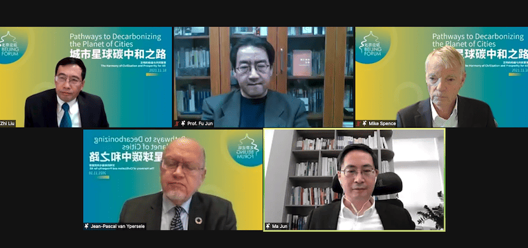
The Peking University–Lincoln Institute Center for Urban Development and Land Policy (PLC) recently co-organized a daylong discussion about climate and energy as part of the Beijing Forum, an annual international academic event co-sponsored by Peking University, the Beijing Municipal Commission of Education, and the Korea Foundation for Advanced Studies.
The “Pathways to Decarbonizing the Planet of Cities” subforum featured scholars and policy makers from China and other countries, including Professor A. Michael Spence of New York University, recipient of the 2001 Nobel Memorial Prize in Economic Sciences, and Dr. Jun Ma, cochair of the G20 Sustainable Finance Working Group. Jointly organized with Peking University’s School of Urban and Environmental Sciences and Energy Research Institute, the conference was livestreamed in both Chinese and English, attracting nearly 8,000 viewers.
Spence delivered a keynote speech on carbon, energy, and urbanization, exploring the relationship between carbon reduction and economic growth and assessing current opportunities in the realms of energy and global collaboration. “While the challenges are enormous, there is an increasing array of low-cost, widely available, powerful tools and technologies available now, and there will be more to come,” he said. “That give us some hope that we can actually achieve” climate objectives.
Spence also analyzed potential challenges related to implementing climate regulations and commitments. At the international level, he used China and India as examples to argue that the appropriate paths and timelines of emissions goals should vary according to the pace of each country’s growth and development. He stressed the importance of transferable, cross-border technologies and finance for global climate success.
“We’ve got huge challenges, we’ve got mechanisms in the form of carbon trading, we’ve got commitment from people, and we’ve got powerful tools,” Spence concluded. “I think the big question mark is the level of international cooperation that’s going to accompany this, and it’s starting to look like it’s moving in the right direction.”
Dr. Zhi Liu, director of the PLC, moderated a roundtable discussion with panelists including climatologist Jean-Pascal van Ypersele, professor of Environmental Science at the University of Leuven, Belgium, and former vice chair of the UN Intergovernmental Panel on Climate Change; Prof. Jun Fu, academic Dean of the Institute of South-South Cooperation and Development of Peking University; Ma, who is also codirector of the Macro and Green Finance Lab of the National School of Development at Peking University; and Spence.
During the discussion, Spence analyzed the effects of past energy policy implementations and proposed that climate change and economic development should be considered as a whole. Ypersele described the positive outcomes of the COP26 meeting in Glasgow, including awareness of the urgent need to take action, the formulation of carbon trading market standards, international compensation mechanisms, and the responsibilities and willingness of developed countries to invest in climate change adaptation. Director Jun Ma discussed the development of green finance on a global scale, pointing out that China’s green investment scope includes decarbonization projects, environmental protection projects, and various biodiversity-related projects. Professor Jun Fu discussed the unique challenges that China faces in decarbonization, including the respective structures of its energy sector, which relies heavily on coal, and its government. The guest speakers agreed that they were cautiously optimistic that the world could meet the goal of limiting the rise in global temperatures to 1.5 degrees. Jun Fu recommended an approach swiftly endorsed by the other panelists: “Hope for the best, prepare for the worst.”
At the conclusion of the subforum, Liu noted that he believed the world is paying more attention to climate change and carbon neutrality, but the road ahead is still difficult. The day’s discussions shed more light on the path toward urban carbon neutrality, he added. “I feel a bit more optimistic and hopeful,” he noted at the end of the roundtable, “and I hope that our audience comes away with a bit more optimism and more hope about our future planet of cities.”
Shenmin Liu is a Research Analyst with the Land and Water Conservation Program and China Program at the Lincoln Institute of Land Policy.
Image: Participants in the Beijing Subforum roundtable included, clockwise from top left, Dr. Zhi Liu, director of the Peking University-Lincoln Institute Center for Urban Development and Land Policy; Professor Jun Fu, dean of the Institute of South-South Cooperation and Development of Peking University; Nobel-winning economist A. Michael Spence of New York University; Professor Jun Ma of Peking University, cochair of the G20 Sustainable Finance Working Group; and climatologist Jean-Pascal van Ypersele of the University of Leuven, Belgium, a former vice chair of the UN Intergovernmental Panel on Climate Change. Credit: PLC.