The world is changing rapidly with digitalization. How can we ensure that our engagement with technology remains equitable and responsive?
This conference will examine the current and future impacts of digitalization on land policy. It will focus on aspects of power, purpose, and policy: who is driving these changes; what opportunities and risks are emerging; and what regulatory gaps or challenges will affect this area. After identifying the trends and tools, panels will examine the people, institutions, and ethics of digitalization, before forecasting the impacts in a new digital future.
This event is by invitation only.
Details
Date
May 22, 2025 - May 23, 2025
Location
Cambridge, MA
Language
English
Keywords
Cadastre, Climate Mitigation, Economic Development, Environmental Management, Inequality, Land Law, Urban Development
The Lincoln Institute provides a variety of early- and mid-career fellowship opportunities for researchers. In this series, we follow up with our fellows to learn more about their work.
How do you get people to consider drinking recycled wastewater? That was the challenge Marisa Manheim sought to address as a doctoral student at Arizona State University. With the help of a Babbitt Center Dissertation Fellowship, Manheim worked with 15 tap-water skeptics to conceive and codesign an exhibit aimed at inspiring curiosity about—and perhaps even acceptance of—a concept that many people reflexively reject.
While all water is recycled, in a sense—that’s how the water cycle works—some communities in arid areas, such as Scottsdale, Arizona, have been piloting direct potable reuse (DPR) systems, using advanced purification processes to treat wastewater to standards that exceed those of bottled water. Manheim decided to investigate the public’s response to such programs, bringing theories of embodied cognition to her research and exploring how emotions and bodily sensations contribute to decision-making.
Before pursuing her PhD, Manheim earned a master’s degree in experience design, and worked in corporate design research roles she found less than fulfilling. “A detour into activism” led her into urban agriculture just as the movement gained national momentum in the early 2000s.
Now an assistant professor of environment and sustainability at the University at Buffalo in New York, Manheim continues to take an interdisciplinary approach to her research. In this interview, which has been edited for length and clarity, Manheim explains how good music can influence our choices, why urine makes great fertilizer, and what she’s learned about challenging social norms.
JON GOREY: What was the focus of your dissertation research?
MARISA MANHEIM: I was always trying to answer the question, why is urban agriculture such an amazing launching point for environmental awareness building and intersectional justice and civic participation and all these pieces that have a really hard time getting traction otherwise? And I eventually landed on embodied cognition and activism, which are ideas from cognitive philosophy and psychology about how we process the world around us. It’s very much trying to reintegrate ideas about the body and sensation and social situations into how we conceptualize consciousness and cognition, decision-making, and so forth. I wanted to study something that helped me to explore those ideas further, but didn’t know what it would be.
When I found the concept of recycling wastewater as a drinking water supply, it was basically love at first sight. It’s just such an interesting topic, because it’s about water policy, it’s about food policy, and it’s about novel technologies and the way we tend to be very distrustful or suspicious of them. And because it really comes down to this moment of disgust and reaction, and the way that all manifests, it allowed me to ask a lot of questions about embodied cognition.
The research itself looks at how we are responding to the idea of introducing recycled water into the drinking water supply in central Arizona, how the people in charge of that from a policy and instrumentation side are anticipating and responding to those consumer perceptions, and also how we can apply lessons from design practice and design research to help inform and improve how the decision-making plays out around that topic.
I recruited people who are specifically going out of their way to secure alternative drinking water—so they don’t drink their tap water. I worked very closely with this group of 15 water skeptics to understand and cocreate ways to help other people become curious about the possibilities of incorporating advanced purified water into the drinking water supply . . . and then turned that into an exhibit that engaged 1,100 people in three public festivals.
Marisa Manheim speaks with Phoenix-area residents during a 2022 workshop that helped inform the design of her Future Taste of Water exhibit. The table at right holds found materials that Manheim uses for one of her research methods, adapted from Jaime Rojas and John Kamp’s Build It! method, which they write about in their book Dream Play Build. Credit: Marisa Manheim.
It starts at the entrance, where there are panels teaching you about water scarcity and the changing climate and the uncertain future of the water supply. Then you go through this inflatable tunnel with this big display about direct potable reuse and how it works. And then you go out of the tunnel, and you’re in this circle where people are standing around drinking water, and there’s lots of fun colors and greenery and music, and you’re invited to sample the water and share your responses to it.
At the entrance to the exhibit, which is called the Future Taste of Water, we had people vote by dropping a marble into one of three water bottles, so they were able to say whether they would support the use of recycled water as a drinking water supply. Something like 77 percent said they wouldn’t support it at the entrance. And then at the exit, they had the same question, and almost everybody supported it.
So the concept is, what works to promote curiosity about a topic with a group of extreme skeptics is highly likely to work with people who are more neutral or who haven’t made up their mind yet.
JG: Many solutions to our biggest challenges hinge on some kind of shift in human behavior. Has your research revealed any strategies that can help reshape people’s attitudes and actions?
MM: Mainly it’s bringing in materiality. It’s very easy to do with recycled water, because we have this artifact, this thing, the water itself. Taking it out of this conceptual, speculative space and making it about something that people can directly interact with completely changes the dynamics.
It’s also social setting; that’s the other ingredient. We did this in a very public space and did things to make it really cool and celebratory—[provided] good music, good aesthetics—and people were almost always surrounded by other people doing the same activity. So there was an opportunity to calibrate your response based on how you think others are responding around you. And that’s the other part of it—we’re constantly calibrating in relationship with the people around us, especially around things that challenge social norms.
Social norms are so important because they reduce the transaction costs of social exchanges. We don’t have to think about, ‘How should I respond to this?’ because social norms have shaped and patterned those responses. When we’re confronted with something and asked to actually slow down and consider responding differently, we can’t rely on those social norms anymore. We have to look around, and think about what we actually feel, the sensations that we’re getting from this beverage, and how we see other people responding.
So if you can make it material for people and if you do it in a social way . . . you can really move things into a space of positivity. . . . My suspicion is that, across almost all of these difficult sustainability transitions that we’re trying to overcome—why is it so hard to get people to ride public transportation? why is it so hard to get people to eat differently, in a more low-carbon way?—if there are opportunities to experience what it would mean on a daily basis, and how it would feel over time, it can provide an experiential foundation for larger changes.
JG: What have you been working on more recently?
MM: I was invited to sign on to a [National Science Foundation] grant as part of the Convergence Accelerator program . . . and the project that I’m a part of is about urine recycling using source separation. So rather than combining feces and urine into a flow and then having to treat them and separate out the things that are valuable for reuse later, the idea is that we can work upstream—literally—and separate the urine and then recycle it as a fertilizer. The piece that I’m responsible for on that project is drawing on my user experience and design research methods, doing a lot of exploratory user and stakeholder interviews and codesign sessions.
If we’re successful in phase two, we’re going to be building out a fully functional mobile demonstration unit with toilets equipped with urinals, female urinals, and potentially a source-separating toilet, where people can go and use the facilities. So it’ll help demystify what it’s going to feel like from a toilet user perspective, but then also you can see how the treatment system works, so it’ll help to demystify what it will look like from an operator’s perspective if you’re a building engineer, architect, or municipal decision-maker.
A big part of the other side of this research, in terms of the design work that I’m involved in, is to work with farmers, extension educators, and other people involved in the agricultural system to inform the product design for the granular fertilizer created by the dehydration process. What is the packaging and labeling? What kind of certification would be necessary? How important is it that it doesn’t have any smell? It has to be a certain size so that it can fit into farm equipment, and obviously the nutrient makeup has to be very consistent and accurately communicated. But there’s a lot more that we don’t really know.
Marisa Manheim, whose current research focuses on the promise of recycled urine as an agricultural fertilizer, waters her garden in Buffalo, New York, with sterilized urine collected from her house (using a system purchased from research collaborator the Rich Earth Institute). Credit: Marisa Manheim.
JG: What’s the most surprising thing you’ve found in your research?
MM: Disgust is different when you give people the actual thing instead of the speculative thing. When I worked with this group of water skeptics in the Phoenix region, one person in particular thought that she would never, ever allow her municipal drinking water to pass her lips. They use it for cleaning in her household, and that’s it, because of the taste.
When we gave her the opportunity to try actual DPR water, because we went to the Scottsdale water treatment facility and she got to sample their advanced purified water, she thought it was so good. She had been skeptical about DPR, and she became a huge proponent: “I want that water. Why don’t I have that water now?”
JG: When it comes to your work, what keeps you up at night? And what gives you hope?
MM: The thing that keeps me up at night is the polarization in our society. I see it as a positive feedback loop—the more polarization we have, the more echo chamber and social division, people are only listening to people they already agree with. There’s not this cross-pollination and constructive debate that goes on in a society that isn’t polarized and divided. So it just increases, because you’re surrounded by people who share your viewpoint, and anybody who doesn’t is an “other” and is demonized, or at least not afforded respect.
What I think about a lot is, what can we, as individuals, as universities, as people involved in nonprofit organizations, be doing to help to pull people out of that cycle of polarization and positive reinforcement, and into a space of engagement and interplay and deliberation?
What gives me hope is the work that people are doing and all the intersections I can find. Even though we’re in this moment of crisis and it feels very hopeless, and things are headed in the wrong direction, I don’t know why I’m such an optimist. But I just feel like if enough of us are finding the kernel of truth that we feel motivated by, and if we are doing it in a way that helps us find each other, we can be building alternative futures.
JG: What’s the best book you’ve read lately?
MM: It’s called Disabled Ecologies: Lessons from a Wounded Desert, by Sunaura Taylor, who graduated from the University of Arizona. It’s about the TCE pollution [trichloroethylene, a carcinogen] in South Phoenix related to the aeronautics industry. I picked it up because I’m teaching a Water and Society course this semester, and I was looking for texts that might be worth including. She’s telling a really important story about environmental injustice and persistent pollution, but because she’s a disability scholar, she’s telling it from this embodied perspective that I think is often really missing in these narratives around the environment and injustice.
Forever chemicals and things that are consistently present in our environment—if they’re in our environment, then they’re in our bodies. And this has been borne out by a lot of research, that we are actually part of the disabled ecologies that we’re so concerned about. When we’re trying to restore an ecosystem because it’s an important site for waterfowl or something like that, we’re actually trying to restore our own bodies as well, because we rely on those ecosystems. And so pollutants really help to bring all that into focus. It’s a great way of pulling that all together for people, and I’m definitely going to be using it in my class.
Jon Gorey is a staff writer at the Lincoln Institute of Land Policy.
Lead image: Visitors to an interactive Future Taste of Water exhibit sample recycled wastewater. Credit: Marisa Manheim.
Tercera edición del Premio Lincoln anual reconoce la presentación de informes sobre políticas de suelo en América Latina
En la ciudad ecuatoriana de Durán, más del 70 por ciento de los 325.000 residentes estimados no tienen servicio de agua potable ni alcantarillado. Deben comprar agua transportada por camiones cisterna, una situación precaria y aparentemente insostenible que ha persistido durante casi 40 años. Cuando un equipo de periodistas se dispuso a investigar las razones de la inadecuada infraestructura de agua de Durán —y descubrió parte del encubrimiento del gobierno y la corrupción del sector privado detrás de esta—, comenzó a recibir amenazas de violencia.
Sin embargo, el equipo perseveró y publicó una serie de investigaciones multimedia, en la que se describe con gran detalle cómo la colusión entre los actores gubernamentales y el sector privado ha restringido el acceso al servicio básico de agua potable para la mayoría de la población de Durán. En octubre de este año, el Instituto Lincoln de Políticas de Suelo reconoció el trabajo de dos periodistas involucrados en el proyecto —Leonardo Gómez Ponce y otra persona cuyo nombre no se revela debido a amenazas continuas— con el Premio Lincoln 2024 (Premio Lincoln) al Periodismo sobre políticas urbanas, desarrollo sostenible y cambio climático. Ambos beneficiarios forman parte de la Unidad de Investigación Tierra de Nadie. El premio, ahora en su tercer año, se presentó como parte de la prestigiosa Conferencia Latinoamericana de Periodismo de Investigación 2024 (COLPIN) y reconoce al mejor periodismo de política de suelo en América Latina y el Caribe.
Ponce y otros ganadores del Premio Lincoln se unieron a una mesa redonda, moderada por Laura Mullahy, Senior Program Manager del Instituto Lincoln, el día 3 de la conferencia anual COLPIN, celebrada este año en Madrid. El organizador del evento de cuatro días fue el Instituto Prensa y Sociedad (IPYS), con sede en Lima, Perú.
El comité de selección del Premio Lincoln y los galardonados en la Conferencia Latinoamericana de Periodismo de Investigación 2024. Laura Mullahy, del Instituto Lincoln, es la cuarta desde la izquierda. Crédito: Instituto Lincoln.
Los periodistas enviaron 265 obras para el Premio Lincoln este año, dice Mullahy, más del doble del número recibido en cada uno de los primeros dos años. Dichas obras se extendían por todo el mapa, tanto literalmente (representando 63 ciudades en 22 países) como en relación con los temas tratados. La escasez de agua, el cambio climático y la vivienda fueron temas predominantes, al igual que las investigaciones sobre conflictos de suelo, migración climática, asentamientos informales y uso ilegal o injusto de la tierra.
Mullahy dice que la profundidad y la tenacidad de los informes fueron inspiradoras. Algunos de los periodistas ganadores dedicaron varios años a la investigación y escritura de sus reportajes. Dice: “Me emocionan un poco estos premios porque son personas tan dedicadas”. Mullahy también se enorgullece de que dos de los ganadores hayan participado en cursos del Instituto Lincoln para periodistas latinoamericanos en el pasado, que se diseñaron para presentarles los conceptos básicos de la política de suelo.
A continuación, encontrará los ganadores del Premio Lincoln 2024 al Periodismo sobre políticas urbanas, desarrollo sostenible y cambio climático, junto con enlaces a su trabajo (vea los ganadores de 2023 aquí).
La plataforma en línea para esta serie de investigación de varias partes y muy informativa se abre con un conteo en tiempo real de los más de 38 años (cada mes, día, hora y segundo) que el 70 por ciento de los residentes de la ciudad de Durán, Ecuador, han pasado sin agua potable ni sistemas de alcantarillado en funcionamiento.
“Este es un ejemplo de cómo las empresas sin escrúpulos pueden limitar la planificación y el desarrollo de la infraestructura de una ciudad”, dice Mullahy. “El comité de selección valoró la calidad de la investigación, la contribución de datos y documentación de respaldo, y la clara demostración de que, sin infraestructura de servicios básicos, las poblaciones permanecen en la pobreza y no es posible progresar”.
Producido por un grupo de periodistas del periódico colombiano El Espectador, en este artículo se narra cómo una combinación de factores históricos, ambientales y de gestión condujo a una catástrofe sanitaria en Bogotá.
En el artículo se relata cómo la capital de Colombia ha experimentado un rápido crecimiento y una mayor demanda de agua, mientras que la deforestación y el cambio climático han disminuido las fuentes de agua. La situación se ve agravada por la contaminación de los ríos y la falta de infraestructura adecuada. En el artículo se muestra claramente que la gestión del agua ha sido ineficiente, lo que ha provocado problemas de distribución y acceso inequitativo. Este contexto plantea un desafío urgente para garantizar el suministro sostenible de agua a la población de Bogotá.
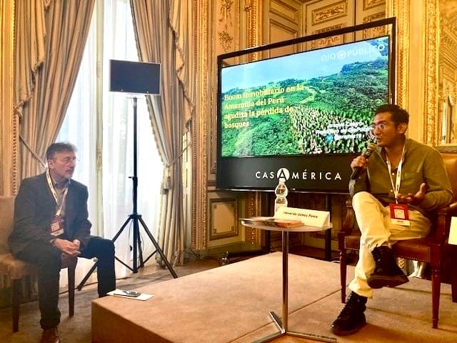
En el artículo de Castro se analiza cómo la especulación inmobiliaria está contribuyendo a la deforestación en la Amazonía peruana, lo que demuestra cómo la venta de tierras rurales está transformando regiones como San Martín y Ucayali, donde ya se han perdido miles de hectáreas de bosques.
Castro analizó cientos de anuncios en las redes sociales y descubrió que las empresas inmobiliarias privadas estaban promoviendo representaciones de edificios modernos en entornos arbolados y naturales y atrayendo a los compradores con lemas como “El nuevo Miami en la selva peruana”. Sin embargo, muchos de los lotes rústicos carecen incluso de servicios básicos de agua o alcantarillado y, a menudo, contribuyen a la degradación del ecosistema. La investigación muestra cómo la falta de regulación y control en la venta de tierras agrava la deforestación, la pérdida de biodiversidad y otros problemas ambientales.
Aramís Castro analiza su investigación sobre la especulación inmobiliaria y la degradación ambiental en la Amazonía peruana en una mesa redonda organizada por el Instituto Lincoln. Crédito: Instituto Lincoln.
Mención de honor 1: Lucía Viridiana Vergara García, Darío Ramírez, Isabel Mateos, Rodrigo Flores Esquinca, Alonso Esquinca Díaz, Erick Retana, Eduardo Mota y Eduardo Buendía, por “Aquí no cabe un tren” y “La Sedena arrasó la selva para construir 6 hoteles del Tren Maya”, producido por Mexicanos contra la Corrupción y la Impunidad en México.
En este artículo y el pódcast que lo acompaña, se analiza cómo la construcción del Tren Maya en México y los nuevos hoteles vinculados a este megaproyecto podrían causar daños irreversibles al medio ambiente, lo que contradice los argumentos a favor del desarrollo de las regiones por las que pasará el tren. El trabajo explora de manera clara y creativa el tema con ricos testimonios y plantea una serie de problemas con el proyecto: desde la tala de árboles y la falta de estudios técnicos y científicos de sus impactos ambientales hasta los efectos de la construcción en áreas arqueológicas protegidas y una biosfera declarada Patrimonio de la Humanidad por la Unesco en 2002.
En esta investigación periodística, realizada para Distintas Latitudes por la séptima generación de la Red LATAM de Jóvenes Periodistas, se explora la crisis de la vivienda en América Latina desde diferentes ángulos. Se destacan problemas, como el acceso a la vivienda, el aumento de la desigualdad y la falta de políticas inclusivas para grupos vulnerables como los jóvenes, las mujeres y la comunidad LGBTI.
En la serie, se examinan la dinámica del crecimiento urbano no planificado y cómo los gobiernos no han abordado adecuadamente la demanda de vivienda digna, y se busca arrojar luz sobre las condiciones actuales y proponer soluciones para garantizar el derecho a una vivienda adecuada en la región.
En esta serie de investigación, se describe la crisis del agua en 12 regiones de México. En el informe, se reflejan los diferentes conflictos relacionados con la falta de agua, que resultan tanto de la crisis climática como de la intervención humana directa, especialmente a través de la coerción del crimen organizado.
En este artículo, se explora el impacto del cambio climático en las condiciones de trabajo en diferentes áreas de Uruguay, desde Valizas hasta Ciudad del Plata, y se describe cómo el clima extremo afecta a los pescadores artesanales, los trabajadores domésticos y otras personas que dependen de ecosistemas vulnerables. También se aborda la desigualdad y el riesgo de inundaciones en las comunidades costeras. La investigación combina datos geoespaciales y visualización avanzada para mostrar el impacto de estos cambios.
Mención de honor 5: Vinicius Sassine y Lalo de Almeida por “Cerco às aldeias” (“Asedio de aldeas”), publicado por Folha de São Paulo en Brasil.
En esta obra, se describe cómo las empresas mineras, o garimpos, roban la tierra, el agua y la salud de los grupos indígenas mundurukú, kayapó, nambikwara y yanomami de la Amazonía brasileña. En las áreas donde operan estas empresas mineras, los habitantes sufren enfermedades debido al contacto con el mercurio, que es el metal pesado tóxico utilizado para separar el oro del suelo. Se diagnostica a los niños con retrasos cognitivos y a los adultos con enfermedades físicas. Sin embargo, el Gobierno brasileño no tiene planes de poner fin a la minería ilegal.
Imagen principal: Un camión lleva agua a Durán (Ecuador), donde casi el 70 % de los residentes ha vivido sin agua potable durante décadas. Hace poco, un proyecto plurianual que investiga esta crisis ganó un premio de periodismo del Instituto Lincoln. Crédito: Unidad de Investigación Tierra de Nadie.
Third Annual Lincoln Award Recognizes Land Policy Reporting in Latin America
In the Ecuadorian city of Durán, more than 70 percent of the estimated 325,000 residents have no drinking water or sewage service. They must purchase water trucked in by tanker companies—a precarious, seemingly untenable situation that has persisted for almost 40 years. When a team of journalists set out to investigate the reasons for Durán’s inadequate water infrastructure—and uncovered some of the government obscuration and private-sector corruption behind it—they began to receive threats of violence.
The team persevered, however, and published a multimedia investigative series that describes in vivid detail how collusion between government actors and the private sector has restricted access to the basic service of drinking water for most of Durán’s population. This fall, the Lincoln Institute of Land Policy recognized the work of two journalists involved with the project—Leonardo Gómez Ponce and another whose name is being withheld due to ongoing threats—with the 2024 Lincoln Award (Premio Lincoln) for Urban Policy, Sustainable Development, and Climate Change Journalism. Both recipients are part of the Unidad de Investigación Tierra de Nadie (No Man’s Land Research Unit). The award, now in its third year, was presented as part of the prestigious 2024 Latin American Conference of Investigative Journalism (COLPIN), and recognizes the best land policy journalism in Latin America and the Caribbean.
Ponce and other Premio Lincoln winners joined a roundtable discussion, moderated by Lincoln Institute Senior Program Manager Laura Mullahy, on Day 3 of the annual COLPIN conference, held this year in Madrid. The four-day event was organized by the Lima, Peru–based Instituto Prensa y Sociedad (Press and Society Institute), or IPYS.
The Premio Lincoln selection committee and recipients at the 2024 Latin American Conference of Investigative Journalism. The Lincoln Institute’s Laura Mullahy is fourth from left. Credit: Lincoln Institute.
Journalists submitted 265 entries for the Premio Lincoln this year, Mullahy says—more than double the number received in each of the first two years—and the entries were all over the map, both literally (representing 63 cities in 22 countries) and topically. Water shortages, climate change, and housing were prevalent subjects, as were investigations on land conflicts, climate migration, informal settlements, and illegal or unjust land use.
Mullahy says the depth and tenacity of the reporting was inspiring. Some of the winning journalists had been pursuing stories for several years. “I get sort of emotional about these awards,” she says, “because these are such dedicated people.” Mullahy was also proud that two of the winners had participated in Lincoln Institute courses for Latin American journalists in the past, which were designed to introduce them to core concepts of land policy.
Below, find the winners of the 2024 Lincoln Award for Journalism on Urban Policy, Sustainable Development, and Climate Change, along with links to their work. (See the 2023 winners here.)
2024 Premio Lincoln Winners
First Prize: Leonardo Gómez Ponce and colleague for the series, “Durán, los hijos del tren y las mafias del agua” (“Durán: The Children of the Train and the Water Mafias”), a years-long investigation published by Ecuador’s Tierra de Nadie.
The online platform for this multi-part, data-rich investigative series opens with a real-time counter tallying the more than 38 years—every month, day, hour, second—that 70 percent of residents in the city of Durán, Ecuador, have gone without drinking water or functioning sewer systems.
“This is an example of how unscrupulous businesses can limit the planning and development of a city’s infrastructure,” Mullahy says. “The selection committee valued the investigative quality, the contribution of data and supporting documentation, and the clear demonstration that without infrastructure of basic services, populations remain in poverty and no progress is possible.”
Second prize: Alexánder Marín Correa, Juan Camilo Parra, Miguel Ángel Vivas, Camilo Tovar Puentes, María Angélica García Puerto, and Juan Camilo Beltrán, for “Escasez de agua en Bogotá: ¿Cómo llegamos a este punto?” (“Water Shortage in Bogotá: How Did We Get to This Point?”), published by El Espectador in Colombia.
Produced by a group of journalists from Colombian newspaper El Espectador, this article chronicles how a combination of historical, environmental, and management factors led to a health catastrophe in Bogotá.
The article recounts how Colombia’s capital city has experienced rapid growth and increased demand for water, all while deforestation and climate change have diminished water sources. The situation is aggravated by river pollution and the lack of adequate infrastructure. The article clearly shows that water management has been inefficient, leading to distribution problems and inequitable access. This context poses an urgent challenge to guarantee the sustainable supply of water to the people of Bogotá.
Castro’s article analyzes how real estate speculation is contributing to deforestation in the Peruvian Amazon, demonstrating how the sale of rural land is transforming regions such as San Martín and Ucayali, where thousands of hectares of forests have already been lost.
Castro analyzed hundreds of social media advertisements and found that private real estate companies were promoting renderings of modern buildings in wooded, natural settings, luring buyers with slogans like, “The new Miami in the Peruvian jungle.” But many of the rustic lots lack even basic water or sewerage services, and often contribute to the degradation of the ecosystem. The research shows how the lack of regulation and control in the sale of land aggravates deforestation, biodiversity loss, and other environmental issues.
Aramís Castro discusses his investigation into real estate speculation and environmental degradation in the Peruvian Amazon at a roundtable held by the Lincoln Institute. Credit: Lincoln Institute.
Honorable Mention 1: Lucía Viridiana Vergara García, Darío Ramírez, Isabel Mateos, Rodrigo Flores Esquinca, Alonso Esquinca Díaz, Erick Retana, Eduardo Mota, and Eduardo Buendía, for “Aquí no cabe un tren” (“There’s No Room for a Train Here”) and “La Sedena arrasó la selva para construir 6 hoteles del Tren Maya” (“Sedena Razed the Jungle to Build 6 Mayan Train Hotels”), produced by Mexicanos contra la Corrupción y la Impunidad in Mexico.
This article and accompanying podcast look at how the construction of the Mayan Train in Mexico—and the new hotels linked to this mega-project—could cause irreversible damage to the environment, contradicting arguments for developing the regions through which the train will pass. The work clearly and creatively explores the topic with rich testimonials, and raises a range of issues with the project, from the felling of trees and the lack of technical and scientific studies of its environmental impacts, to the effects of construction in protected archaeological areas and a biosphere declared a UNESCO World Heritage site in 2002.
This journalistic investigation, carried out for Distintas Latitudes by the seventh generation of the LATAM Network of Young Journalists, explores the housing crisis in Latin America from different angles. It highlights problems such as access to housing, the increase in inequality, and the lack of inclusive policies for vulnerable groups such as youth, women, and the LGBTI community.
The series examines the dynamics of unplanned urban growth and how governments have failed to adequately address the demand for decent housing—and seeks to shed light on current conditions and propose solutions to guarantee the right to adequate housing in the region.
Honorable Mention 3: Aitor Sáez for “Aguas revueltas: sequía y saqueo en México” (“Troubled Waters: Drought and Looting in Mexico”), published by Pie de Página, Mexico
This investigative series describes the water crisis in 12 regions of Mexico. The report reflects the different conflicts related to the lack of water, which result from both the climate crisis and direct human intervention, especially through the coercion of organized crime.
This article explores the impact of climate change on working conditions in different areas of Uruguay, from Valizas to Ciudad del Plata, describing how extreme weather affects artisanal fishermen, domestic workers, and other people who depend on vulnerable ecosystems. It also addresses inequality and flood risk in coastal communities. The research combines geospatial data and advanced visualization to show the impact of these changes.
Honorable Mention 5: Vinicius Sassine and Lalo de Almeida for “Cerco às aldeias” (“Siege of Villages”), published by Folha de São Paulo in Brazil.
This piece describes how mining companies, or garimpos, rob land, water, and health from the Mundurukus, Kayapós, Nambikwaras, and Yanomami–Indigenous groups of the Brazilian Amazon. In the areas where these mining companies operate, inhabitants suffer from illnesses due to contact with mercury, the toxic heavy metal used to separate gold from the ground. Children are diagnosed with cognitive delays, and adults with physical illnesses. However, the Brazilian government has no plans to put a stop to illegal mining.
Lead image: A truck brings water to Durán, Ecuador, where nearly 70 percent of residents have lived without drinking water for decades. A multiyear project investigating this crisis recently won a Lincoln Institute journalism award. Credit: Unidad de Investigación Tierra de Nadie.
“Design With Nature Now” Inspires Exhibits in Taipei and Nanjing
Two new translations of the Lincoln Institute book Design with Nature Now are hitting international bookshelves this year, and with them, a pair of interactive exhibitions—one in Nanjing, China, and a second in Taipei, Taiwan—have brought the publication’s concepts and projects to life for thousands of attendees.
Design with Nature Now was published in 2019 by the Lincoln Institute of Land Policy and the University of Pennsylvania, commemorating the 50th anniversary of Ian L. McHarg’s landmark volume, Design with Nature. Published in 1969, that book helped redefine landscape architecture and introduced ecological planning principles aligned with the growing environmental movement. Edited by Penn faculty, Design with Nature Now reflects on McHarg’s enduring influence over half a century later and showcases a variety of visionary environmental design projects taking place around the world. They include a protected 2,000-mile Yellowstone to Yukon wildlife corridor, a 5,000-mile Great Green Wall of trees and shrubs being planted to combat desertification in Africa, and the transformation of what was once the world’s largest landfill into a 2,200-acre urban park and wetland habitat in New York City.
Recognizing that it would be easier for people to appreciate the enormity and scale of such massive projects when the accompanying photographs and maps were measured in feet as opposed to inches, a team at Penn—including coeditor Frederick “Fritz” Steiner, professor and dean of the Weitzman School of Design, and William Whitaker, architectural archives collections manager—curated a series of visually stunning exhibitions at the Weitzman School upon the book’s initial publication in 2019. With the work now being translated into both simplified and traditional Chinese (the former used predominantly in mainland China, the latter in Taiwan), Steiner found partners with Penn connections abroad who were eager to revive and reimagine those installations for new audiences.
Visitors explore the Design with Nature Now exhibit in Taipei. Credit: Matt Chu.
The Taiwan Institute of Landscape Architects (TILA) agreed to host an exhibition in Taipei, where the mayor is a Penn Law School alumnus; Southeast University in Nanjing, China, offered to host as well. Southeast is “the oldest school of architecture in China, and it was founded by two Penn alums, so we have a very close relationship,” Steiner says.
The Nanjing exhibition opened first, running May 31 through July 31, while the Taipei installation was open from September 14 to October 12. The exhibitions drew “thousands and thousands of people,” says Steiner, who attended both openings.
“Both venues were amazing,” Steiner says, and the settings enhanced the displays of maps and other materials related to the book: “The Nanjing exhibition was held in a kind of shopping plaza on a huge lake by the historic city wall—it’s a major subway stop and a park, a venue where a lot of people get married, so it was just swarming with people,” Steiner says. The Taipei exhibit was housed in a former tobacco factory “in the hippest cultural and arts center of the city,” he adds, at the Songshan Cultural and Creative Park.
Penn professor and Design with Nature Now coeditor Karen M’Closkey recently returned from a global landscape architecture conference that overlapped with the end of the exhibit in Taipei, and says the dynamic venue helped ensure that the exhibition was packed. “They’ve renovated all these buildings, there are small shops and bookstores,” she says. “It was busy with people the whole time, and on the pedestrian street between the buildings, there were always performances and people selling things. It was a very lively place.”
In Taipei alone, roughly 9,600 people attended the exhibition, says curator Matt Chu, deputy secretary general of the Taiwan Institute of Landscape Architects. The Taipei exhibition included guided tours, weekend lectures with Taiwanese government officials, and a two-day symposium as the installation came to a close in mid-October.
Over 600 attendees took one of the guided tours offered by TILA volunteers and adjunct professors, Chu says, each tour beginning with a deep introduction to ecological design projects and concepts in the auditorium. “Every tour was packed, and we were so thrilled by positive feedback from the audience,” Chu says.
A Taiwan Institute of Landscape Architects (TILA) member offers a guided tour of the exhibit in Taipei. Credit: Matt Chu.
Themes That Resonate
The 25 large-scale environmental design projects showcased in Design with Nature Now are organized into five major themes: Big Wilds, Rising Tides, Fresh Waters, Toxic Lands, and Urban Futures. The exhibits were likewise split into five thematic categories, but also included a section on McHarg himself, called The House We Live In, and a gallery of works by artist and landscape architect Laurel McSherry, created during her stint as a Fulbright Scholar in McHarg’s homeland of Scotland. In both Nanjing and Taipei, local government agencies augmented the exhibits by connecting the themes to their own environmental efforts around climate change and resilience.
Three of the thematic projects highlighted in Design with Nature Now are located in China—including a focus on Qianhai Water City in Shenzhen—but that’s hardly the only reason the book has found a welcome audience there.
“The importance of nature to Chinese culture is ancient, so I think there’s that historic connection,” Steiner says. “But also in a contemporary sense, it’s the biggest country in the world in terms of population, it’s become majority urban . . . so the issues of urbanization, loss of biodiversity, climate change—they’re not abstract. There’s a lot of interest politically, both in Taiwan and in the People’s Republic, in addressing these issues. I think the five big themes that we identified resonate very much.”
In addition to the larger-than-life reproductions of maps, photographs, and landscapes, the exhibits included 3D models and updated information on projects featured in the book and original exhibit.
The exhibit included a three-dimensional model of Taipei. Credit: Matt Chu.
In Taipei the exhibit included a three-dimensional model of the city. And one of Chu’s favorite installations in Taipei brought new clarity to a concept introduced in McHarg’s 1969 book. McHarg and his students had famously sliced up contoured landscapes, such as that of Staten Island, New York, into different layers—showing existing land uses alongside hand-drawn maps of the area’s physiography, water table, wildlife habitat, forest cover, and tidal inundation, among other ecological features—in an analog precursor to geographic information system (GIS) mapping.
“In the original exhibition in Philadelphia, they had those 18 Staten Island graphics on the wall,” Chu says. “But I kind of stacked them using transparent panels, so visitors can see all the different layers—the geology, the hydrology, the vegetation, all the layers—the way Ian McHarg explained how nature would influence culture and where development should go.”
A series of transparent panels map the ecological and geological features of Staten Island, NY. Credit: Matt Chu.
Five years after the Penn exhibition, Chu was also able to display updated photos from the landscape architecture firm Field Operations, which has completed early phases of two major projects featured in Design with Nature Now: Freshkills Park in New York, which was once the largest landfill in the world, and Qianhai Water City in Shenzhen. “So it’s kind of a comparison with five years ago, when they were only in the planning phase,” Chu says. “They’ve got North Park, Phase One built in Freshkills Park, and in Shenzhen they got Guiwan Park built. And you can see the process, how it’s come from the planning phase, to design, to building it, and see how designing with nature really came true.”
The exhibits also included video, notes Steiner, with displays including a snippet from a late-1960s McHarg documentary; a film by McSherry that synced the waxing spring daylight hours of Glasgow with cinematic scenes in real time; and previously recorded live-cam footage of wildlife in the Yellowstone to Yukon corridor using an underpass to cross beneath a busy road. “Kids would all be huddled around watching the animals go through the underpass,” says Steiner, who notes that the curiosity went both ways, as bears, coyotes, and other animals came up to inspect the camera at close range.
The Nanjing and Taipei exhibits were such a success that other organizations are already inquiring about hosting the exhibits next year. Steiner says the Nanjing exhibit is slated to move to Shanghai next summer, while in Taiwan, Chu says, “So far we have the Taoyuan City Library and Kaohsiung National Science and Technology Museum expressing their willingness to exhibit next year,” as well as interest from Taiwan’s Forestry and Nature Conservation Agency.
Chu said the exhibition helped raise the visibility of the landscape architecture profession locally. “Even though Ian McHarg actually came to Taiwan about 40 years ago, to help Taiwan establish its National Parks system, people in Taiwan still associate the profession more with horticulture or gardening,” Chu says. “So this exhibition really opened their eyes [to the idea] that landscape architects can help with things like climate change and biodiversity loss using large-scale planning and design.”
Jon Gorey is a staff writer at the Lincoln Institute of Land Policy.
Lead image: Visitors explore the Design with Nature Now exhibit in Taipei. Credit: Matt Chu.
City Tech
Aplicaciones de riego de árboles para el follaje urbano
Por Rob Walker, October 31, 2023
SHARE
A medida que la ciudad crece y los efectos del cambio climático se tornan más evidentes, también crece la importancia de los árboles urbanos. Los árboles brindan la sombra que tanto necesitamos, eliminan la contaminación del aire, absorben el carbono e incluso aumentan los valores de los bienes inmuebles. Pero suele pasarse por alto un elemento: una cosa es plantar muchos árboles, pero otra es preservarlos.
Durante años, la tecnología ha desempeñado un papel importante en los esfuerzos de rastrear, mapear y cuantificar los impactos globales de los paisajes arbóreos, desde lo ambiental hasta lo económico, tema que se trató en esta columna en 2018. Pero, desde entonces, surgieron y evolucionaron nuevas tecnologías, y algunas de las más interesantes se centran no solo en los impactos políticos de alto alcance, sino también en el tema crucial del mantenimiento a largo plazo. Si se espera que la población de árboles urbanos perdure, el riego adecuado y oportuno, sobre todo para los árboles más jóvenes, debe ser parte de la planificación. Y, cada vez más, las ciudades están aprovechando herramientas de datos sofisticadas para fomentar y permitir la participación de la ciudadanía en la preservación de los árboles urbanos.
Por ejemplo, CityLAB Berlin, una organización sin fines de lucro de innovación tecnológica de Alemania que aplica datos a los problemas urbanos tiene varios proyectos en curso. En los últimos años, Berlín, una de las ciudades con más árboles de Europa, perdió el 20 por ciento de sus ejemplares a causa de las altas temperaturas y la escasez de lluvias. Esto se debe, en parte, a que supervisar y preservar árboles individuales puede ser una carga ardua y complicada para los gobiernos municipales. Así que, en 2020, CityLAB lanzó Gieß den Kiez (Regar el barrio), una plataforma digital que puso a disposición del público en general datos del gobierno sobre árboles. Esto permitió que la ciudadanía pudiera informarse sobre las necesidades de riego de los árboles locales y comprometerse a ayudar. “La aplicación se desarrolló con base en las necesidades de nuestra comunidad”, expresó por correo electrónico Yannick Müller, directora de asociaciones estratégicas de la organización.
La cantidad de datos disponibles fue una revelación: los proyectos de los gobiernos habían detallado y mapeado con anterioridad cientos de miles de árboles. CityLAB, un proyecto de Technologiestiftung Berlin, fundación financiada por la Cancillería del Senado de Berlín, combinó esto con otros datos, como cifras de lluvias, para crear un mapa que asocia la actividad de riego con las necesidades específicas para cada especie para los árboles de la ciudad. Los comentarios de la ciudadanía comprometida con los árboles ayudaron a darle forma al desarrollo de la plataforma. Algunas personas ya habían adoptado y empezado a preservar árboles de forma particular. “Sienten que son sus propios árboles”, dijo la gerenta de CityLAB Berlin, Julia Zimmermann. La ciudadanía también tuvo ideas sobre cómo utilizar el sistema de bombas de agua existente en la ciudad y mejorar su asequibilidad.
“Los usuarios, grupos e iniciativas pueden interactuar entre sí a través de una herramienta de chat, que también nos permitió comunicar y recopilar opiniones”, explicó Müller. Aparte de resolver errores pequeños, esto inspiró nuevas funciones, como una que muestra la ubicación y el estado de las bombas de agua. A su vez, permitió designar “cuidadores” para árboles específicos, que se comprometen a supervisar y regar con regularidad. “La adición de esta función pequeña permite a los ciudadanos hacer uso de sus recursos de forma más dirigida”, expresó.
Residentes de Berlín usan el sistema de bombas de agua de la ciudad para ayudar a preservar el follaje urbano. Crédito: Florian Reimann.
Según Müller, en 2021, la ciudad de Leipzig adoptó la herramienta, y algunas otras municipalidades alemanas siguieron sus pasos. Los números de los usuarios no paran de crecer, y más de 3.500 ciudadanos se registraron como cuidadores de más de 7.500 árboles adoptados.
Más allá de esto, los esfuerzos de Gieß den Kiez siguen siendo un complemento de la política pública. “Sin embargo, la plataforma logra generar cada vez más conciencia sobre las adaptaciones climáticas, anticipándose a las futuras olas de calor”, sostiene Müller. En Berlín, por ejemplo, “suscitó un debate entre las diferentes autoridades de distritos locales sobre hasta qué punto la ciudadanía debería participar en el cuidado de los árboles de la ciudad y si ese uso del agua es adecuado” (Según Müller, lo es, si se consideran los costos de plantar árboles nuevos y los numerosos beneficios comprobados para la salud y el medioambiente que ofrece un follaje urbano robusto).
Una de las inspiraciones que CityLAB Berlin ha citado es el mapa de árboles de la ciudad de Nueva York (NYC Tree Map), una herramienta digital que se remonta al 2016, y que ya tiene registrados alrededor de un millón de árboles. En un comunicado de prensa de 2022, el Departamento de Parques y Recreación (NYC Parks) declaró que “NYC Tree Map es el mapa más integral y actualizado de árboles vivos en el mundo”. “El mapa, que está integrado directamente con la base de datos forestales de los parques, le brinda a la ciudadanía el mismo acceso en tiempo real al bosque urbano que los silvicultores de parques tienen en el terreno”. Esto permite que las personas de Nueva York “interactúen de forma digital” con la población forestal de la ciudad en los cinco distritos; por ejemplo, pueden supervisar la inspección más reciente de un árbol, con la fecha y la identificación de la inspección.
“Nuestro NYC Tree Map permite que los amantes casuales de árboles identifiquen ejemplares fácilmente, comuniquen sus inquietudes e informen sobre su cuidado”, explicó por correo electrónico Nichole Henderson, directora de la Administración de NYC Parks. “Grupos y personas registran en el mapa sus actividades de cuidado de árboles, como el riego, la eliminación de basura, el cultivo de la tierra y la cobertura con mantillo”.
Varios grupos usan el mapa para coordinar esfuerzos de mantenimiento y administración más ambiciosos. A modo de ejemplo, Hernderson menciona el Jackson Heights Beautification Group, una organización ambiental y artística de Queens; Trees New York, una organización profesional de larga trayectoria que capacita a “podadores de la ciudad”, entre muchas otras actividades, y la organización Gowanus Canal Conservancy, cuyos proyectos incluyen esfuerzos de “ciencia comunitaria” como experimentos sobre la captura y el uso del agua de lluvia. Y el mapa de árboles es clave para la campaña de mayor alcance de NYC Parks, Let’s Green NYC (Llenemos de verde a NYC), que publica “actividades de cuidado de árboles en las calles de toda la ciudad con socios comunitarios y permite que los voluntarios vean el impacto visible, cómo están contribuyendo directamente con el cuidado de la floresta urbana”, dijo Herderson.
En otras ciudades importantes se están llevando a cabo iniciativas similares. El Departamento de Transporte del Distrito (DDOT) de Washington, DC, mantiene un mapa de árboles digital que promueve la participación ciudadana (por ejemplo, para que informen el oscurecimiento de las hojas o el daño de insectos, así como los árboles que necesitan agua). El mapa de árboles se lanzó con un foco especial en preservar 8.200 árboles plantados en 2017. Otro ejemplo es la aplicación Adopt-A-Tree en Atenas, que permite a los ciudadanos asumir la responsabilidad del riego de árboles individuales de la ciudad durante los meses secos del verano. Y las entidades como CityLAB Berlin siguen innovando: su nuevo proyecto Árboles Cuantificados (QTrees) aspira a desarrollar un sistema de predicción respaldado por inteligencia artificial, haciendo uso de bases de datos y sensores para identificar los árboles urbanos en riesgo de secarse. Ya se está probando un prototipo, y el plan es lanzarlo este año.
Washington, DC, los residentes pueden usar la herramienta Tree Tool de la ciudad para localizar árboles según el barrio, clasificarlos por especies, edad y el cuidado que necesitan, e informar problemas. Crédito: Departamento de Transporte del Distrito (DDOT, por su sigla en inglés).
Zimmermann, de CityLAB Berlin, reconoce que fue difícil demostrar con precisión el impacto de estos esfuerzos. “Esto se debe a la naturaleza de la naturaleza”, dijo. Los árboles se adaptan con lentitud, así que estimar los efectos de los programas de riego podría requerir años de supervisión del crecimiento y la salud. Pero el tablero de datos del proyecto ilumina los patrones de riego, y mostró que las cantidades de riego aumentaron desde que el programa comenzó, y, casi con certeza, contrarrestaron los efectos de la sequía. “Así que el proyecto genera, por lo menos, un mejor entendimiento y cuidado de los espacios verdes urbanos”, añadió. En algunos casos, ha inspirado a gobiernos locales a apoyar a voluntarios, al brindarles material y lineamientos para prácticas de riego óptimas.
En una encuesta reciente sobre la valoración sorprendentemente duradera de las personas por lo arbóreo, la historiadora y autora, Jill Lepore, observó que “los árboles son los nuevos osos polares, la imagen que es tendencia en el movimiento medioambiental”. Ahora tenemos la ciencia y la tecnología para entender y cuantificar el valor de los árboles más allá de lo estético. “Si a nuestros ancestros les pareció inteligente y necesario talar los bosques rápidos, es incluso más necesario que sus descendientes planten árboles”, escribió la paisajista Andrew Jackson Downing en 1847. “Permitamos que todas las personas, cuyas almas no sean un desierto, planten árboles”. De acuerdo. Pero, también tenemos la obligación, y la tecnología, para preservarlos.
Rob Walker es periodista; escribe sobre diseño, tecnología y otros temas. Es el autor de The Art of Noticing. Publica un boletín en robwalker.substack.com.
Imagen principal: Árboles en la calle y una ciclovía emergente en Berlín, donde una organización sin fines de lucro del sector tecnológico lanzó una plataforma digital que ayuda a los residentes a informarse sobre las necesidades de riego de los árboles locales. Crédito: IGphotography vía iStock/Getty Images Plus.
What Happens When Climate Solutions Cause Problems?
In the small beachside settlement of Praia do Xavier, along Brazil’s northeastern coast, villagers have long practiced traditional raft fishing, farmed the dunes, or harvested shellfish as a way of life. They did so for generations without any infrastructure to speak of—no roads, schools, electricity, or running water—on what was common land, freely accessible to the public.
That is, until the Brazilian government allowed much of that land to be privatized so a European company could install a 50-turbine wind farm along the shoreline to capture the coastal breezes. The construction of the 2,570-acre wind farm in the state of Ceará added up to 104 megawatts of clean energy to Brazil’s electric grid when it opened in 2009, but it also drained the lagoons that villagers relied upon for winter fishing and impeded their access to other traditional fishing grounds.
Ramping up renewable energy production is a crucial climate goal, and one that Brazil has excelled at to date. But the rush to produce more solar and wind power has also led to new forms of land speculation and “green grabbing.” A study by University College London researchers found that over a third of wind parks installed in Brazil from 2000 to 2021 were built on legally dubious grounds, either on common lands or without legal titles, and most are owned by international investors.
A pair of researchers in Brazil is now studying how such land use decisions are being made, with a particular focus on the state of Ceará, and how to ensure renewable energy expansion doesn’t result in further climate injustices. Their project is one of seven finalists selected for support through a request for proposals issued by the Lincoln Institute of Land Policy in March.
“Society can’t afford to delay the energy transition or the work needed to adapt to our changing climate,” says Amy Cotter, director of urban sustainability at the Lincoln Institute. “But we need to do so in a way that avoids undermining people’s ability to provide for themselves and their families at a time when that ability is already challenged by climate change itself.” It’s a tension unfolding around the world, as governments, utilities, and nonprofits try to achieve a quick but just transition to clean energy, balancing the critical need for rapid renewable energy development with other demands on the land.
“With this suite of research, we hope to help accelerate climate action that anticipates and avoids or offsets any negative consequences,” Cotter says.
Through case studies and interviews, Flavia Collaço, visiting professor at Universidade Federal do Ceará, and Joachim Stassart, a PhD candidate at the University of British Columbia, will analyze the expert and government knowledge, technological tools, and underlying politics that inform how land is allocated for renewable energy projects, why that process often ignores traditional and communal land uses, and how it could be improved to reduce land dispossession and climate injustices as more wind and solar projects go forward.
The first stage of Brazil’s wind projects was almost all installed along the coast, Collaço says. “So it’s mainly affected small artisanal fishermen, and Indigenous people and traditional communities that live in this coastal region,” she says. “But the second stage of wind projects is coming to the countryside, and that means new challenges and new types of communities and ecosystems that are going to be impacted.”
“Brazil is a country with a lot of land conflicts and a lot of speculation related to land, but it’s usually and historically been related to agriculture,” Stassart notes. “With this renewable energy boom, there’s this new form of speculation, and it’s in areas that weren’t the target of land conflict in the past.”
Parts of rural Ceará have yet to go through a formal land regularization process, which creates potential for land conflict and speculation as renewable projects move inland. “In Brazil, it’s very common, especially in the most remote areas, that there are a lot of overlapping land claims and a lot of informality in the land sector,” Stassart says. “So people can be using the land for generations without holding a title to it . . . there are still a lot of Indigenous and local communities who don’t have access to a formal land title that recognizes their rights.”
Less than a fifth of Ceará has yet to be regularized, but much of that land is in areas now targeted for new wind and solar installations, which has set the formalization process in motion, Collaço says. “So our research is going to capture precisely the beginning of this process.”
The Lincoln Institute selected six other projects to support through this RFP, many of which focus on curtailing “green grabbing” practices:
Researchers from the SD Dombo University of Business and Integrated Development Studies in Ghana will perform a literature analysis and empirical case study on the rise and fall of land-based biofuel investments in Sub-Saharan Africa, to understand why most of these projects have failed, collapsed, or been abandoned.
National strategies for reducing biodiversity loss and land-based emissions are often isolated as separate policy goals, despite their obvious connections. A team from the University of British Columbia, University of Melbourne, and the Land Gap research collective will examine the feasibility of including national strategies as part of a just transition, identifying both the role and the limitations of domestic policy in addressing the drivers of deforestation.
An international and interdisciplinary team led by the German Institute for Global and Area Studies will assess the impacts of land-intensive carbon-offset projects on the livelihoods of local communities in Madagascar and Indonesia, and the effectiveness of sustainability standards in addressing these impacts.
An environmental consultant affiliated with the University of Lausanne in Switzerland will look at how the establishment of protected areas for conservation purposes over the past century has often led to conflict or even outright tragedy for Indigenous peoples and local communities, with the goal of drawing lessons for how large-scale ecosystem and forest restoration projects can avoid having the same negative impacts.
In Central Appalachia, corporate landowners have long extracted resources and value while leaving locals impoverished. As the region’s forests draw interest for their carbon sequestration potential, a University of Colorado at Colorado Springs researcher will use power mapping, interviews, and data analysis to evaluate the initial outcomes of the Family Forest Carbon Program. The new endeavor, by the American Forest Foundation and The Nature Conservancy, aims to enroll small landowners in Kentucky and West Virginia as beneficiaries of the expanding carbon market.
A team from the University of Technology Sydney will look at emerging community partnership models in Australian cities that have allowed community-driven conservation efforts to reach scale and expand their impact by overcoming common barriers to such initiatives, including a lack of secure land and stringent land use planning standards.
To learn more about all Lincoln Institute RFPs, fellowships, and research opportunities, visit the research and fellowship opportunities section of our website.
Jon Gorey is a staff writer at the Lincoln Institute of Land Policy.
Lead image: Wind turbines at Canoa Quebrada Beach in Ceara, Brazil. Credit: Cristian Lourenço via iStock/Getty Images Plus.