El Lincoln Institute of Land Policy convoca a periodistas de toda América Latina a participar del concurso “Premio Lincoln al periodismo sobre políticas urbanas, desarrollo sostenible y cambio climático”, dirigido a estimular trabajos periodísticos de investigación y divulgación que cubran temas relacionados con políticas de suelo y desarrollo urbano sostenible. El premio está dedicado a la memoria de Tim Lopes, periodista brasileño asesinado mientras hacía investigación para un reportaje sobre las favelas de Rio de Janeiro.
Convocamos a periodistas de toda América Latina a participar de este concurso. Recibimos postulaciones para el premio hasta el 9 de agosto de 2024. Para ver detalles sobre la convocatoria vea el botón “Guía/Guidelines” o el archivo a continuación titulado “Guía/Guidelines“.
The Lincoln Institute provides a variety of early- and mid-career fellowship opportunities for researchers. In this series, we follow up with our fellows to learn more about their work.
When Sonali Abraham began studying urban water use and efficiency at the University of California, Los Angeles in 2016, the region was emerging from a years-long drought—making it a great case study in water conservation attitudes and actions. A few years later, she completed her PhD with the help of a Babbitt Center Dissertation Fellowship, which assists doctoral students whose research advances water sustainability and resilience; she’s now a senior researcher at the Pacific Institute, an Oakland, California-based nonprofit focused on global water challenges and solutions.
In this interview, which has been edited for length and clarity, Abraham reflects on people’s misconceptions about sustainable landscapes, why water too often gets taken for granted, even in arid climates, and how schools can play a key role in urban stormwater capture.
JON GOREY: What is the focus of your research, and how did your Babbitt Dissertation Fellowship help you build upon that work?
SONALI ABRAHAM: I got the Babbitt Dissertation Fellowship in early 2020. I had finished all the in-person research for my dissertation, and it just came at such a fortunate time, going into a year where everything was so uncertain because of COVID. My dissertation was mainly focused on water efficiency, especially outdoors.
The big drought had just come to an end, so there was still an awareness in LA and the southwestern US that we all need to conserve water. But when it came to outdoor water use, there was this disconnect. You still had people with pretty significant lawn areas or fountains in their yard. LA is a cool case study, because you have both extremes: You have the people who are really good about conserving water and super aware, but you also have people who have the means to not care.
A national map illustrates the severity of California’s drought in 2016, the year Sonali Abraham began studying urban water use and efficiency at UCLA. The multiyear drought eased up the following year, but the state experienced another drought in 2020-2022. Credit: NOAA.
I went into it first looking at how people are using water outdoors: Are we seeing a big difference in seasonality, or when there’s a drought year? How are different demographics and different communities using water outdoors? And then I focused in on the commercial sector, because I realized there was a big gap in our understanding of how commercial properties used water.
One of the big things is that they’re not metered separately. You’ll have one big building with different offices in it, and everything’s on one water meter, so you don’t know how much a single office uses. And then it’s also regulated differently. They put in conservation restrictions around the drought, but almost everything was focused on the residential sector. . . . So it was trying to understand, did commercial spaces reduce water use during the drought? Where are they using their water, what kind of landscapes are they using?
And as the final solution to all of this, what are the sustainable landscapes that we can put in place that will save water but also look good? We want to try to change this misconception that sustainable landscapes are ugly; they’re not just a pile of rocks or random cacti, they’re beautiful in their own right. You can have a sustainable landscape that saves water and resources but still have a really beautiful front yard that you can be proud of.
JG: What are you working on now or looking to take on next?
SA: One of the cool projects that I’m working on right now is looking at stormwater capture opportunities around schools in LA. The Los Angeles Unified School District is one of the biggest landowners in LA, and there are a lot of paved areas, so there was a lot of concern in the last year about the urban heat island effect on schools because of all the concrete around them and the intense high temperatures. You can take out that impermeable surface and create really healthy environments, both helping the children who are attending the school every day, but also the environment in the community around it, in so many different ways.
In Los Angeles County there’s this program called Measure W that taxes paved or impermeable surfaces per square foot, so there’s a big incentive for people to change it out. And that school project is a really cool example of that. The school district worked with a local nonprofit, Amigos de los Rios, and did a really good job [replacing almost half an acre of pavement from the schoolyard]. It’s a beautiful project. They did great stakeholder engagement, it’s a great example of how things can be done collaboratively and in a smart way.
The nonprofit Amigos de Los Rios has led schoolyard transformations at more than 16 schools in Southern California, including Mary W. Jackson Elementary School in Altadena. The projects replace pavement with green schoolyards designed to improve health and educational outcomes. Credit: Amigos de Los Rios.
JG: You’ve lived in many places around the world, from the Middle East to South Asia to both American coasts—some with an abundance of water, others facing a worrying scarcity of it. Have you seen interesting contrasts or similarities in the way people think about water in different regions or cultures?
SA: The similarity is that people undervalue water in general, I think that’s a through line. Both when you have a lot and when you have a little, people just have this impression of water being limitless. When you see bodies of water, I think there’s an impression of it being neverending.
It’s been interesting to see the shift in what policy is focused around based on where you are. When I was in India doing my undergraduate degree, it wasn’t so much about supply or scarcity—sometimes it would be in excess—but where I was specifically, it was about water quality. And so the things that you focus on, the way that water is talked about in common culture and society, is very different from how it’s talked about here, or in the Middle East, where I grew up, where it’s all about scarcity.
JG: What do you wish more people knew about water conservation?
SA: It’s the every-little-action-matters piece. It’s boring, but I think it’s important. We’re doing a study right now at Pacific Institute looking at a national assessment of water efficiency potential—so, how much water can we save across the country if we did X, Y, and Z. These are really basic technology-based changes, like efficient faucets—not behavioral changes—and you’d be surprised at how much of an impact those can make. People easily dismiss those kinds of small changes and feel like, ‘It’s just me, it’s just one bathroom,’ but those things add up pretty quickly.
JG: When it comes to your work, what keeps you up at night? And what gives you hope?
SA: The equity piece, especially in an international context. The issues facing different regions of the world vary a lot, and water doesn’t follow country borders. But the way that people approach problems is often on a very political basis, and that worries me. I see how it’s used as a weapon in a lot of places, and that is scary. I am hopeful that there is a path forward as people do more research and the word gets out more that these things have to be managed as a resource for a community as a whole—and that community can be your neighborhood, it can be your city, it can be the world, because it literally crosses all those pieces.
The scale at which things are going is really heartening, the awareness is only going up, and it’s going up at a much more rapid pace than when I first started this work. When I tell people I work in water, there’s often excitement and interest and people have questions and want to know more. It’s unfortunate that climate change is kind of one of the drivers that have led people to become more aware, but it’s great that people are getting more aware.
I also think we’re seeing a lot more policy that actually does drive change from the ground up. So in most California cities, you’ll see that the gallons per person per day that people are using have actually steadily decreased. Even though the population is increasing, the water usage per person is decreasing because of changes that we’ve implemented through policy for buildings and new development.
JG: What’s the best book you’ve read lately?
SA: I have a great book recommendation I tell everyone to read, it’s called The Covenant of Water. It’s fiction, it’s written by Abraham Verghese, a doctor turned author. I can’t give away too much, but it’s set in South India, where my family’s from, so it has a personal connection for me. It’s part medical mystery, part family fiction, and part cultural awareness of water and how, outside of all of the scientific, technical pieces of it, water just holds this visceral importance to a lot of communities and how they’re connected to it.
Jon Gorey is a staff writer at the Lincoln Institute of Land Policy.
Lead image: Sonali Abraham. Credit: Courtesy photo.
The Lincoln Institute provides a variety of early- and mid-career fellowship opportunities for researchers. In this series, we follow up with our fellows to learn more about their work—from building housing in New Orleans to conserving water in the West, from developing new tax appraisal tools to studying how post-pandemic retail patterns intersect with land use.
Exploring the New Economics of Downtown
Economist Lindsay Relihan has spent years studying the connections among cities, technology, consumption, and our shifting shopping habits. We caught up with Relihan, a participant in the Lincoln Institute Scholars Program, to find out what she’s learning in the wake of the pandemic.
Mapping Our Most Resilient Landscapes
As director of The Nature Conservancy’s North America Center for Resilient Conservation Science, ecologist and former Kingsbury Browne fellow Mark Anderson is leading a comprehensive mapping project to document connected, climate-resilient landscapes.
Building Affordable Homeownership Opportunities in New Orleans
After Hurricane Katrina struck in 2005, housing in New Orleans became scarce and expensive. Fulcrum Fellow Oji Alexander (shown above) is working to expand affordable homeownership opportunities in the city and address the racial wealth gap.
Designing a New Approach to Property Tax Appraisals
Appraising property is a complicated undertaking, but new tools are democratizing and modernizing the field, including an approach developed by Paul Bidanset, a former C. Lowell Harriss Dissertation Fellow at the Lincoln Institute.
Rethinking Stormwater Management in the West
Former Babbitt Center fellow Neha Gupta is a joint assistant research professor of hydrology and atmospheric sciences at the University of Arizona. We caught up with her to talk about climate change, urban stormwater, and her favorite cli-fi novels.
Jon Gorey is a staff writer at the Lincoln Institute of Land Policy.
Lead image: Oji Alexander, CEO of People’s Housing+ in New Orleans and a former Fulcrum Fellow, in front of two People’s Housing+ homes. Credit: Courtesy photo.
Incorporating Water into Comprehensive Planning
Manual
The Babbitt Center for Land and Water Policy authored a manual to help land use planners incorporate water management into comprehensive plans. The comprehensive plan and its development process provide an opportunity for a community to bring goals and policies for water issues to the forefront of their future vision, solicit public input, and foster public buy-in for a more sustainable future. This manual demonstrates how land use planners can facilitate a comprehensive planning process and resulting plan that will ensure integration of water management into their community’s future vision, as well as the water-related topics such a vision might include.
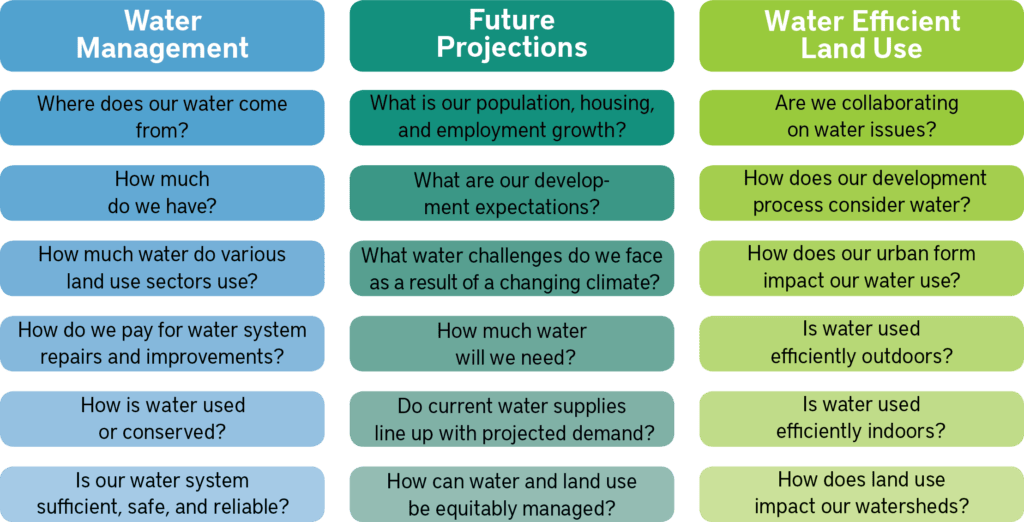
The questions below prompt a land and water planning team to consider the water issues that may be relevant to their comprehensive plan. These questions supplement the Water Topics and Examples sections that form the bulk of the Incorporating Water into Comprehensive Planning manual. These questions can be used to quickly generate ideas about water topics that may be pertinent to a community, or identify topics that require additional data or information to answer and address. Further, these questions could be used in a public brainstorming workshop to gauge community members’ knowledge and values about local water issues.
Water-Related Questions to Answer in a Comprehensive Planning Process
Questions to guide integration of water management into comprehensive planning
Evaluation
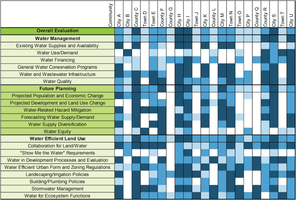
The Babbitt Center reviewed comprehensive plans in the Colorado River Basin to evaluate the degree to which communities have integrated water management into their land use plans. These plan reviews were conducted using a matrix of 20 criteria and a scale that assigned a weight to the level of implementation of the criteria. Findings from this review, and examples from communities across the Colorado River Basin, are included in our manual.
Background
The Babbitt Center’s review of comprehensive plans throughout the Colorado River Basin sought to determine
the state of land use and water planning integration in Colorado River Basin communities and;
the gaps and opportunities to be addressed in land and water planning and management practices.
Comprehensive plans may not represent the whole suite of land and water planning activities in a community, but they reveal important information about which communities, regions, and states are incorporating water into foundational land use planning processes. Furthermore, they provide an opportunity to engage the public on water issues and can lay the groundwork for linking water to other land use processes, such as development review, zoning, data and modeling, or ordinances.
Methods
The Babbitt Center worked extensively through literature, peer, and plan review to identify water topics appropriate for inclusion in a comprehensive plan. This included an initial phase of plan reviews focused on Arizona and Colorado communities, followed by a revision that resulted in more broadly applicable evaluation categories and a matrix.
Sample Evaluation Matrix
Sample plan evaluation matrix for fictitious jurisdictions, where darker blue coloring indicates that the criteria is described in the plan alongside actions for implementation and stronger land and water planning integration, and lighter blue coloring indicates that the criteria is described in the plan in very general terms and weaker land and water planning integration.
Project Progress
The Babbitt Center continues to review plans and share insights about water in comprehensive planning through presentations about the work and by consultations with communities on how to integrate water management into their comprehensive plans.
Anne Castle, senior fellow at the Getches-Wilkinson Center for Natural Resources, Energy, and the Environment at the University of Colorado Law School is a co-author.
Erin Rugland, former Program Manager at the Babbitt Center for Land and Water Policy is a co-author.
The Babbitt Center for Land and Water Policy is a project funder.
The Colorado Water Conservation Board is a project funder.
The Problem
The State of Colorado has required retail water providers serving 2,000 acre-feet or more to submit Water Efficiency Plans (WEPs) since 1991. In 2015, Colorado Senate Bill 8 stipulated that WEPs must evaluate “best management practices for water demand management, water efficiency, and water conservation that may be implemented through land use planning efforts.” Colorado has provided extensive guidance on the preparation of these plans; however, new requirements for incorporating land use practices into WEPs were not covered in the previous guidance. The Addendum bridges this gap.
The Addendum, adopted by the CWCB in January 2019, includes land use best practices that can be implemented by water providers, either independently, or through collaboration with a land use authority. It is tailored to Colorado communities, uses numerous examples and additional resources, and is designed to be adapted as applicable to varying local circumstances.
Methods
The Addendum was developed through an extensive review of literature on integrating land use and water planning; interviews with ten Colorado water providers; valuable input from regional experts; and a workshop focused on the use and readability of the guidance.
Taking the Addendum into Action
The Babbitt Center and Water Education Colorado worked to educate practitioners, consultants, engineers, and other stakeholders about the Addendum during the fall of 2019. This education and outreach included two webinars hosted in collaboration with Colorado’s Special District Association and Colorado Municipal League, and four workshops around Colorado. Watch the webinars below.
Growing Water Smart is a joint program between the Lincoln Institute and the Sonoran Institute, and the partnership has expanded to include numerous other contributors like Utah State University’s Center for Water Efficient Landscaping (CWELL) delivering workshops that introduce communities to the full range of collaboration, communication, public engagement, planning, and policy implementation tools to realize their watershed health and community resiliency goals. Through Growing Water Smart, communities learn to better integrate land use and water planning.
Watch the Growing Water Smart video to learn more about the program and participant experiences.
Workshop Format
The workshop brings key community staff and decision-makers on water and land use planning together and takes teams through facilitated discussions that set common goals around land use and water. The community teams ultimately develop collaborative action plans tailored toward local needs. Growing Water Smart workshops provide the time and space for focused team discussions and offer an opportunity to learn from peers and experts about the challenges and opportunities of achieving a secure water future. Participating teams spend much of their time defining their water resilience goals and a path to attain them. Teams develop action plans on behalf of their communities and commit to post-workshop implementation activities to advance those action plans.
State-Specific Resources
A unique curriculum is designed for each state that hosts Growing Water Smart. This includes a Community Self-Assessment and Guidebook that are tailored to the legislative requirements of that state and features local examples of land and water integration. We currently have these resources for Arizona, California, Colorado, and Utah.
Recognition
At the 2019 American Planning Association (APA) Colorado Chapter Conference held in Snowmass Village, Colorado, the Growing Water Smart program was awarded the 2019 APA Colorado Honor Award in the category of Sustainability and Environmental Planning.
Join Us
Participants in the February 2020 Arizona Growing Water Smart Workshop
Participation in Growing Water Smart is by application on a biannual basis. Selection criteria is based upon:
Diverse team composition including board members and senior staff from the town and/or county, such as:
Elected officials and planning commissioners;
City/town/county managers;
Water utility and water resource managers;
Land use planners;
Regional planning organizations;
Economic development staff;
Public health planners;
Consultants employed by the town or county; and
Developers.
Whether the desired outcomes demonstrate readiness to focus on thoughtful land use and water planning integration and if they are cohesive with the stated goals.
Firm commitment to participate and leadership to coordinate team activities, such as completing a community self-assessment and taking part in orientation activities. The workshop is offered at no cost for community teams selected and teams can apply for further technical assistance after the workshop’s conclusion. Overnight accommodations and most meals are provided, however travel to and from the workshop is not covered for in-person workshops, which are typically held retreat style.
For more information about upcoming workshops and the application process please contact Kristen Keener Busby at kbusby@lincolninst.edu or 602-566-7570 or visit growingwatersmart.org.