This article is copublished with the American Planning Association’s Planning magazine.
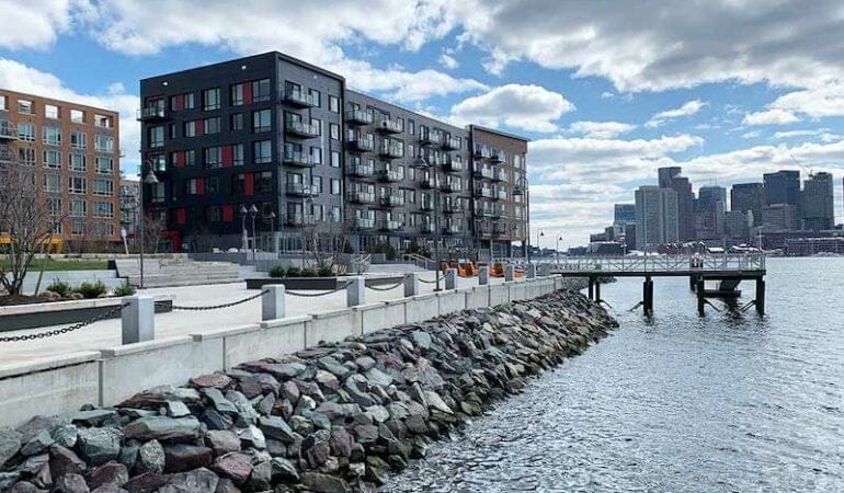
After a severe winter storm in 2018, a dumpster broke free of its moorings in Boston’s warehouse district, and started floating, almost serenely, down a flooded street. Someone captured the scene on video and it went viral, prompting headlines that the rapidly developing area should be renamed the “Inundation District.”
For the planners, engineers, and others in eastern Massachusetts who have been working to prepare for the inevitable impacts of climate change—a projected 40 inches of sea level rise, and the creeping storm surge and high-tide flooding that comes with it—there have been no shortage of such omens. The constant reminders of a wetter future suggest a race against time for a place rated the 8th most vulnerable among coastal cities worldwide, in the company of New York, New Orleans, and Miami.
While reducing carbon emissions is ongoing — Massachusetts recently passed a climate bill with firm net-zero limits for 2030 and beyond — the business of building resilience has been a priority for Boston and surrounding communities for the last several years. The looming crisis is made clear in maps projecting flooding over low-lying areas and all the extensive filling of tidal flats and marshes and other land creation that has been done over centuries. Without action, thousands of acres could be underwater, destroying homes and businesses in a terrifying transformation of the metropolitan region.
The work has been, by necessity, at the local level, without a federal organizational framework, guidance, or funding for the last four years. “With the absence of the federal government, cities like Boston have really had to step up and chart their own path in climate planning and climate resilience,” says Deanna Moran, AICP, director of environmental planning at the Conservation Law Foundation. That has meant doing careful measurement of where the flood paths are and what neighborhoods are most vulnerable, which has helped establish a detailed blueprint for targeted interventions. (Indeed, Boston is hardly alone, as is noted in APA’s Climate Change Policy Guide. “Planners have the expertise, perspectives, and skills to lead the local and regional responses to the climate crisis — but require federal and state action to amplify local planning efforts.”)
Now, with the COVID stimulus bill and another $2 trillion infrastructure package being debated in Washington, the Boston region finds itself at a pivotal moment. Funding for large-scale measures may be on the way, but that has also ratcheted up the pressure to make the right choices for effective and long-lasting protection. Confronting sea level rise here has become an extraordinary puzzle of private development, government regulation, concerns about equity, and the prospect of some areas being restored to a natural state, ultimately requiring people and places to relocate.
Years in the making
Like many coastal communities under threat, Boston has gone through early iterations of what to do, including a giant barrier stretching from Hull in the south to Winthrop in the north, protecting Boston Harbor. A 2018 study concluded the $9 billion proposal would not be cost-effective. Design competitions run by the Boston Society of Architects and the Urban Land Institute have also produced futuristic schemes like turning Back Bay streets into canals.
The search for innovative solutions continues still in the spirit of trial and error, but much of the work has settled into more down-to-earth measures: raising streets, building berms and barriers, and putting in emergency flood gates that can be deployed before a storm, for example—all based on a more precise knowledge of where the water actually goes, when it penetrates the inlets and low-lying areas in the most flood-prone areas.
Boston has already overhauled parks in the Seaport and the North End, to protect recreational facilities by giving the water different places to go. A similar approach is envisioned at Joe Moakley Park in South Boston, set to be protected by a long berm and sand dunes along the nearby beach, as a first line of defense; beyond that, flooding will be managed through a kind of re-ordering of land forms, steadily rising in elevation like a series of terraces. The playing fields can absorb some water, but the goal is to keep them as functional open space.
In addition, zoning, building codes and guidelines, and other land-use regulations are being adjusted to encourage floodable basements and parking garages, and moving mechanicals to higher elevations. Boston published a draft of Coastal Flood Resilience Design Guidelines in 2019 to begin to tackle better building design—although in terms of strict rules, local governments can’t exceed the statewide building code. Developers are also being asked to pitch in by recreating natural systems that act like a sponge, seen in the living shoreline experiment adjacent to the luxury residential development Clippership Wharf in East Boston.
Flooding knows no boundaries
Under the administration of Mayor Martin J. Walsh, who has since become U.S. labor secretary in the Biden administration, the city of Boston has led the way in climate adaptation, with the initiatives Resilient Boston Harbor, concentrating on 47 miles of shoreline, and the broader program Climate Ready Boston. (The Climate Ready Boston Report received a National Planning Achievement Award for Resilience — Gold from APA in 2019.) Yet it is readily apparent to everyone working in resilience that efforts need to be coordinated across multiple municipalities and coastal jurisdictions, since flooding doesn’t care where the town line is.
“The goal is to have a statewide flood risk model and everyone is planning for those same risks,” says Richard McGuinness, Boston’s deputy director for Climate Change and Environmental Planning. “Whether it’s Dorchester down to Quincy, or the flood paths coming into East Boston from Winthrop and Revere — regionally we see the need to determine where the action should occur. The ocean is an infinite source of water.”
McGuinness envisions a series of interventions similar to Frederick Law Olmsted’s Emerald Necklace — at its core a sanitation and flood-control public works project — extending across jurisdictional boundaries.
Frederick Law Olmsted created the Emerald Necklace by transforming a sewage-clogged swamp into parkland. Credit: 1894 map courtesy National Park Service/Olmsted Archives.
Although Massachusetts cities and towns are famously decentralized, especially in land use, a framework for regional collaboration is already in place: the Metropolitan Mayors Coalition, representing 15 eastern Massachusetts communities and 1.4 million residents, established by the Metropolitan Area Planning Council, the regional planning agency for Greater Boston.
The fiscal implications of rising seas will also get even more complicated if individual municipalities attempt to go it alone, according to Linda Shi, assistant professor at Cornell University’s department of city and regional planning.
The rules on coastal development in the 21st century simply can’t vary from one town to the next, and in fact, she says, larger-scale regional measures like the transfer of development rights and relocation through land assembly or land readjustment will be necessary. Individual nature-based solutions are fine, Shi says, but ultimately the coming transformation of coastal communities requires a broader consideration of land policy. The metaphor she invokes is a larger sheet cake, rather than individual cupcakes here and there.
A similar concern is threaded through the matter of equity. All along the East Boston waterfront, new high-end development can prompt the one-two punch of gentrification and potential flooding impacts that could get past the new building and swamp the working-class neighborhood two blocks inland, says Magdalena Ayed, founder and executive director of The Harborkeepers, a grassroots coastal resilience organization. A more uniform standard is needed to spell out the obligations of private developers to help protect the community at large, she says.
Planning, and more specifically scenario planning, can help clarify all the tricky elements inherent in building climate resilience, says Amy Cotter, director of climate strategies at the Lincoln Institute of Land Policy. “We can wait for different events to happen and react as best we can at the time, accepting the immediate loss of property and life and the cumulative effects on our communities and prosperity,” she says. “Or we can think through the different ways in which climate change will be felt and prepare for them, increasing our ability to withstand them and bounce back, and guarding against the unintended consequences of snap decisions made during crisis. Scenario planning is a great way to think about what could happen and what you’ll do as different things occur and indicate the way the future is unfolding.”
Laying out different scenarios for the future of a given area can be a sobering exercise, but one that reveals the wisdom — and the cost — of resilience interventions. Cornell’s Shi put together a case study for the town of Hull, Massachusetts, a seaside community south of Boston on the front lines of rising seas, that projects outcomes of a range of actions, from doing nothing, building a seawall, micro-protection measures like elevating homes and businesses, or pulling back to higher ground and restoring natural ecosystems. Projected costs ranged from $600 million to over $2 billion, further clarifying the stark realities of the challenges such coastal communities are facing.
A 2019 case study outlined scenarios for 2060 for Hull, Massachusetts. It showed that staying in place and just elevating roads and buildings would cost the city more than $98.8 million and single-family homeowners more than $145 million. Photo Credit: Courtesy of Howderfamily.com.
Though unpleasant, facing up to the massive disruption that rising seas will bring is critical to ensure the long-term effectiveness of resilience measures — in contrast to doing just enough to buy time. In his new book, Moving to Higher Ground: Rising Sea Level and the Path Forward, oceanographer John Englander praises the Boston area’s resilience planning — but argues it doesn’t go far enough. (Read the Planning book review.)
“Boston really is as good as it gets in the U.S. I hold up Boston and Singapore as places that are thinking futuristically,” Englander said in a recent interview. But, he adds, a truly sophisticated approach would be to plan for not three and a half feet of sea level rise, but 10 feet, over a 100-year time frame. “As good as Boston’s current plan is — and it is among the best in the world at the moment — they’re not thinking big enough. Nobody’s thinking big enough.”
As radical as some engineering solutions may sound at the moment, they could be made to be adaptable—even something as simple as the foundation of a bridge being designed to relatively easily increase its clearance as necessary. Building in that kind of flexibility in the design of infrastructure is increasingly accepted practice; what is required is a further conceptual leap, on a topic that already strains the imagination. So it is that the last few years of planning and policymaking around climate resilience, as earnestly as it has been undertaken over the last several years, is just a start.
Anthony Flint is a senior fellow at the Lincoln Institute of Land Policy and a contributing editor of Land Lines.
Photograph: A luxury residential development in East Boston sits in one of several flood paths the city has identified. Developers have raised elevations and re-created natural systems to help absorb inundation, but some wonder whether it will protect residents of the working-class neighborhood two blocks inland. Credit: Photo courtesy Anthony Flint.
Resilience District Concept Gathers Momentum in Seattle
By Emma Zehner, Abril 21, 2021
SHARE
Residents of the Duwamish Valley, a section of Seattle perched just south of downtown, face an array of environmental challenges, health disparities, and racial inequities. Saddled with a legacy of pollution from the heavy industry and highways nearby, they now face increasing flood risks due to climate change and concerns about displacement and affordability. The riverside neighborhoods of South Park and Georgetown have historically relied on community organizing to attempt to address these problems. But in recent years, the city of Seattle has taken a more active role in advancing environmental justice and equitable development in the Duwamish Valley by creating a cross-departmental Duwamish Valley Program, implementing the Duwamish Valley Action Plan, and collaborating with local activists and residents in new ways. Now, partners from the city and the community are exploring the feasibility of creating one of the nation’s first resilience districts.
Resilience districts have been implemented in New Orleans, Louisiana; Portland, Oregon; and other cities around the world. Although they sometimes go by other names, the basic concept is the same, as described by the city of Seattle: “a geographic strategy . . . focused on adapting to flood risk and other climate change impacts as a key first step towards adapting to a changing climate, while taking a comprehensive approach that fosters community resilience.”
Seattle’s approach specifically aims to coordinate investments in infrastructure related to affordable housing, parks, and climate change adaptation; prioritize the partcipation and decision-making of local residents and businesses, with a focus on building power and wealth for people of color and individuals with low incomes; and foster health and equity by identifying sustainable funding sources and equitable investment mechanisms, including value capture. The district will initially be managed by various city departments but will ultimately be led by the Duwamish Valley communities, who will establish partnerships with agencies, philanthropy, and private entities.
Credit: Blank Space LLC for the city of Seattle.
The vision for a resilience district, which had previously been discussed internally by city staff and community partners, turned into a concrete plan through partners’ participation in Connect Capital, a program run by the Center for Community Investment that helps place-based teams establish shared priorities and create pipelines of investable projects. Participants in the two-year process included representatives from Seattle Public Utilities (SPU); the city’s Office of Sustainability & Environment (OSE), Office of Planning & Community Development (OPCD), and Office of Economic Development (OED); the Seattle Foundation; the Duwamish River Cleanup Coalition (DRCC), a group of community, tribal, environmental, and small business groups impacted by pollution and remediation along the lower Duwamish River; and other stakeholders.
With planning now underway, city representatives are learning from models around the globe—from Brazil to New Zealand—that offer insights into how to equitably finance related projects, collaborate across sectors, and adapt to sea level rise. Funding from the Robert Wood Johnson Foundation (RWJF), granted at the end of 2020, will enable the project’s partners to take important next steps related to planning and piloting key elements of the resilience district.
“The community has been leading and working on these issues for decades, so it is really exciting to now see this work recognized and given support on the national level in ways that match the creativity and bold solutions being put forward by them,” Alberto J. Rodríguez, Duwamish Valley advisor at OSE and project colead, said. “This approach will allow us to collaborate in transformational ways.”
“This grant will make it possible for community groups, industrial businesses, public sector agencies, utilities, the port, and the county to continue to work together to address environmental hazards and build a more resilient community,” said Omar Carrillo Tinajero, associate director of innovation and learning at the Center for Community Investment. “Even in this difficult time, this work recognizes the importance of taking action to create a more equitable, smarter climate future.”
Project Background
Seventy percent of the residents of the Duwamish Valley’s two primary neighborhoods, South Park and Georgetown, identify as people of color. The environmental hazards they face include industrial pollution in the lower Duwamish River, which was declared a Superfund site in 2001; air pollution from State Highways 99 and 509 and Interstate 5, which all cut through the area; a lack of green space; and other challenges. During a community-run mapping exercise, residents identified noise pollution, vacant lots, a lack of healthy stores, and litter as additional “unhealthy” features. These factors have combined to create an average life expectancy eight years shorter in this zip code than in the city of Seattle and King County overall, and a full 13 years shorter than in more affluent, less diverse neighborhoods in Seattle. Further, by 2104, the routine flooding in this low-lying area is expected to become a daily occurrence.
Credit: Blank Space LLC for city of Seattle.
While the city has made efforts to address these problems, some of these actions have raised concerns among residents about displacement. SPU’s plans to invest $100 million in stormwater management infrastructure in the area and Seattle Parks & Recreation’s plans to improve and add parks, for example, have prompted increasing worries about displacement of current residents in a city with few affordable housing options. A 2015 analysis by Governing revealed that of seven U.S. Census tracts in Seattle that had experienced gentrification since 2000, five were in Georgetown and South Park, with median home values increasing an average of 47 percent between 2000 and 2013.
“We cannot be talking about a water treatment facility that is going to bring open space without thinking of displacement,” Paulina López, executive director of DRCC, said. Collaboration is critical, she said: “Our public utility doesn’t build affordable housing, but it should still be collaborating with the Office of Housing and other departments on its infrastructure investments.”
Since forming the Duwamish Valley Program in 2016, the city has commited to furthering social justice in policy and development, aiming to coordinate priorities across 18 city departments and strengthen relationships with community partners. Participating in Connect Capital helped the team shift from a focus on discrete projects and “symptoms” to a more proactive systems mindset, according to Rodríguez.
Throughout this partnership development and capacity building work, anti-displacement has repeatedly emerged as the top priority for residents. Departments such as OPCD and the Office of Housing are taking steps to address these concerns, including providing funding for capacity-building to the Duwamish Valley Affordable Housing Coalition (DVAHC), which was formed in 2017 to preserve existing affordability, develop a multipurpose community building, provide repairs, and acquire lots to build additional housing. The city is also buying land for affordable housing and providing $910,000 to Habitat for Humanity to build 13 two-bedroom, two-bath homes in South Park, which will be sold for $210,000 for a family with an annual income averaging $45,000 (in February 2021, the median list price of homes in this neighborhood was $525,000).
“We are working to shift to a culture of pairing community development with concrete anti-displacement actions,” said David W. Goldberg, strategic advisor with OPCD and project colead. “It looks like in the next few years the neighborhood will get both a park and new affordable housing.”
Mayor Jenny A. Durkan with the Duwamish Valley Youth Corps at an Earth Day celebration of Duwamish Alive! Credit: Alberto Rodríguez.
Planning: Local and International Models & Inspirations
The partners are thinking of the resilience district timeline in three stages, says Goldberg: “norming, forming, and performing.” At each of these stages, representatives from the community, philanthropy, and city will play evolving roles. During the “norming” stage, the city and community are organizing listening sessions and researching precedents. In the second stage, the city plans to develop regulatory options for enabling legislation and amendments to development standards. By the third phase, the community would hold the largest role and begin to cogovern the district, with the city playing a financing and legislative role.
With the funding from RWJF, the Duwamish Valley Program will focus on “norming” and “forming” by researching promising practices for three aspects of the district: cross-sector collaboration, sustainable funding sources and equitable investment mechanisms, and adaptation to sea level rise. The partners have already identified models in places as far-flung as San Juan, Puerto Rico, São Paulo, Brazil, and Christchurch, New Zealand, that are using strategies that could be adapted in the Duwamish Valley.
“We have built this concept from the needs of the community,” Rodríguez said. “As a result, we cannot find one model elsewhere that perfectly aligns with our work, but we have found bits and pieces that embody key aspects of the work that we want and plan to do.”
Cross-Sector Collaboration in San Juan
In communities along Caño Martin Peña, a tidal channel on the San Juan Bay National Estuary, residents face challenges familiar to the Duwamish Valley, including displacement pressures, flooding, and environmental hazards stemming from poor water infrastructure. In the early 2000s, the Puerto Rico Planning Board designated the area a special planning district and formed a public corporation to oversee the implementation of a development and land use plan. The corporation works with a nonprofit coalition to ensure widespread community involvement and participatory community planning as well as with the Caño Martin Peña Community Land Trust to prevent further displacement.
As envisioned, the resilience district will be a similar type of collaboration. To establish capacity for this type of collaboration, build relationships between the many partners in the Duwamish Valley, and address community skepticism about the approach, the city is convening listening sessions and plans to hire a facilitator and provide stipends to residents offering their expertise.
“Cross-sector collaboration is so important,” López said. “There are not a lot of opportunities for funders, governments, and community-based organizations to be sittng in the same Zoom room, thinking creatively about how to address the impacts of environmental injustices and climate change. This is a great opportunity to develop good strategies and be meaningful in the way that these strategies can be implemented.”
Sustainable Funding Sources & Equitable Investment Mechanisms in São Paulo
Funding mechanisms such as land value capture—which allows the public sector to recover and reinvest land value increases that result from public investment and government actions—could help fund affordable housing, green space, and other community priorities in the Duwamish Valley. The approach of São Paulo, recently highlighted in Land Lines, has resonated in Seattle. Since the early 2000s, São Paulo has used CEPACs, a form of land value capture in which developers pay the municipality a fee for additional development rights. Those fees are then used to fund public improvements, including social housing. The city also stipulates that all displaced families can resettle within the same geographic area, and that a fixed share of revenues must be invested in affordable housing.
Rodríguez and his colleagues are interested not only in land value capture, but in other tools for investing in public goods, such as health equity zones, hospital benefit zones, community benefits agreements, landscaping standards, and more.
“This work is not only about capturing value, but also ensuring its equitable distribution,” Rodríguez said. “We cannot run the risk of further exacerbating existing inequities and disparities.”
Adapting for Sea Level Rise in Christchurch
Finally, the cross-departmental team believes the Ōtākaro Avon River Corridor Regeneration Plan in Christchurch, New Zealand, may offer important lessons about how the Duwamish Valley can prepare for projected sea level rise. The project is run by Regenerate Christchurch, a quasi-public agency that formed in the wake of the 2011 earthquake, and takes a holistic approach to planning for present and future land use.
Regenerate Christchurch addresses both the infrastructure needs and the cultural ties of residents, indigenous populations, and representatives from private and nonprofit organizations to the river. In addition to drawing inspiration from Christchurch, the city’s team is also considering using scenario planning, a practice through which communities plan for an uncertain future by exploring multiple possibilities of what might happen, to address rising seas.
“Adaptation to sea level rise in the Duwamish Valley will be rooted in community resilience: power and wealth building today are as critical as engineered infrastructure to respond to climate change impacts tomorrow,” says Ann Grodnik-Nagle, climate policy advisor with SPU.
Learning by Doing: Duwamish Waterway Park Expansion Project
While thinking through the big ideas of the resilience district, the city is using this time to pilot community-led work on a smaller scale with the expansion of the Duwamish Waterway Park, South Park’s main riverfront green space. This “learning by doing” project will use an existing grant to purchase a one-acre site adjacent to an existing park and expand the facility to support community services and cultural programming. The group will start the project by leading a site plan to determine how community uses can be accommodated on the site and, ultimately, how the community could potentially own the land. According to Goldberg, this is one of several potential “proof-of-concept” projects being considered.
“This is a good way to prove the concept so we can learn and replicate something similar with bigger multimillion-dollar investments,” says Goldberg. “It is a way for us to exercise the muscles that we will need to have in place when the resilience district is operating.”
Emma Zehner is communications and publications editor at the Lincoln Institute of Land Policy.
Houston is on the front lines of sprawl. Known for its free-market approach to development, Houston is consuming new land faster than almost any American city, according to a recent analysis by the New York Times. At the same time, Houston faces natural disasters that are expected to become more intense with climate change, and rapid gentrification that threatens to displace residents and worsen inequality.
In this talk, William Fulton will discuss Houston as a prototypical, sprawling Sun Belt city. He’ll explore questions such as:
Can Houston use market-based forces to tame sprawl?
Can the city use land conservation to protect against flooding?
Can a free-market, fast-growing city like Houston become more resilient in the age of climate change?
Date and Time
April 28, 2021
12:00PM – 12:45PM EDT / 11:00AM – 11:45AM CDT
Speaker
William Fulton
Director, Kinder Institute for Urban Research, Rice University
William Fulton is the director of Rice University’s Kinder Institute for Urban Research. He is a former mayor of Ventura, California, and director of planning and economic development for the city of San Diego.
Since arriving at the Kinder Institute in 2014, Fulton has overseen a tripling of the Institute’s size and budget. He is the author of six books, including Guide to California Planning, the standard urban planning textbook in California, and The Reluctant Metropolis: The Politics of Urban Growth in Los Angeles, which was an L.A. Times bestseller. His most recent book is Talk City: A Chronicle Of Political Life In An All-American Town. He currently serves as board chair for Metro Lab Network, a national network of research partnerships between cities and universities, and vice chair of LINK Houston, a transportation equity advocacy group. Fulton holds master’s degrees in mass communication from The American University and urban planning from the University of California, Los Angeles.
In 2017, the city of Louisville, Kentucky, analyzed the average life expectancy of its residents. Those in the more affluent, predominantly white neighborhoods in the eastern section of the city lived longest, the city found, with an average life expectancy of 79 to 83 years. In West Louisville—a historically disinvested area with a predominantly Black population—the average life expectancy was a full decade shorter. The stark difference, the city concluded, was “in part due to systemic oppression.” That systemic oppression includes a long history of discriminatory land use policies.
Throughout the 20th century, governments across the United States promoted segregation and inequity through planning and zoning policies including deed restrictions, redlining, and urban renewal. Like many other cities, Louisville is now confronting its legacy of unjust policies, including a racially restrictive zoning ordinance overturned by the U.S. Supreme court in 1917. Planners in this southeastern U.S. city created an interactive online exhibit that documents that history and have undertaken a comprehensive, community-based equity review of the city’s Land Development Code.
“Discrimination might not always be blatant, but it is still embedded throughout policy—not just in Louisville, but in many cities,” said Louisville Planning Director Emily Liu. “Just acknowledging that this history exists is very important. It’s not created by our current government structure, but we still must deal with this historical racial injustice.” Louisville announced the review of its Land Development Code in July 2020, and Liu’s department has now recommended a set of zoning reforms that will begin to dismantle unfair policies and help create a more equitable, affordable city.
On a recent life expectancy map of Louisville, the worst outcomes tend to align with neighborhoods “redlined” in a 1930s real estate map, illustrating the lasting effects of land use decisions. Credit: Louisville Metro.
The city, which is home to more than 600,000 people, has been building a foundation for this kind of policy change over the last few years. An updated Comprehensive Plan released in 2018 and a Housing Needs Assessment released in 2019 both focus on removing barriers to affordable housing and investing in communities affected by discriminatory policies. In early 2020, Develop Louisville—an interagency effort focused on planning, community development, and sustainability—commissioned an analysis of local housing regulations that create barriers to equitable and inclusive development. The events of 2020, including the high-profile shooting of Black medical worker Breonna Taylor by Louisville police and the economic uncertainties sparked by the pandemic, brought new urgency to the work.
“I believe this may be the first time in Louisville’s history that the concepts of equity and planning have been explored with an explicit intention to change or amend the code to achieve meaningful outcomes,” said Jeana Dunlap, an urbanist, strategic advisor, and 15-year veteran of community development in local government. “Local practitioners and policy makers have been chipping away for years, in many ways, to place underutilized properties into productive use and to advance housing choices and alternatives for everyone in the Metro area . . . [but] the concurrent crises related to the pandemic, evictions, and police brutality are informing the current response. Recognizing the need for continuous improvement in a racially charged climate and doing so in a post-COVID-19 environment is imperative to achieving better quality of life and place for everyone in Louisville.”
Dunlap, who grew up in Louisville, facilitated several community listening sessions held by the city’s Planning & Design Department last year. “A lot of people, when they hear about planning and zoning, it automatically puts them to sleep,” she noted wryly at one session. “But some of us may not fully appreciate just how much the Land Development Code, the regulations and how they’re enforced . . . impacts our daily lives.”
The online listening sessions were followed by online workshops on housing, environmental justice, and education. Planning & Design also created a phone and email hotline for those who were unable to participate virtually and doubled the public comment from four to eight weeks. Liu said the department has received a range of input, from residents who want the city to make more changes and do it faster, to those who are wary about the impact of specific changes such as allowing more accessory dwelling units.
Jeana Dunlap facilitates a public listening session about changes to Louisville’s Land Development Code. Other speakers include, left to right, planner Joel Dock, Planning Director Emily Liu, Planning Commissioner Lula Howard, Metro Council President David James, and Planning Manager Joe Haberman. Credit: Louisville Planning & Design.
The three phases of recommended zoning changes under consideration represent a holistic approach to rezoning that considers aspects of life beyond housing. Liu hopes the recommendations will be approved by the Louisville Metro Planning Commission this spring, at which point they will be taken up by Metro Council, a combined city-county governing body.
The first phase of recommendations includes removing barriers to constructing accessory dwelling units or duplexes to increase housing options and affordability. It would also reduce obstacles to creating small urban farms, community gardens, and similar enterprises to make use of vacant land and increase access to healthy food and open space, and would require that notices about potential development be mailed to nearby renters as well as property owners, to better inform communities of pending changes. These initial recommendations reflect policies that have begun to catch hold in other cities; for example, Portland, Oregon, now allows accessory dwelling units by right and Minneapolis has done away with single-family zoning entirely.
The second phase, which would be executed in the next 12 to 18 months, includes allowing more multiplexes and tiny homes. It would also require a review of covenants and deed restrictions associated with new subdivisions to ensure they are equitable. The second and third phases also include environmental justice actions such as mitigating pollution in residential areas near highways and requiring environmental impact reviews for certain underserved areas. “We’re trying to correct and mitigate as much as possible,” Liu said.
“We increasingly are seeing cities grapple with the racist history of their zoning,” said Jessie Grogan, associate director of Reduced Poverty and Spatial Inequality at the Lincoln Institute. “Louisville is providing a model for other cities by taking the time to talk about it directly, and to say, ‘Our previous zoning—sometimes explicitly and sometimes implicitly—had racist designs. We need to think about how specifically to correct that.’”
Yonah Freemark and Gabriella Velasco of the Urban Institute, who wrote about the organization’s experience advising Louisville on its rezoning effort, agree that the city is at the forefront of this work: “This thorough review of rulemaking and the public process that accompanies it provides a model for other cities looking for ways to reform their land-use regulations.”
While the comprehensive review and the proposed reforms resulting from it represent a significant step, Liu knows that creating a more equitable city will likely be an ongoing process. “I’d say it’s a lifetime commitment for any planner,” she said. “We have a lot of young planners here who are committed to making changes, so . . . I’m very hopeful for the future that our generation and the next generation of planners will continue to make sure that everything we build or create is for all.”
Liz Farmer is a fiscal policy expert and journalist whose areas of expertise include budgets, fiscal distress, and tax policy. She is currently a research fellow at the Rockefeller Institute’s Future of Labor Research Center.
Photograph: Waterfront Park in downtown Louisville. Credit: Bill Griffin, U.S. Department of Interior via Flickr CC BY-SA 2.0.
Why Integrating Land and Water Planning Is Critical to a Sustainable Future
By Heather Hansman, Março 26, 2021
SHARE
Rick Schultz doesn’t hate grass outright. He can see the use for it in some places—kids should be able to play soccer somewhere, sure—but there’s no need for it in road medians or sweeping lawns in arid places, says Schultz, a water conservation specialist at the municipally owned utility in Castle Rock, Colorado.
Located on the southern fringes of the Denver metro area, Castle Rock is one of the fastest growing communities in the country. Its population has skyrocketed from 20,224 in 2000 to nearly 72,000 today. Seventy percent of Castle Rock’s water supply comes from non-renewable groundwater, so as the town grew, officials had to figure out how to stretch that supply. In 2006, the water utility and the planning department started collaborating to address that issue.
The community created a water master plan that set guidelines—like where it made sense to have grass—to delineate how and where they could conserve water while still accommodating growth. Schultz says they had to think outside of traditional land use regulations and water supply patterns to work toward long-term sustainability, steering disparate parts of the planning process toward smart growth: “We needed to push the boundaries a little if we wanted a better outcome.”
Since then, Castle Rock has introduced financial incentives, regulatory changes, and even behavioral science strategies to ensure that water supply is actively considered as part of every planning and development process. From offering incentives to developers who install water monitoring systems to requiring landscapers to pursue professional certification in water efficiency, Castle Rock has become a leader in this area, recognized by the state of Colorado for its efforts and for sharing best practices with other organizations.
In communities across the United States, water managers and planners are emerging from the silos they’ve traditionally operated in to find new ways to work together. This is in part because climate change is causing turbulence for the water sector nationwide, in the form of prolonged droughts, damaging floods and wildfires, severe storms, and sea-level rise. The urgency of developing resilience in the face of these threats is becoming increasingly clear. Collaboration is also increasing because, although communities face many different challenges and operate with countless variations on municipal structures, many are rediscovering a singular truth about land and water: when you plan for one, you have to plan for both.
“Water engineers are beginning to recognize they cannot provide sustainable services without involving those in the development community—including planners, architects, and community activists,” explains the American Planning Association’s Policy Guide on Water (APA 2016). “Leading edge planners are reaching across the aisle to water managers to help advise on their comprehensive plans, not only to meet environmental objectives, but also to add value and livability, rooted in the vision of the community.”
How We Got Here
Picture the view from an airplane as you fly over rural areas or the outskirts of any major city: the way the right-angled boundaries of agricultural fields and housing plots contrast with the twisting braids of river channels and the irregular shape of lakes and ponds. Land and water are very different resources. They have been managed differently—and separately—as a result.
The divide between water and land planning has deep roots. Although water is connected to all parts of sustainable growth, from ecosystem health to economic viability, planners and water managers have long worked separately. From volunteer planning boards in rural communities to fully staffed departments in major cities, planners focus on land use and the built environment. Water managers, meanwhile, whether they are part of a municipally owned utility, private water company, or regional wholesaler, focus on providing a clean and adequate water supply.
“I can’t think of a single city where [planning and water management] are contained within a single division,” says Ray Quay, a researcher at Arizona State University’s Global Institute of Sustainability who has served as both assistant director of land planning and assistant director of water services in Phoenix, Arizona. Quay says regional and watershed-wide development choices about growth often don’t line up with water supply.
“A typical divide would be that planners plan for growth while assuming the water utility will be able to supply water, while water utilities don’t participate in decisions about community growth, they just build infrastructure to serve the new growth that comes to them,” adds Jim Holway, director of the Babbitt Center for Land and Water Policy, which was created by the Lincoln Institute of Land Policy in 2017 to advance the integration of land and water management.
Ivana Kajtezovic, planning program manager at Tampa Bay Water, a regional wholesale drinking water utility in Florida, confirms that lack of alignment. “Tampa Bay Water doesn’t have a say in growth in the counties and cities we serve,” says Kajtezovic. “Our only mission is to provide drinking water, no matter the growth or the speed of growth. Land use decisions are made by the counties and cities we serve.”
In a 2016 APA Water Working Group Water Survey, 75 percent of land use planners felt they were not involved enough in water planning and decisions (Stoker et al, 2018). “We know that land and water are connected, and no one ever argues that they’re separate,” says Philip Stoker, assistant professor of Planning at the University of Arizona, who conducted the APA survey. “It’s only people who have separated them.”
This divide is partly a result of historical regulatory structures. “Water is very much state law-based, with some federal hooks into various aspects of it,” says Anne Castle, former assistant secretary for Water and Science at the U.S. Department of the Interior. Federal management involves regulations such as the Clean Water Act and agencies such as the U.S. Bureau of Reclamation, and water rights are allocated at the state level. Meanwhile, although there is federal and state oversight of some public lands, most of the regulation and planning related to private land happens locally or regionally, reflecting individual and community rights and desires. While there are state-level initiatives to “put more emphasis on the consideration of water in developing land,” Castle says—including in Colorado, where she is based—there are still wide gaps in priorities and responsibilities.
Communities across the country are dealing with unique issues, of course, but Stoker’s survey suggests the barriers to solving them are similar: lack of time, lack of resources, fear of a loss of jurisdictional power if they surrender some control, and differences in education, experience, and technical language. It can be hard to surmount those issues. “Logically it should be easy, but when institutions grow up with a single focus, it’s hard to change their mission and expand into other places,” says Bill Cesanek, cochair of the APA Water & Planning Network. Cesanek says things work better when planners share the responsibility for determining where the water to meet future demands will come from.
Land and water planners have to work together, agrees Quay, and need to be realistic about where, how, and whether their communities can grow. “One of the really critical factors is political will,” he says. “We should be thinking about what’s most important for our community, and we should be allocating our water to that.”
According to Holway of the Babbitt Center, that’s becoming more common. “With growing demand for water in the face of increasing challenges to acquiring new water supplies, utilities and land planners are having to figure out how to work together to maintain a balance between supply and demand.”
“Too Much, Too Little, Too Dirty”
According to the APA Policy Guide on Water, water-related threats often fall along familiar lines: not enough water, thanks to increased population growth and climatic stress on top of already fully allocated or overallocated water supplies; too much water, due to flooding and rising sea levels; or compromised water quality due to agricultural and urban runoff and other sources of contamination. In every case, the urgency is growing.
Map of drought conditions across the United States, March 2021. Credit: The U.S. Drought Monitor is jointly produced by the National Drought Mitigation Center at the University of Nebraska-Lincoln, the United States Department of Agriculture, and the National Oceanic and Atmospheric Administration. Credit: Map courtesy of NDMC.
Not enough water. In the Southwest—especially the overtapped Colorado River Basin, which serves 41 million people in seven U.S. and two Mexican states—persistent drought means diminishing snowpack, dwindling supplies in natural aquifers, and shrinking reservoirs. Researchers predict that Colorado River flows will decline by 20 to 35 percent by 2050 and 30 to 55 percent by the end of the century (Udall, 2017).
The drought also has cascading impacts on water systems. For instance, increasingly frequent and large wildfires in dry Western forests are causing watershed contamination in areas that haven’t previously dealt with it, like the headwaters of the Colorado. During fires and for years afterward, according to the EPA, water can be polluted by ash, sediment, and other contaminants, which forces water managers to scramble for solutions. “I do think there’s a much greater trend of land use planning and water management collaboration occurring fastest in places that are facing scarcity,” Stoker says.
Too much water. Over the last 30 years, floods in the United States have caused an average of $8 billion in damages and 82 deaths per year (Cesanek 2017). As climate change fuels more extreme weather events, Quay says, floods are exceeding parameters defined by the Federal Emergency Management Agency that have traditionally guided planning decisions. Quay says it’s hard to adapt because our stationary planning guidelines and laws aren’t set up for those extremes.
Places like low-lying Hoboken, New Jersey—where rising sea levels and superstorms like Hurricane Sandy have inundated sections of the city—are building water system resilience into their planning. The city is incorporating features like manmade urban sand dunes that work as physical barriers and can divert storm surges to newly built flood pumps. “The stormwater system is at the same level as the river—[stormwater] has nowhere to go, so they’ve had to build a really innovative resilience planning program,” Cesanek says.
Contaminated water. During heavy rains, which are increasingly frequent due to climate change, the combined sewer system in Milwaukee, Wisconsin, overflows into neighboring rivers and Lake Michigan, polluting the waterways, compromising the ecosystem, and affecting the water supply. “Stormwater gets into our combined and sanitary systems. Nothing is water-tight,” says Karen Sands, director of Planning, Research, and Sustainability at Milwaukee Metropolitan Sewerage District (MMSD). Sands says MMSD has had to align at-odds geographic and jurisdictional layers to find solutions that protect the watershed. One of those solutions is the construction of 70-acre Menomonee stormwater park, built in conjunction with city planners, which is expected to treat 100 percent of runoff from industrial and commercial areas nearby. It both ensures a clean supply of water now, and preemptively manages demand for the future.
Chi Ho Sham, president of the American Water Works Association, a nonprofit international organization for water supply professionals, says one of the group’s biggest concerns is water quality, particularly protecting water at the source, limiting pollutant use, and creating barriers to slow or prevent contamination. “From my point of view, our job is to work very collaboratively with landowners,” he says. “Water managers cannot do it alone.”
Infrastructure and Equity Issues
The U.S. population is projected to reach 517 million by 2050, and the fastest-growing cities are in the South and West (U.S. Census Bureau 2019). You can’t keep people from moving to Tempe or Tampa Bay, but this population growth is occurring in regions where the pressure on both water quality and quantity is already high. In some places, this rapid growth has forced the hand of planners and water managers, who have implemented water conservation and reuse measures to ensure there will be enough water to go around.
To complicate matters, our nation’s water infrastructure hasn’t kept up with changing demographics. Old lead pipes are disintegrating, and water treatment plants are overwhelmed by the amount of water they need to process. In 2017, the American Society of Civil Engineers gave the nation’s drinking water a D grade, estimating a cost of $100 billion for all the necessary infrastructure upgrades (ACES, 2017).
There is also a divide between places that can afford to upgrade their infrastructure and those that cannot. Addressing that inequity is crucial to securing future water supplies for everyone, says Katy Lackey, senior program manager at the nonprofit US Water Alliance, a national coalition of water utilities, businesses, environmental organizations, labor unions, and others which is working to secure a sustainable water future.
“We believe water equity occurs when all communities have access to clean, safe, and affordable drinking water and wastewater services, infrastructure investments are maximized and benefit all communities, and communities are resilient in the face of a changing climate,” she says. Reaching that goal will require new ways of working.
How to Work Together Well
Participants in a Growing Water Smart workshop, which helps communities better coordinate the work of planners, water managers, policy makers, and others. Credit: Sonoran Institute.
Integrated planning starts with getting people in the same room to understand the needs of their community, the gaps in current processes, and how they can better work together, says Holway of the Babbitt Center. From there, formalizing goals around planning and water is critical, whether those goals are reflected in a comprehensive or master plan for community development, in a more specific plan based on conservation and resilience, or in zoning and regulatory changes.
“We are focused on identifying, evaluating, and promoting tools to better integrate land and water, with input from a diverse group of practitioners and researchers,” Holway says, noting that Babbitt Center Research Fellow Erin Rugland has produced several publications for practitioners, including a matrix of available tools for integrating land and water (Rugland 2021) and two manuals focused on best practices (Rugland 2020, Castle and Rugland 2019).
Those focused on the importance of integrating land and water say there are several factors that contribute to successful collaborations, including:
Build relationships. Stoker found that getting people out of their silos is an important first step. “In the places that have been the most successful at integrating land and water planning, the utilities and planners were friends. They knew that if they worked together, they would benefit,” he says. Stoker cites Aiken, South Carolina, where water managers helped build the comprehensive plan, as an example, adding that this kind of collaboration is important at every scale. In Westminster, Colorado, water managers participate in preapplication meetings for any new development. From the beginning, they have a chance to advise on how choices made about things like plumbing and landscaping will impact a project’s water use and fees.
Westminster is one of 33 western communities that have participated in the Growing Water Smart program, a multiday workshop run by the Babbitt Center and the Sonoran Institute with additional funding from the Colorado Water Conservation Board and the Gates Family Foundation. Growing Water Smart brings small teams of leaders together to communicate, collaborate, and identify a one-year action plan.
“The heart of Growing Water Smart is getting land use planners and water managers from the same communities together to talk to each other, sometimes for the very first time,” says Faith Sternlieb of the Babbitt Center, who helps to facilitate the program. “Once they start sharing resources, data, and information, they see how valuable and important collaboration and cooperation are. It isn’t that they didn’t want to work together, it’s that they truly thought they had everything they needed to do their jobs. But they don’t often have the time and space they need to think and plan holistically.”
“What has worked in my experience is to form relationships with the planners making decisions,” confirms Kajtezovic of Tampa Bay Water. “To the extent possible, I communicate with them and explain the importance of source water protection.”
Be creative and flexible. Once relationships are formed, creativity and flexibility are key. Because every community is facing different planning challenges, “context is incredibly important,” says Quay. This is true not just among different regions, but within regions, and sometimes even from one community to the next. “What works in Phoenix won’t necessarily work in Tempe [a city of nearly 200,000 just east of Phoenix], so we can’t just adapt best management practices, we have to think about best for who.” He recommends identifying a broad, flexible set of tools that can be used and adapted over time.
Be willing to learn. Because of specialization, planners and water managers “don’t speak the same language,” says Sham, who says the AWWA has been working on collaborative education about source water protection for members and landowners. Sometimes it feels like added work on the front end, and he says people can be reluctant to take on work that’s not in their purview, but developing a shared language and understanding is crucial for long-term sustainability.
John Berggren helps communities coordinate land and water planning as a water policy analyst for Western Resource Advocates. He says one of his first steps is to educate local leaders and get them excited about including water in their comprehensive plans. “We get them interested and concerned about conservation, to create top-down support for planning departments and water utilities,” he says. Once water is codified in a comprehensive plan, he says, that allows planners and utilities to come up with creative, progressive solutions.
Be comprehensive. The integration of land use and water planning works best when it is included in state-level regulations or in comprehensive plans at the community level. According to the Babbitt Center, 14 states formally incorporate water into planning in some form, and that number is growing. For example, the 2015 Colorado Water Plan set a goal that 75 percent of Coloradans will live in communities that have incorporated water-saving actions into land use planning by 2025; communities across the state are working on that process, and 80 communities would have to take action to hit the 2025 deadline. Colorado also recently passed state legislation that outlines water conservation guidelines for planning and designates a new position in the state government to support the coordination of land and water planning.
Since 2000, when Arizona passed the Growing Smarter Plus Act, the state has required communities to include a chapter in their comprehensive plans that addresses the link between water supply, demand, and growth projections. It’s happening in less dry places, too. The Manatee County, Florida, comprehensive plan matches water quality with need to make the best use of non-potable water. It includes codes for water reuse and alternative water sources to increase availability, and to make sure that water gets to the most appropriate destination.
To incorporate water into comprehensive plans, Quay says, communities need a concrete idea of the type and amount of their available resources. Water managers and planners can then work together to identify new and alternative water sources like treated wastewater and graywater (household water that has been used for things like laundry and can still be used for flushing toilets); to identify projected demand; and to outline how to meet it.
Embrace the power of local action. Even if water-related planning is not mandated by the state or incorporated in a community’s comprehensive plan, water managers and planners can still find ways to collaborate. More specific local plans can include water supply and wastewater infrastructure plans; hazard mitigation and resilience plans, like floodplain and stormwater management; demand management; watershed processes and health; and plans for interagency coordination and collaboration. If those variables feel overwhelming, Berggren suggests that planners look to their peer communities for best practices. Although each community is different, he says, “no one needs to reinvent the wheel.”
Local policy shifts can also include form-based codes that outline water-related aspects of the built environment. In Milwaukee, Sands says best practices for managing flooding and pollution include “updating municipal codes and ordinances to encourage green infrastructure and more sustainable practices.” That green infrastructure, which mimics natural processes at the site level through things like bioswales and stormwater storage, can make communities more resilient to climate change, while restoring ecosystems and protecting water supply.
Water-wise policy shifts can also come in the form of zoning ordinances, like smaller lot sizes. Planners can use subdivision and land development regulations to promote on-site capture, infiltration, and slow release of stormwater. Some communities have adopted plumbing codes that require high efficiency fixtures, or building codes that permit water recycling, or submetering to increase efficiency in multifamily residences. Fountain, Colorado, has conservation-oriented tap fees, which incentivize developers to meet water efficiency standards beyond the building code. Developers can pay lower tap fees if they agree to options like native landscaping or including efficient indoor fixtures across a development.
The benefits of integrating land and water planning are myriad, from measurable results like adapting plans for development to ensure an adequate water supply to more indirect, long-term effects like reducing conflict between water users as supplies shrink. Back in Castle Rock, Schultz and his colleagues have observed that water-focused land use ordinances can have a big impact, and can benefit quality of life as a whole. It hasn’t always been easy, Schultz says, but the new way of doing things seems to be paying off: “We’ve shown that we can do better if we provide a good foundation.”
Lead Photograph: In Castle Rock, Colorado, planners and water utility managers have partnered on plans for sustainable growth. Credit: Robert Young via iStock Editorial/Getty Images Plus.
ACES (American Society of Civil Engineers). 2017. Infrastructure Report Card. Washington, DC: American Society of Civil Engineers. https://www.infrastructurereportcard.org/.
Udall, Bradley, and Overpeck, Jonathan. 2017. “The Twenty‐First Century Colorado River Hot Drought and Implications for the Future.” Water Resources Research 53 (3): 1763-2576.
Lima es una ciudad extensa y de baja densidad, con barrios que a veces parecen extenderse infinitamente sobre sus cerros de arena. Diversa, compleja y ampliamente informal, Lima experimentó durante el siglo pasado masivas olas de migración interna: mientras que entre 1940 y 1993 la población del Perú se triplicó, la de Lima se multiplicó por diez. Su rostro actual es, en gran medida, producto de qué tanto pudo —o no— adaptarse a esta nueva realidad.
En el primer capítulo de Estación Ciudad, “El desborde de Lima”, discutimos cómo y por qué esta ciudad creció sin brindar alternativas de vivienda accesible para su población más pobre. Visitamos la comunidad de Alto Perú, un barrio de pescadores en el litoral de la ciudad, y a la familia Laynes, residentes del sector desde hace más de quince años. Desde ahí, podemos entender los factores que han llevado a tantas personas a instalarse y permanecer en el suelo no habilitado de la capital peruana, y por qué la ciudad no planificó pensando en ellas.
De acuerdo con Marcela Román, economista costarricense y experta en urbanismo, muchísimas ciudades de América Latina buscaron “excluir los usos que no queríamos en las ciudades. Y unos usos que seguimos sin querer son los usos para pobres, porque en los planes reguladores no estamos obligando a los municipios a que incluyan suelo para pobres”.
Además de esta opinión especializada y del testimonio de la familia Laynes, para desenredar la madeja de la informalidad de la vivienda en Lima entrevistamos a Martim Smolka, director del Programa para América Latina y el Caribe del Instituto Lincoln de Políticas de Suelo, y a un equipo de periodistas del diario peruano El Comercio. El capítulo explora las consecuencias de no planificar la habilitación de suelo para vivienda; los costos escondidos que tiene la vivienda social cuando no contempla las necesidades de sus habitantes; las mafias que lucran con el suelo y los servicios que da el Estado una vez que se habilita el suelo ocupado; y las alternativas que pueden contrarrestar la segregación urbana, como la zonificación inclusiva.
Puede escuchar “El desborde de Lima” y los demás capítulos de Estación Ciudad en Spotify, Castbox, Stitcher, Apple Podcasts o donde sea que escuche sus podcasts. Además, ya que queremos llegar a la mayor cantidad de personas posible, puede descargar el guión de este y los capítulos siguientes en la página web www.estacionciudad.org y compartirlo con quienes tengan alguna dificultad auditiva.
Jimena Ledgard es narradora, directora creativa y guionista para el podcast Estación Ciudad.
Sofía García es productora general, directora de contenidos urbanos y guionista para el podcast Estación Ciudad.
Fotografía: Juana Laynes sonríe en su cuarto durante la grabación de este capítulo. Crédito: Jerry Ccanto
The Consortium for Scenario Planning, a program of the Lincoln Institute of Land Policy, invites proposals for original research on and tools related to the application of scenario planning to advance climate mitigation and adaptation strategies in communities.
The extent and nature of climate change are tremendously uncertain. Decision makers must anticipate and prepare for the impacts of climate change, which may include changes to housing and livable land, health, transportation, and natural resources. Impacts will be far-reaching, but with varying localized effects. The Lincoln Institute’s goal with this work is to use land policy to reduce the most catastrophic effects of climate change and help cities adapt to the impacts that remain avoidable. As a structured approach for participatory and evidence-driven decision making, scenario planning can help cities and regions prepare and plan for this uncertain future. Scenario planning also considers factors such as demographics, housing, transportation, water and air quality, technology, and equity that affect a community’s ability to manage climate change impacts while still achieving its long-term goals.