Topic: Planificación urbana y regional

In Bogotá, Gender Equity Is All Part of the Plan

By Jon Gorey, Julio 18, 2024

When Claudia López took office as Bogotá’s first elected female mayor and first openly gay mayor in January of 2020, she had big plans for the Colombian capital—literally.

Chief among her campaign pledges was a promise to finally update the city’s master plan, or Plan de Ordenamiento Territorial (POT), a long-overdue goal that had eluded her predecessors for nearly two decades. López was also determined to address the city’s social debts to women and children, and to produce climate and mobility plans that would advance urban greening efforts and restart progress on the city’s metro system as part of a multimodal public transportation strategy.

Just weeks later, those ambitions took a backseat as a deadly pandemic swept the world, plunging Bogotá and so many other cities into a state of health and economic emergency.

In a matter of months, unemployment and extreme poverty tripled, wiping out two decades of socioeconomic progress. “Nobody wants to be in charge during such a crisis—it’s a nightmare, and it’s hard to do,” says López, who was term-limited out of office in 2023 and is now a 2024 Advanced Leadership Initiative fellow at Harvard University. “But every crisis opens up opportunities that were not there before.”

A citywide sense of solidarity in the face of those punishing pandemic impacts ultimately helped López galvanize support for her updated POT. And embedded within that plan was a simple yet revolutionary idea to improve gender equality—quickly, dramatically, and for years to come.

Caring About Caregivers

In 2020, Bogotá began to build a network of neighborhood Care Blocks (Manzanas del Cuidado). These facilities provide an array of services for nearby caregivers, most of whom are women, including access to free, professional care for their dependents—children, ailing elders, relatives with disabilities—and opportunities to take part in education, counseling, training, or wellness programs. While they are intentionally located in walkable areas, the city has also provided Care Buses for those who live farther away.
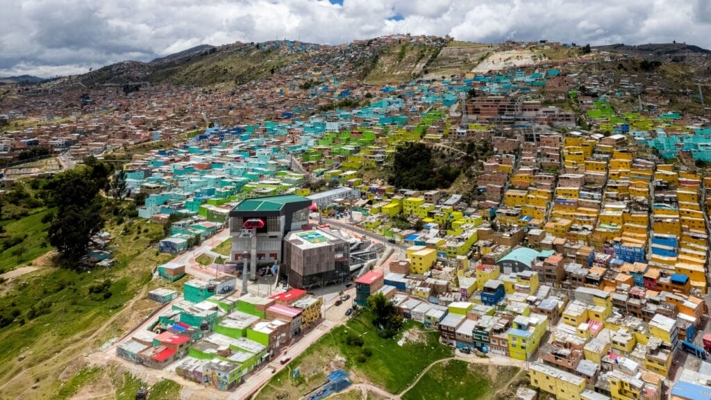
The Manitas Care Block in Ciudad Bolívar opened in 2020, the first of more than 20 new facilities in the city designed to provide services for caregivers. Credit: LLANOFOTOGRAFIA (www.llanofotografia.com).


The underlying idea, initially conceived by Diana Rodríguez Franco, the city’s former secretary for women’s affairs, was to offer much needed relief, respect, and opportunity for the caregivers whose invisible labor keeps the rest of the city running.

Thirty percent of women in Bogotá, 1.2 million people, are full-time caregivers who average 10 hours a day of unpaid labor. Most live in poverty and haven’t had a chance to pursue an education beyond primary school or start a career, denying them the opportunity for economic autonomy.

“That, in Bogotá, seems normal, because of religion, machismo, cultural norms,” López says. “It’s so ingrained in society that this overburden is normal. So [we are] saying, ‘That’s not normal. That is not ethically normal, it’s not socially normal, it cannot be economically normal—it’s actually counterproductive for society that we lose 52 percent of the labor force. So we’re going to change that.’”

Colombia had passed a first-of-its-kind law in 2010 requiring the government to track the economic value of unpaid care work, finding that the care economy represents 20 percent of the nation’s gross domestic product. A later Oxfam study estimated that, if women received even minimum wage for unpaid care work globally, it would amount to $10.8 trillion a year. “We are the basic economic sector that allows all the other economic sectors to function,” López says.

The crisis of the pandemic quickly brought even greater attention to the importance of caregivers, as offices and other formal workplaces shut down, the city’s informal economy ground to a halt, and children stayed home for remote learning. “We went from 900 or 1,000 full-time caregivers to 1.2 million full-time caregivers in four months,” says María-Mercedes Jaramillo, former secretary of planning for Bogotá and a 2024 Loeb Fellow at the Harvard University Graduate School of Design. “So this issue became very tangible.”

Planning and implementing a citywide caregiver support system without an existing model to work from—translating an abstract idea into physical reality—wasn’t easy. But López, Jaramillo, and Franco worked to get the entire city government behind the program. “And when the first Care Block actually got functional,” Jaramillo says, “it really changed, in a very concrete way, the lives of the women who were able to go there.”

Care, There, Everywhere

The Manitas Care Block was the first to open, in the fall of 2020, in Ciudad Bolívar—a low-income neighborhood in the hills of south Bogotá. Laura Mullahy, senior program manager at the Lincoln Institute, says she was “extremely impressed” when she visited the facility this spring as part of a Lincoln Institute course on urban finance and land policy.

“We took the TransMiCable gondola to get there,” Mullahy says, referring to the public cable-car system that connects the steep hillside neighborhoods of Ciudad Bolívar to the city’s bus rapid transit network kilometers below. “Passengers get on and off the gondolas on one floor of the building, and downstairs is the area where government services are offered.”

In addition to professionally provided care and recreational programs for children, elders, and people with disabilities, the free services available to caregivers include medical consultations, legal and psychological counseling, fitness and yoga classes, and educational opportunities. There are even certificate programs for caregivers, intended to formally recognize and elevate the role’s societal status and to train more men in the practice.
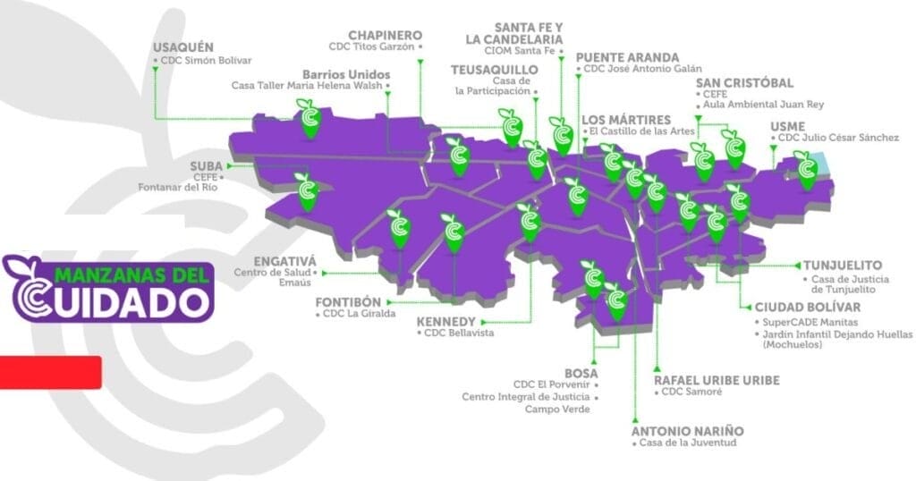
 

Bogotá’s network of Care Blocks is designed to be walkable from most neighborhoods, but Care Buses are available for those who live on the outskirts of the city. Credit: City of Bogotá Secretary for Women’s Affairs.


Available services also include “a community laundry, a computer center, and urban agriculture,” Mullahy says. “The menu of educational offerings is expansive; a few examples are flexible classes to earn high school degrees, job-oriented training, and financial education oriented toward purchasing a home.”

Nearly 50,000 people live in close proximity to the Manitas Care Block, including 5,416 female caregivers—but it’s not just women who benefit. The facility also serves the neighborhood’s 3,838 children under five years old, 3,516 elderly residents, and 2,448 people with disabilities.

Mullahy was also impressed by the employees she spoke to. “They were extremely passionate about their work—and in general, there was a palpable sense of pride in the Care Blocks, both from the staff and the community,” she says. “We were told that vandalism of both the Care Blocks and the associated transportation infrastructure is very low because the community values the system so much.”

Indeed, the Care Blocks have proven immensely popular, even among the politicians who campaigned to succeed López as mayor. And because the Care system is written into the POT, the master plan guiding the city’s urban development through 2035, its impact will outlast any one mayoral term.

All Part of the Plan

As of June, 23 Care Blocks were operating throughout Bogotá. More than 400,000 residents have received free services, including more than 800 women who have completed their high school diploma. The POT includes budgeting and specific plans to establish 22 more locations by 2035. “It’s not cosmetic, it’s really structural,” Jaramillo says. “The Care Blocks are not a marginal thing in the land use plan.”

López uses a more domestic metaphor: “It’s not just the cherry on the cake, it’s actually a strong part of the cake,” she says. “The Care Blocks are just one aspect of a new epistemology of the city, where we have been introducing a different perspective: the perspective of the oppressed. Except that the oppressed are the majority—more than 50 percent of the population.”

Embedding a social program into the master planning process “is very innovative—it’s a brand-new model,” says Anaclaudia Rossbach, the Lincoln Institute’s outgoing director of programs for Latin America and the Caribbean (LAC) and soon-to-be executive director of UN-Habitat. “They are on the frontier of master plans—I think it’s something that the Global South can contribute to the Global North and to other areas.”

It also cemented into place a long-absent feminist perspective on development. “The cities that we have were not planned by, with, and for women,” Rossbach notes. “Incorporating the Care Blocks into the master plan means incorporating a strong gender perspective about the use of space, and it institutionalizes this social policy.”

Rossbach sees hope in the way Bogotá has successfully put abstract principles into practice. “It’s easy to say we need to plan cities so that they work better for women. But the how is more difficult,” she says. “With the case of Bogotá and the Care Blocks, we have a very concrete example that can inspire other cities. And it can also inspire cities to understand that they can be creative in their own way—that they can create something totally different.”


Jon Gorey is a staff writer at the Lincoln Institute of Land Policy.

Lead image:
Caption: Former Bogotá Mayor Claudia López, in light purple, celebrates with caregivers who have completed educational programs offered through the city’s Care Blocks. Credit: City of Bogotá Secretary for Women’s Affairs via Instagram.

Accelerating Sustainable Land Use Planning in African Cities

By Enrique Silva, Chief Program Officer, Lincoln Institute of Land Policy, and Kathy Nothstine, Director of Cities and Societies, Challenge Works, Julio 17, 2024

A recent study from the Lancet found that by the start of the next century, more than half of all births will occur in sub-Saharan Africa. Thanks to higher fertility rates and longer life expectancies, the continent’s population is on track to nearly double to 2.4 billion by 2050, then nearly double again, to 4.2 billion by 2100.

Within Africa, intermediary cities (noncapital cities, typically with a population of 1 million or fewer) are the fastest growing urban places. Between 2022 and 2030, intermediary cities are expected to account for nearly 50 percent of Africa’s overall urban population growth, and this growth will occur largely in cities that currently have fewer than 1 million people. For example, Zinder, the third-largest city in Niger, is expected to more than double its population between 2020 and 2035, growing from about a half-million to over 1 million residents.

The implications of this tremendous growth for people, communities, economies, and the environment are extraordinary, made even more complex by the impacts of climate change and climate migration.

A recent collaboration between the Lincoln Institute of Land Policy and Challenge Works investigated ways to support effective land use planning, infrastructure investments, land-based financing, and disaster resilience in rapidly growing intermediary cities in Africa. We used a mixed-methods approach that synthesizes literature reviews, interviews with urban policy experts and city officials, and specialist workshops.

We explored:

  • the main goals of intermediary cities in Africa when it comes to managing growth;
  • the barriers preventing such cities from using data-driven planning, mapping, and land-based financing tools; and
  • how a challenge prize could accelerate the creation and scaling of such tools.

Below, we summarize some of the things we learned, and how we plan to take the idea of a challenge prize forward.

Growth is not inherently bad—but can have unintended consequences if not managed.

Often, with population growth comes economic opportunity and improved quality of life. More and better jobs, more economic mobility, and better access to health care, education, and sanitation are among the benefits of population growth.

However, we wanted to dig into questions of land use and infrastructure development knowing that:

Land use planning in intermediary cities is critical to creating more sustainable futures.

In speaking with city leaders and experts within government, NGOs, and industry working in this space, we learned that land use planning has different inputs, outputs, and outcomes. When these are integrated, a virtuous cycle can occur:

  • cities can use evidence and insights to inform plans and policies;
  • evidence-based, implementable plans that are created with input from diverse stakeholders are more likely to be enforced and lead to better outcomes; and
  • this increases the level of trust and evidence available to inform new plans and policies.

The enabling ecosystem—which includes elements like institutional capacity to develop and implement plans, political dynamics, human capacity and skills, funding, cultural norms, and more—also plays an important role in creating and implementing land use plans (or conversely, limiting or obstructing progress).

We also learned that the loop can become ineffective for a number of reasons, which are generally attributed to two primary gaps: first, when effective, evidence-based land use plans are not created, due to organizational barriers (things like internal government silos or lack of planning capacity), political and economic barriers (things like political cycles and competition for resources), and technical barriers (such as lack of quality, up-to-date data); and second, when completed land use plans are not implemented, again due to organizational barriers (like complex land tenure), political and economic barriers (limited authority or resource to implement plans), and technical barriers (lack of local buy-in or weak enforcement powers).

Innovation has the potential to both address pain points within those gaps and strengthen the enabling ecosystem.

For example, we’ve identified city-specific use cases to create context-sensitive solutions that use data analytics to better plan for future mobility needs and transport infrastructure, or to better predict climate risk vulnerabilities and therefore inform land use regulations; apply crowdsourced data and citizen-sensing techniques to create and implement inclusive, equitable land use plans; or examine and collate property registration and valuations to bolster municipal finances and the use of land-based financial tools.

At the ecosystem level, creating new tools or adapting tools to the local context can help organizations leapfrog over traditional planning systems and catalyze new practices, and bring together government agencies or organizations that would not normally collaborate.

Tech solutions can help—but need to be paired with institutional enablers.

While our investigations confirmed the exciting potential for data-driven, digital technologies to help city leaders reduce risk and make more informed decisions, we also learned that new data collection and analysis tools are only as good as the planning and implementation processes they inform. Data-driven tools need to be developed in ways that are people-centered, inclusive, and fair, and are ineffective if they aren’t supported by an enabling ecosystem to implement and update effective plans.

Solutions that pair technical innovation with institutional innovation will enable intermediary cities in Africa to pioneer methods to manage growth in ways that are contextually appropriate and don’t yet exist.

A challenge prize can help spark and scale up solutions.

We propose to run an open innovation challenge in partnership with rapidly growing African intermediary cities. Such a challenge would invite innovators to create, test, and scale solutions to manage rapid growth. The challenge structure is based on partnering with cities to create an open call to innovators, oriented around a specific city use case, which will then work closely with city stakeholders to create custom, locally relevant solutions.

The challenge will include these fundamental features:

  • Centering the challenge around opportunities cities want to address. Innovators will respond to challenge statements that reflect the goals cities want to achieve. This is different from, and complementary to, innovation funding approaches that focus on specific technologies or methods.
  • Prioritizing scalable and replicable solutions. Our research revealed a number of promising innovations that are already being piloted and implemented in real-world settings. Despite this, scaling solutions remains a barrier. For instance, innovators who have the right data analytics solution may not have access to the permissions needed to test it in the real world, or the relationships to introduce it in places that need innovation. Local governments may not be prepared to adopt and maintain services. The challenge will be designed to address scaling barriers through seed funding, capacity-building, new business models, and access to customers, investors, and networks.
  • Providing appropriate incentives and support for innovators to experiment and take risks. The outcome-based, stage-gated funding model of an innovation challenge means that innovators can experiment, while cities can benefit from crowding in a variety of ideas and expertise. Having access to both financial and nonfinancial support enables innovators to develop solutions in ways they might not be able to otherwise.
  • Shaping and accelerating innovation in land use planning. By supporting multiple innovators working across multiple use cases and settings, the challenge can accelerate progress in the field of land use planning, as well as steer innovation in a direction more attuned to the needs of rapidly growing cities in low- and middle-income countries.

The time is now.

Africa is both the cradle of civilization and the world’s youngest continent, with half the population under the age of 19. The continent is also facing critical risks related to climate change and associated implications to disaster resilience, food and water security, energy supplies, and more. To ensure that future city growth in Africa is inclusive, equitable, sustainable, and resilient to changing conditions, we urgently need to take action now to accelerate and scale new models to manage growth. Our next steps are to assemble the partners to implement the next stage of the challenge. If you are interested in contributing, get in touch!

With sincere thanks to Stefan Chavez-Norgaard, Teodora Chis, Astrid Haas, Peter Oborn, and the many policy experts, development practitioners, city officials, tech innovators, and others who provided their insights and experiences to shape this program.


Lead image: City market street in Lagos, Nigeria, West Africa. Credit: peeterv via iStock/Getty Images Plus.

Curso

Economía urbana: ¿Cómo planificar y gestionar mejor la ciudad?

Noviembre 25, 2024 - Noviembre 29, 2024

Vitacura, Santiago de Chile, Chile

Offered in español


Este curso presencial dirigido a profesionales del ámbito de la planificación y la gestión urbana abarcará diversos temas, entre los que se incluyen la ciudad y su base económica en el sistema urbano, los fundamentos económicos de la formación de precios y usos del suelo, la regulación de usos del suelo y sus impactos, la recuperación de plusvalías, entre otros. 

El curso es organizado por la Comisión Económica para América Latina (CEPAL), con el apoyo del Ministerio de Vivienda y Urbanismo de Chile, la Universidad Torcuato di Tella, la Universidad de Costa Rica, la Fundación Getulio Vargas – Ciudades, y el Instituto Lincoln de Políticas de Suelo.


Detalles

Date
Noviembre 25, 2024 - Noviembre 29, 2024
Time
9:00 a.m. - 6:00 p.m. (-03, UTC-3)
Registration Period
Julio 1, 2024 - Agosto 15, 2024
Location
Comisión Económica para América Latina y el Caribe (CEPAL)
Av. Dag Hammarskjöld 3477
Vitacura, Santiago de Chile, Chile
Idioma
español
Educational Credit Type
Lincoln Institute certificate

Registrar

Registration ends on August 15, 2024 at 11:59 PM.


Keywords

desarrollo económico, planificación, finanzas públicas

Eventos

City Club of Cleveland 2024 Summer Outdoor Series Featuring George “Mac” McCarthy

Julio 31, 2024 | 12:00 p.m. - 1:00 p.m. (EDT, UTC-4)

Cleveland, OH United States

Offered in inglés

Lincoln Institute of Land Policy President and CEO George W. McCarthy and President and CEO of The Port of Greater Cincinnati Development Authority Laura Brunner will participate in a forum on July 31 at 12 p.m. EDT as part of the City Club of Cleveland’s 2024 Outdoor Summer Series. They will discuss Who Owns America—an innovative geospatial mapping project helping communities like Cincinnati preserve its affordable housing stock. The talk will  will cover challenges and opportunities to expand affordable housing, and the critical role of precise data in informing policymaking.      

This free event will be held at the Playhouse Square Plaza and will also be livestreamed on the City Club of Cleveland’s website. 


Detalles

Date
Julio 31, 2024
Time
12:00 p.m. - 1:00 p.m. (EDT, UTC-4)
Registration Period
Julio 8, 2024 - Julio 31, 2024
Location
The City Club of Cleveland
Playhouse Square Plaza
Corner of East 14th Street and Euclid Avenue
Cleveland, OH United States
Idioma
inglés

Registrar

Registration ends on July 31, 2024 12:00 PM.


Keywords

vivienda

Oportunidades de becas

Premio Lincoln al periodismo sobre políticas urbanas, desarrollo sostenible y cambio climático 2024

Submission Deadline: August 9, 2024 at 11:59 PM

El Lincoln Institute of Land Policy convoca a periodistas de toda América Latina a participar del concurso “Premio Lincoln al periodismo sobre políticas urbanas, desarrollo sostenible y cambio climático”, dirigido a estimular trabajos periodísticos de investigación y divulgación que cubran temas relacionados con políticas de suelo y desarrollo urbano sostenible. El premio está dedicado a la memoria de Tim Lopes, periodista brasileño asesinado mientras hacía investigación para un reportaje sobre las favelas de Rio de Janeiro.  

Convocamos a periodistas de toda América Latina a participar de este concurso. Recibimos postulaciones para el premio hasta el 9 de agosto de 2024. Para ver detalles sobre la convocatoria vea el botón “Guía/Guidelines” o el archivo a continuación titulado “Guía/Guidelines“. 


Detalles

Submission Deadline
August 9, 2024 at 11:59 PM
Enlaces relacionados

Keywords

mitigación climática, vivienda, planificación, pobreza, agua

A man looks at a flooded area from a helicopter

Recovery and Resilience: New Research on Exploratory Scenario Planning for Disasters

By Jon Gorey, Mayo 9, 2024

When heavy rains unload on Beaumont, Texas—which is to say, pretty often, in this small Gulf Coast city 80 miles east of Houston—flash flooding can turn the underpasses beneath train tracks and bridges into unpassable, sewage-laden lakes, as pump systems get overwhelmed.

It’s a citywide issue, but it’s especially problematic in Beaumont’s historic South End. Ringed on three sides by heavy industrial facilities—including a 2,400-acre ExxonMobil refinery and chemical plant, the 100-acre Port of Beaumont, and a facility that holds thousands of rail cars—such inundation can essentially leave residents and workers stranded in the neighborhood, with no way out.

“We’ve always had an issue where our underpasses flood, and so we’re trapped without access to emergency medical facilities,” says Christopher Jones, founder and director of the South End Charlton-Pollard Greater Historic Community Association. “During events like Harvey or Imelda, we’re trapped within that industrial horseshoe.”

The prospect of getting stranded by an everyday downpour creates anxiety for residents, as well as tangible health hazards. “Our streets fill up with sewer and rainwater, and there’s no cleanup that happens afterward, whether it’s from the city or the state of Texas,” Jones says. “Then that sewage matter dries up and becomes an airborne pathogen that we breathe,” along with other pollutants, such as limestone dust, sulfur, and petrochemical byproducts produced or transported nearby. Indeed, between the dangerous chemicals in nearby rail cars and refineries, its hurricane-prone location, and the increasing frequency of extreme heat waves, flooded roadways are hardly the only disaster-related risk facing the Charlton-Pollard neighborhood.

So when Jones heard about a request for proposals issued by the Lincoln Institute’s Consortium for Scenario Planning (CSP), he proposed a series of exploratory scenario planning workshops that would gather ideas and input from community members, city officials, emergency agencies, and local businesses, to formulate and prioritize resilience strategies.

The review committee found the Beaumont proposal unique and compelling for a couple of different reasons, says Heather Hannon, associate director of planning practice and scenario planning at the Lincoln Institute. “It’s the first community organization awarded through this process,” Hannon says, as opposed to a municipal department, planning agency, or research team. What’s more, the proposal specifically focuses on the “dual-threat landscape” of both natural and man-made disasters.

The neighborhood is well aware of the “escalating risks posed by climate change, industrial accidents, and other man-made hazards,” Jones explained in his proposal. “Our community’s proximity to a dense concentration of industrial operations elevates the risk of chemical spills, industrial explosions, and air quality emergencies, in addition to natural disasters like hurricanes, floods, and severe weather events.”

Jones says the old housing stock in his neighborhood isn’t very suitable for sheltering in place, whether it’s during a storm or a chemical spill. “My neighborhood dates back to the 1800s, and many of the homes here are, if not the same age as ExxonMobil, a little bit older.” Many of those homes lack the kind of weatherization upgrades—insulation, storm windows, air sealing—that would better protect them from storms and air quality issues.

“I definitely want my neighbors to have the opportunity to not only weatherize their homes, but to be able to seek safety and shelter inside of their homes if there’s anything like an explosion from ExxonMobil,” Jones says. When a series of chemical explosions rocked a TPC plant in nearby Port Neches in 2019, “We felt it—we smelled it,” Jones says.

“So if we were to experience something like, God forbid, a big waste of benzene, everybody here is [in serious trouble], because they don’t have the knowledge or adequate facilities to shelter in place,” he adds. “And that includes schools that are in our area, businesses in our neighborhood, elders . . . that, to me, is our starting point for our resilience.”

Smoke from an explosion at a chemical refinery in Texas
Aftermath of a series of explosions at a TPC Group chemical plant in Port Neches, Texas, in 2019. The initial blast was felt up to 30 miles away, and the explosions caused $153 million in offsite property damage. Credit: US Chemical Safety and Hazard Investigation Board.

The South End Charlton-Pollard project is one of five that the Consortium for Scenario Planning has chosen to support in response to the RFP. From Colombia to Canada, each project will design exploratory scenario planning workshops focused on disaster recovery and resilience. The awardees will have the opportunity to present and describe their work in early 2025 at the annual Consortium for Scenario Planning conference.

Awardees are tasked with designing workshops that use exploratory scenario planning (XSP) to help members of their community—which could be a neighborhood, city, or entire region—explore disaster recovery and resilience strategies. Applicants were encouraged to address both one-off disasters as well as those that are part of a larger cycle of “cascading hazards, where the effects of one disaster bleed into or cause another”—such as droughts that contribute to wildfires or landslides, or floods that destroy homes and then trigger sanitation crises.

In addition to the XSP workshops that the South End Charlton-Pollard Greater Historic Community Association will design and conduct in Beaumont, CSP selected four other proposals to support:

  • Building off its recent completion of a participatory climate risk assessment, the Rural Municipality of Piney in Manitoba, Canada, will use a seven-step XSP framework to develop workshops and educational resources to help the region better prepare for a spectrum of disasters, particularly wildfires.
  • Casa del Sur/Encuentro in Santa Fe, Argentina, will focus on building resiliency awareness among vulnerable citizens, who have been affected by both record floods and record lows of the Paraná River, urban heat, and fires in the past two decades.
  • A team from the Virginia Institute of Marine Science (VIMS) at the College of William and Mary in Williamsburg, Virginia, will develop a framework for rural communities to plan for and adapt to sea level rise flooding and increased storm flooding impacts, using rural Virginia as the target audience and a special emphasis on nature-based features.
  • A team from the Urban Mapping Agency, BuroDAP, and Universidad del Rosario in Bogotá, Colombia, will conduct XSP workshops with a special focus on vulnerable communities and informal settlements facing flood risk in the urban peripheries of two major cities—Policarpa in Cartagena, and the Tunjuelo River floodplain in Bogotá.

All five projects, scheduled to be completed by May 2025, were selected as part of an annual RFP process managed by the Consortium for Scenario Planning. Past projects have focused on housing affordability (2023), changing food systems (2022), climate strategies (2021), and equity and low-growth scenarios (2020).

To learn more about all Lincoln Institute RFPs, fellowships, and research opportunities, visit the research and data section of our website.


Jon Gorey is staff writer at the Lincoln Institute of Land Policy.

Lead image: A member of the Coast Guard inspects flooding in Beaumont, Texas, as part of a search and rescue mission after Hurricane Harvey. Credit: Petty Officer 3rd Class Brandon Giles/US Coast Guard/US Department of Defense.