Just over a decade ago, Katie Banks Hone learned that monarch butterfly populations were plummeting, putting the species at risk of extinction this century.
Around the same time, Tony Frisk saw a documentary about honey bee colony collapse disorder that left him unnerved.
Hone and Frisk each felt compelled to take some kind of action on nature’s behalf—to do something. So they each started where they could: at home, Hone north of Boston, Frisk in suburban Minneapolis.
Both replaced large portions of their suburban lawns with native plants and shrubs that better support and nourish butterflies, bees, caterpillars, and birds. Now their yards hold dozens of host plants—species that native insects eat or lay eggs upon—and hum with wildlife.
“When I first moved in, it was a barren landscape,” Frisk says of his suburban Minneapolis yard, with few birds save for the occasional American robin. “But over the course of the last 10 years, I see birds that I’ve never seen before.” Not to mention butterflies like the charismatic monarch, whose familiar beauty has made it something of an ambassador for threatened North American pollinators.
“We’re a third of an acre, we’re not a very big property,” says Hone. “But we have somewhere between 80 and 90 species of native plants that I’ve added, and every one is a nectar source or a host plant for an insect. And the amount of wildlife that comes into our yard is just astounding,” she says, including a family of screech owls.
Strangers living over a thousand miles apart, Hone and Frisk are nonetheless connected by a growing national movement—one that includes homeowners and community groups but also schools and municipal parks departments—to restore native wildlife habitat in developed areas.
By planting native pollinator gardens and Miyawaki microforests, whether in front yards, schoolyards, or vacant lots, individuals and communities across the country are inviting nature back into the cities and towns from which it was once expelled.
The ‘Homegrown’ National Park
It was a late August morning three or four years ago when Frisk realized the full impact of the habitat he’s created. Among the native flowers he had planted were the monarch butterfly’s only host plant, milkweed, and some of its favored fall nectar sources, such as meadow blazing star. “I went outside and I counted at least 25 monarch butterflies in my backyard; it was magical,” Frisk says. “That was the point I realized, ‘Oh my gosh, this is significant.’ If it’s just me doing this, could you imagine if other people would do this, and how much more of a benefit that would have overall?”
That’s the idea behind Homegrown National Park (HNP), an initiative cofounded by Doug Tallamy, University of Delaware professor of entomology and bestselling author of Nature’s Best Hope: A New Approach to Conservation That Starts in Your Yard.
American homeowners are prodigious grass farmers, using water, fertilizer, and herbicides to cultivate more than 40 million acres of lawn, according to a 2005 NASA-led study. That’s more than any other irrigated crop. That’s more than any other irrigated crop. While turfgrass is great for backyard barbecues and wiffleball games, it’s a barren landscape as far as local wildlife is concerned. Tallamy realized that if US homeowners added native trees, shrubs, or flowers to even half the space we devote to lawns, that effort would restore more acres of wildlife habitat than exists in most of our national parks combined.
“The idea is that you go on our biodiversity map and put in where you live, and the area of your property that you’re going to start to be a good steward of,” explains Tallamy, who is quick to credit HNP cofounder Michelle Alfandari for bringing the idea to life. With more than 57,000 registered sites now comprising over 106,000 acres, the Homegrown National Park is already collectively larger than Maine’s Acadia National Park and Utah’s Bryce Canyon National Park put together.
Still, Tallamy would like to see millions of pocket prairies and pollinator gardens on that map, not just thousands, given the rate at which species are going extinct. “Humans are part of nature, it is essential to our survival,” Tallamy says. “[Nature] is not optional, which means everybody has a responsibility in supporting it.”
Meanwhile, federal support for wildlife and land conservation is waning: The Trump administration in March issued an executive order encouraging federal agencies to bypass environmental regulations in order to fast-track logging and timber production on millions of acres of national forests and other public lands, for example. That puts even greater urgency on protecting ecosystems and wildlife habitat at the local or even household level.
Curbing a Crisis, at the Curb
Climate change is the ecological emergency of our time, but the parallel crisis of biodiversity loss gets less attention. One million—or one in eight—species are now at risk of extinction around the world. North America alone has lost a staggering 2.9 billion birds since 1970.
And the insects that form the foundation of the natural food web, including the bees and butterflies that pollinate about a third of the world’s farmed food, are in serious trouble. “We’ve lost 75 percent of the insects on the planet already,” Tallamy says, citing data from a 2017 study in Germany.
Insects don’t merely pollinate plants. They also turn leaves into protein for baby birds and other wildlife. More than 90 percent of land-based North American birds raise their young on the soft protein of insects, as opposed to seeds, nuts, or berries. Chickadee parents, for example, take turns catching upwards of 370 caterpillars a day to feed a nest of newborns, Tallamy says; it takes more than 6,000 caterpillars to feed one clutch of baby chickadees for the two and a half weeks before they fledge.
So if we want birds, we need insects. A number of things threaten insect populations, including habitat loss, increased use and potency of pesticides, and human-caused climate change. But a less acknowledged factor—and one that individuals and communities can help counteract themselves, right now—is the loss of native plants on which insects feed and breed.
Our pollinators and other insects coevolved with native plants over thousands of years. As plants developed defenses—like the toxic compound found in milkweed, which keeps most critters from eating it—insects adapted through specialization, evolving to tolerate the unique defenses of just one or two plant species. Some 69 percent of our caterpillars can only develop on a single family of host plant—such as the monarch, who can only survive on milkweed.
If that host plant doesn’t exist, then neither will the caterpillars who rely upon it. And over the past century, as wild prairies and forests were converted for agriculture or urban development, and as homeowners and landscapers grew enamored with showy shrubs and ornamental trees imported from other continents, insect-nourishing native plants have vanished or been replaced by species that provide little or no ecological value to local wildlife.
Many of the shrubs and street trees imported from other continents to beautify our landscapes—from tidy English yews and boxwoods to blooming Callery pear trees—may offer humans some combination of shade, attractive foliage or flowers, carbon absorption, or water retention. But they offer precious little to native insects.
Tallamy conducted a caterpillar count several years ago on the lower branches of a “Bradford” Callery pear tree (native to East Asia, it’s invasive in some states) and on a neighboring oak tree. The Callery pear had four caterpillars, all the same species, while the native oak had more than 400 caterpillars, with 15 different species represented.
The oak tree was at no risk from all the leaf-nibbling caterpillars Tallamy found; they would soon become bird food or butterflies. That’s why planting native trees, shrubs, and flowers in our yards is a simple, tangible way for anyone to protect and restore natural ecosystems.
“We have vilified insects, even though they are ‘the little things that run the world,’ to quote E.O. Wilson,” Tallamy says. But without insects, we don’t have birds, flowers, or food to feed the world’s growing population. Without insects, we don’t have life.
Conservation Through Conversion
While most native plants support wildlife far better than introduced species, Tallamy says there are some “keystone species” in each region—including oaks, cherry trees, goldenrods, and black-eyed Susans—that go above and beyond in that regard. Even apartment dwellers with a small balcony or front stoop can create a productive pit stop for pollinators by planting pots of, say, Tahoka daisy in Phoenix, or Maryland golden aster in Atlanta.
For homeowners who have a yard but not the time or interest for gardening, the simplest way to convert a lawn into a thriving ecosystem is to plant an oak tree. “If you think of a plant as a bird feeder, which is exactly what it is, then in most regions, the oak makes the most food,” Tallamy writes in Nature’s Best Hope. Resist raking and let the fallen leaves be, as they provide a critical “soft landing” zone for caterpillars and other overwintering insects. (And it perhaps goes without saying, but spraying insecticide does no favors for beneficial insects. Organic or not, if a yard spray is strong enough to kill mosquitoes, Tallamy says, it will kill other insects, too.)
For homeowners ready to take things a step farther, converting portions of lawn into pollinator habitat can have powerful ecological impacts.
When Hone and her husband first bought their house along the Ipswich River, the yard was full of nonnative and invasive species, and 4,000 square feet of plastic sheeting was buried under the soil, hastening water runoff into the river. With the help of a matching “Slow the Flow” grant from a local watershed group, Hone pulled up the plastic and removed invasive plants like barberry, and then started building rain gardens and planting native shrubs and flowers.
As the years passed, Hone, a former aquarium biologist, devoted more time and lawn space to native plants, and gained a local following as the Monarch Gardener. She tries to keep her street-facing gardens somewhat tidy but really allows nature to take its course out back.
“I’ve let it kind of go wild along the river, and it’s all white wood aster ,” she says. “My husband and I went out on a canoe ride last year, and we came up the stairs from the river, and he just said, ‘Whoa.’ The whole hillside was shimmering with bees, it was amazing.”
[Caption: For an early April bloom, when critters emerge hungry, Hone says, “I love spicebush. It’s a host for the spicebush swallowtail caterpillar, which kind of looks like a Pokémon character.”]
To convert a portion of lawn into a pollinator garden, you generally have to get rid of the grass first—which isn’t as easy as it sounds. Some tried-and-true methods include:
- Digging it up: Using a garden spade or sod cutter to remove the top few inches of sod, and then replacing it with compost, soil, or mulch, is hard work, but allows for immediate planting.
- Solarization: Staking a sheet of clear or black plastic over the lawn in summer will trap the sun’s heat and kill the grass and seeds beneath it after a few months. Once the grass is completely cooked, planting can commence in the fall or the following spring.
- The ‘lasagna’ method: Another way to kill grass is to cover it with wet cardboard or layers of builder’s paper and newspaper, and then cover it with a layer of compost or mulch, keeping it wet. The paper will block sunlight to smother the grass, and naturally degrade over time. Eager gardeners can plant right away by cutting holes through the paper or cardboard, and weeding any grass that manages to sneak through.
By now, Frisk has converted most of his lawn into gardens, and says it’s both easier and less expensive to care for his plants than it would be to maintain a manicured lawn all summer. “I’ve taken the lawn down to a third of what it was, and so now I can get away with just a battery-operated mower, so it’s a different level of maintenance,” he says.
That’s the thing about native plants: They generally require very little maintenance once they’re established. Imported plant species, including most turfgrasses, often demand extra resources, like water and fertilizer, to stay healthy and happy here in the US. In the Los Angeles area, for example, a 1,500-square-foot lawn requires about 43,000 gallons of water a year , while drought-tolerant native plants will generally ask for no more than Mother Nature provides.
Plants native to an area love the soil just the way it is. Planted in the right spot, they won’t find a yard too acidic or too basic, too wet or too dry, too sunny or too shady; those same conditions are the ones they’ve specifically evolved to thrive in over thousands of years.
Conversion Through Conversation
By daring to plant native flowers in place of a manicured, irrigated lawn, Frisk isn’t just creating precious wildlife habitat and saving water. He’s also inviting neighbors and visitors to reimagine what a well-tended suburban landscape looks like.
In Nature’s Best Hope, Tallamy explores the power of social norms, and how caring for one’s lawn has become a kind of cultural shorthand we use to tell neighbors that we’re trustworthy, upstanding people who take pride in our community. “The people who take care of their lawns are considered good citizens, because they’re conforming to cultural norms,” Tallamy says. “What we have to do is change the cultural norms.”
Frisk worried about how his garden would be received on his street of suburban lawn scapes, but his neighbors seem to love the sight of purple coneflowers, shrubby St. Johnswort, bright orange butterfly milkweed, and other flowers and native grasses in his front yard. “There’s a group home a few houses down, and an assisted living place two blocks away, and people will walk all the way down just to look at my gardens,” he says. When strangers ring his doorbell to ask him questions or gardening advice, he obliges with an impromptu tour (incidentally, the kind of material, social interaction that is crucial to shifting people’s perceptions and behaviors). “Last year, I had a lady with her young children come by and ask if she could do their spring photos in my garden.”
Like Hone, Frisk keeps his street-facing garden tidier than the back. “My backyard, I can go a little bit more crazy because it’s fenced and it’s mine to see,” he says. “Sometimes I call my yard a mullet—it’s nice in the front, but wild in the back.”
[Caption: Frisk’s colorful front yard contrasts with the uniform lawns of his neighbors. Small “cues of care,” such as a stone path or mown strip of grass, can help signal that a native garden is intentional.]
While it’s fine to leave a few non-native flowers and trees in your landscape, Tallamy says, “there’s no room for compromise with invasives, because they don’t stay where you plant them.” Invasive species—kudzu, wisteria, glossy buckthorn, tree of heaven, Asiatic bittersweet, black swallow wort, and Japanese barberry among them—spread vigorously and easily jump from yard to yard until they reach protected areas, where they wreak havoc on ecosystems, growing and spreading so aggressively that they smother or outcompete the native plants that insects need to live. “They’re ecological tumors—they just keep spreading,” Tallamy says.
State and Local Action
Pennsylvania recently introduced a program that rewards homeowners with free native tree saplings if they remove invasive species from their yards. The Keystone State also provides funding to encourage homeowners and businesses to replace their lawns with native meadows.
Minnesota has a similar program, while California offers a cash rebate for every square foot of lawn removed to improve water conservation, Tallamy says. “It’s not that you get rich doing that, it’s that it makes it socially acceptable,” he says.
But even in the absence of statewide programs, communities can encourage residents and businesses to contribute to wildlife conservation by planting native landscapes, says Jim Levitt, director of the International Land Conservation Network (ILCN) at the Lincoln Institute of Land Policy.
Communities should discourage homeowner associations from mandating uniform green lawns, for example. They can also recognize and reward homeowners who keep exemplary gardens, the way historical associations hold neighborhood tours or give awards for faithful restorations. “Encourage displays of natural habitat, and recognize them with awards,” Levitt says.
It’s not just homeowners who can create wildlife habitat on their properties. Businesses and corporate office parks, schools, and other public buildings—many of them have swaths of largely unused lawn or pavement that could instead host beneficial tree and plant species. For example, a lot of suburban schools are ringed by decorative, empty lawns that are neither play areas nor ballfields, “that could be more heavily planted with trees,” Tallamy says.
“Exemplify what you’re trying to encourage by planting municipal open space, when appropriate, with native species,” Levitt suggests. “That isn’t to say that you should put trees in the middle of baseball fields. But you should show how it’s both beautiful and economical to do it.”
Tiny Forests, Big Impacts
In 2021, Cambridge, Massachusetts, did just that, planting the first Miyawaki forest in the Northeast. Based on techniques researched and developed by Japanese botanist Akira Miyawaki as he sought to reintroduce native wilderness to degraded and developed landscapes, these tiny forests are so densely planted with native species that they encourage rapid growth, typically attaining self-sufficiency after three to five years.
In Cambridge, many of the trees—which were planted as bare-root stems just over three years ago—are now more than 15 feet tall, and one volunteer who has tracked the forest’s growth says it’s so dense with foliage in summertime that the center appears “pitch black.”
Deliberately planted with multiple layers of native species, from shade-loving ground cover to overstory trees, these tiny or pocket forests not only replicate native habitat. The thick greenery helps to counter the urban heat island effect, improve air quality, and reduce stormwater runoff.
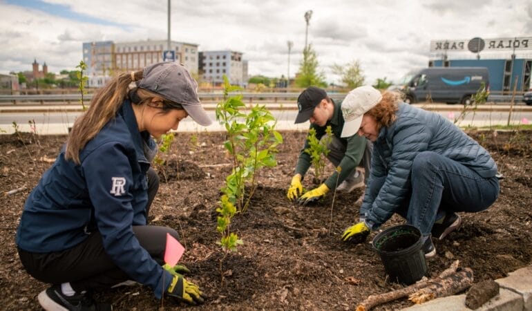
Cambridge has since planted two more miniforests, and other Massachusetts communities followed, including Brookline, Natick, Somerville, and Ayer. In 2024, the city of Worcester used a matching grant from the state’s Municipal Vulnerability Preparedness (MVP) program to plant two Miyawaki forests—one of which replaced over 6,000 square feet of pavement in a downtown parking lot.
The forests “addressed so many of the goals and action items in our [Green Worcester] plan,” says Luba Zhaurova, director of projects at the city’s department of sustainability and resilience.
After receiving the state grant in mid-September, the city had nine months to identify appropriate sites and complete the planting. The city first looked at municipally owned properties, screening potential sites against heat island maps, Zhaurova says. After narrowing down the list to six schools and municipal buildings, they went on site visits with BSC Group, the consultancy managing the project, she says. “It was this bitter cold January day, so trying to imagine this beautiful, thriving forest was a bit of a mental exercise,” she says.
The downtown public library emerged as the most suitable site: It had a large and underused parking lot, located in a heavily paved neighborhood especially vulnerable to extreme heat. Pursuing the suggestion of a community member, the city opted to locate its second miniforest at Plumley Village, a privately owned, low-income housing development. That required a bit of extra negotiation with the owners of the development, says Zhaurova, who notes that the city agreed to cover the added expense of a fence in addition to the other project costs.
A Faster Forest
A vacant lot left fallow will still grow plants or trees. So why go through all this trouble to carefully plant desired native species? The ecological goal is “expedited succession,” says Caseylee Bastien, senior landscape architect and ecologist at BSC Group.
It could take decades for an empty lot to develop into a healthy forest, but some targeted intervention can hasten that transition. “It would take thousands of years for some of these species to find these locations, if at all, on their own,” he says. “So having sped things up in the wrong direction, we can speed things up in the right direction.”
One of the key concepts of the Miyawaki method is replicating the ecological processes that take place in an old-growth forest. So in addition to planting a variety of native trees and shrubs, a new forest should also get a “duff” transplant—that is, some of the leaf litter on the floor of an existing woodland—to introduce the fungi, protozoa, and other microorganisms that break down wood, leaves, and minerals into healthy soil.
Miyawaki forests tend to elicit community support and volunteer interest, so Bastien says this step presents a unique educational opportunity to help the public better understand forests in a tangible way. At the outset of a project, he’ll sometimes lead volunteers into nearby woods to forage for healthy soil, seeds, or fungi with which to inoculate a new urban forest.
“Getting people to collect stump soil that’s been turned over when a tree fell, all that good rot, that is the perfect set of bacteria and fungi that I want to bring to a new forest to educate it about what it should grow into,” he says. “And then people see that, ‘Ahh, the forest is in the soil.’”
He also takes the opportunity to share stories about a plant’s special properties. “We’ll get to an oak, and I’ll say how, mythologically, this is the king of trees, and these young oak warriors are marcescent—so they would hold their leaves into winter and shake their dry leaves in the face of darkness and say, ‘We will not go quietly into the night,’” Bastien says.
“Now, in the landscape, that oak is central to a lot of different species, and we’ve sort of always understood this as a people. But that marcescent piece is actually a technique for them—it’s a protection against browsing deer,” Bastien explains. “Because in the springtime, the buds are packed with sugar to protect the cells from frost, and that also makes them extra delicious. So if the young ones that are down low are holding onto their leaves, a deer gets a mouthful of dry fiber instead of a sweet, tasty flower bud.” Thus, the oak will likely live to host hundreds of larval pollinators as birds and butterflies use its leaves to make protein, feeding the whole ecosystem.
This kind of outing can help sustain volunteer interest as well—which can lag after the initial excitement wears off. While over 100 volunteers turned out to help the city of Worcester plant its first Miyawaki forest, Zhourova says it’s harder to recruit volunteers for follow-up maintenance. “People are a lot more excited about planting than weeding, and weeding in the first couple of years is very important,” she says.
A Miyawaki forest is intended to reach self-sufficiency in three to five years, at which point natural processes take over: Upper-story trees cast dense shade that inhibits weed growth, and fallen leaves nourish the soil, which absorbs and retains carbon and rainfall.
In addition to vertical layers, the forest changes from edge to center as well. “We think about buffer and refuge, so making sure we’ve got some of those climax species that are exceptionally high value—they’re harder to find, they’re slower growing, they need certain conditions—and then filling in around them with rutteral species, or early succession species,” Bastien says. “Rutteral is the German word for rubble, so these are plants that come out of the rubble, plants that thrive on disturbed sites—they’re weak, they’re cheap, they’re fast, but they create a lot of biomass really quickly,” he explains.
Species like birches, cottonwood poplars, and tulip trees grow quickly, retaining humidity to help the rest of the young forest. “One of the benefits we’ve seen with the Miyawaki method is more drought resistance,” Bastien says, “because they’ve got that cumulative humidity and airspace by being compact—that’s its secret benefit.”
While some of the hype around Miyawaki forests may be overblown, Bastien says—particularly their potential for sequestering carbon more quickly—he sees them as an important way to invite nature back into cities. “The urban environment can still be good bird and pollinator habitat for a core group of species that are very important for maintaining ecological balance,” he says.
Every Square Yard Counts
If all of this sounds expensive, it can be—but it doesn’t have to be. After all, seeds are cheap, native plants are eager to grow in your soil without fertilizer or irrigation, and a squirrel will plant an oak tree for free. The choice for homeowners and cities alike often comes down to spending money or time. Bigger, more established plants cost more but provide instant gratification.
Still, Tallamy says, a tiny seedling can catch up to a 15-foot, balled-in-burlap tree pretty quickly. Since the roots of the larger sapling have been severed for transport, the tree will need to spend some time regrowing them, limiting its above-ground growth for several years. “They have to sit there and rebuild that root mass,” Tallamy says. “If I plant an acorn the same day—and I have done this—in 10 years, that tree from the acorn will be bigger and much healthier than the one that I spent a lot of money on. But it doesn’t happen on day one.”
[Caption: This northern red oak, which began as a 6-inch sapling in 2012—presumably planted by a squirrel—has grown 25 feet in 12 years.]
Frisk is now reaping the rewards of his earlier efforts, and each year must remind himself not to go overboard with it. “Once you start to see your hard work pay off, when you see different bird species and different insects arrive, that’s where it also gets a little dangerous,” he jokes. “Because you look at all the monarch butterflies showing up now, and then you want to do more, and you want to do more.”
The first year Frisk started gardening, he converted a 60-foot by 30-foot section of lawn—and injured his back. He advises budding gardeners to take it slower than he did. “Start small, don’t burn yourself out. Because if it becomes a chore, it’s not going to be an enjoyable hobby.”
There are also gradients to any natural restoration project, Bastien notes. While converting a parking lot to a healthy Miyawaki forest takes “a big municipal effort, long-term plans, and some expertise,” there are now enough guides available online that an individual or community group could probably start a small microforest “with $500 and a grudge,” Bastien jokes.
“I’m happy to see people putting in the tutoring to raise a D-grade landscape to a C,” he says, noting that “better doesn’t have to mean perfect.” After all, the goal of both the Homegrown National Park initiative and Miyawaki forests is to let nature takes its messy, magnificent course.
As Bastien puts it, “Perfect is an unnatural idea.”
[Caption: This patch of native plants bordering Hone’s suburban street includes oxeye sunflower, purple coneflower, bee balm, sweet Joe Pye weed, and bugbane in bloom.]