Past Projects
High-Resolution Mapping
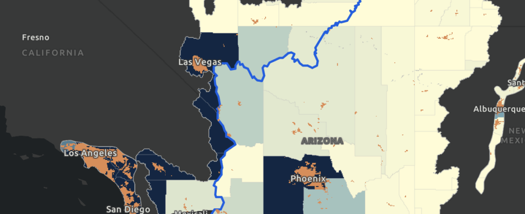
We collaborated with the Conservation Innovation Center of Maryland’s Chesapeake Conservancy on precise high-resolution mapping, down to one square meter, to model how water moves across the landscape and impacts local and regional land use. This collaboration resulted in floodplain mapping for green infrastructure for the Pima County Flood Control District in Arizona; regional land use land cover mapping for the Denver Regional Council of Governments in Colorado; an ArcGIS StoryMap, Swimming Upstream, of the Endangered Fish Recovery Program for the Colorado Water Conservation Board; and ecosystem service opportunities near Bears Ears National Monument, Utah, in collaboration with the Grand Canyon Trust. These high-resolution mapping products provide organizations with information critical to identifying priorities at the parcel scale, such as green infrastructure placement. This work is invaluable to land and water managers, local planners, and policymakers whose decisions impact the economy and quality of life in their communities.
Colorado Water and Land Use Planning Alliance
The Babbitt Center provided seed funding for a position within the Colorado Department of Local Affairs to spearhead this group and still collaborates with various alliance members. The alliance is a grassroots group of multidisciplinary partners comprising state agencies, local governments, NGOs, and researchers that help local communities effectively incorporate water into comprehensive planning. The alliance’s work supports priorities in the Colorado Water Plan, one of which is to help achieve a Colorado Water Plan goal: by 2025, 75 percent of Coloradans will live in communities that have incorporated water-saving actions into land use planning.
Water, Land, and Growth in Central California
The San Joaquin Valley is one of the fastest growing regions of California, and the state’s Sustainable Groundwater Management Act (SGMA) is likely to have far-reaching implications on communities’ future growth there. The valley’s urban, suburban, and rural communities bear the brunt of new growth in the region yet may not have renewable water supplies to meet future demands. The Babbitt Center worked with the Public Policy Institute of California’s Water Policy Center to understand the implications of California’s SGMA on urban, suburban, and rural communities in the San Joaquin Valley.
2019 Journalists Forum
In partnership with the Walton Family Foundation, the Gates Family Foundation, and the Arizona State University Cronkite School of Journalism, we hosted a Journalists Forum that explored the history, science, and politics of water management, and delved into innovative policies and practices that help forge a sustainable water future.
Presentations, session video clips, and the agenda from the forum are hosted online.
View Forum MaterialsEnhance Colorado’s Water Efficiency Plans
We worked with the Getches-Wilkinson Center for Natural Resources, Energy, and the Environment at the University of Colorado Law School to write Best Practices for Implementing Water Conservation and Demand Management Through Land Use Planning Efforts. This document, adopted by the Colorado Water Conservation Board in January 2019, updated the State of Colorado’s water efficiency plan guidance to include land use practices that foster water savings.
Lessons from the Colorado River: Climate, Land, and Drought
Previous US Interior Secretary and Arizona Governor Bruce Babbitt and former US Bureau of Reclamation Commissioner Brenda Burman discussed the future of the Colorado River. Moderated by Babbitt Center for Land and Water Policy Director Jim Holway, this 75th Anniversary Lincoln Institute Dialogue covered Colorado River conditions; current and emerging policy challenges; lessons on international and interstate river management; and how local governments, water utilities, land managers, and Native American nations can promote water sustainability.
View the Recording of the Dialogue and Related ResourcesTrouble in Paradise: Arizona’s Distressed Golf Courses
The Babbitt Center catalogued Arizona’s golf courses, detailing information on location, state of operations, relation to nearby homes, and water use to pinpoint courses that are either already distressed or could become distressed. If a golf course is identified as distressed, the Babbitt Center and the impacted community can study best-case scenarios to revitalize or adapt it to enhance financial stability, optimize livability, and promote more sustainable use of valuable land.
Water & Tribes Initiative
Thirty Native American Indian tribes have inhabited the Colorado River Basin region for millennia. They depend on the waters of the Colorado River and its tributaries and are major water rights holders. However, many tribes are unable to access their water rights and have traditionally been excluded from the development of Colorado River policy. The Water & Tribes Initiative (WTI) was founded in 2017 to address these issues. The goals: facilitate connections among tribes and other leaders, build trust and understanding, and create opportunities to explore shared interests and take collaborative action. The Babbitt Center is proud to serve as the founding and managing funder and fiscal agent for the Water & Tribes Initiative (WTI).