During the first session of the virtual Consortium for Scenario Planning (CSP) conference in early February, participants were asked to name the biggest disruptors they are experiencing in their work. Their typed answers flooded onto the presenter’s screen, creating a shifting, multi-colored cloud of words. As the most common answers grew larger and moved to the center, it became clear that three would dominate the conversation: funding, COVID, and climate change.
Over the course of the next two days, the conference—which drew more than 165 registrants from 11 countries and 27 U.S. states—addressed all three of these issues, with a focus on planning for climate change and building climate resilience. “The impacts of climate change on a day-to-day basis are hard to ignore,” said Ayano Healy of Cascadia Partners, during a presentation on participatory planning in California’s San Joaquin County. “There’s a lot of momentum both at the social level and at the political level for getting organized around climate resilience and taking action.”
Scenario planning can be a helpful tool for communities confronting the local impacts of climate change. A practice with roots in the military, scenario planning guides planners, community members, and other stakeholders through considerations of various futures and how to effectively respond to and plan for them. Practitioners and researchers at the conference described how communities are using this approach, from Boston, Massachusetts, to Belo Horizonte, Brazil.
In a session focused on greenhouse gas scenario planning tools, Mauricio Leon of the Metropolitan Council—the regional planning agency of Minnesota’s Twin Cities region—described working with a team of researchers to help local governments create paths to net-zero emissions. “It’s great to create a portfolio of strategies to meet net-zero emissions, but [we have to] acknowledge that there are things that we don’t know,” Leon said. “There’s a lot of uncertainty.” He cited the pandemic and its effects on urban demographic projections as an example of how plans can go awry.
Tim Reardon of the Metropolitan Area Planning Council in Massachusetts described a similar tool his organization has developed to help communities in the Boston region benchmark greenhouse gases. “Being able to provide information that is reflective of [specific communities] reduces a barrier to a conversation about the big moves that have to happen” to reduce emissions at the local level, Reardon said. One goal of the tool, he said, is to help communities feel more engaged in the planning process.
The notion of scenario planning as a form of community conversation, rather than a technical exercise, came up throughout the conference. “When scenario planning is really done well, it can serve as a kind of platform for social learning where different jurisdictions and stakeholders can talk about different values, not just debate technical issues,” said Ryan Thomas, a Ph.D. candidate in city and regional planning at Cornell University who is studying regional efforts to prepare for climate impacts in the Great Lakes region. “It allows multiple jurisdictions that have different interests to be able to preserve those within the scope of a collaborative process.”
Thomas was one of several researchers supported by the Consortium for Scenario Planning who provided updates on projects related to climate adaptation and growth scenarios in legacy cities. That work includes an exploration of how scenario planning can be used in rural communities, the development of a tool that uses scenarios to explore the impacts of land use and water policy, and the creation of an exploratory scenario planning how-to guide that legacy cities can use to prepare for a potential influx of new residents migrating from more climate-vulnerable places.
As the breadth of this research indicates, scenario planning can be applied in many contexts, says Heather Sauceda Hannon, associate director of planning practice and scenario planning at the Lincoln Institute. Hannon says both the practice and the CSP conference are gaining momentum.
“This was the fifth year of the conference, and we had the most people we’ve ever had, with attendance at sessions ranging from 30 people to 90 people,” said Hannon. “It’s great to see new people entering this field and wanting to learn more, and the conference is designed to give them the chance to share ideas, learn from one another, and make connections they can follow up on.”
The Consortium for Scenario Planning, in collaboration with the Babbitt Center for Land and Water Policy, invites proposals for original tools that focus on applying scenario planning to enhance community food system resiliency.
Project communities may include regions where external forces such as climate change threaten the viability of agriculture; areas that support vital commercial agriculture; places with a healthy or limited local food supply; communities encouraging family or small-scale farming; or urban and rural areas that struggle with food accessibility.
Proposed projects should produce scenario planning guides, toolkits, or workshop models that practitioners and community leaders can use to support food systems planning processes. Successful applicants may receive commissions of up to $10,000.
Please send questions to Ryan Maye Handy, Planning Practice and Scenario Planning Policy Analyst.
RFP Schedule
March 3, 2022: RFP announced
March 23, 2022: RFP submission due at 11:59 p.m. EDT
April 5, 2022: Selected applicants notified of award
September 30, 2022: Progress report due
June 1, 2023: Final deliverable due
Proposal Evaluation
The Consortium for Scenario Planning will evaluate proposals based on four equally weighted criteria:
Relevance to scenario planning and the exploration of food systems’ future
Quality of proposed approach and data sources
Capacity, analytical and/or practice-based experience, and expertise of the team
Potential impact and usefulness of the project for scenario planning practitioners
As the climate crisis grows ever more urgent, land conservationists are taking meaningful action to reduce carbon in the atmosphere and protect natural systems from the unavoidable impacts of a warming planet, according to a new report from the Lincoln Institute of Land Policy.
From the Great Plains of the United States to the high-altitude wetlands of Ecuador, land trusts and conservancies are developing and implementing creative, nature-based strategies to address climate change. In the report From the Ground Up: How Land Trusts and Conservancies are Providing Solutions to Climate Change, Lincoln Institute experts James N. Levitt and Chandni Navalkha document these initiatives through a dozen case examples that demonstrate how conservation organizations can help mitigate and adapt to climate change.
“Such organizations are working in more than 100 nations on six continents,” write Levitt, director of the Lincoln Institute’s International Land Conservation Network, and Navalkha, the Lincoln Institute’s associate director of sustainably managed land and water resources. “They represent millions of engaged citizens working from Finland to Chile to pass our natural heritage on to future generations.”
The report explores how land trusts and conservancies have addressed climate change in five distinct areas, with examples of successful initiatives in each:
Land Protection, Restoration, and Management
Water Supply, Stormwater Management, and Buffering Against Sea-Level Rise
Biodiversity Conservation
Carbon Sequestration
Energy Production
Among the cases, the report documents how The Nature Conservancy (TNC) is using sophisticated geospatial technology to identify sites in the United States where wind turbines will not pose a threat to birds or other wildlife. The initiative, Site Wind Right, draws on more than 100 sources to map wind resources, wildlife habitat, infrastructure, and other relevant data. It identifies more than 90 million acres as suitable for wind turbines—enough land to generate wind power equal to the country’s entire electricity supply from all sources in 2018.
Meanwhile, the South American capital city of Quito, Ecuador, has confronted threats to its water supply—made worse by climate change—through an ambitious land conservation program. The municipality worked with the local water provider and others to enhance water quality and supply downstream by conserving and better managing land upstream, in the high-altitude wetlands known as the Andean páramo, which surround the city. Through partnerships with international organizations, including TNC, the program has been replicated in at least seven other Latin American cities, generating more than USD $200 million for conservation efforts from 500 public and private partners.
Drawing on these cases and 10 others, Levitt and Navalkha synthesize lessons learned and make five recommendations for those who seek to confront climate change through land conservation: Empower civic sector initiatives that are creative and ambitious in scope and scale; invest in initiatives with clear strategies and measurable impact; aim for broad collaborations; share advanced science, technologies, and financing techniques; and think long term.
“In the evolving struggle to rein in and cope with climate change globally, all sectors must join forces to find solutions that are sustainable, replicable, and reliable,” the authors conclude.
Will Jason is director of communications at the Lincoln Institute of Land Policy.
Image: Flint Hills Credit: Brad Mangas
Land Matters Podcast: Kara Swisher on What Tech Can Do for Climate
The leading technology companies should be doing more to address climate change, says Silicon Valley chronicler Kara Swisher, host of the Sway podcast at the New York Times. Inventions await in manufacturing, materials, batteries, agriculture, land use monitoring, and carbon sequestration, she says.
“A lot of these answers are going to be in how we build things, how we make things, how we consume things, how things are distributed—and tech really does play a part in it,” Swisher says in an interview for the Land Matters podcast.
Technology has long been intertwined with the way people live, since well before the notion of the smart city and the Internet of Things. Traffic lights were transformative technology a century ago; today traffic and transit management is using Artificial Intelligence, there are apps for finding a parking space or getting a pothole filled, and 3D printing and other methodologies are part of building construction.
Now expectations are even higher for addressing the biggest challenge facing humankind: the climate crisis. Swisher predicted in a New York Times column at the end of 2019 that there were abundant, lucrative opportunities for tech entrepreneurs in green solutions. Their contribution might be vital as national governments struggle to come together on a global program to reduce emissions.
“These are issues that are not going to solely be fixed by tech, but there’s a lot of technology that’s going to go into … how to build the right seawall and make it work, to less consumption to carbon capture to space travel, all kinds of things are all within the bailiwick of the tech industry,” Swisher said.
One promising area among many is the task of monitoring global land use changes, fires, land clearing, severe weather, drought, and floods. Expect these platforms to get even more sophisticated as a kind of global dashboard, using artificial intelligence to map and understand all the climate data.
“Our whole world is monitored,” Swisher says. “I think we can use it to help us really understand what’s happening versus anecdotal stuff that often happens when we make policy decisions.”
Perils abound, including, for example, insufficiently vetted ideas involving shooting supposedly curative matter into the atmosphere—a geoengineering scheme depicted in the sci-fi novel Termination Shock, which Swisher recommends.
The blurring of technology fixes that are truly good for the planet with those that simply make money was also underscored by the quirky tech entrepreneur featured in the film Don’t Look Up. “I thought it was perfect … this idea [of] that benign goodness that really masks malevolence and greed,” Swisher says. “I think the whole point of that character was that there are people on this planet that are more powerful than governments.”
Climate change—and land’s role in both reducing emissions and adapting to new realities—is a core focus for the Lincoln Institute, which is also engaged in the role of technology in cities and in the stewardship of the earth. The Center for Geospatial Solutions has been developing precisely the kind of land use monitoring and mapping tools that Swisher talks about.
From the suburban boomtowns of the Colorado River Basin to the postindustrial cities of the Northeast, communities across the United States can benefit from integrating land and water planning in the face of increasing water demands, climate change, and other risks, according to a new Policy Focus Report from the Lincoln Institute of Land Policy.
In Integrating Land Use and Water Management: Planning and Practice, author Erin Rugland of the Lincoln Institute’s Babbitt Center for Land and Water Policy explains how integrating land and water can help communities deal with increased drought or flooding as they navigate the uncertainty of a warming planet and changes in their communities. She outlines best practices in land use planning and water management, provides a detailed menu of policy tools, and shares four success stories from vastly different places: Evans, Colorado; Hillsborough County, Florida; Philadelphia; and Golden Valley, Minnesota.
“Water is not only essential to life and to thriving communities, but it brings value to land,” Rugland writes in the report. “Land use determines the character of communities and in turn greatly impacts water demand, water quality, and flooding risks. Connecting land with water and understanding these resources in the context of issues like equity, resiliency, and climate change is critical for building and sustaining healthy communities for the future.”
Although land and water are inextricably linked, land use planning and water management have historically occurred in silos. Rugland clearly explains each discipline, focusing on a key policy framework for each—the comprehensive plan and the water management plan. Comprehensive plans lay out a community’s long-term vision, with an emphasis on themes like economic development, transportation, and housing. Water management plans vary more widely from place to place; some focus narrowly on drinking water supply, while others incorporate wastewater and stormwater.
As the report describes, state policy can play a significant role in promoting the integration of land and water planning, whether through mandates or resources. Colorado, for instance, requires utilities to consider how land use efforts can reduce water use. The state also supports the Colorado Water and Land Use Planning Alliance, a peer learning group for local practitioners. Pennsylvania is one of five states to require a water element in local comprehensive plans. And Minnesota’s state legislature established the Metropolitan Council, one of the strongest regional planning agencies in the country, which helps communities in the Twin Cities area coordinate development plans with water supplies and requirements.
The report shows how four communities, driven by state policy and their own initiative, have integrated land and water planning in different ways:
Evans, Colorado, used a new water efficiency plan to secure buy-in and resources to implement a fixture replacement program, landscape design regulations, and other measures.
Hillsborough County, Florida, which includes the Tampa metropolitan area, added a new One Water chapter to its comprehensive plan, leading to policies to encourage development near existing water supplies, deal with environmental damage, and invest in stormwater infrastructure.
Philadelphia enacted a plan to use green infrastructure to filter stormwater, reduce pollution, and improve quality of life.
Golden Valley, Minnesota, an inner-ring suburb of Minneapolis, is working with neighboring communities to protect water quality, mitigate stormwater runoff and flooding, promote conservation of drinking water, and renovate aging infrastructure.
The report offers four key recommendations for policy makers based on the experiences of these communities and others: collaborate locally, coordinate regional expertise and oversight, build capacity through funding and technical assistance, and use state mandates.
“Integrating Land Use and Water Management is relevant, informative, and necessary at this moment in time,” said Chi Ho Sham, president of the American Water Works Association and vice president and chief scientist of Eastern Research Group. “In the age of specialization, we have created many silos. As problems with the urban water cycle become more complex and multidimensional, collaboration with other disciplinary experts is needed. This report provides a practical bridge to facilitate collaboration between land use planners and water management.”
Image: Master-planned community in Chandler, Arizona. Credit: Art Wager via Getty Images.
Solar Solutions
Clean Energy, Climate Resilience, and Conservation on U.S. Farmland
The final miles of the one-hour drive west from Boston to Knowlton Farm in Grafton, Massachusetts, wind through a patchwork of landscapes: wooded, residential lots with 1950s-style ranch homes; treeless subdivisions dominated by brand-new McMansions; and the rolling meadows of the 162-acre Hennessy Conservation Area. At last, the farm’s old red dairy barn, with a small sign reading “Hay 4 Sale,” emerges along a wooded country road.
In its heyday, this 334-acre family business was a dairy farm. But when the dairy’s profits began drying up in the late 1990s, the Knowlton family sold its herd and focused on producing hay. On this late August day, fourth-generation farm owner Paul Knowlton is baling hay in a field beyond the barn that’s bordered by woodlands. A broad-winged hawk drifts overhead. The sun scorches, but the crisp afternoon light and cricket chorus hint that fall is on its way. Knowlton rides a small green tractor, towing a mechanical harvester that pops up neat, rectangular bales, like a jack-in-the-box, as it slices through the hayfield.
In a year or two, things will look different here. Knowlton Farm will produce not only hay, but berries, pumpkins, leafy greens, and grass-fed beef—all underneath 3.1 megawatts (MW) of “agrivoltaic” solar arrays built to allow for production of renewable energy and crops on the same land. The income from this newly installed solar project will allow Knowlton to hold on to the farm, which his family has owned since the 1800s; he’ll also be able to plant new crops, acquire a small head of cattle, and experiment with regenerative farming practices that can help improve soil health, restore ecosystems, and sequester carbon. The arrays are part of a community solar project growing here that will produce enough electricity to power about 520 homes. A smaller array powers the farm’s activities.
One such array undulates across a two-acre field behind the farmhouse. Unlike conventional ground-mounted solar arrays that hug the earth, this agrivoltaic array towers nine feet high. Knowlton planted a cover crop of winter rye grass to prepare the field for spring planting, and Monarchs and other butterflies flit among the rye and scattered wildflowers that pop up beneath the rows of gleaming panels. The panels are spaced dozens of feet apart to allow farm equipment to pass between them.
Agrivoltaic systems, also known as dual-use solar, have been successfully deployed in Japan and some European countries over the last decade. They are emerging in the United States as a potentially promising way for farmland to contribute to climate mitigation and resilience, while keeping farmers on their land at a time of fundamental disruption in agriculture. Meanwhile, in the drought-stricken West, climate-smart agricultural transition strategies are encouraging the installation of more conventional solar energy systems on farmland that must be taken out of production.
Siting renewable energy on farmland isn’t a new concept in this country. In the wind-rich Plains states, wind development has helped prop up struggling farm economies for a decade, and a 2021 study by Cornell University found that 44 percent of existing utility-scale solar in New York State has been developed on agricultural land (Katkar et al. 2021). Farmland’s wide-open spaces are particularly well-suited for renewable energy development, and it’s generally easier to connect rural solar projects to the grid because there is greater transmission capacity available, in comparison to dense urban areas. Farmers benefit from the payments for leasing a portion of their land, which can make all the difference at a time of rising farm bankruptcies.
Now, as renewable energy gains strength and world leaders commit to energy transition goals, new opportunities are emerging. Solar is booming in the United States as photovoltaic costs continue to drop. The industry grew at a clip of 42 percent annually over the past decade. As of 2020 it was valued at $25.3 billion, with more than 100 Gigawatts of solar now installed in the country. President Biden’s recent announcement of an economy-wide goal of net-zero emissions of greenhouse gases by 2050 ups the ante; Princeton University researchers estimate the net-zero goal will require the deployment of solar and wind energy on about 150 million acres, or land equivalent in size to Wyoming and Colorado (Larson et al. 2020). That could be a sizable chunk of U.S. farmland, which totaled nearly 900 million acres in 2020. At the same time, California’s Sustainable Groundwater Management Act is driving the retirement of 500,000 to 1 million acres of the Central Valley’s 5 million acres of irrigated farmland by 2040, as part of an effort to rebalance the state’s groundwater supplies.
Investing in renewable energy on farmland could be a win for climate mitigation, conservation, and agriculture—for farmers and their local economies—but only if it’s done right, observers say. Dual-use solar represents “a potentially significant opportunity for agriculture and for rural America,” says David Haight, vice president of programs at American Farmland Trust, which is a third-party certifier for the Knowlton Farm project. “But it has to be done with farming in mind, and so that it doesn’t result in displacing farming across large parts of our landscape.”
Haight says 90 percent of new solar capacity built by 2050 will be developed in rural areas. Solar on non-working farmland, meanwhile, can boost conservation goals by keeping farmers on their land. Well-managed farmland can provide a range of ecosystem services, from sequestering carbon to providing habitat for diverse native plant and animal species to buffering against floods, drought, and heat.
Whether solar complements agricultural operations or replaces them on a portion of a farm, the associated revenue “can help financially struggling farmers sustain themselves through bad weather or tough economic times,” says Jim Holway, director of the Lincoln Institute’s Babbitt Center for Land and Water Policy. Revenue from renewables, he adds, can also provide funds for socially beneficial water efficiency improvements or other soil and land conservation investments.
Dual-Use Solar in the Northeast
Between 2001 and 2016, according to the American Farmland Trust, approximately 105,500 acres of New England’s 3.97 million acres of farmland were lost to or threatened by development. Roughly 35 percent was irrevocably lost to urban development, while the remaining acreage was impacted by low-density residential development, which ultimately changes the nature of rural communities.
Climate change adds further pressure, as extreme downpours, flooding, and intermittent drought, among other impacts, make farming more challenging (see sidebar). “The future unknowns of how to maintain farm viability are getting larger, and that leads to a lot of uncertainty about farmland staying in farming,” says Emily Cole, New England deputy director at American Farmland Trust.
Agriculture is responsible for roughly one-fifth of global greenhouse gas emissions, but efforts to shift to farming practices that sequester carbon in soil could help agriculture be part of the solution; the National Academy of Sciences estimates the carbon sequestration potential of U.S. agricultural soil at 276 million tons of carbon dioxide equivalent, or 4 percent of U.S. emissions. Once farmland leaves a farmer’s hands for permanent development, however, that’s no longer possible, says Cole. “There’s no more opportunity to improve soil health practices or garner clean energy.”
Paul Knowlton knows these pressures firsthand. Grafton is ground zero for what Massachusetts Audubon calls “the Sprawl Frontier,” a belt of rapidly developing communities in central Massachusetts outside Worcester, New England’s second-largest city. Land prices are high, and aging farmers face increasing pressure to sell their land. Knowlton has been approached by developers and even works as a carpenter in residential construction to supplement his farming income. “Every time I go to work, I see a farm destroyed. I am part of the machine, and I don’t like it,” he laments.
For a time after selling its herd, the Knowlton family made ends meet with the hay operation and income from other jobs. But when the farmhouse needed major renovation, the family carved off one housing lot and sold it to a developer. That’s when Knowlton decided there had to be another way. In 2015, he installed a 2.5 MW conventional solar array that stabilized the farm economically with its lease payments. That success got Knowlton thinking that maybe he could install more solar arrays, but in a way that would allow him to plant around them. Coincidentally, the solar developer that built his first array, BlueWave, was thinking the same thing.
BlueWave was founded by John DeVillars, a former Massachusetts Secretary of Environment and regional EPA administrator who has strong connections to the conservation community. It was one of the first solar developers in the state to jump on the incentives that Massachusetts’ 2018 Solar Massachusetts Renewable Target (SMART) program provides for dual-use solar projects.
“Our motivation is as much for land protection and supporting community and agriculture, as it is clean energy,” notes DeVillars. “Agrivoltaics is a great chance to strengthen rural communities . . . and allow everyone to share in the benefits of a cleaner environment and locally produced, healthier food.”
The Knowlton Farm deal involves a slew of parties: AES, a global energy company that owns the project; the Massachusetts Department of Energy and Department of Agriculture; the University of Massachusetts, which will study the impact of the systems on the farm’s crop yields and soil conditions; American Farmland Trust; and a farm consultant, Iain Ward, who BlueWave recruited to help develop the planting plans and serve as an advisor to Knowlton. AES provides Knowlton with lease payments and a stipend to cover his farming costs, which will eventually allow him to retire from carpentry and achieve his lifelong dream of farming full-time.
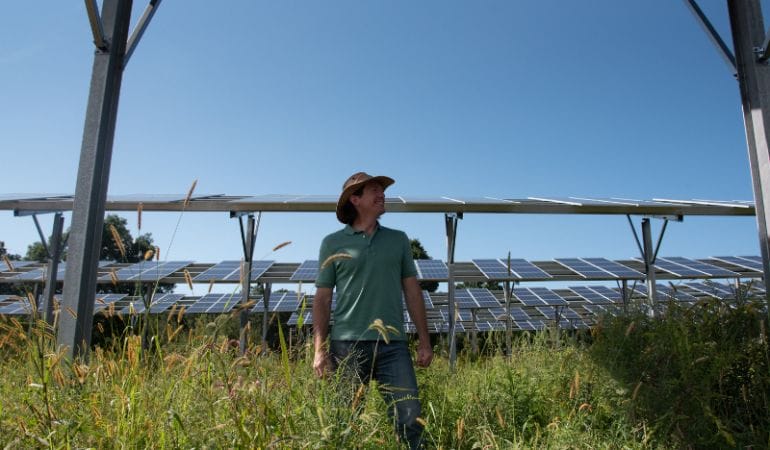
Not all dual-use solar developers pay stipends and hire farming consultants. Others simply pay the farmer to lease the land. “BlueWave’s model is progressive,” says Ward. “It’s farmer-first, farmer-friendly . . . the spirit of what I believe dual-use was intended to be.”
Ward is a cranberry grower and an evangelist for regenerative agriculture who views dual-use solar as an opportunity to pay farmers to experiment with growing crops in new ways. He launched his own consulting business, Solar Agricultural Services, a few years ago. Decked in jeans and T-shirt, boots, and a brown sun hat, Ward shows a visitor Knowlton’s second, much larger dual-use array, located in a former pasture down the road from the hayfield. The panels in both arrays are bifacial, he says, meaning they allow some sunlight to penetrate their surface and reflect off the ground, which provides the crops more sunlight. The field under this 11.5-acre array will become pasture for beef cows in a year or two. Knowlton will plant mainly forage grasses, with some radishes and sugar pumpkins to support soil health. The field is now planted with a cover crop of winter rye grass.
Knowlton is especially excited about the cows. “We haven’t had animals for so long,” he said wistfully, recalling how he used to milk the cows with his father and grandfather every weekend and every day after work. “I’m looking forward to getting back to that.”
Ward hopes the results from Knowlton Farm will help inform a national conversation that could spur greater adoption of dual-use solar. Research to date has largely been conducted in experimental settings. A University of Arizona study on cherry tomatoes and two types of peppers found that the crops did better because they were spared direct sun. Jalapeño peppers lost less water via transpiration, suggesting that growing crops under PV panels can save water in a hot, dry climate (Barron-Gafford et al. 2019).
Unpublished research from the University of Massachusetts similarly found that the solar panels helped reduce heat stress and contribute to higher yields for crops like broccoli, Swiss chard, kale, and peppers, though shade decreased yield in some crops (Sandler, Mupambi, and Jeranyami 2019). An analysis by researchers in Japan found certain types of agrivoltaic systems worked even with shade-intolerant crops like corn (Sekiyama and Nagashima 2019).
Dual-use solar is likely best suited for smaller projects in regions where competition for land is stiff, because the economics are difficult without incentives, and a tremendous amount of oversight and technical assistance is required to ensure that farm management plans are sound. Construction costs for dual-use solar are roughly 40 percent higher than for conventional solar, says Drew Pierson, head of sustainability at BlueWave. Raised canopies increase both materials and labor costs. Insurance costs are also higher because of ongoing activity underneath the panels.
Massachusetts leads the nation in dual-use solar because of its SMART program, which was designed to add 3,200 MW of solar to the grid. Under SMART, dual-use projects are eligible for a base compensation rate of $0.14–$0.26 per kWh of electricity produced, depending on the project size and local utility, and they receive an additional $0.06 per kWh federal incentive. To date, 11 projects, totaling 23 MW, have met the state’s rigorous eligibility requirements. (Even with the incentives, says De Villars, “the economics are very, very challenging, to say the least.”)
New Jersey passed a similar incentive to Massachusetts last year. New York scores solar projects better if they have agrivoltaic features, but it’s unclear whether that will help incentivize projects or simply hasten their permitting, says Pierson. Agrivoltaics are also being developed for pollinator fields and rangeland in the Midwest and West. Meanwhile, researchers in California are studying whether solar installations could keep fallow farmland from disappearing altogether.
Agriculture and Climate Change
Agriculture and associated land use changes such as deforestation produced an estimated 17 percent of global greenhouse gas emissions in 2018, according to the Food and Agriculture Organization (FAO) of the United Nations. Factor in related activities such as packaging and processing, says the FAO, and the food system accounts for 34 percent of all emissions—a figure expected to rise as global population soars. Even as it contributes to climate change, agriculture is vulnerable to climate impacts: hotter temperatures, droughts, pests, and flooding are affecting crop yields, livestock conditions, and other critical elements of a functioning food supply. Regenerative practices that restore ecosystem health and sequester carbon, such as no-till methods and use of cover crops, are increasingly touted as a way for farmers to build resilience and be part of the climate solution.
Solar on Farmland in the West
In the West, water—or lack of it—is emerging as a key driver for renewable energy siting on farmland. Severe drought linked to climate change is shrinking water supplies just as population growth is increasing demand. With the federal declaration of drought in the Colorado River Basin in 2021, farmers in central Arizona face steep cuts in their allotment of river water. California and Colorado are similarly struggling to balance agricultural water use, rising urban water demands, and shrinking resources.
“There’s always been this idea that the best soil is what determines the best agricultural land. We’re in a new paradigm here, and the best soil without water is dirt,” notes Lorelei Oviatt, director of planning for Kern County, California.
In an effort to gain control of dwindling supplies, California passed the Sustainable Groundwater Management Act (SGMA) in 2014. One of the act’s key strategies is fallowing farmland. With farmland transitions on the table in California and other places in the drought-stricken West, the Babbitt Center for Land and Water Policy is researching sustainable futures for agriculture, and how to get from here to there, says Holway, the center’s director.
Holway’s team is exploring how to facilitate voluntary transitions of agricultural land in a way that uses land markets, maintains agricultural economies, and keeps the most productive agriculture land in cultivation. The center is also investigating how to maximize ecosystem benefits and possibly sequester carbon on retired farmland. As part of this work, the Babbitt Center provided funding to the Public Policy Institute of California (PPIC) to investigate the potential for solar development in the San Joaquin Valley.
A state geologist measures water levels at an agricultural well in California’s Central Valley.
Credit: Kelly M. Grow/Department of Water Resources.
That region, which occupies the southern part of the state’s famously productive Central Valley, has the largest groundwater deficit in California and faces some of the worst impacts from overdraft, including land subsidence and drying wells, according to Ellen Hanak, vice president and director of the PPIC Water Policy Center. PPIC estimates that 10 to 20 percent of the valley’s farmland—500,000 to 1 million acres—will need to be retired to comply with the SGMA.
“If we don’t plan how that transition happens, it’s going to have a billion-dollar economic impact,” says Holway. Home foreclosures, bankruptcies, and supply chain disruptions are among the cascading impacts that could ensue from haphazard land fallowing. PPIC is studying how solar development can facilitate the necessary agricultural retirement in a way that sustains income for farmers. The research is part of a larger study on climate-smart agricultural transitions that is looking at the benefits and costs of different land management options. PPIC is also exploring issues such as the air quality risks that arise from the dust, pests, and weeds that build up from different types of land fallowing, and the potential for winter rain-fed cropping.
“We’re working with folks to look at some alternatives that could bring in revenues and avoid negative externalities, but also potentially generate some benefits, like soil carbon [storage], soil moisture retention, and habitat [protection]. Solar comes into this as one of the options that looks especially promising,” notes Hanak.
The Nature Conservancy (TNC) is also zeroing in on the San Joaquin Valley for renewable energy development. Its 2019 “Power of Place” report identified the San Joaquin as a promising location for the state to meet its renewable energy goals because it is more ecologically degraded than California’s inland deserts, where bighorn sheep, desert tortoises, and golden eagles still roam (Wu et al. 2019). California set a goal of reducing greenhouse gas emissions by 80 percent below 1990 levels by 2050. Additionally, it passed a law in 2018 requiring renewable energy resources to supply 100 percent of electricity by 2045.
“TNC is obviously in favor of renewable energy development, but we’re very interested in rolling it out in ways that don’t harm existing habitat,” emphasizes Abigail Hart, project director in TNC’s California Water Program. “If you’re going to site renewable energy facilities on conservation land or agricultural land, then you need to make sure you’re doing it in places that aren’t critically important for some other reason like habitat,” confirms Jim Levitt, director of the International Land Conservation Network at the Lincoln Institute. “It’s important to be strategic.”
Utility-scale solar is already underway in the San Joaquin Valley. Westlands Solar Park, one of the largest solar developments in the world, is under construction on 20,000 acres of former farmland that was contaminated with selenium in Fresno and King counties. The developer, CIM Group, plans to install at least 2,700 megawatts by the end of the decade, providing clean energy to more than 750,000 households.
A smaller, 20 MW project was installed by E.ON Solar at Maricopa Orchards, a Kern County grower of almonds, oranges, and other crops. That project is part of a 6,000-acre habitat conservation plan devised by Maricopa Orchards and local officials; the plan allows solar development on 4,000 acres of farmland, but sets aside 2,000 acres as habitat for San Joaquin kit foxes, blunt-nosed leopard lizards, burrowing owls, and other at-risk species. “In some cases, land that has been out of production even for a couple of years can function as habitat for at-risk species,” explained Hart. The 2,000-acre set aside will allow for wildlife corridors on the property. The 20 MW array, which occupies 160 acres and is now owned by Dominion Energy of Virginia, is the first of multiple expected projects on the rest of the Maricopa parcel. Hart said that TNC looks to the deal “as a compelling example of how solar development could be done on impaired lands in a way that provides renewable energy and valuable habitat.”
While wind and solar are high-value options for landowners, communities tend to question whether they provide “the same juice to the local economy” as housing or commercial development, says Hanak. Some communities, like San Bernardino County, have banned utility solar altogether.
California’s solar tax exclusion, a statewide incentive passed in the early 2000s that prevents the installation of qualifying solar energy systems from affecting the assessment of a property, is one reason why communities fret the economics. It made sense for rooftop installations and smaller-scale projects, but does not work for today’s large-scale solar projects, observes Oviatt. Hanak agrees, noting that PPIC is investigating “the different ways to pay for solar so that it’s not coming at the expense of the coffers of a poor rural county.”
There are other practicalities to consider. In Kern County, one of the largest in the valley, transmission capacity is a limiting factor, says Oviatt. Kern County has already developed 50,000 acres of solar, mostly on marginal lands. “We are now catching up with all of the solar that we have,” she says. Without additional transmission lines, farmers will not be able to sell their land to renewable energy developers. Kern County is therefore looking at other possible uses for retired agricultural land, including carbon capture and sequestration technologies.
Path Forward
Both dual-use and conventional solar development on farmland hold promise for helping individual states and the United States as a whole meet aggressive renewable energy goals. Solar on farmland cuts greenhouse gas emissions from the energy sector and, when done right, can help conserve land and protect biodiversity and water resources. Jeremy McDiarmid, vice president of the New England Clean Energy Council, points out that solar can be an impermanent development strategy, unlike housing or commercial real estate. What communities need to do, he says, is “find the balance between preserving open space and developing clean energy resources that are going to . . . create local jobs and help meet climate targets.”
American Farmland Trust is crafting a set of principles to guide siting of renewable energy on farmland in a way that protects farmers and, where farmland is still active, improves viability and productivity. Those principles also recommend making full use of locations like brownfields, abandoned mines, and urban rooftops. “There are plenty of options out there with limited land impacts,” says Haight. “However, we’re also aware that we will not be able to site everything on brownfields and within the built environment.”
Cole sees an opportunity for engaging in conversations state by state to identify where the best farmland is, what agricultural communities’ needs are, and what each state’s solar and land protection goals are to develop state-specific guidelines and programs.
Such conversations are just beginning in California, Massachusetts, and New York. In California, the Strategic Growth Council, a state agency, is funding PPIC’s climate-smart agricultural transition and solar research to help plan the San Joaquin Valley’s future. In Massachusetts, the Department of Energy Resources is studying the solar potential for the Commonwealth and will likely layer in both technical feasibility and competing land uses for biodiversity and open space protections, according to McDiarmid. And in New York State, Cornell Professor Max Zhang said his recent study on strategic land use analysis for solar energy development precipitated a meeting with state senators (Katkar et al. 2021).
Meanwhile, Levitt thinks the agricultural sector could see additional disruptions in the next few decades. Severe water shortages in arid and semi-arid landscapes are one potential driver of change. The traditional dairy and meat industries could also be increasingly displaced by alternative products such as nut milks and synthetic meats. Such disruption could free up a substantial amount of land for regenerative farming, renewables development, carbon sequestration, aquifer recharging, and wildlife protection, particularly in the swath of the middle of the country that’s now used for pasturing livestock and growing the crops that feed them.
“Just as change in the pattern of land use in California is emerging, these trends could alter longstanding patterns of land use across North America,” says Levitt. While powerful industrial agriculture associations will do what it takes to minimize disruption—as will states where agriculture is integral to identity, culture, and economics—Levitt says the potential for dramatic change is there, and the forces driving change may well intensify over time.
As dual-use systems get up and running on Knowlton Farm and elsewhere, questions remain about how scalable dual-use solar will be across different geographies and farm systems. Scaling up conventional solar on retired farmland is more straightforward, but will likely be limited by such factors as local transmission capacity or economic incentives. Regardless, solar energy development on both working and non-working farmland is an important tool for confronting the climate crisis. The faster the solar industry can perfect systems that keep farmers on their land and agricultural production intact—or optimized for water sustainability—the better humanity’s chances for preserving a livable planet.
Meg Wilcox is an environmental journalist covering climate change, environmental health, and sustainable food systems. Her work has appeared in The Boston Globe, Scientific American, Next City, Smithsonian, Salon, Eater, Civil Eats, and other outlets.
Lead image: Solar consultant Iain Ward stands among the agrivoltaic panels at Knowlton Farm in Grafton, Massachusetts. Credit: Meg Wilcox.
References
Barron-Gafford, Greg A., Mitchell A. Pavao-Zuckerman, Rebecca L. Minor, Leland F. Sutter, Isaiah Barnett-Moreno, Daniel T. Blackett, Moses Thompson, Kirk Dimond, Andrea K. Gerlak, Gary P. Nabhan, and Jordan E. Macknick. 2019. “Agrivoltaics Provide Mutual Benefits Across the Food-Energy-Water Nexus in Drylands.” Nature Sustainability 2: 848–855. https://www.nature.com/articles/s41893-019-0364-5.
Larson, Eric, Chris Greig, Jesse Jenkins, Erin Mayfield, Andrew Pascale, Chuan Zhang, Joshua Drossman, Robert Williams, Steve Pacala, and Robert Socolow. 2020. “Net-Zero America: Potential Pathways, Infrastructure, and Impacts.” Princeton, N.J.: Princeton University. December 15. https://netzeroamerica.princeton.edu/img/Princeton_NZA_Interim_Report_15_Dec_2020_FINAL.pdf.
Sekiyama, Takashi, and Akira Nagashima. 2019. “Solar Sharing for Both Food and Clean Energy Production: Performance of Agrivoltaic Systems for Corn, a Typical Shade-Intolerant Crop.” Environments 6(6): 65. https://doi.org/10.3390/environments6060065.
Wu, Grace C., Emily Leslie, Douglas Allen, Oluwafemi Sawyerr, D. Richard Cameron, Erica Brand, Brian Cohen, Marcela Ochoa, and Arne Olson. 2019. “Power of Place: Land Conservation and Clean Energy Pathways for California.” Washington, DC: The Nature Conservancy. August. https://www.scienceforconservation.org/products/power-of-place.