
Mostrando All Types

¿Cómo se ven 15 viviendas por acre?
Este mapa explora cómo se ve la métrica en el mundo real, con fotografías de las calles en Gran Boston donde la densidad bruta de los barrios es de alrededor 15 viviendas por acre o más.
Planos e infografías
Planificación urbana y regional, Tecnología e instrumentos, Uso de suelo y zonificación, Vivienda

The Hardest Working River in the West
This StoryMap introduces viewers to the key water sustainability issues in the Colorado River Basin through data and stories. Although not the largest or longest river in the world, the Colorado River connects a rich array of social and ecological communities along its 1,450 mile journey from its headwaters in the Rocky Mountains of Colorado to its mouth in the Gulf of California, Mexico.
Planos e infografías
Cambio climático, Medio ambiente, Uso de suelo y zonificación, Agua
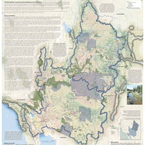
Map: Colorado River Basin
Text by Matt Jenkins and design by Jeff Allenby and Chaz Baculi
Mayo 2021, inglés
Planos e infografías
Medio ambiente
Mayo 2021, inglés
Planos e infografías
Medio ambiente
Atlas of Urban Expansion
Aplicaciones
Infraestructura, Uso de suelo y zonificación, finanzas públicas, urbanización
Aplicaciones
Infraestructura, Uso de suelo y zonificación, finanzas públicas, urbanización
Suscribirse para recibir actualizaciones del Programa para Latinoamérica y el Caribe y cada vez que la edición en español de Land Lines sea publicada en nuestro sitio web.