This content was developed through a partnership between the Lincoln Institute and the American Planning Association as part of the APA Foresight practice. It was originally published in APA’s Planning magazine.
COVID-19 has turned the world upside down. When the American Planning Association’s Foresight team entered the second year of our partnership with the Lincoln Institute of Land Policy, the symptoms and side effects of the pandemic were reflected in nearly every trend, changing the way we live, work, and play. And while the world is still trying to flatten the COVID curve, we need to flatten others—social inequalities, the climate emergency, and the speed of technological innovation that makes it difficult to keep up.
This year, we’re publishing the 2022 Trend Report for Planners, your foresight-driven road map for the new year and beyond. With guidance from our Trend Scouting Foresight Community, a diverse group of 31 forward-thinking thought leaders, we’ve identified what planners need to act on today, what we need to start preparing for, and what we need to better understand and continue watching throughout the year. The report also takes a look at some big-picture developments and trend patterns and what they mean for the future of planning.
Here, take a sneak peek (in no particular order) at seven of the nearly 100 trends and signals from the report. Additional topics range from innovative ways to encourage equitable community investment to the future of data collection and analytics, the climate emergency, and political polarization. We’re also working on finding answers to some of our most pressing questions: What’s the future of transportation? How can 3D printing be a part of the solution to the housing crisis? And why should it matter to planners when Jeff Bezos starts sending tourists into space?
Read on for some of the answers and more.
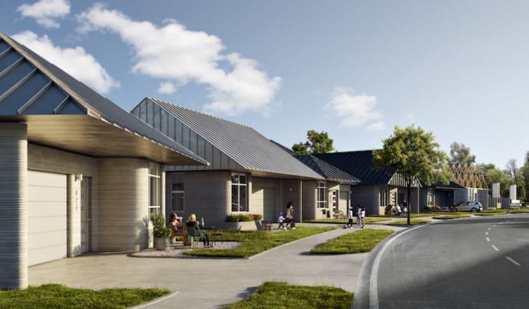
1. CTRL + P HOUSING
We’ve long been tracking the potential impacts of 3D printing on planning, but in the past year, the trend has moved up from our watchlist to our high-priority trend list as housing and infrastructure projects get underway.
Specifically, we’re closely observing a development near Austin, Texas. The 3D printing company ICON has joined forces with real estate developer Lennar and architecture firm Bjarke Ingels Group to build the largest community of 3D-printed homes to date. The project will print 100 energy-efficient houses that claim to be built faster, with less waste, and to last longer than conventional construction.
The tech could prove to be an attractive solution to many issues, from the housing crisis to supply chain challenges. Some companies are even exploring 3D-printed food. While the broader impact of Austin’s 3D-printed neighborhood is yet to be seen, this is certainly a trend planners should keep a close eye on.
2. The Great Resignation
The term was coined by Anthony Klotz, a psychologist and professor at Texas A&M, to describe the record-high wave of people quitting their jobs in 2021. According to the U.S. Bureau of Labor Statistics, four million people resigned in April 2021, and by July, the Bureau had registered almost 11 million open jobs.
The most impacted sectors are food and hospitality, comprising 6.8 percent of U.S. resignations in August 2021 alone. Outside the leisure sector, retail has been hit the hardest, with 4.7 percent in the same month. Health care, IT, construction, and transportation also have been affected.
Looking at these numbers, the COVID-19 connection becomes very clear. Many of those who resigned were low-wage workers in frontline positions during the darkest months of the pandemic, or those who worked in industries that experienced extreme growth in the past few years. But the pandemic isn’t the only reason for this development.
The trend of low-wage workers resigning was already building in 2019. Though it paused during the worst of the pandemic, it picked back up more intensely in 2021. That’s because the root causes—lack of benefits, minimum wage levels, and generally poor working conditions—existed well before COVID. The pandemic only added to these factors, increasing demand and burnout while introducing more safety and health concerns.
For people who shifted to working from home (or working from anywhere—yes, that’s also in our report), the motivation to change jobs is different. Working from home means more flexibility, eliminated commutes, increased time with family and friends, and, for many, the opportunity to reconsider the so-called work-life balance.
According to psychologist Klotz, who we are as employees has long been key to American identity. But working from home has driven people to shift their priorities and focus on life outside of work. Klotz argues that near-death situations or life-threatening illnesses usually inspire people “to take a step back and ask existential questions,” he told Business Insider. “Like, what gives me purpose and happiness in life, and does that match up with how I’m spending my time right now?”
Employers will need to keep this in mind when hiring new staff. Companies that don’t offer certain perks in a post-COVID world will have a hard time finding competitive employees. The Great Resignation is currently spurring an increase in wages for low-income workers at a rate not seen since the Great Recession.
These workforce trends will likely be impacted by another in the report: the development and deployment of robots has been accelerated during COVID as well. The industry sectors that are currently hit the hardest by the Great Resignation are also the ones that have been experimenting with robots. AI-powered robots are now being used in recycling facilities, for food deliveries, and in many other service industries. KFC opened its first contactless, robo-based restaurant in Moscow last year, while multiple cities in the U.S. and across the globe are now allowing for automated delivery services.
While the connection between urban planning and automated delivery services might be obvious, it’s not clear today how the Great Resignation and tech innovations in the service industries will further affect how we plan for our communities and the people who live in them. We can already see, though, that it’s impacting how people live, work, play, and move around, which means it must factor into how we think about future economic development, land use, and transportation planning.
3. Space Oddity
A new space race is underway, this time among private corporations like SpaceX, Blue Origin, Virgin Galactic, and the United Launch Alliance.
This competition is fueling a revolution in launch capabilities in the U.S. and abroad that is leading to major cost reductions and sustained interest in the commodification of space. This commercialization and privatization can generally be explored in the context of three emerging trends: growing competition for commercial satellite launches, space tourism, and the long-term colonization of space.
Right now, it’s unclear how planners will be involved in space colonization, but it’s certainly something to keep an eye on. Currently, space travel mainly disrupts communities with launch sites, like Boca Chica, Texas, where test launches and failures occur.
4. Departure from the Cave
If your employer asks you to come back to the office a few days a week but you’re still wary about sharing a space with multiple people; if you recently went to a restaurant and couldn’t wait to get back home; or if you went to the movie theater only to change your mind at the box office, even while vaccinated, you are not alone.
Researchers at the University of California (UC), Berkeley, have been exploring a phenomenon called “cave syndrome.” For many, staying at home and away from people for almost two years has made it difficult to readjust to the social, public lives we once led. In general, the pandemic has caused an increase in mental health issues, including anxiety and depression.
While many people might be comfortable with their current work-from-home situation, UC Berkeley professor Robert W. Levenson says that, especially for young people, it is critical to leave the pandemic cave, reconnect with the outside world, and (re)establish a social life and career outside the home.
“Young people need to be in environments where unexpected things happen and where they are challenged and inspired,” he told Berkeley News. “They need to flex their emotional and perceptual muscles.”
Emiliana Simon-Thomas, science director at UC Berkeley’s Greater Good Science Center, believes reestablishing these connections will be crucial for all of us to create a “sense of common humanity and collective interests.” Emerging from our pandemic caves might take a while, but “being physically near each other and not experiencing harmful or threatening consequences is the way that our nervous systems need to relearn the foundational trust and the affiliative and cooperative potential that is so fundamental to human ultra-sociality.”
Planners can play an essential role in addressing mental health issues like pandemic cave syndrome. Location, equitable design, and accessibility of public and green places determine how we feel and experience space, and they can be important factors in our decision to leave the house in the first place. Planning can create spaces where unexpected things happen, where we are challenged in a good way, where we are inspired. And if done right—with intentional consideration for equity, diversity, and inclusion—planning can get us out of our caves and back in public spaces.
5. Green Signals from Across the Pond
The report takes a deep dive into environmental concerns, like the fact that we are running out of time when it comes to the climate emergency. But we’re also observing some green signals on the horizon.
As some European countries ban short-distance flights, cities are transitioning to a car-free era. Oslo, Norway, and Ljubljana, Slovenia, have already converted their entire downtown areas into car-free zones, while Paris and many others have implemented or are planning extensive car-free areas throughout cities.
It’s not an entirely foreign concept in the U.S. During the COVID-19 pandemic, many American cities converted streets into shared or pedestrian zones, some permanently. Making streets a place where people can safely spend their leisure time has become a widely embraced trend and should continue to be considered by planners when imagining healthy, environmentally responsible communities.
Another green signal from abroad is the uptick in the circular economy, an approach to sustainable production and consumption that prioritizes sharing, leasing, reusing, repairing, refurbishing, and recycling products and materials. In 2018, China stopped taking plastics from many countries, including the U.S. As a result, these countries had to get creative about what to do with their waste. The EU adopted the Circular Economy Action Plan (CEAP) in 2020, a mix of legislative and non-legislative measures. The circular economy is starting to grow in the U.S., with more retailers exploring buyback and recycling programs. And as supply chain backups continue, we could see this trend further accelerate.
6. Zoning Reform Goes Mainstream
Single-family housing is the dominant residential land use in the U.S., largely due to local zoning codes and maps that have remained unchanged for decades—but not for much longer.
Many local governments are looking into zoning reform as a means of increasing housing choice and affordability and reducing racial and economic segregation. With cities like Minneapolis revising their codes to permit “missing middle” housing types in formerly restrictive districts and California and Oregon instituting statewide bans on single-family-only zoning, a movement is building, and quickly. Even at the federal level, legislators are working to tie local funding to the revision of exclusionary zoning regulations.
Expect these measures to gain further momentum in cities and states of all sizes as housing costs, displacement, and homelessness continue to rise.
7. Welcome to the Metaverse
The digitalization of life continues to accelerate. The term “metaverse,” which was coined in the 1990s, has gained more attention since Facebook changed its name to Meta in October 2021. And while it doesn’t exist just yet, it might be the next step in the evolution of the internet.
The metaverse is a computer-generated universe or “extended reality” that combines augmented, virtual, and mixed reality. According to proponents, it will be the new platform we use to socialize, conduct business, and do anything else that can be done in a virtual, 3D space. It’s expected to be as transformative to the ways we live, work, and play as the cell phone. And those of us growing tired of being on video all day can create cartoon avatars who mimic our facial expressions, wear digital outfits we buy, and take on alternate personalities.
In his announcement about Meta, founder Mark Zuckerberg said he envisions the metaverse as “an embodied internet, where instead of just viewing content, you are in it. And you feel present with other people as if you were in other places, having different experiences that you couldn’t necessarily do on a 2D app or web page, like dancing, for example, or different types of fitness.”
As the company’s new name reveals, Meta plans to be a big player in this space. So do others in the big tech sector, ranging from Microsoft to Epic Games. Tech giants have often been accused of prioritizing profit over the common good, or as Jessa Crispin, columnist at the Guardian, put it around the time former Amazon CEO Jeff Bezos briefly traveled to space, “tech billionaires [are] trying to leave the world to evade responsibility for their malevolent influence on it.” Many believe that allowing these companies control over the metaverse could be a dystopian nightmare.
So far, it’s not clear what the metaverse will mean for privacy, how inclusive the experience will be, or how harmful content will be mitigated or avoided. There’s obviously a lot to unpack here, but it could have enormous impacts on the trajectory of our future. We face great risks repeating past mistakes from the analog world in a digital society. Ultimately, we need to think carefully and critically about how people will engage with this platform and how that will change lifestyles, behaviors, and the work of planners.
Petra Hurtado, Ph.D., is the research director of APA. Learn more about APA’s applied research program.
Image: Conceptual rendering of a 3D-printed community planned in Austin, Texas. Credit: ICON.