Mostrando All Data

Grassroots Conservation (Minus the Grass)
A growing movement is inviting nature back into the cities and towns from which it was once expelled, planting native pollinator gardens and Miyawaki microforests in front yards, schoolyards, parks, and vacant lots. This StoryMap explores how individuals and municipalities are creating and protecting habitat at the local level.
A growing movement is inviting nature back into the cities and towns from which it was once expelled, planting native pollinator gardens and Miyawaki microforests in front yards, schoolyards, parks, and vacant lots. This StoryMap explores how individuals and municipalities are creating and protecting habitat at the local level.
Visualizing Density
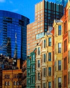
Visualizing Density is an online database featuring more than 100 images of density in the built environment across the US, with associated characteristics including walkability and access to transit and amenities. The site provides extensive background and resources related to density, which is increasingly a contentious public policy issue in the context of infill redevelopment and zoning reform aimed at increased supply of housing.
Planificación urbana y regional, Vivienda, Uso de suelo y zonificación

¿Cómo se ven 15 viviendas por acre?
Este mapa explora cómo se ve la métrica en el mundo real, con fotografías de las calles en Gran Boston donde la densidad bruta de los barrios es de alrededor 15 viviendas por acre o más.
Planificación urbana y regional, Tecnología e instrumentos, Uso de suelo y zonificación, Vivienda
Este mapa explora cómo se ve la métrica en el mundo real, con fotografías de las calles en Gran Boston donde la densidad bruta de los barrios es de alrededor 15 viviendas por acre o más.
Planificación urbana y regional, Tecnología e instrumentos, Uso de suelo y zonificación, Vivienda

