Topic: Preservação Fundiária

Conferências

2027 Global Congress of the International Land Conservation Network

Outubro 26, 2027 - Outubro 29, 2027

Offered in inglês

October 26-29, 2027

The ILCN, a project of the Lincoln Institute will host its fifth Global Congress from October 26–29, 2027, in Naarm (Melbourne), Australia.

Every three years, the ILCN Global Congress brings together practitioners, leaders, funders, researchers, and communities advancing private and community-led land conservation around the world to build capacity, catalyze collaboration, and leverage global expertise to develop and scale solutions. Each Global Congress strengthens this growing community of practice, showcases host-country leadership, and accelerates the ideas, investment, and partnerships needed to secure healthy ecosystems and their cultural, social, economic, and environmental benefits.

The 2027 ILCN Global Congress, cohosted by the Australian Land Conservation Alliance (ALCA), centers around the theme “People. Nature. Action: Delivering on a Global Conservation Agenda,” and will focus on the role of private and community-led land conservation in achieving equitable, effective, and enduring conservation outcomes. The program will be organized around six streams: Conservation Finance; Policy and Law; Strong Organizations and Future Leaders; Climate Change; Land, Water, and Landscapes; and First Nations.

ILCN and ALCA are calling for proposals for workshops, sessions, and presentations that share important ideas, initiatives, and innovations with this global community of practice. Proposals are due by October 19, 2026, and accepted presenters will be notified by late November. Proposals should demonstrate a clear connection to at least one stream above.


Session Proposal Details

Prazo para candidatura
Outubro 19, 2026 às 11:59 PM
Data de notificação de seleção
Novembro 30, 2026 às 12:00 AM

The application deadline is October 19, 2026 at 11:59 PM.


Palavras-chave

Preservação

International Research for the Study of China’s Urban Development and Land Policy 2027-2028

Prazo para candidatura: November 10, 2026 at 11:59 PM

The Lincoln Institute of Land Policy’s Program on the People’s Republic of China invites applications for the annual International Research for the Study of China’s Urban Development and Land Policy Program. We seek applications from academic researchers working on the following topics in China:

  • Land use, carbon neutrality, and spatial planning and governance;
  • Urban regeneration;
  • Municipal finance and land value capture;
  • Impacts of New Urbanism;
  • Land policies;
  • Housing policies;
  • Urban environment and public health; and
  • Land and water conservation.

The program aims to promote international scholarly dialogue on China’s urban development and land policy, and to further the Lincoln Institute’s objective to advance land policy solutions to economic, social, and environmental challenges. The award is for scholars who are based outside of mainland China. In 2026, three individuals received funding for their research.

The Peking University – Lincoln Institute Center for Urban Development and Land Policy has more information about a separate opportunity for scholars based in mainland China on its WeChat channel.


Detalhes

Prazo para candidatura
November 10, 2026 at 11:59 PM

Palavras-chave

Desenvolvimento Urbano

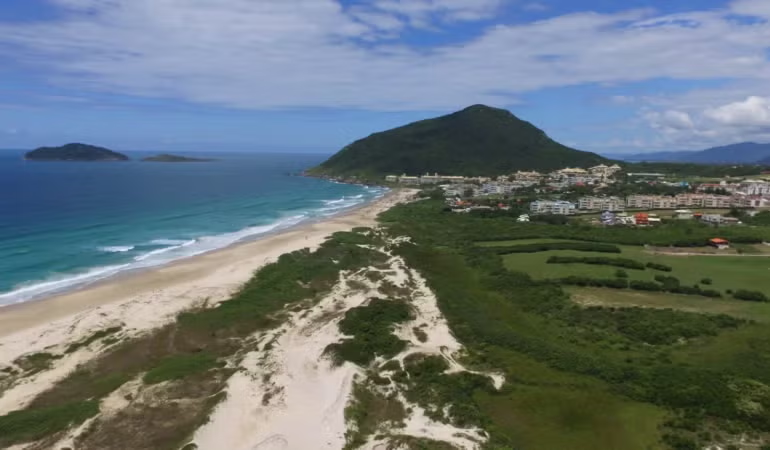
La vista de la costa del mar. Al fondo se ve un pueblo y una pequeña montaña.

Reservas privadas del patrimonio natural: un pilar del movimiento de conservación de tierras privadas en América Latina

Por Hernán Mladinic, Agosto 11, 2026

En las últimas tres décadas, ha surgido en Brasil una fuerza transformadora para la conservación de la naturaleza: los terratenientes privados. El liderazgo del país en la conservación de tierras privadas a través de reservas privadas de patrimonio natural (RPPN) ha dado como resultado uno de los modelos de conservación voluntaria más sólidos y duraderos del mundo. Este enfoque integra los derechos de bienes inmobiliarios con una responsabilidad ecológica perpetua y, ahora, sirve como ejemplo en América Latina y fuera de ella.

Este artículo ofrece un panorama general de la historia, el marco legal, los logros, los desafíos y las oportunidades de las RPPN en Brasil.

De la iniciativa del terrateniente a la política nacional

Las RPPN no se originaron en las oficinas del gobierno, sino en los bosques de propiedad privada de Brasil. Durante las décadas de 1970 y 1980, los terratenientes comprometidos con la conservación, preocupados por la caza furtiva y la tala ilegal, comenzaron a buscar mecanismos legales para proteger sus tierras. Sus esfuerzos finalmente dieron lugar a la primera designación formal de reservas privadas de patrimonio natural (RPPN) creada por el Decreto Federal 98.914 en 1990.

Esta designación se detalló en mayor medida en 1996 y en el 2000, con la promulgación de la Ley 9.985, que estableció el sistema nacional de áreas protegidas de Brasil. La ley reconoce las RPPN como una categoría de áreas protegidas, denominadas en Brasil como unidades de conservación; las define como áreas de propiedad privada protegidas a perpetuidad para conservar la diversidad biológica; y las incorpora al sistema nacional de áreas protegidas.

Una regulación federal posterior, el Decreto 5.746, describe los procedimientos para su establecimiento, así como los derechos y las responsabilidades de los terratenientes, bajo la supervisión de la agencia medioambiental federal de Brasil, el Instituto Chico Mendes para la Conservación de la Biodiversidad.

Perpetuidad y uso restringido

Una característica definitoria de las RPPN es su establecimiento a perpetuidad. Una vez reconocida, una RPPN se inscribe en un registro nacional y se le otorga protección legal permanente que está vinculada a la escritura de la propiedad, al margen de los cambios en la propiedad por venta o herencia. Las RPPN designadas están exentas del Impuesto a la Tierra Rural de Brasil, lo que proporciona un importante incentivo fiscal para los terratenientes. Como Unidades de Protección Integral dentro de las categorías de áreas protegidas de Brasil, las actividades en las RPPN están estrictamente restringidas a las que son compatibles con la conservación, como la investigación científica, la educación medioambiental, el ecoturismo y la recreación.

Durante la década del 2000, varios estados brasileños adoptaron regulaciones para reconocer las RPPN dentro de sus jurisdicciones, y muchos municipios incorporaron incentivos y procedimientos para el reconocimiento local. En 2006, el marco federal para las RPPN se consolidó con la creación del Plan Estratégico Nacional de Áreas Protegidas (PNAP) (Decreto n.º 5.758), que refuerza la función de las RPPN como componentes esenciales de la conectividad del paisaje, los corredores ecológicos y un sistema nacional de áreas protegidas más efectivo y con equidad social. Estos esfuerzos facilitaron una mejor alineación y coordinación de las RPPN entre las redes regionales de terratenientes, las organizaciones de sociedad civil y las autoridades medioambientales en varias escalas.

Una red nacional para las RPPN

Una fuente clave de apoyo y crecimiento para el movimiento de conservación de tierras privadas en Brasil es la Confederación Nacional de Reservas Privadas del Patrimonio Natural (CNRPPN), que reúne a asociaciones de terratenientes, redes regionales y aliados institucionales en todo el país. La CNRPPN desempeña un papel fundamental en la promoción, la asistencia técnica y el desarrollo de capacidades, y brinda apoyo a las reformas regulatorias, los programas de incentivos y los procesos de planificación estratégica para las RPPN.

La CNRPPN alberga información sobre el alcance y la cobertura de las RPPN en todo el país a través del Panel Nacional de RPPN. Este panel, que es el resultado de un esfuerzo colaborativo entre docenas de profesionales y organizaciones dedicadas, hoy es la base de datos más completa sobre RPPN disponible en Brasil. Permite la supervisión de datos en línea, como el número y el área de RPPN por estado, bioma y categoría, así como el aumento de RPPN con el paso del tiempo. Esta infraestructura de datos fortalece la capacidad de promoción de la Confederación, facilita la comunicación con las autoridades públicas y proporciona pruebas concretas del compromiso con los financiadores y los socios internacionales sobre la contribución medible de las RPPN a objetivos como la Meta 3 del Marco Global de Biodiversidad Kunming-Montreal.

Alcance y cobertura

Según el panel, se calcula que hay 1.902 RPPN que protegen alrededor de 837.635 hectáreas (unos 2 millones de acres) en todos los biomas principales de Brasil: el Amazonas, el Cerrado, el Bosque Atlántico, la Caatinga, la Pampa y el Pantanal, con un enfoque estratégico en paisajes fragmentados. En el Bosque Atlántico, donde más del 80 por ciento de la tierra es de propiedad privada, las RPPN funcionan como importantes refugios para las especies endémicas y ayudan a conectar sus hábitats con los fragmentos de bosques públicos. Al funcionar como zonas de amortiguamiento y corredores biológicos, las RPPN demuestran la complementariedad de los esfuerzos públicos y privados para mantener la conectividad y la resiliencia de los ecosistemas más amenazados de Brasil.

La CNRPPN trabaja en estrecha coordinación con el Ministerio de Ambiente y Cambio Climático de Brasil, en particular, con la Secretaría Nacional de Biodiversidad, Bosques y Derechos de los Animales y el Departamento de Áreas Protegidas, que lideran la implementación de la política nacional de biodiversidad y la gestión de áreas protegidas. Esta colaboración intersectorial entre el gobierno, los terratenientes y las organizaciones sin fines de lucro ha permitido que las RPPN se vuelvan una parte fundamental de los esfuerzos de conservación a escala del paisaje.

Crecimiento y sostenibilidad de las RPPN en Brasil

Las RPPN han demostrado ser un mecanismo de conservación con un alto nivel de eficacia en Brasil, pero su crecimiento continuo y la sostenibilidad a largo plazo están lejos de estar garantizados. Los terratenientes asumen el costo total de la administración y la supervisión, incluso con el aumento de las presiones de la expansión agrícola, las interpretaciones cambiantes de la ley medioambiental y los impactos crecientes del cambio climático, como inundaciones e incendios forestales cada vez más graves.

Como respuesta, están surgiendo soluciones. Brasil está promoviendo políticas que permiten que los terratenientes de RPPN reciban una compensación por los servicios ecosistémicos que brindan, incluido el suministro de agua, la captura de carbono y la conservación del hábitat. Al mismo tiempo, están ganando terreno varios enfoques de financiamiento, desde el turismo basado en la naturaleza hasta los mercados de carbono, mediante el aprovechamiento del liderazgo de Brasil en el desarrollo de metodologías para créditos de carbono en reservas privadas. La innovación en las políticas, el financiamiento y la administración están mejorando las condiciones, los incentivos y los resultados para la conservación voluntaria.

Un líder regional en conservación de tierras privadas

La experiencia de Brasil con las RPPN ofrece lecciones valiosas para la conservación de tierras privadas en América Latina y fuera de ella, lo que demuestra que dichas iniciativas tienen éxito cuando los terratenientes motivados cuentan con el apoyo de un marco legal permanente y fuertes redes nacionales y subnacionales que brindan una colaboración estrecha con el sector público.

Mientras la comunidad privada de conservación de tierras de América Latina se prepara para el 14.º congreso en México en 2027, las RPPN de Brasil se erigen como un modelo de cómo las tierras privadas pueden ofrecer una protección duradera de la biodiversidad y contribuir estratégicamente a los objetivos y las metas de conservación de las políticas nacionales e internacionales.


Hernán Mladinic representa a América Latina en el International Land Conservation Network (ILCN) del Instituto Lincoln.

Puede encontrar la versión en inglés de este artículo en el sitio web del ILCN.

Crédito imagen principal: Ciro Couto.

Blog Post
Photo of an urban garden and stream at Mears Park in Lowertown St. Paul.

Delivering Community Benefits from Community Lands Through Conservation and Nature-Based Solutions

By Chandni Navalkha and Peter Colohan, Junho 22, 2026

As communities across the country face the combined impacts of the housing affordability crisis, climate change, and biodiversity loss, state and local governments are exploring how to deploy underutilized land they own to meet multiple community needs. The Lincoln Institute’s Community Land for Community Benefits campaign aims to inform, complement, and increase the speed and scale of the work required to identify these lands and decide how to use them.

Conserved natural areas provide public benefits and ecosystem services

Most often, state and local officials are using community land to fill gaps in the affordable housing supply. As these efforts become more common, communities should ensure that conservation and development work together, not against one another.

Conserved lands are natural infrastructure. They’re essential to delivering clean air and water and supporting public health and recreation. They provide water filtration, flood control, groundwater recharge, climate regulation, air quality, coastal protection, habitat protection for pollinators, and other ecosystem services that are imperative to strengthening resilience in a changing climate.

As community leaders work to ensure that state and locally owned lands produce enduring benefits for residents, it will be essential to identify and delineate natural and working lands such as forests, wetlands, grasslands, and agricultural lands for conservation. Prioritizing lands that strengthen ecological connectivity will help secure ecosystem services at a large scale. Using durable mechanisms such as conservation easements will help secure long-term benefits that serve present and future generations.

Conservation and affordable housing development can find common ground

In many places and communities, tensions may arise between affordable housing development and sustainable land and resource management. But as efforts like the Conservation Lands Foundation’s Shared Ground initiative demonstrate, these enterprises do not have to clash if decisions about land use are made wisely. Affordable housing is often more compatible with land conservation than market-rate housing development is. Ensuring that affordable housing is built on already-developed, transit-accessible, underutilized parcels—rather than on converted natural or working lands—increases densification and alleviates pressure on urban, suburban, and rural natural areas and open space. And communities may be more likely to support affordable housing if it is paired with conserved open space to which they have access.

Conservation is just one of many nature-based solutions

In addition to the direct benefits of conserving community land, such as fostering healthy natural ecosystems and creating community well-being through public access to green space, the idea of using community land for nature-based solutions is gaining traction.

Nature-based solutions are actions to preserve or protect natural or modified ecosystems in ways that benefit both humans and biodiversity. In urban and suburban or rural contexts, this refers to green infrastructure deployed in and around the human-built environment, such as rain and pollinator gardens, community gardens, bioswales, green roofs, retention ponds, and tree plantings. Such interventions are frequently designed to reduce the flood impacts of runoff from impervious surfaces—such as roads, parking lots, sidewalks, and rooftops—which is particularly important during storm events. In suburban and rural environments, this list can expand to include riparian buffer zones that protect streams and rivers from agricultural runoff, and wetlands protections that ensure floodplain connectivity and help sustain water supply and regional hydrologic function. In most cases, these forms of nature-based solutions and other targeted interventions create shading and cooling effects, reducing heat-island impacts.

Communities facing extreme weather events, water stress, and other climate shocks are pursuing nature-based solutions with new urgency. These practices are being combined with concepts like climate-resilient zoning, which restricts development in high-risk flood zones or fire corridors. For example, dedicating community land to the development of “flood-able” parks and green spaces—which are intentionally engineered to receive floodwater during a storm event—builds climate resilience while strengthening the region’s biodiversity and ecosystem function. Similarly, in suburban and rural areas in arid climates, approaches such as managed-aquifer recharge—which directs floodwater to specific parcels of land to recharge the groundwater basin—are reducing water stress and increasing drought resilience.

Deploying land through a multiple-benefits frame

In short, the most innovative communities fully leverage their community land by exploring multipurpose re-use concepts and solutions to address an uncertain future. Bringing together housing, conservation, and nature-based solutions in a portfolio approach is the key to ensuring that state and locally owned lands deliver multiple, enduring benefits that enable human communities—and the natural systems on which they depend—to flourish.


Chandni Navalkha is director of conservation and stewardship and Peter Colohan is director of partnerships and program innovation at the Lincoln Institute of Land Policy.

Lead image: Urban Garden and stream at Mears Park in Lowertown St. Paul. Credit: JoeChristensen via Getty Images.

Blog Post
Construction cranes work on in-progress apartment buildings above a park in South London's Elephant & Castle neighborhood.

How Land Value Capture Can Support Biodiversity, Disaster Recovery, and Climate Adaptation

By Jon Gorey, Maio 18, 2026

Like most places these days, the United Kingdom needs more housing. But that housing won’t come at nature’s expense—at least not in England, where since 2024, any new construction project must be accompanied by a 10 percent net gain in biodiversity, ideally on the same site.

Whether that entails restoring wetlands or reforesting farmland, the improvements are intended to leave the immediate natural environment better off than it was before the development. But where that proves impossible, the goal of a “net” gain allows developers to engage in off-site conservation efforts or, as a last resort, to purchase biodiversity credits to fund habitat restoration and preservation elsewhere.

Prioritizing biodiversity has direct benefits for humans and other species, from ensuring clean air to protecting habitats. It also helps build climate resilience, whether in the form of trees that provide shade in overheated urban areas or soil that absorbs and stores carbon. The question for many communities is how to pay for such nature-based solutions—and one answer lies in the value of the land itself.

Passed in 2021, England’s Biodiversity Net Gain (BNG) rule is a form of land value capture, a strategy that allows communities to recover and reinvest some of the increases in land value that arise from development due to public investment or government actions, such as zoning changes. Researchers at the University of Liverpool are looking at the connection between land value capture and climate adaptation, and investigating how the BNG rule is affecting local fiscal strategies.

UK municipalities already had a few value capture tools available to them, from locally negotiated planning obligations to the Community Infrastructure Levy. Such revenues can fund investments in education, transportation, parks, or other public goods, but “the majority of land value capture in England is used for affordable housing,” says Richard Dunning, professor of land economy and housing at the University of Liverpool.

That left Dunning and his colleague, fellow University of Liverpool professor Alex Lord, curious about the impacts of the Biodiversity Net Gain rule—both its measured contributions to biodiversity and its impact on other value capture programs. The UK’s other main value capture tools are mostly used at the local level on a case-by-case basis, Dunning says. As a national policy, BNG has essentially moved the environment to the front of the queue, ahead of other land value capture opportunities that fund, say, affordable housing.

“[If] the first thing a developer needs to do is to ensure that they leave the environment in measurably better condition than when they started, that is effectively the first request you have made of them,” Lord explains. Whether that could “crowd out other forms of investment” is one of the questions the professors aim to answer by focusing on three unique case studies with support from the Lincoln Institute of Land Policy.

“It could be the case that putting biodiversity first in the queue actually makes the development worth more, so that there’s actually more [value] available to go into some other things,” Lord explains. For instance, many studies of statistically identical houses with or without nearby trees have found a price inflation effect for the homes set on leafy streets, he says. “So it’s entirely conceivable that the value of the development as a whole is enhanced as a result of there being on-site biodiversity.”

One of the three case studies Lord and Dunning will examine is London Dock in Wapping, a mixed-use development creating more than 2,000 homes and 7.5 acres of public green space on a 15-acre brownfield site in Central London. The developer’s investor brochure appears to position the on-site nature enhancements not as a bureaucratic requirement, but as a premium selling point, calling attention to its living roofs and 171 trees planted, as well as to its targeted 437 percent increase in biodiversity.

The three case studies will span a range of contexts, from those high-value former industrial docks in Central London, to a college expansion project in the historic, premium-priced university town of Cambridge, to the adaptive repurposing of a disused glassworks in Birmingham. In addition to examining how promised biodiversity increases are measured and monitored, Lord and Dunning want to understand how developers are responding to BNG in different settings; for example, is there a greater incentive to pursue off-site biodiversity credits for projects in high-value locations, where any loss of livable square footage takes a bigger bite out of profits?

While England’s BNG program—which was introduced to Parliament through the 2021 Environment Act—has sparked interest around the world, “we’re only a couple of years into the policy, so the evidence base for it is limited at the moment,” Dunning says. “So that’s the kind of exemplary nature of the case study approach these are first snapshots of what’s going on.”

Lord and Dunning’s project was among eight chosen for support through a recent request for proposals studying the use of land value capture to support climate adaptation and disaster risk management. Such case studies can help practitioners and policymakers implement effective LVC tools to support climate adaptation and disaster risk reduction, ultimately resulting in more climate-resilient, fiscally healthy communities, says Patrick Welch, associate director of urban sustainability at the Lincoln Institute.

“Our research over the past few years has documented the real potential for land value capture to help fill the multi-trillion-dollar urban climate adaptation gap,” Welch says. “However, we lack well-documented examples of these instruments being used in practice, which are essential to improve our understanding of the full, practical potential for land value capture to advance climate goals and reduce the impacts of sea level rise, flooding, extreme heat, and other climate impacts.”

The seven other proposals selected for support will document case studies on four continents and span a range of climate risk adaptation strategies—from flood mitigation, to wildfire recovery and prevention, to issues of water scarcity and extreme heat. The research topics include:

  • Bogotá, Colombia’s use of a betterment levy to finance an ecological cycling corridor along the Córdoba Canal. In the past, funds generated through this land value capture tool were mostly used to pay for road expansion and vehicular infrastructure, but in this case the levy helped support an intervention that integrates flood-risk mitigation, environmental restoration, and active mobility.
  • A year after the Eaton Fire destroyed thousands of homes as well as critical water and utility infrastructure in Altadena, California, Los Angeles County is turning to a land-based financing instrument to help pay for disaster recovery, through the Altadena Wildfire Recovery Infrastructure Financing District.
  • Planned relocation from at-risk coastal areas is a much-discussed but fraught climate adaptation strategy; Transfer of Development Rights (TDR) programs, implemented in a handful of coastal Florida counties, may offer a promising, market-based approach to the challenge. By allowing development rights to be shifted from vulnerable areas to safer locations, TDRs can reduce risk exposure while compensating landowners without relying entirely on public buyouts.
  • As many places face increased water scarcity but lack the financing needed to adapt to such conditions, Luján de Cuyo, a fast-growing midsized city in Argentina’s semi-arid wine region, may offer lessons for similar communities. The municipality has assembled six coordinated land value capture tools—betterment contributions, differential rent charges, idle land surcharges, sale of building rights, strategic tax exemptions, and transfer of development rights—to generate dedicated revenue streams for water efficiency infrastructure, aquifer recharge protection, and compact development.
  • After repeated stormwater disasters hit Foshan, China, in the 2010s, the Nanhai District developed the Climate-Linked Development Right Cycling (CDRC) This land-based financing tool designates formal flood retention zones, reallocates development rights from high-risk to low-risk areas, and captures land value increments generated through adjusted floor area ratios (FAR) in safer areas, which are earmarked exclusively for urban flood adaptation infrastructure.
  • In Melbourne, Australia, some 1,200 acres of industrial land is being rezoned and transformed into a high-density, mixed-use development at Fishermans Bend—but the site is highly vulnerable to flooding, and the entire region is projected to face water security pressures. Since most of the land is privately owned, a Development Contributions Plan, required as a condition of planning approval, is financing climate resilience infrastructure, from flood mitigation and drainage upgrades to water management systems.
  • The innovative, market-based Stormwater Retention Credit program in Washington, DC, which has been in operation for over a decade, requires developers to strictly manage density-related stormwater runoff, but allows them to satisfy some obligations by purchasing credits from unrelated Green Stormwater Infrastructure projects, channeling private capital into financing climate resilience across the city.

These selected case studies will be published on the Lincoln Institute website in 2027; in the meantime, learn more about land value capture and climate adaptation—and learn more about Lincoln Institute RFPs, fellowships, and research opportunities.


Jon Gorey is a staff writer at the Lincoln Institute of Land Policy.

Lead image: Redevelopment projects in South London’s Elephant & Castle neighborhood have added thousands of homes in tandem with new green spaces. Credit: Ogulcan Aksoy via Getty Images.

Tall brown native prairie grasses and yellow flowers in the foreground, with lakes, fields, and sky in the background.
Fellows in Focus

Tying Consumerism to Conservation

By Jon Gorey, Março 25, 2026

The Lincoln Institute provides a variety of early- and mid-career fellowship opportunities for researchers. In this series, we follow up with our fellows to learn more about their work.

In November of 2008, even amidst a deepening financial crisis, Minnesota voters chose to pay more for the stuff they buy in order to protect nature. That’s when Minnesotans approved the Legacy Amendment to the state constitution, which raised the state sales tax by three-eighths of a cent for 25 years, to provide dedicated funding for land conservation, clean water, and the arts.

It was a long campaign to get the amendment to the ballot—one that started taking shape years earlier, when David Hartwell, then a board member on Minnesota’s Parks and Trails Council, began hosting gatherings with conservation leaders to grapple with the state’s long-term land conservation strategy. At the time, no such plan existed. With GIS technology still in its infancy, just getting an accurate statewide accounting of already-protected land presented a challenge. “Our 50-year vision was to know what we’d protected, know what else we wanted to protect, identify the gap, and figure out, How are we going to get there?” Hartwell says.

As this Campaign for Conservation coalesced, they determined a one-eighth-cent increase in the sales tax could provide enough funding—about $2 billion over 25 years—to protect the state’s critical landscapes through fee purchases and conservation easements. Partners and other groups, including a sometimes-uneasy alliance of hunters and artists, joined the effort, such that the final amendment for a three-eighths-cent sales tax increase created four funding buckets: 33 percent for an outdoor heritage fund, 33 percent to clean water, 14.25 percent to parks and trails, and 19.75 percent to the arts and cultural heritage.

Since 2009, the Outdoor Heritage fund alone has supported more than 600 projects, including the 2018 acquisition and restoration of 1,182 acres of grasslands and wetlands, and the permanent protection of another 402 acres of native prairie through conservation easements.

In recognition of his efforts to help enshrine land conservation funding in the state constitution, as well as his longtime service on the boards of conservation nonprofits such as the Belwin Conservancy and National Audubon Society, Hartwell in 2016 received the Kingsbury Browne Conservation Leadership Award and Fellowship, named for the Boston lawyer and former Lincoln Institute fellow whose work led to the creation of the Land Trust Alliance.

A head and shoulders image of David Hartwell. He is a white man with gray hair facing the camera with a partial smile. He is wearing a light blue and gray plaid button-down shirt over a white T-shirt.
Former Kingsbury Browne award recipient David Hartwell. Credit: Courtesy photo.

Remarkably, Hartwell accomplished much of this while simultaneously serving as president of Bellcomb, an architectural panel-manufacturing business he founded. “It’s always been a dual career,” he says, noting that he joined his first nonprofit board in 1974, at age 18, and started his first business around the same time.

In this interview, which has been edited for length and clarity, Hartwell reflects on lessons learned from the Legacy Amendment, why he doesn’t let himself walk around a property before making funding recommendations, and how getting people to spend a day immersed in nature could help change the world.

JG: It’s been about 18 years since the Legacy Amendment was passed in Minnesota. Can you reflect on the results at this point, and how they compare to your original expectations?

DH: We really perceived a need that would be covered by about an eighth of a percent increase in the sales tax … what we thought probably needed to be $2 billion over 25 years. In hindsight, it isn’t enough, but it’s made such an amazing difference—the amount of land that has been outright protected, either by fee or easement, as well as just the restoration work.

I don’t think we really understood the deficit of restoration and maintenance that was taking place. Prairies need to be burned. Wetlands that have been drained, they don’t come back on their own—it’s a big job to restore wetlands. Forests need maintenance because they’re out of balance. We didn’t really understand how much work there was on restoration and maintenance—enhancement is what we call it, but it’s just another form of restoration when things get out of balance. That’s taken more resources than anyone would have imagined.

JG: Can you talk about the durable popularity of land and water conservation, and how Americans tend to be willing to tax themselves to support the protection of public land?

DH: We don’t see a lot of pushback on general conservation in Minnesota. The biggest rub we probably have is with agriculture—[farmers] want to be conservation minded, but don’t want to give up their fertilizers, don’t want to have buffer strips, want to get the water off the land. There are no easy solutions. But by and large, farmers don’t want to do bad things, either. So in general, the support for conservation efforts is fine. When you get down to the specifics of ‘my backyard’ is where it breaks down sometimes, or what to do in the backyard.

We just reauthorized the Environmental Trust Fund here by a very wide margin (with 77.2 percent support). If you can get conservation to voters, they vote in favor. The public supports conservation when given the opportunity, in both blue and red districts. There are places where there’s opposition to conservation, but it’s usually not opposition to conservation overall so much as opposition to a project-specific issue.

JG: You’re one of eight citizen members who serve alongside a handful of legislators on the Outdoor Heritage Council, which makes recommendations on how funds should be allocated. What does that entail? And are there any projects that have come through in the past few years that you were particularly inspired by or proud of?

DH: It has been an incredible honor to be part of the council. I’ve been appointed five times, by both the House and the Senate, and by the governor. This year, we’re at $190 million for conservation in Minnesota. We’re doing three big land acquisition projects, more than what we would normally do for fee acquisition, but there were three opportunities that came up and they weren’t going to come again. With the restoration work, we funded what are called roving crews from the Department of Natural Resources, crews of eight to 10 people, I believe, that go out and just work on public lands and restoration, everything from removing fences to restoring wetlands and doing the things that have been ignored on public lands for a long, long time.

The other thing that makes me proud is seeing how different groups, while they’re competitors for money, collaborate on restoration and build complexes of conserved properties. It’s not an isolated piece here and there, it’s a landscape where you’ve got multiple partners working on multiple aspects where they have been able to develop relationships. To see all these groups working together to develop a matrix of protected property that truly is of landscape proportion is really exciting. And we’re far enough into it to actually see the results of that, not just see the promise of it.

Colorful vertical rectangular icons on a Clean Water Land and Legacy Amendment sign. The icons are, from left to right, yellow with birds and cat-o-nine tails, red with a paintbrush and G clef, blue with a fish, and green with a trail running through two coniferous trees.
A Clean Water Land and Legacy Amendment sign at Macalester College’s Ordway Field Station, Inver Grove Heights, Minnesota. Credit: Tony Webster via Wikimedia Commons.

I have a personal rule, and I believe it to be right, after 18 years of experience, which is never go out and actually walk a proposed project—because you fall in love with it, and you cannot be impartial and say, ‘This one is not as good as that one,’ once you’ve been there. I love them all. Truly, we don’t see many bad projects. You have to determine, for funding, which is the highest priority right now, and how do you prioritize A over B? Everyone has a different perspective on that. And the reason we have a council that’s made up of diverse folks is to help view those opportunities in different ways and ultimately come to a consensus.

JG: What’s something you wish more people understood about land conservation?

DH: I wish everyone could have a guided tour for a day, to just sit outside and see what’s really there that they just don’t have the exposure to, because that will change perception. If I could do any one thing, having everyone spend a day outside with a guide, really understanding what’s going on in natural processes, without interruption—I think that would change the world.

JG: Some states have set aside, or are considering setting aside, a portion of existing state sales tax revenue for land conservation. Do you have any thoughts on that approach?

DH: Taking a portion of existing taxes is probably not what I would recommend, but if you can get it, so be it. In that case, there are winners and losers, and you never want losers.

It has been incredibly helpful to have an independent council either allocating the funds directly, which is what happens in Colorado, or recommending that allocation, with the conservation groups working hard to ensure legislators listen to them, versus the legislators themselves. Legislators, they’re just people, and most of them don’t have conservation experience.

The other thing we’ve done, and I’ve recommended this, is that whatever body it is that allocates money, it should take a super majority to make a recommendation. Because what that does is it prohibits people doing ‘I’ll support your project if you support mine.’ A super majority makes it much harder to do that horse trading, and you end up with more sound projects.

JG: When it comes to your work, what keeps you up at night? And what gives you hope?

DH: I’ve been very involved in a lawsuit in Montana against US Fish and Wildlife, over grazing on a wildlife refuge, and their unwillingness to consider the harmful impacts of cattle on a wildlife refuge gives me pain. And what really keeps me up is knowing that that refuge now has no staff. You have these incredible resources that are being ignored by our federal government, through a deliberate plot to not provide resources to do the work, everywhere you look. It doesn’t matter if it’s the Bureau of Land Management, the National Park System, the Wildlife Refuge System. If anything keeps me up at night, it’s those kinds of actions to destroy the public resources that we have, and it will take a long time to build them back.

As to the other part of your question, I would look at the success of initiatives around the country, in red and blue districts, to protect resources that mean something to people in their backyards. There’s huge support for it on a local level. That’s a really wonderful thing. It’s hidden, but it’s there.

JG: What’s the best book you’ve read lately, or a TV show you’ve been streaming? 

DH: I’m reading a book that has been sitting on my shelf for a little while—and it shouldn’t have been, but I can read about one good book, and then I need three that are just going to make me not think—called Sea of Grass [by Dave Hage and Josephine Marcotty]. It’s about prairies and how they have been lost. I’m only partway through it, but the first chapter, talking about what prairies are, was absolutely magical—describing what the value of a prairie is, and how it functions; I’ve never read anything as thoughtful as that.

JG: In your Kingsbury Browne working paper, you described the conflicting feelings you had about securing $3 million in conservation funding at one point—how it was an awful lot of money, yet also nowhere near up to the task. Can you talk about the decision to go big, and the courage, conviction, and far-sighted strategy needed to do that?

DH: I remember being at a conservation event and telling someone we were going to figure out how to raise a billion dollars for conservation in Minnesota. They probably don’t remember the conversation, but they called me crazy. You’ve got to have a big vision to achieve big things, and you’ve got to have the courage, and you also have to be willing to fail. You’ve got to take the arrows when they come and realize that you need partners to help you with that. And you won’t win all the time, but it’s worth the effort when you do succeed.


Jon Gorey is a staff writer at the Lincoln Institute of Land Policy. 

Lead image: Native prairie grasses at Minnesota’s Blue Mounds State Park. Credit: LMaru via iStock/Getty Images Plus.