Next Steps
Just months after they celebrated the signing of a complex management plan for the drought-stricken Colorado River, the states that rely on the waterway are gearing up for a new, longer-term negotiation over how to manage it during increasingly difficult times.
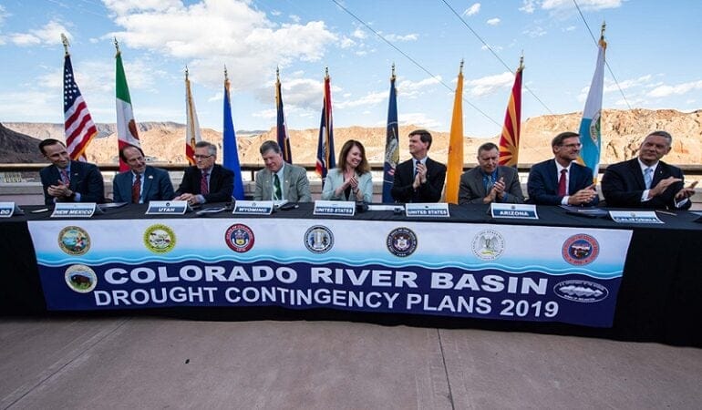
For nearly six years, representatives from the seven U.S. states of the Colorado River Basin were locked in intense, and occasionally fitful, negotiations over how to collectively weather the drought that has slowly strangled the river since the turn of the millennium. The laborious effort, which also involved officials from Mexico, stalled out for nearly two of those years due to particularly contentious local politics in Arizona and California. But in late May 2019, negotiators met atop Hoover Dam to sign a pair of so-called drought contingency plans with representatives from the federal government.
Under the plans, Arizona, Nevada, and California—which have long operated near or above the limit of their legal allocation of Colorado River water—agreed to progressively cut back on their water use if the drought deepens. That will slow the drop in water levels at Lake Mead, the enormous reservoir impounded behind Hoover Dam. The official sign-off on the plans also triggers commitments made by Mexico to implement its own water conservation measures, which will ultimately help water users in the U.S.
But the drought contingency plans, which remain in effect until 2026, are most important because they buy the Colorado River states seven years to come up with a potentially more ambitious plan for tackling the twin challenges that threaten the river over the remainder of this century: climate change and overallocation.
The drought contingency plans are “critical to getting through 2026,” says Terry Fulp, who oversees Colorado River operations for the federal Bureau of Reclamation in Arizona, Nevada, and California. “We had to reduce our risk. The worst place we could be is trying to negotiate a longer-term agreement in the middle of a crisis.”
Among water managers, it’s been no secret that the negotiators of the original agreement between the states about how to divide the river—the 1922 Colorado River Compact—parceled out rights to far more water than the river can reliably provide. For three-quarters of a century, however, there was more than enough water to go around. But increased pressure on the river from a surge in population, and from the now 20-year-long “millennium drought,” have laid bare the illusion that this waterway can support unfettered growth.
The acknowledged but previously largely theoretical problem of overallocation is suddenly becoming very real—and is only being made worse as climate change eats away at streamflow and reservoir levels. Nowhere are the stakes clearer than in Arizona. Under the terms of the drought contingency plan, the state will have to reduce its use of water from Lake Mead by 192,000 acre-feet in 2020—the equivalent of nearly 7 million semi-truck tankers. (An acre-foot is the amount of water it takes to cover one acre at a depth of one foot.) Ultimately, the burden of those cuts will largely fall on central Arizona farmers, and the effort to soften the blow for them proved to be the single most complex and contentious element of the entire DCP negotiation process. Next year, Nevada will also face an 8,000 acre-foot cut, and Mexico has committed to reducing its use by 41,000 acre-feet. Arizona’s cuts are so much larger because it holds a larger allocation of Colorado River water than either Mexico or Nevada, and the Central Arizona Project allocation has the lowest legal priority on the entire river.
The bitter struggle within Arizona provides a glimpse of how hard representatives from each of the states will have work to apportion pain among their respective constituencies during the next round of negotiations. The hard reality is that much bigger cuts will be the only way that the seven U.S. states— and Mexico—can reliably reduce the risk of keeping their shared water system from completely bottoming out.
“On the Colorado River, where you’ve got a shared management responsibility between seven U.S. and two Mexican states, plus two national governments, there are very different interests and very different views of how the system should be managed, and even very different views of some of the fundamental legal requirements,” says Jim Holway, director of the Lincoln Institute’s Babbitt Center for Land and Water Policy. Holway adds that the Babbitt Center is involved with a collaborative effort to engage and empower the 29 federally recognized tribes in the basin to participate in the next round of discussions. Although tribes are key players in the region’s water-rights equation, they have historically not had a seat at the negotiating table.
Going forward, the ultimate question is how much pain the seven U.S. states in particular are willing to endure. Will they continue the process of incremental adjustments to the so-called Law of the River—the conglomeration of agreements and treaties that dictate how the resource is managed—or finally double down on comprehensive reform?
With preparations for the next round of negotiations beginning while stakeholders are still catching their breath from the last one, this much is clear: For more than a century, the Southwest’s leaders have seen the Colorado River as an engine to maximize regional growth. It’s finally time, Holway says, “to maximize our ability to live within the system.”
Matt Jenkins has been covering the Colorado River since 2001, primarily as a longtime contributor to High Country News. He has also written for The New York Times, Smithsonian, Men’s Journal, Grist, and numerous other publications.
Photograph: Federal and state officials celebrate the signing of the Colorado River drought contingency plan atop the Hoover Dam in May 2019. Credit: U.S. Bureau of Reclamation.
