
This feature is adapted from Nature and Cities: The Ecological Imperative in Urban Design and Planning, edited by Frederick R. Steiner, George F. Thompson, and Armando Carbonell (Lincoln Institute of Land Policy, November 2016).
During the past 400 years, the land known as the United States of America has been transformed by massive public and private works projects and technological innovations intended to facilitate commerce, improve public health, and foster economic development. While these projects generated tremendous wealth for the nation, the gains were often to the detriment of the environment. The global realities of climate change—in combination with growing urbanization and associated poverty—have raised awareness of the ecological impact of such infrastructure. Americans are now at a unique moment in history when politics, economics, ecology, and culture (design) can all be part of a new movement. We need a WPA 2.0.
The WPA is the Works Progress Administration (1935–1943)—the largest and most ambitious program of U.S. President Franklin D. Roosevelt’s New Deal during the Great Depression. Much of the present-day infrastructure in the United States was built by either the WPA or the similarly named PWA (Public Works Administration). Almost every city, town, and community in America benefited from a new WPA- or PWA-built airport, bridge, dam, park, road, school, or other public building.1
Let me now reflect, albeit briefly, on the history of public works projects in the United States to discern where the world’s richest nation is, today, in terms of its urban infrastructure. This will allow a glimpse into how landscape architects, architects, and planners are addressing the needs and opportunities that face not only American cities, but communities and cities throughout the world as they confront the pressing realities of global climate change.
Canals and Harbors
Early settlement in the United States showed patterns of towns and cities directly related to water resources. Navigable waterways, safe harbors, and access to fresh water for fire prevention, sanitation, power production, farming, and drinking were central to the development of major commercial centers. Construction of the Erie Canal (1817–1825), for example, made New York the financial capital of the world during the nineteenth century by opening up critical supply lines for timber, furs, minerals, and agricultural products that helped the North win the American Civil War (1861–1865). Since then, we have seen the gradual decoupling of urban transportation systems from the physical environment in the United States.
The Grid
Looking back to nineteenth-century America, ideals of Manifest Destiny and the agrarian myth fueled a need to organize and cultivate the nation’s western frontiers. The Land Ordinance Act of 1785 was a resolution written by Thomas Jefferson (1743–1826), then a delegate from Virginia, to create a federal system for the survey and sale of federally owned land west of the Appalachian Mountains, intended to fund the federal government at a time when the government could not raise fiscal resources through taxation.2 It was then that an uncoupling of environmental and development systems started to take place on a large scale: The public land survey system parceled land into gridded territories, townships, and sections without regard to the geomorphology or carrying capacity of the property. Territories (24 x 24 miles; 38.624 x 38.624 kilometers), townships (6 x 6 miles; 9.656 x 9.656 kilometers), and sections (1 x 1 mile; 1.609 x 1.069 kilometers) were numbered and organized boustrophedonically, an alternating pattern from the top right to the bottom left quadrant of a square, similar to the path a farmer might follow when plowing a field.3
Agriculture, Railroads, and the Grid
When Horace Greeley (1811–1872), the famous editor of The New York Herald Tribune, purportedly declared in an editorial (13 July, 1865), “Go West, young man, go West and grow up with the country,” he rallied the nation.4 Greeley was responding, in part, to the Homestead Act of 1862, which enabled veterans, freed slaves, and even women to file a claim to a half-section of land (640 acres; 260 hectares) if they agreed to live on it and improve it for five years, further promoting agrarian values that were part of an American nationalism, which developed during a time of rapid industrialization. Manifest Destiny and agrarian culture, as characterized decades earlier by de Crèvecoeur (1735–1813) in numerous books, mythologized farming, espousing rural life as the foundation of character.5 However, the gridding of America and subsequent development of national rail lines—enabled by government grants of more than 300 million acres (121,405,693 hectares) to rail companies—were not reliant on natural systems for their development; instead, both worked in opposition to the waterways and topography they encountered, some of them extreme.
Supremacy over the landscape had its limits. While rail lines could be drawn to previously inaccessible corners of the country, facilitating commerce, they required long, gradual grade change and abundant clean water to function, limiting universal access. Farms and towns located themselves on and near new rail lines, but land in more arid climates west of the 100th meridian did not have the carrying capacity characteristic of Thomas Jefferson’s Virginia.6 Parcels of half-sections needed to be combined and annexed to enable productive use for timber or cattle grazing, uses that have their own heavy impacts on indigenous landscapes. The scale of operations moved toward a more standardized practice, away from the ideals of the rural farm. Western settlers and transcendentalists alike thought nothing of the consequences of introducing nonnative plant communities to the detriment of the indigenous environment.
A hallmark of the Industrial Revolution in the United States was the first transcontinental linking of rail lines—the Union and Central Pacific Railroads at Promontory Summit in Utah Territory near present-day Brigham City—on 10 May, 1869. Infrastructure tied to natural systems for the first two and a half centuries of the nation’s development could now follow a much more flexible path. By 1910, there was a network of more than 250,000 miles (402,336 kilometers) of rail covering the United States. Coeval with this infrastructural growth, the nation’s waterways transitioned from being critical economic lifelines to convenient disposal sites. As Carolyn Merchant has observed, “In the United States, industrial chemicals and wastes, including sulfuric acid, soda ash, muriatic acid, limes, dyes, wood pulp, and animal byproducts from industrial mills contaminated waters in the Northeast.”7 Ongoing pollution of rivers, canals, and ports still leaves neighboring communities managing the consequences of years of environmental abuses, despite the benefits of the 1972 Clean Water Act.
As natural systems became less important for access, they remained critical for raw materials. The relationship between water rights and rail lines, for instance, was critical not only because clean water was necessary to power steam engines, but also because the relationship between agriculture and rail transport systems opened up new areas of the country for the development and trade of commodities such as corn and wheat, legacy crops to this day.
Combined Sewers
When English plumber Thomas Crapper (1836–1910) popularized the use of the flush toilet during the 1860s, he surely had no idea of the potential future impact upon municipal watermanagement systems. His work triggered a cascade of events leading to the degradation of global waterways 150 years later. Rapid urbanization in the United States during the nineteenth century created the need for collective management of sanitary waste. In search of innovation, the United States looked to Europe, where a new form of infrastructure—the combined sewer—was developed to manage increased sanitary waste coming from more flush toilets. Combined sewer overflows (CSOs) release a witch’s brew of surface-water runoff and sanitary sewage into neighboring waterways when there is too much effluent for treatment plants to manage. Today, New York City, like 772 U.S. cities, has a combined sewer system where—in even a light rain—sanitary and storm wastes combine, releasing excrement, prophylactics, oil, pesticides, and heavy metals into New York’s harbor and rivers.
Around the world the combined sewers that unite sewage and stormwater in a common pipe—once a transformative infrastructure solution—have reached their limit. Growing urban populations and increased impermeable surfaces perpetually overload the sewage-treatment systems in cities globally. With sewage ever more frequently overflowing into waterways and a rise in sea level further compromising the outfall systems, policy makers and even private funders need to empower designers to rethink the design and management of urban stormwater and sanitary water systems. More severe and frequent storms resulting from global climate change will increasingly affect the hardened, postindustrial waterfront. Innovative urban design that can dissipate the forces of storm surge, manage flooding, reduce surface-water runoff, and reduce a heat-island effect need to be worked into an adaptation plan for waterfront cities. Without major changes to technology, the natural and human resource management of global health and productivity will be compromised.
The New Deal
Beginning in 1933, during the depths of the Great Depression, political leaders in the United States put forward programs under the New Deal that offered targeted relief for the massive number of unemployed and poor Americans, gradual recovery in the economic sector, and reform of the financial system. Significantly, New Deal programs also transformed the nation’s critical infrastructure. Roads, water-management structures, and pathways for electrification provided access, sanitation, and power to formerly undeveloped areas of the country. Parks, public buildings, bridges, airports, and other civic projects followed. Under President Franklin D. Roosevelt, the WPA employed millions of unemployed people, including women and minorities, constructing a renewed cultural identity for the nation.
A hallmark of the New Deal programs—valued at $20 billion (more than $347 billion at current value)—was the work of artists, writers, landscape architects, architects, and other creative professionals who helped shape the look and cultural literacy of the country during the twentieth century. Legions of laborers guided by designers and bureaucrats worked locally with a regional palette of materials to create extraordinarily beautiful yet practical work that reflected national pride and civic awareness. The work was modern and aspirational and showcased indigenous character and material. President Roosevelt understood the need for large-scale government action to help get the country back on its feet and headed in a new direction.
The Federal Highway System
Two decades later, in the aftermath of World War II and the Korean War, President Dwight D. Eisenhower signed the Federal-Aid Highway Act of 1956 into law. Also known as the National Interstate Defense Highways Act, the transcontinental highway system was presented to the public as essential to national defense systems and was funded at a cost of $25 billion through a tax on gasoline and diesel fuel. The term “infrastructure,” which developed during World War II to describe military logistical operations, became one of the president’s most visible and longlasting initiatives in the form of the U.S. interstate highway system. Eisenhower, the five-star general and supreme commander of Allied forces in Europe during the war, admired the efficiency of the German autobahns and sought to create a similar system in the United States. The unified design standards for the nation, consistent with the tenets of modernism, suggested the potential of technology to overcome geophysical obstacles in the landscape with hard engineering. The project catalyzed the development of sprawling new mega-regions of the late twentieth century.
Uncoupling
The sociologist and philosopher Jürgen Habermas (b. 1929), in his 1999 essay “The Uncoupling of System and Lifeworld,” suggested that the processes of differentiation and specialization inherent to modernism are undemocratic and that a democratic system of leadership in advanced capitalistic societies such as the United States enables decision making that is unreflective of society’s broader voice:
But political domination has socially integrating power insofar as disposition over means of sanction does not rest on naked repression, but on the authority of an office anchored in turn to legal order. For this reason, laws need to be inter-subjectively recognized by citizens; they have to be legitimated as right and proper. This leaves culture with the task of supplying the reasons why an existing political order deserves to be recognized.8
Through a democratic system, leaders are empowered to make massive decisions about the shape of their country with what I might characterize as “blind faith” in paternalistic power, which, when coupled with postwar fear and fatigue, is further enhanced. Technology reigned in the post–World War II period, and American culture was such that an uncoupling of the systems (such as interstate highways) from the life-world (the social and physical environment)—when presented by a war hero turned president—carried the necessary balance of paternalism and idealism to enable political support for the largest public works project in U.S. history.
As repressed groups, stifled by modernism’s systems-based approaches, found voice in the later twentieth century, the need for “different voices” (to borrow Carol Gilligan’s term) infused culture.9 The women’s movement, civil rights movement, and modern environmental movement each lent local and personal voices against the unsupportable rationality of current power structures. For the environmental movement, this contributed to important legislation such as the Clean Air Act of 1963 and the Clean Water Act of 1972.
The Problem
Many of the projects completed during the New Deal era are at the end of their lifespan. As James L. Oberstar has concluded:
Nearly sixty years after much of the interstate highway system was constructed in the 1950s and 1960s, we are now seeing many facilities become stretched to the limit of their design life and beyond. The world-class surface transportation system passed on by previous generations of Americans has reached the age of obsolescence and now needs to be rebuilt.10
Many canals and harbors are no longer used for commerce with the same intensity they once were, and they are, in many cases, decayed, underutilized, polluted, and subject to rising sea level and storm surge. Less than half of the original 300,000 miles (482,803 kilometers) of rail corridors across the United States are still in use for rail.11 America’s 772 cities have combined sewers that still dump significant amounts of sewage effluent into waterways. Highways and bridges are in similarly poor condition. The repair and replacement of these monumental infrastructure systems in their current configurations do not reflect social, environmental, and technological advances that have occurred during the last half century.
Every four years, the American Society of Civil Engineers issues a report card on America’s infrastructure. Here are the grades given in 2013 and 2009:
| Categories | 2013 | 2009 |
|---|---|---|
|
Aviation/Airports |
D | D |
| Bridges | C+ | D |
| Dams | D | D |
| Drinking Water | D | D- |
| Energy | D+ | D+ |
| Hazardous Waste | D | D |
| Inland Waterways | D- | D- |
| Levees | D | D- |
| Ports | C | (N.A.) |
| Public Parks and Recreation | C- | C- |
| Rail | C+ | C- |
| Roads | D | D- |
| Schools | D | D |
| Solid Waste | B- | C+ |
| Transit | D | D |
| Wastewater | D | D- |
| Overall Grade | D+ | D |
D = Poor; C = Mediocre; B = Good.12
An unprecedented combination of deeply troubling environmental problems, political evolution, and new design and technology now present an unparalleled opportunity to improve America’s infrastructure. Given the realities of global climate change and increased urbanization and population growth, interdisciplinary teams of thinkers must develop models of urban design that work with the hydrologic, transportation, ecologic, economic, and cultural systems that will make cities better-performing and more compelling places to work, live, and raise families. It is unclear whether this work will be driven primarily by the federal government, as it is in France or the Netherlands, or through the public-private partnership models common in the United States. The crucial role of design in the public realm is undervalued and attitudes need to change.
Understanding how physical geography, ecology, and climate function is critical to the development of new types of infrastructure that are more responsive to the forces of nature. The idea of using natural systems to provide public amenities and health benefits is not new. Frederick Law Olmsted (1822–1903), for example, used tidal flows to reduce pestilence and pollution in his design and plan for the Back Bay Fens of Boston during the late 1880s. With advances in technology in the aftermath of the Industrial Revolution, engineered solutions were seen as superior to historical precedent. Viewing infrastructure as a machine was the answer. As we observed in the aftermath of Hurricanes Katrina (2005), Irene (2011), and Sandy (2012), engineered systems are inflexible and can fail with catastrophic consequences as the severity, frequency, and intensity of storm events increase.
It is time to rethink the nineteenth- and twentieth-century engineering model and consider options that can again work in concert with the natural environment. Roads were traditionally aligned with rivers in many rural areas because they were cheaper to build, but roads and bridges in Vermont were destroyed in minutes by the flood-swollen rivers during Hurricane Irene. In metropolitan New York, highways, train yards, tunnels, and public housing located in floodplains along the postindustrial waterfront, where the land was cheap, were severely flooded during Hurricane Sandy in 2012. Replacement of New Jersey’s PATH trains and rebuilding of flooded tunnels and other public and private property in areas subject to more frequent inundation is costing taxpayers hundreds of millions of dollars a year when states of emergency are declared so frequently. Miami sits on a permeable bed of limestone at the interface of saltwater and freshwater and faces frequent hurricanes and flooding from upland and coastal sources that threaten not only its major industry—tourism—but also the ecological health of the Everglades.13
In many cities across the United States, combined sewer systems were an economical solution to sanitary engineering until climate change and population growth changed the balance sheet. Today, designers and public officials often look to Europe for water-management technology. American municipalities first looked at examples of combined sewers in France and Germany, and they now look to the Dutch for flood control. The Netherlands translates literally to “low lands,” and its strategy of planning includes 200 years into the future (long term), while constantly reconstructing dikes, dams, and polders (short term) is seen as necessary to protect not only the built environment, but also the agricultural economy dependent on sweet water (the Dutch term for fresh nonsaline water). In the United States, municipalities need to look further to the future and realize there are real opportunities to develop new innovations based on the nation’s geographic diversity. The prominent American geographer Gilbert F. White (1911–2006), in addressing the 1934 national flood-control policy, suggested that the multi-billion-dollar program to build reservoirs, canals, levees, and deeper river channels did not reduce flood losses decades later. In his words:
By assuming that only engineering works were needed to curb the cost of unruly streams, other possibly effective means were neglected. Little or no attention was paid to such alternatives as land use regulation or flood-proofing of buildings. By assuming the engineering works would do what the benefit-cost calculations had solemnly estimated they would do, without attempting to verify the practical results in land use, the public reaped quite different effects.14
America’s reliance on water-management structures thus provides a false sense of security in relation to availability, cost, and protection from catastrophic flooding. White suggested further that the “single purpose levee may set a confident scene for later catastrophe; a single-purpose reservoir may appropriate a unique dam site without assuring complete reduction in flood losses.”15 In many of White’s essays—written over a period of 60 years as a professor of geography and esteemed government advisor on natural hazards and flooding—he advocated a more holistic approach to design and planning and a testing of applied technology to gauge effectiveness.
Solutions
We know that gradual, buffered waterfront edges and barrier islands can dissipate wave energy, contain saltwater inundation, and make habitat that also helps to sequester carbon. The function of barrier reefs, salt marshes, and cypress swamps can thus inspire new models for an ecosystem’s management. Planning and designing for the periodic swells of rivers and streams may well necessitate an incentivized plan such as Zone (A)ir to relocate homes, towns, roads, communities, and businesses. It is critical that we adapt the architecture (buildings) and landscape architecture (infrastructure and outdoor space) by rethinking the porosity of the landscape, the materials of construction, the relocation of mechanical systems, and access. To the point: Our roads can soak up water, our highway trenches can be covered with parks that clean the air and provide recreational space, our waters’ edges can have an alternating combination of hard edges to facilitate commerce and softer edges to protect valuable upland real estate. Key to all of this thinking is the interface between human occupation and the environment.
The beginnings of this work in ecological design and planning are already apparent in Chicago, Philadelphia, and Portland, Oregon, where sidewalk swales and porous paving are becoming part of the standard streetscape. New York City is also taking on pilot projects to test the effectiveness of new materials and ideas, but testing takes time when action is needed. In floodplains along the Mississippi River, communities with low populations are being relocated and spillways opened to flood farmlands so that population centers downstream are safer. We cannot contain the force of water, as we once believed. Long-term, large-scale planning and actions that reduce our impact on the land, work in concert with natural systems, and enable new systems of exchange are necessary if we are to lessen the impacts of nature’s force.
Gilbert White long ago suggested a holistic and integrated regional approach to sound water management, but his voice fell on deaf ears, as single-purpose engineering solutions to local problems were constructed without consideration of watersheds and “sewersheds.” As towns and cities now work to manage aging infrastructure that is unable to handle impacts of more frequent storms and a rising sea, they have a huge opportunity to embrace new thinking and technology that, more than four decades after the federal Clean Water Act became law, will ameliorate day-to-day and storm-related wastewater loads with new and holistic gray/green engineered approaches.16 The costs of new infrastructure are real: Presently, approximately $95 billion will be needed to mitigate combined sewer overflows to bring cities in compliance with the 1972 law. Simultaneously, hundreds of billions will be needed to protect communities and cities against future flooding. Resources to address these issues should be combined for cost-effectiveness and efficiency.
Expansion of new green infrastructure networks—where hard surfaces are removed, utilities are protected, and stormwater is channeled for the irrigation of public parks, gardens, and wetlands—can also help mitigate and absorb floodwaters. Green (nature-based) infrastructure systems allow us to rethink not only the overarching functions of infrastructure, but also our experience of nature in the city. Municipalities have an opportunity to design and plan in the most comprehensive and cost-effective manner. The survival of towns and cities that currently exist at or just above sea level depends on aggressive, widespread rethinking of infrastructure for resilience to climate change and destructive storms. As we know, even if all 196 nations honor the commitments each made in Paris, in December 2015, to mitigate the effects of climate change, the global sea levels will rise at least 3 to 4 feet (0.914 to 1.219 meters) within a century, and all areas along the world’s coasts with elevations under 15 feet (4.572 meters) are extremely vulnerable to high tides and storm surge.17
WPA 2.0: A New Natural Infrastructure System
In response to the 285 deaths and widespread devastation (more than $50 billion in damage) caused by Hurricane Sandy (2012), three levels of U.S. government—federal, state, and local— established commissions, task forces, special initiatives, white papers, 12-point plans, plenary panels, and waterfront revitalization programs, all with vaguely military overtones that would convey action and strength. But will anything come of their recommendations? How can their ambitious designs and plans for modifications and improvements to make our city, state, and national infrastructure resilient to regular and extreme weather impacts be financed? To mitigate and counter the effects of an aging and ill-equipped infrastructure, to prepare now for global climate change, and to finance a new resilient defense network, I propose WPA 2.0 as a timely and much-needed solution.
The new infrastructure needed to adapt the nation’s cities, communities, and rural countryside to the realities of flooding and global climate change will require reconstruction on a massive scale of both gray and green infrastructure systems. Traditional, inflexible “gray” engineering approaches—which require waterproofing of transit systems, tunnels, and utilities or redirecting water with levees, dikes, and barriers—will work better in tandem with more resilient, ecological “green” approaches, including using currents and wind to distribute sediment for new barrier islands, reusing dredge materials to create shallows for wetlands, redesigning streets to absorb and filter stormwater, propagating a range of aquatic plants to make an ecologically rich buffer to storm surge, expanding natural flood zones (and buying out the people and businesses in them) that also function as parks most of the time, taking stormwater from highways and capturing sheet runoff in sponge parks, among other stormwater-capture systems.
As noted earlier, during the Great Depression, President Franklin D. Roosevelt’s New Deal programs brought sturdy, high-quality, and beautiful designs to public infrastructure with a national expenditure of $20 billion at a time when the gross domestic product was only $73 billion. The programs created millions of jobs, helped to restore economic stability, and offered financial reform to a flawed banking system. The Tennessee Valley Authority (TVA) was the largest New Deal enterprise. It was formed to harness and manage waterways of the Tennessee River watershed in seven states, create a public utility, and direct numerous resources to an impoverished region of the nation. Along with water management to prevent annual flooding and to manage navigation, President Roosevelt’s signing of the TVA Act created dams for the production and delivery of lower-cost electricity in an era when private utility companies were seen to be exploiting already financially stressed customers. And while the TVA was an electric utility that harnessed the power of water to deliver power, by the 1950s it added coal-burning power plants and, by the 1970s, nuclear power plants to deliver more power to meet growing demands. Energy production is at the root of global warming.
The need for greater urban climate resilience is a consequence of global warming, and emissions from combustion are a primary source. According to the U.S. Environmental Protection Agency (EPA), created in 1970 by executive order of President Richard M. Nixon, power plants, refineries, and chemical manufacturing accounted for almost 84 percent of total reported emissions of carbon dioxide, methane, nitrous oxide, and fluorinated gases in 2013.18 A modest tax on the companies that are responsible for the majority of climate-affecting pollution, including electric utilities, auto companies, oil companies, and other industrial polluters, could yield revenues necessary to create a Natural Defense Fund and finance a plan for climate change–resilient infrastructure for the next century. The idea of taxing carbon is not new. A tax on the largest carbon emitters and water polluters could bankroll a fund dedicated to urban and rural climate resilience. And the corporations can afford it: Even with energy prices at historic lows, the 10 largest power utility companies, for example, reported sales of more than $17 billion in 2014, and in the Fortune 500 list the top 10 oil refining companies alone had profits of nearly $67 billion in 2015.
In 2014, the U.S. government authorized nearly $50 billion to repair the damages from Hurricane Sandy. Although no monies were created for new defense systems, President Barack Obama included $1 billion in his 2015 budget for a climate-resilience fund. This was a good start. In fiscal year 2015, the Federal Highway Budget included $48.6 billion for repairs of an infrastructure system nearing the end of its designed lifespan. In the next two decades, cities across the country will need to spend at least $100 billion to clean up stormwater runoff and to reduce combined sewer overflows (CSOs) to comply with the Clean Water Act of 1972. It is unlikely that either local communities or the federal government will come up with the funds needed from taxpayers. Thus, by applying a minor tax on the industries whose practices have led to global climate change, a Natural Defense Fund can be created. If a related Natural Infrastructure System had the funding equivalent to the WPA of the New Deal, there would be a level of funding for resilient public works for the next century and beyond that would actually make a difference. As with the efforts to fight wars or help the nation recover from the Great Depression, a major program of renewal and development of the nation’s infrastructure will ensure the survival of cities, towns, and rural areas and lead to tens of thousands of permanent jobs in the public and private sectors, in the design, building, and maintenance of a new infrastructure for stormwater alone.
In 2005, I founded DLANDstudio, an interdisciplinary design firm based in Brooklyn, New York, where we have been developing systematic interventions and adaptations of urban infrastructure that address many of the issues described above. The work, funded with a combination of grants and public funding, involves pilot projects that are relatively small in relation to the enormity of the problem. The idea behind them is to find small pilots that, when applied on a broad scale, can have a large impact. Our projects are mostly in New York, but our planning stretches around the world. One of our most important projects is the Gowanus Canal Sponge Park, which operates to absorb, hold, clean, and filter surface water in one of the most polluted bodies of water in the United States.
Gowanus Canal Sponge Park
The Gowanus neighborhood of Brooklyn, New York, has a rich history. Originally a large marshy wetland, the area was the site of early Dutch settlement, important Revolutionary War battles, and industry, including the energy and construction sectors. In recent decades, the canal has been better known for the lingering effects of industrial pollution and municipal waste.19
Planners today envision the area as a new site for large residential development, a controversial proposal in the face of projections of a rising sea level from climate change. In this context, working closely with local community organizations, government agencies, and elected officials, DLANDstudio initiated and designed a new kind of public open space called Sponge Park™.20
In New York City, 0.10 inch (2.54 millimeters) of precipitation (especially rain) triggers a combined sewer overflow. The Hudson and East rivers, New Town Creek, Long Island Sound, Jamaica Bay, and Gowanus Canal are some of the key bodies of water impacted by these spills. Sponge Park™ redirects, holds, and treats stormwater runoff to minimize the volume of overflows that occur within the Gowanus Canal, and it serves as a model for similar street-ends that sheet-drain into canals, rivers, and other bodies of water in cities everywhere.
The Sponge Park™ design equally values the aesthetic, programmatic, and productive importance of treating contaminated water flowing into the Gowanus Canal, an EPA Superfund site. The park is designed as a working landscape that improves the environment of the canal over time. This innovative plan proposes modular strategies to divert stormwater runoff for use in the public park along the canal, thereby reducing the input of stormwater into the sewer system. The plants and engineered soils included in our design draw heavy metals and toxins out of contaminated water.
While most urban infrastructure projects have their challenges, the Sponge Park project had to confront not only geomorphic layers, but also layers of bureaucracy. We had to work with no fewer than nine different federal, state, and city agencies, each with overlapping ownership and regulatory oversight. As part of our creative response to those challenges,DLANDstudio raised all of the design and construction funding for the project from the New York State Council on the Arts, U.S. Congress, New York City Council, New England Water Pollution Control Commission, New York State Department of Environmental Conservation, and New York State Environmental Facilities Corporation. Through the use of grant funding, we were able to innovate in a way that would be impossible through normal procurement procedures. Because the project was seen as a pilot and was led by an outside entity but with the cooperation of government, we were able to create an innovative and replicable system. The first street-end absorbs 2 million gallons of stormwater per year. If Sponge Parks were built on every street-end in New York’s five boroughs, upward of 270 million gallons of water would be absorbed and cleaned before entering New York Harbor.
Hold System
Highway Overpass Landscape Detention Systems, or HOLD Systems, collect and filter stormwater from highway downspouts. HOLD Systems are planted, modular, green infrastructure systems that absorb and filter pollutants such as oil, heavy metals, and grease out of contaminated outfalls, rendering runoff much cleaner as it is released into drains and waterways. The system’s ability to retain water during heavy rain also improves the water quality of adjacent bodies of water. Plant palettes selected for each site help to break down or absorb copper, lead, cadmium, hydrocarbons, zinc, and iron commonly found in runoff. Specially calibrated soils maximize plant productivity and create the ideal level of drainage for citywide stormwater management needs.
HOLD Systems are designed for easy transport and deployment, and they can be quickly and easily installed in hard-to-reach, hard-to-drain areas along interstate highways. HOLD Systems can remediate the impact that a highway infrastructure makes on the hydrologic cycle of neighboring areas. Three modular systems—two in the ground and one above ground—have already been developed by DLANDstudio to adapt to water-table height, permeability, site toxicity, and the availability of sun. These systems are currently being deployed in three locations in New York City—two in Flushing Meadows–Corona Park under the Van Wyck Expressway and one in the Bronx under the Major Deegan Expressway—with funding and other support from the New York City Department of Environmental Protection, Long Island Sound Futures Fund, and the National Oceanic and Atmospheric Administration.
MoMA: “A New Urban Ground”
“A New Urban Ground” was developed by DLANDstudio with ARO (Architecture Research Office) of New York City, as part of the Museum of Modern Art’s (MoMA) “Rising Currents” exhibition in 2010. In the proposal, we offered an integrated and reciprocal organization of natural and hard-infrastructure systems. A combination of strategies—including wetlands on the perimeter, a raised edge, and sponge slips (water-management landscapes in old boat slips)—were paired with new street infrastructure systems away from the water’s edge in order to protect Lower Manhattan from flooding in the event of another large storm such as Hurricane Sandy, which was but a Category One hurricane when it hit the New Jersey, New York, and Connecticut shores.
The proposal consists of two components that form an interconnected system: porous green streets and a graduated edge. Porous streets will absorb typical rain events and help keep surface water out of the city’s combined sewer system. In larger storms, the streets filter and carry water to new perimeter wetlands to enrich coastal ecologies.
Three interrelated, high-performance systems are constructed on the Atlantic Coast to mitigate the expected rise in sea level and the force of a storm surge: a park network, freshwater wetlands, and brackish marshes. “A New Urban Ground” offers a new way for urban design and planning that brings together natural ecologies with engineered infrastructure systems to transform the city in both performance and experience. This plan, which was proposed almost two years before Hurricane Sandy flooded Lower Manhattan, Staten Island, Red Hook, and the Rockaways, has been cited internationally as a viable model for new civic approaches in resilience to storm surge and sea level rise.21
BQGreen
Highway infrastructure systems across the United States are designed for one primary purpose: to move people and goods quickly from one place to another. But, as a society, it is time to rethink this singular, limited view and consider how infrastructure systems can also become productive corridors of beauty, culture, ecology, and recreation. The BQGreen project considers one such corridor—the Brooklyn-Queens Expressway (BQE)—and examines in depth two sites along its 11.7-mile (18.829-kilometer) length.
The BQE was originally proposed by the Regional Plan Association during the mid-1930s to relieve traffic congestion, facilitate industrial development, and strengthen the connection between the boroughs of New York City. The BQE differed from the city’s other parkways by accommodating both commercial and noncommercial traffic. City planner Robert Moses (1888–1981), as the chairman of the Triborough Bridge and Tunnel Authority, charted its path from the Brooklyn Battery Tunnel near Red Hook to Grand Central Parkway in Queens. Construction of the BQE left a trail of divided neighborhoods in its wake.
We know from examples such as Riverside Park (1875 and 1937) in Manhattan, a hybrid Olmsted- and Moses-era park constructed on a concrete box over a major rail corridor, that it is possible to layer transportation with extraordinary public parks. Density is an urban concept that is tied to economics. As the land that infrastructure systems occupy becomes more valuable, it makes sense to layer. As environmental impacts and benefits begin to be assessed in economic terms, the value of making significant alterations to our roadways becomes more attractive at a time when America’s highway infrastructure is near the end of its lifespan and in need of significant repair. As these old systems are replaced, why not reexamine them and consider how they might serve economic, ecological, recreational, public health, and pedestrian-friendly circulation needs in addition to transportation?
Since 2005, DLANDstudio has examined two sunken sections of the BQE. The project began on a theoretical level with a grant from the New York State Council on the Arts to look at tiny Cobble Hill and Carroll Gardens before expanding to study a very different neighborhood in SouthSide Williamsburg, with funding from then City Councilwoman Diana Reyna. The latter study went into great detail about the economic, social, and public health consequences of adding a park to the impoverished neighborhood. Extensive community outreach included visits to neighboring playgrounds, church events, and performances to make sure we recognized the voice of the community. Data were developed regarding the financial feasibility of capping costs—including ventilation and structural costs—as well as analysis of job creation, real estate value, and even the bump in retail sales at neighboring bodegas. We studied public health issues and discovered very high asthma and obesity rates as well as a relative dearth of open recreational space for kids in the vulnerable preadolescent stage. We discovered gang territories defined by the trench and imagined blurring the boundaries with new soccer and baseball fields. We helped the community to dream and then engaged the agencies to help fulfill that vision, with formal support for the proposal from New York City’s Departments of Transportation, Environmental Protection, and Parks and Recreation. Outreach to Congressional Representative Nydia Velázquez and U.S. Senator Kirsten Gillibrand also yielded positive support. To realize this vision will take the collaboration of city, state, and federal agencies; through the master plan we are making a strong argument for why this is the right project for all to support, as we work to make our communities and cities more efficient, livable, and environmentally productive.
The insertion of quality open space has the capacity not only to improve the aesthetics of neighborhoods, but also to serve as a catalyst for ecological and economic improvements to the urban environment. This project establishes a vision of the BQE as a place of opportunity where new open space can be created by introducing an environmental and recreational corridor and turning a former eyesore into a public amenity.
QueensWay
Already, 20,000 miles (32,187 kilometers) of abandoned rail corridors have been turned into bicycle and pedestrian greenways across the United States.22 The QueensWay Vision Plan, commissioned by the Trust for Public Land (TPL), a nonprofit organization founded in 1972, is one of TPL’s several current national initiatives to transform former rights-of-way in cities into active and engaging community greenways. The project involves the conversion of a former Long Island Rail Road line into a new open-space corridor for the public.
The history of land development in Queens is largely defined by the numerous rail lines that subdivided open tracts of land during the late nineteenth and early twentieth centuries. The QueensWay appropriates one of these infrastructural lineaments to opposite effect, as a unifying device. Each of the three main segments of the QueensWay—northern, central, and southern—possesses a distinct physical character that creates unique staging opportunities for the interaction of urban and natural space. Along its 3.5-mile (5.633-kilometer) length, the former right-of-way transforms from an elevated embankment to a ravine to an elevated steel viaduct. The adjacencies along the QueensWay also vary, with Little League baseball fields along the northernmost end; big-box-store parking lots, residential neighborhoods, and a public park in the middle; and crossing train lines, commercial corridors, and parking lots to the south. Issues such as safety, security, and the privacy of adjacent properties are directly tied to how the former railway line moves through the urban landscape. A quiet presence in the city, camouflaged by school-bus parking, overgrown vines, light industry, and limited access, the QueensWay has the potential to be a beautiful recreational and ecological amenity for the community.
The Future
John Wesley Powell (1834–1902)—among America’s greatest geologists, scientific surveyors, and explorers—in his famous 1878 “Report on the Lands of the Arid Region of the United States,” called for a clearer understanding of the climate and carrying capacity of the American Southwest, recognizing that not all landscapes and their capacities for human development are the same:
To a great extent, the redemption of all these lands will require extensive and comprehensive plans, for the execution of which aggregated capital or cooperative labor will be necessary. . . . It was my purpose not only to consider the character of the lands themselves, but also the engineering problems involved in their redemption, and further to make suggestions for the legislative action necessary to inaugurate the enterprises by which these lands may eventually be rescued from their present worthless state.24
Powell wrote at a time when massive changes and their resultant impacts upon the American landscape were only beginning to be understood. We are at a similar stage in history when global climate change and an overall recognition of the impacts of people on the natural environment are yielding potentially catastrophic consequences. Powell, Gilbert White, and Jürgen Habermas, writing in different eras, all called for the integration of disciplinary and social thinking about our interaction with the physical world, beginning with the inherent, natural capacities of an environment to perform. Though they approached issues from different perspectives, they also understood a need for a multivalent, interdisciplinary approach to our occupation of the planet that involves ecological, economic, sociological, and artistic metrics.
The unprecedented and unrepeated investment in the American landscape during the New Deal and post–World War II periods provides replicable models from which to develop new systems of infrastructure that will help ameliorate the impacts of urbanization and climate change. New technologies and approaches to infrastructure that value working with natural systems can help create systems that grow stronger and more resilient over time. Collective will, new financing models—public or private—and strong leadership are needed to make WPA 2.0 a natural infrastructure system that can reduce human impact on the global biota.
Susannah Drake is the founding principal of DLANDstudio Architecture and Landscape Architecture, whose “Rising Currents New Urban Ground” proposal is in the permanent collection of the Museum of Modern Art and Cooper-Hewitt Design Museum. Since 2005, she has taught at Harvard, IIT, FIU, CCNY, Syracuse, Washington University in St. Louis, and The Cooper Union. Her work and writings have appeared in National Geographic and The New York Times, and she has contributed to Infrastructural Urbanism (DOM Publishers, 2011), Under the Elevated (Design Trust for Public Space, 2015), DEMO:POLIS (Akademie der Künste, 2016), and Nature and Cities: The Ecological Imperative in Urban Design and Planning (Lincoln Institute of Land Policy, 2016).
Drawing courtesy of DLANDstudio Architecture + Landscape Architecture, PLLC.
1. The WPA and the PWA were both New Deal programs during the Great Depression. Despite their similar-sounding names, they have critical distinctions: First, WPA laborers were hired directly by the government, while the PWA contracted much of their work to private entities. Second, the WPA engaged primarily in smaller projects with local governments such as schools, roads, sidewalks, and sewers, while PWA programs included large-scale bridges, tunnels, and dams. See: Leighninger, Robert D. “Cultural Infrastructure: The Legacy of New Deal Public Space.” Journal of Architectural Education, Volume 49, No. 4 (May, 1996): 226–236.
2. Carstensen, Vernon, “Patterns on the American Land,” Publius: The Journal of Federalism, Vol. 18, No. 4 (Fall 1988): 31–39.
3. Stilgoe, John R., Common Landscape of America, 1580 to 1845 (New Haven, CT: Yale University Press, 1983), 104.
4. The origins of this famous phrase about Manifest Destiny in America are disputed. Fred R. Shapiro, the editor of the Yale Book of Quotations, comments on the origins in the Yale Alumni Magazine (September/October 2008); see http://www.archives.yaleulumnimagazine.com.
5. See, for example, de Crèvecoeur, J. Hector St. John, Letters from an American Farmer (London, UK: T. Davies, 1782).
6. See Hudson, John C., Plains Country Towns (Minneapolis: University of Minnesota Press, 1985), which won the first John Brinckerhoff Jackson Book Prize of the Association of American Geographers.
7. Merchant, Carolyn, The Columbia Guide to American Environmental History (New York, NY: Columbia University Press, 2002), 112.
8. Habermas, Jürgen, “The Uncoupling of System and Lifeworld,” in Elliott, Anthony, ed., The Blackwell Reader in Contemporary Social Theory (Oxford, UK: Wiley-Blackwell, 1999), 175.
9. Gilligan, Carol, In a Different Voice: Psychological Theory and Women’s Development (Cambridge, MA: Harvard University Press, 1982).
10. Oberstar, James L., special comments in LePatner, Barry B., Too Big to Fall: America’s Failing Infrastructure and the Way Forward (Lebanon, NH: Foster Publishing, in association with the University Press of New England, 2010), xi.
11. Tracy, Tammy, and Hugh Morris, Rail-Trails and Safe Communities: The Experience on 372 Trails (Washington, D.C.: Rails-to-Trails Conservancy, 1998); available online at http://www.railstotrails.org/resources/documents/resource_docs/Safe%20Communities_F_lr.pdf.
12. See http://www.infrastructurereportcard.org.
13. See, for example, Kolbert, Elizabeth, “The Siege of Miami,” The New Yorker (December 21 and 28, 2015): 42–46 and 49–50.
14. White, Gilbert F., “The Changing Role of Water in Arid Lands,” in Kates, Robert W., and Ian Burton, eds., Geography, Resources, and Environment: Vol. 1, Selected Writings of Gilbert F. White (Chicago, IL: University of Chicago Press, 1986), 137.
15. Ibid.
16. As defined by the EPA, “gray” infrastructure is “conventional piped drainage and water treatment systems” and “green” infrastructure is “designed to move urban stormwater away from the built environment [and] reduces and treats stormwater at its source while delivering environmental, social, and economic benefits.” See EPA, “What is Green Infrastructure”; available at https://www.epa.gov/green-infrastructure/what-green-infrastructure.
17. See, for example, Ganis, John, with essays by Liz Wells and James E. Hansen, America’s Endangered Coasts: Photographs from Texas to Maine (Staunton, VA: George F. Thompson Publishing, 2016).
18. See http://www3.epa.gov for an update.
19. See Alexiou, Joseph, Gowanus: Brooklyn’s Curious Canal (New York, NY: NYU Press, 2015).
20. For an overview of Sponge Park, see Foderaro, Lisa W., “Building a Park in Brooklyn to Sop Up Polluted Waters: Site Will Treat Thousands of Gallons near Canal,” The New York Times (December 16, 2015): A27 and A29.
21. See, for example, Palazzo, Danilo, and Frederick R. Steiner, Urban Ecological Design: A Process for Regenerative Place (Washington, D.C.: Island Press, 2011), 6; and “Rising Currents: Projects for New York’s Waterfront to Respond to Climate Change,” Landscape Architecture China, Vol. 11, No. 3 (June 2010): 70–75.
22. The origins of the rails-to-trails movement was brilliantly presented by Charles E. Little in his now-classic book, Greenways for America (Baltimore, MD: The Johns Hopkins University Press, in association with the Center for American Places, 1990).
23. Carbonell, Armando, Mark Pisano, and Robert Yaro. 2005. Global gateway regions. September. New York, NY: Regional Plan Association. http://www.america2050.org/pdf/globalgatewayregions.pdf.
24. Powell, J. W., “Report on the Lands of the Arid Regions of the United States, with a More Detailed Account of the Lands of Utah” (Washington, D.C.: Government Printing Office, April 2, 1878), viii.
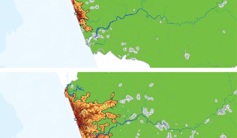
Cities around the world seem to be stretching out physically and consuming land at a rate that exceeds population growth. As populations double, land use triples.
When city growth comes up in public discourse, the conversation almost invariably focuses on population. We speak of “booming” cities that have grown from, say, 2 to 5 million in just a few decades or declining cities that are hollowing out and losing residents at a rapid rate.
The common unit of understanding and measurement, in other words, is almost always the number of people. Measures of land use are often missing from the picture, despite the fact that cities grew much more in land use than in population between 1990 and 2015, according to data from the UN-Habitat Global Urban Observatory. In developed countries, urban population grew 12 percent, while urban land use increased by 80 percent. And in developing countries, population expanded by 100 percent while urban land use rose 350 percent.
Land use issues will become more critical as the world population exceeds 9 billion and 2.5 billion persons migrate to cities by 2050, according to the United Nations’ projections. Configuring urban areas and their available resources to support this massive inflow will be critical to sustaining human life on the planet, says George W. “Mac” McCarthy, president and CEO of the Lincoln Institute.
It’s a profound area of concern: How exactly are these rising urban populations changing global maps? Further, can we observe regular, even predictable, patterns? And are these trend lines, such as they are, sustainable over time?
To date, there has been little scientific understanding of broad global patterns related to how city borders, systems, and land-use patterns are changing. But the newly revised, second edition of the online Atlas of Urban Expansion, first published in 2012, aims to fill this crucial gap in knowledge. Produced through a partnership among UN-Habitat, the New York University Urban Expansion Program, and the Lincoln Institute, the new Atlas performs very precise analysis of satellite imagery, coupled with population figures and other data, to study the changing nature of cities observed from 1990 to the present. The full report and data are set to be unveiled this October at the Habitat III global cities summit in Quito, Ecuador, as part of the implementation of the UN’s New Urban Agenda.
The new Atlas analyzes 200 cities (up from 120 in the 2012 sample), rigorously selected from among the 4,231 cities in the world with populations greater than 100,000 (as of 2010) that constitute a representative sample of large urban areas. The 200 cities in question make up about 70 percent of the world’s urban population.
The United Nations statistics division has now accepted and adopted this “UN Sample of Cities” as a way to conduct ongoing analysis of urbanization trends. “Cities, how they form, and the effects of urbanization on the quality of human life must now be treated as a science,” says Joan Clos, executive director of UN-Habitat, during the launch at UN headquarters in New York in June 2016: “The unprecedented confluence of climate change, population boom, and the rush to live in cities means that our critical human development will take place in cities.”
With unplanned settlement fluidly redefining many urban boundaries, it is crucial, experts and planners say, to produce a consistent method for studying cities as contiguous spatial units, not just administrative jurisdictions. The UN Sample of Cities also enables transition from an urban agenda based on country-level data to one predicated on city-based data collection and analysis.
Studying such a sample allows us to infer some generalizable rules about large urban areas, notes Atlas coauthor Shlomo “Solly” Angel, a professor and senior research scholar at New York University. “The sample accurately represents that universe,” he says of cities with populations of 100,000 persons or more, “so you can actually make statements about that universe given information about the sample. That’s the more scientific contribution of this Atlas.”
Land Consumption and “De-densification”
What, then, can be said of the world’s large cities, now that such representative data have finally been collected and crunched?
One reliably observed pattern is that cities around the world seem to be stretching out physically and consuming land at a rate that exceeds population growth. This tendency corroborates the findings of the first-edition Atlas, which indicates “falling density.” In the past, this was termed “sprawl,” and some refer to it now as “de-densification.” In any case, for a planet increasingly concerned with sustainability, energy efficiency, climate change, and resource scarcity, this is not a good trend: Density generally allows for greener and more sustainable living patterns.
Angel notes that there is a kind of rough statistical rule that emerges from the new Atlas work: As populations double, land use triples. “Even though people would like to see densification increase or at least stay the same, it doesn’t,” he adds.
Many policy makers have been unable, or unwilling, to see this reality unfolding in recent decades. Don Chen, director of Equitable Development at The Ford Foundation, says that the issue of sustainable growth is “very uneven in terms of planning officials’ awareness.” In many countries, he adds, “various orthodoxies are battling it out,” and frequently the “cards are stacked against us” in terms of changing norms and official attitudes: “For many, many decades, and in some countries for centuries, there have been incentives [for] building on virgin land.”
And even where there is political will for change, there are “multiple dimensions of capability to build upward, such as in-ground infrastructure,” Chen notes. Wider complex systems must be coordinated from a policy perspective in order to achieve greater density and land conservation.
In any case, the data analysis effort undertaken in the Atlas—which at root is intended to help define a new “science of cities”—may serve as a wake-up call. Angel says the Atlas can be a “tool for convincing policy makers that the expansion they must prepare for is considerably larger than their own little back-of-the-envelope calculations, or what their planners have in their master plans.”
Increasing density again will necessitate sacrifice and modification of existing norms for living standards in many places: It will require people to live in smaller apartments and homes, in multifamily housing, and in higher buildings. It also will frequently require redevelopment of low-density areas in cities.
McCarthy acknowledges that the data are “a little bit chilling,” as they reveal a pervasive pattern that signals huge trouble ahead. “It’s something that we have to stop—whether we call it ‘sprawl’ or ‘de-densification’ or something else,” he says. “We can’t continue to consume all of our best land with urban development. We still have to feed ourselves. We still need to collect water.”
He also notes many ill-fated attempts to build large housing units far outside denser urban areas, leaving millions of units across the world largely empty. This has happened in many countries, from Mexico and Brazil to South Africa and China. “Why is it that we continue to build these developments in the middle of nowhere and expect people to live there?” McCarthy says, noting that it is vital to link jobs and industrial activity with housing.
Clearly, smarter, more proactive planning is required for growth across the world, the project’s researchers say. That means finding the right ways to channel city growth spatially and to create the infrastructure—transportation, water, sewer, and other necessities—so the new settlements and housing units are serviced appropriately.
Moreover, it is also necessary, Atlas researchers say, for many of the big cities around the world—from Lagos, Nigeria, to Mexico City to Zhengzhou, China—to adopt more next-generation thinking about so-called “polycentric” cities. That will require moving beyond the traditional paradigm of hulking, monocentric cities with a huge urban core and instead creating polycentric networked hubs, whereby a metropolitan area will have many interlinked urban centers.
Signatures of Unplanned Settlement
The satellite imagery analyzed in the Atlas also highlights other key patterns that are both drivers and/or symbols of the overall de-densification trend worldwide.
One very granular mark is the lack of four-way intersections, a clear sign that roads are being laid out haphazardly, in a largely unplanned way. Such informality and unplanned development have been increasing over time across the world. The pattern, however, is strongly correlated with lower GDP per capita, and therefore is more pronounced in the developing world and global South. Linked to this observed pattern is an increase in urban block size, as shantytowns and unplanned settlements of many kinds grow without regard to transportation needs.
Indeed, the Atlas also suggests a pervasive lack of orderly connections to arterial roads, which are key to facilitating transportation to employment and economic networks. Built-up areas within walking distance of wide arterial roads are less frequent than they were in the 1990s, according to data from that decade. And more generally, there is simply not enough land being allocated for roads.
In addition, low-density tracts and small dwellings are unnecessarily consuming precious urban open space—parks and green spaces that can make dense urban areas more livable.
Angel says planners need to get ahead of the coming wave of urban migration and secure land for transportation, affordable housing, arterial roads, and open space. That needs to be done before settlement happens, when land prices subsequently soar and the logistics of moving populations become trickier. “This can be done at a relatively small cost,” Angel notes. He suggests that planners begin to “make some minimal preparations for it.”
Even in countries where there is a high degree of central planning, the data contained in the Atlas may prove helpful for diverse land management challenges.
“Compared to most cities in the developing world, Chinese cities are better managed,” says Zhi Liu, director of the Lincoln Institute’s China program. “The Atlas is still useful for China, as it provides accurate, visual urban expansion data and analytics to planners that could strengthen their understanding of the scale and patterns of urban expansion in their cities.”
The Atlas Data Challenge
Behind the new analytical insights produced by the Atlas, an intriguing and important backstory of data collection and analysis highlights future challenges for urban theory and monitoring of global cities, especially in developing nations.
Alejandro “Alex” Blei, a research scholar in the urban expansion program of New York University’s Marron Institute for Urban Management, said that assembling the 200 cities for the representative sample was no easy task, as there is no universally accepted definition for a metropolitan area. Researchers had to account for variables such as regional location, growth rate, and population size in order to ensure the sample was representative, and they had to create a careful and defensible methodology.
NASA’s Landsat database, a satellite imagery program running since the 1970s, was the basis for the spatial analysis. While that methodical, scientific dataset is of exceedingly high quality, the underlying population data, which was key for establishing migration- and settlement-related patterns, was frequently less than perfect.
“Some countries have very well-established data programs,” Blei said. But in other cases the data are very “coarse,” and large cities, particularly in the developing world, have only broad census zones. It is therefore difficult, at times, to make fine-grained insights about population changes in connection with land use shifts, as the researchers had to assume equal density over large tracts of the metropolitan area in question.
Scanning the NASA pictures, the researchers had to analyze pixels to assess whether there was impervious coverage surface or soils. They performed this task with powerful software according to well-established methods, but correlating it with population data was not always smooth. “Unfortunately, there’s not very much we can do if the data are not very good, but we did the best we could under the circumstances,” Blei says.
Evidence suggests the need for less variation in population data collection and synthesis across countries, in order to derive more actionable insights for policy makers in every country. And more global consensus is needed around the definition of cities. The U.S. Census Bureau defines them very precisely as “urbanized areas,” or “metropolitan statistical areas,” but they are frequently defined in more scattered ways by other countries’ data collection agencies. Asia and Africa—home of many of the fastest-growing cities, both in terms of population and geographic extent—suffer from a lack of granular city population data that speak to neighborhood-level change.
Global Nuances and Uncertain Futures
The publication of the new Atlas will, of course, join a long debate in policy and academic circles about how to measure sprawl, both high- and low-density, and the best models for addressing related issues. The new Atlas also speaks to a long research literature on the consumption of resources and quality of life in urban contexts.
Enrique R. Silva, a senior research associate at the Lincoln Institute who has specialized in Latin American planning and governance issues, notes that the Atlas research will continue to help advance understanding of government planning and rule-making, as well as residential pricing. The 2016 Atlas project includes surveys conducted with various stakeholders in cities that might yield insights on planning policies and markets, among other issues.
“It’s definitely an effort that is needed,” Silva says. “It’s a first-mover type of project. The measure of success will be the extent to which other researchers, whether through critique or support of the initial idea, can improve upon it and contribute to our understanding of how cities are growing, or even contracting.”
It will also help ground-level understanding for those studying or making policy in particular cities. Silva points to a place like Buenos Aires, which he calls a “classic case” where the expansion of territory is occurring faster than the population growth—and where many people are being displaced outward from the denser city core. Silva says that research by his Lincoln Institute colleague Cynthia Goytia has shown how lax land use regulation affects settlement patterns. Land markets and their regulations affect affordability, and this can result in unplanned settlements, her research suggests.
Neema Kudva, an associate professor at Cornell University who is an expert in growth patterns in India and South Asia, also praises the “very careful work” performed in the Atlas effort. But she worries that smaller cities—those under 100,000 and therefore excluded from the analysis—may see different dynamics that are subject to more variable patterns and experiences.
In trying to create “one science of cities,” she says, we may miss significant differences between small and big metropolitan areas, limiting our ability to imagine creative interventions. “The difference between small and big can be the ability to influence political processes, the ability to garner funds, to organize, to intervene,” Kudva says. “For a person like me who is interested in smaller places, things like the Atlas provide important suggestions, important points of reference, important counterpoints, but they are not always useful.”
Kudva also wonders if large-scale, emerging changes related to energy systems, global warming, sea-level rise, and political upheaval may alter worldwide land use patterns, compared to those observed in the past. The issue of falling density is potentially reversible, she believes. “That trend could change,” she says. “We need to play a more interventionist role.”
Still, better data and a more detailed picture of settlement patterns can substantially help address challenges common to cities of many different sizes. Chen, of the Ford Foundation, notes that research like the Atlas is necessary to combat issues such as unequal access to opportunity. “We need baseline data, and we need to understand the relationship between how we use land and other things.”
The issue of global inequality, which McCarthy calls the biggest “unassailable challenge” of cities, looms in all of the data. Beyond the layers of the Atlas’s global maps are stubborn facts and dilemmas that researchers and policy makers are only beginning to understand and address. “The biggest one is the absolute concentration of poverty and geographic isolation of large segments of the population,” McCarthy says, noting that sometimes 30 to 50 percent of residents in many large cities live in “deplorable conditions.”
Decent affordable housing that is meaningfully integrated into the economic network and flow of cities has to be a priority. Yet many national efforts to date have failed to achieve that goal. “That’s the thing that I find most vexing,” McCarthy says.
As the new Atlas is rolled out in October at the UN-Habitat III conference in Quito, that issue—and many others affecting the world’s fast-growing cities—is sure to be framed even more precisely and powerfully by the new, comprehensive data.
John Wihbey is an assistant professor of journalism and new media at Northeastern University. His writing and research focus on issues of technology, climate change, and sustainability.
Image by New York University Urban Expansion Program

This month, like conquistadors of centuries past, tens of thousands of us will ascend the Andes to Quito, Ecuador, in search of El Dorado. But, unlike our brutal and greedy predecessors, we are not pursuing metallic wealth beyond our wildest dreams. The golden city we seek promises a sustainable urban future. Our map—the New Urban Agenda, which will be announced and adopted during Habitat III, the United Nations Conference on Housing and Sustainable Urban Development in October 2016—tells us where we are going, but it does not tell us how we will get there.
We know that we will encounter monumental challenges as we navigate this path to welcome some 2.5 billion people to the world’s cities over the next three decades. We will be tasked with providing jobs and housing for both these newcomers and current urban residents who are inadequately housed or underemployed. And we will have to make unprecedented investments in infrastructure to provide basic services for these new city dwellers. Our local governments will need to step up, as never before, to implement and finance measures to handle extraordinary growth. But while the bulk of responsibility for managing this last epoch of urbanization will fall on local governments, the rest of us are not off the hook. In fact, it is safe to say that the actions of other institutions—particularly national and subnational governments and certain NGOs—will determine whether urbanization succeeds. We will all need to pull together to find our way to larger, more inclusive, equitable, and sustainable El Dorados.
And here is how these golden cities will function. Local, provincial, and national governments will align and coordinate their actions to manage urban growth successfully. This sounds easy enough, but what will it mean in practical terms? It means that different levels of government will commit to getting urbanization right and adopt some new modus operandi. It means that higher levels of government will stop devolving expenditure responsibilities to lower levels of government without identifying or providing sufficient revenues to cover the expenditures. It means that national governments will provide local governments the statutory authority to raise their own funds to meet many of their own financial obligations. It means that we will ensure local governments have the capacity—both technical and human—to make efficient use of all available resources. And it means that national governments will commit to adapt and adjust their policies to match the changing needs of local governments and the contexts in which they work.
Powers conveyed and responsibilities mandated from higher levels of government to lower levels through constitutions and legislation will reflect strategic alignment. Resources transferred from higher government levels to lower levels through agencies or ministries will be less encumbered by earmarks or overbearing compliance rules. Local governments’ powers and responsibilities will be codified in constitutional and legislative “rules of the game” that define a better-groomed playing field. Rules that enable localities to manage their affairs—granting them the power to levy certain taxes and fees or the legal authority to enforce tax collection—will displace regulations that constrain the ability of localities to attend to their own needs, such as property tax rate limitations.
Playing by national rules will no longer be difficult or impossible for cities. Other municipal governments will follow Detroit’s lead and find ways to avoid leaving tens of millions of already-allocated federal dollars on the table as Detroit did in the years preceding its bankruptcy. They will seek assistance to overcome the staff deficits and technical limitations that led to Detroit’s failure to adequately manage federal funding, as noted in the 2015 Government Accounting Office (GAO) report. And they will not fault themselves for their inability to use that money; they will recognize that defects in the design of funding programs are to blame, given that many thriving cities are likewise unable to utilize all of their national funding. And they will know that their problems are not exceptions but rules, as hundreds of cities across the world acknowledge that efficient use, or under-use, of intergovernmental transfers is an almost insurmountable challenge. This is something that we will fix on our way to El Dorado.
But how will we detect and correct defects in the design of intergovernmental transfer programs? Where is the forum where rules of these games are reviewed and refined? It is not surprising that the GAO would conclude that the failure of federal funds to reach the ground is a problem of local capacity. How would the national government get enough objective distance to consider the idea that its programs and policies are ineffective because of bad design? National governments will create programs crafted to fulfill policy goals, not to frustrate local governments’ attempts to meet citizens’ needs. But how? To know whether their programs are working, they will talk about them with their local counterparts. Although these discussions rarely occur now, they will become commonplace. Productive feedback through honestly brokered conversations will ensure that the troops on the ground are on the same page as the legislature and its ministries. And vice versa.
And this is where other key institutions will play a role. Specifically, NGOs and quasi-governmental organizations will connect the work of policy implementers with policy makers. Some institutions are familiar with the work of local governments and trusted by them as partners, but they also have access to and credibility with national leaders and policy makers. These organizations can serve as honest brokers and conveners to bridge the communication gap between policy conception and implementation and help to improve both. Hundreds of these mediators, or “conversation conduits”—including multilateral funders and social-change philanthropists, think tanks and practice-oriented departments of universities, membership organizations of public officials and development lenders, and the Lincoln Institute of Land Policy—will work together to complete a “virtuous circle” that leads to better policies and aligns the efforts of multiple levels of government to achieve the goals of sustainable urbanization. And they will develop and deliver training and technical assistance to build the capacity of local governments.
It is a bold vision of the future. But without efforts like these, it is hard to imagine how we will achieve the goals of the New Urban Agenda. A significant share of the approximately 4,300 cities in the world with populations greater than 100,000 can use some help to grow their skills and systems, and to communicate better with higher levels of government. And many of them are hungry for the help.
We started on this path with the launch of our global campaign for municipal fiscal health two years ago at a congressional briefing where we were invited to talk about the challenges that perpetuate weak economic performance of older industrial American cities. We will follow next spring with a roundtable co-convened with the Pew Charitable Trusts (a fellow mediator) to present findings from a study of unspent federal grants that we have underway with planning students from Northeastern University (another mediator). We will invite representatives from federal agencies to explore the implications of the findings for reforming formula-funding programs. In addition, we have begun to design and offer training modules to build capacity and technical assistance for cities. But we need help—a lot of it.
Let’s take advantage of the Habitat III meeting to network the institutions that want to help cities make efficient use of intergovernmental transfers and other resources—through policy dialogues convened with national governments, or through capacity building programs for local governments, or both. This effort requires more resources and skills than any of us can mobilize individually. We need to tackle this challenge together. The Lincoln Institute is ready to participate in a global effort to empower cities to solve their own problems, and we will identify others to begin the process of mobilizing and coordinating a new global practice. Please seek us out in Quito if you want to learn more about what we are doing and how we might work together.
We will not get another chance to get urbanization right. By the middle of this century, 70 percent of humanity will reside in cities. We must ensure that they are the cities we need. Habitat III is a rare occasion when national governments focus on their urban centers and the outsized role they play in their nations’ futures. Let’s use this moment to focus our collective efforts to implement the New Urban Agenda in the next two decades, and travel together on the road to a new El Dorado.
Photograph by pxhidalgo / iStockPhoto

Holyoke, a city of about 40,000 in western Massachusetts, was one of the nation’s first planned industrial communities. Beginning in the late 1840s, Boston investors transformed what had been a farming area into a mill town, taking advantage of its location along the Connecticut River. The investors wanted to manufacture cotton textiles. But over time an elaborate canal system was built in the city to accommodate more and more mills, and the town became known for silk, wool, and paper manufacturing as well. In time, Holyoke came to be known as the “Paper City” because of its paper mills.
As the mills developed, the city prospered. With jobs plentiful, the town attracted successive waves of Irish, French-Canadian, German, Polish, Jewish, Italian, and Puerto Rican immigrants who worked in the mills, created small businesses, raised families, and built a city that reached a population of 63,000 by 1917 (McLaughlin Green 1939).
Then it all began to come apart—slowly. From a peak in the 1920s, local industry gradually declined as companies and jobs moved overseas or migrated to the South and West to be nearer raw materials and cheaper labor. By the time of the 2000 census, Holyoke’s population had shrunk to fewer than 40,000. Like other small industrial towns across the country, it was part of a fading era in the American industrial past, and the once-prosperous Paper City was fighting to keep its economic footing.
Fortunately, Holyoke had a big stroke of luck in 2009, when the city was selected as the site for what came to be known as the Massachusetts Green High Performance Computing Center (MGHPCC)—an environmentally friendly supercomputing complex intended to bolster what state officials call the Massachusetts “innovation economy.” Water power was once again key to the city’s success. Holyoke’s location on the banks of the Connecticut River offered access to low-cost hydroelectric power, while the river and the city’s many canals offered water for cooling, a major advantage in supercomputing. “Holyoke has struggled after losing its industry base,” says Kathleen Anderson, president of the Greater Holyoke Chamber of Commerce. “We had aging infrastructure that needed to be repurposed, loss of jobs, and other changing demographics. Holyoke had to think in creative ways and recognize the assets we had. Both human talent and the wisdom of acquiring the dam and its hydropower have been foundational to our rebirth.”
When the computer center opened in 2012, it represented an important first step toward improving Holyoke’s fortunes, but it wasn’t enough to restore its vitality. The city undertook a planning effort that produced a 20-year renewal plan to revitalize and redevelop the area where the MGHPCC is located, in the center of town. An important step in realizing the plan was the creation of the Holyoke Innovation District—an investment the state made through the Massachusetts Technology Collaborative that brought together local officials, business leaders, and community organizations to encourage local and regional economic development. “The attraction of the computing center to Holyoke really started our planning process around the Holyoke Innovation District. Really, we say it spawned out from the computing center,” Marcos Marrero, Holyoke director for planning and economic development and co-chair of the Holyoke Innovation District, said in a September interview (Desmarais 2015) with the Bay State Banner.
Leadership, Collaboration, Resurgence
That’s when the Boston Federal Reserve Bank entered the picture. Since 2008, the bank’s research staff had been studying older industrial cities like Holyoke as part of an effort to help revitalize another Massachusetts city, Springfield. Like Holyoke, it had seen better days. The bank conducted a two-year study partnership with Springfield that examined the challenges facing the state’s fourth-largest city, which continued to fail even as state government and nonprofits poured millions of dollars into revitalization.
One part of the study tried to glean lessons for Springfield from the fates of 25 other small industrial cities in the Northeast, Midwest, and upper South. The Boston Fed’s economists found that a handful of these cities had been able to either maintain or recover much of their economic stability, as measured by income, poverty rates, population, and economic vitality. Boston Fed researchers called them “resurgent cities,” and the researchers looked for common themes that explained their success. The cities, they found, faced similar challenges—poverty, changes in racial and ethnic makeup, and the loss of their manufacturing bases. But all were fighting through their challenges and shared a key driver of success: sustained leadership and collaboration among businesses, government, nonprofits, and community groups. “Time and again, our examination of the resurgent cities’ histories indicated that the resurgence involved leadership on the part of key institutions or individuals, along with collaboration among the various constituencies with an interest in economic development,” bank researchers wrote in a 2009 report (Kodrzycki and Muñoz 2009).
The bank researchers noticed that the source of local leadership varied from place to place. In New Haven, Connecticut, local colleges and universities worked with government officials and private industry to provide workforce training and funding to attract companies. In Providence, a nonprofit foundation worked with business executives to develop ideas and a consensus on downtown development projects. In Evansville, Indiana, a mayor initiated the turnaround in the 1960s, and it continued, thanks to an aggressive economic development campaign by the local chamber of commerce later on. Despite their differences, all these economic redevelopment efforts spanned decades, implying solid ongoing leadership.
All the efforts demonstrated the active collaboration of numerous groups and individuals as well. According to the Fed’s research, “Collaboration became necessary because economic transformation is complex, and because outsiders—such as state and national governments, foundations, and businesses that are potential sources of funding and jobs—often require proof of joint efforts in order to contribute to a city’s development.”
Rising to the Challenge
These findings led the Boston Fed to ask what it could do to help build the strong civic infrastructure that was critical to resurgence. The result was the Working Cities Challenge, which the bank created with the help of Living Cities, a New York–based collaboration of 22 foundations, financial institutions, and other partners.
The Challenge took the form of a competition among the smaller former industrial cities in Massachusetts. In the spring of 2013, 20 communities applied to participate. From the applicants, six cities were selected to receive a total of $1.8 million in grants to support projects that emphasize leadership and collaboration. Among the first six winners was Holyoke, along with Chelsea, Fitchburg, Lawrence, Salem, and Somerville. The goal was simple: to help save these struggling Massachusetts cities by supporting development of the tools they needed to help themselves.
The program was an important and unusual one for a federal reserve bank. The banks are better known for cranking out economic research than for mounting programs in the field. However, the initiative reflected Boston Fed President Eric Rosengren’s commitment to applying the bank’s economic research to the real world and to improving New England communities. And the concept is scalable, with nationwide potential to bolster cities and towns across the country that have struggled with 21st-century economic realities.
Tamar Kotelchuck, director of the Working Cities Challenge, says that the bank’s research on resurgent cities taught them that most struggling cities can do better. “Based on what we learned from studying resurgent cities, we got together with Living Cities and came up with the idea of a competition for multiyear funding to incentivize leadership and collaboration,” she says.
She says the bank decided to start with a pilot program in Massachusetts, with a focus on small and midsize cities. The target cities range in size from about 35,000 to 250,000 and share certain economic and demographic similarities, including a large number of poor families and low median incomes. “These cities had already formed a coalition to support their interests with the help of MassINC, a local think tank,” Kotelchuck says. “They called themselves Gateway Cities and had been working together on common economic and political problems for a few years. They had learned that working together gave them a certain amount of power that none had alone,” she says (Forman et. al. 2007).
Working Cities took a singular approach in attempting to help these cities, according to Andrew Reschovsky, a fellow at the Lincoln Institute. “What is unique about the Working Cities initiative is that, unlike many other urban economic development strategies, its focus is on improving the economic well-being of each city’s current low-income residents.”
The federal reserve banks can’t use their own funding to provide grants, but a number of willing partners stepped forward to aid Working Cities. Kotelchuck says the Fed’s role in the initiative includes designing and implementing the model in partnership with a steering committee, providing technical assistance, and helping teams build capacity through expert assistance, networking, and best practices. The grants are funded by several donors, including the state government; Living Cities; the Massachusetts Competitive Partnership, an association of the 16 largest employers in Massachusetts, focused on promoting economic growth; and MassDevelopment, the state’s development agency.
Kotelchuck says that when the bank and its partners put together the first competition in 2013, they left it up to the cities to propose how the grant funding would be used. “We didn’t tell cities what to work on,” she says. “The challenge is designed to help build collaboration around issues that are important locally.” A major requirement for a successful project, though, was that it should involve the private sector, government, and other local groups working together. “We were looking for projects that promoted systemic change,” she says. “Our goal was intended to help local leaders fix things in their cities.”
An independent jury evaluated the cities’ proposals based on criteria that reflect the Working Cities Challenge goals of collaboration, community engagement, and the use of evidence to track progress. The projects had to make a lasting contribution to improving the lives of low-income residents.
In January 2014, the first awards were announced. Of the six cities selected, four received multiyear grants, and two received seed awards. All the cities were combatting high unemployment, low student achievement, and an uncertain future. However, Kotelchuck says, “All the winning cities had distinctive proposals. No two were alike. They all addressed specific local needs, just as we had hoped,” she says.
For example, Fitchburg in north-central Massachusetts received a three-year grant of $400,000 for its eCarenomics Initiative—an effort to develop shared metrics for neighborhood health and well-being, with the goal of improving one part of town. Chelsea won a three-year grant for its Shurtleff-Bellingham Initiative, designed to reduce poverty and mobility rates by 30 percent in the struggling neighborhood. Salem received a $100,000 seed grant for its plan to bring one low-income neighborhood’s economic indicators in line with the rest of the city by focusing on economic development, small business development, workforce development, and leadership development. Somerville also received a one-year seed grant of $100,000 to support a workforce training program for out-of-school “youth” aged 18 to 24.
The largest single award, a $700,000 three-year grant, went to Lawrence in the northeastern part of the state. The award was for the Lawrence Working Families Initiative, whose goal was to create a Family Resource Center designed to increase the incomes of parents of local school children by 15 percent over a 10-year period. The initiative is led by Lawrence Community Works and the local school system, with support from several employers and nonprofits in the area. “The Lawrence school system had gone into receivership in 2011,” Kotelchuck explained, so focusing on families and schools was a logical choice.
The city also had economic characteristics that fit the Working Cities’ model. Its median household income was half the statewide median, and its poverty rate was almost triple the statewide rate. “The city’s population is 70 percent Hispanic, and unemployment was a problem,” Kotelchuck says. Many of the problems the city faced spilled over into the schools. “The goal of the Family Resource Center is to help families in as many ways as possible. It provides financial coaching, crisis support, and other services to strengthen families,” she says.
Beyond the family center, a large part of the initiative is focused on what Kotelchuck calls “authentic parent involvement” in the schools. The initiative created community education circles where parents, teachers, and students work on specific problems in the schools. “The goal is to get parent buy-in and involvement in the school system,” she says. So far, the program has involved 400 parents, hired a family coach, and placed more than 30 parents in jobs, according to Kotelchuck.
Holyoke received a $250,000, three-year award that is being used to implement SPARK (Stimulating Potential, Accessing Resource Knowledge). This downtown “entrepreneurship and social venture development center” aims to increase business ownership, particularly among the city’s residents, including the Latino population, which accounts for 60 percent of the population. The project team that created the program is made up of representatives from the city, the chamber of commerce, the Holyoke Public Library, a one-stop employment center called CareerPoint, and the local nonprofit Nuestras Raíces.
The SPARK program is “geared toward identifying, recruiting, and stimulating Holyoke residents and organizations that have a ‘spark’ or desire to move their innovative projects or business proposals from concept to reality by emphasizing a whole-community approach to entrepreneurialism, individual learning, and leadership training,” according to the city. In short, it’s designed to help prospective business owners establish business plans and figure out how to get operating.
Another goal is to tie members of the downtown Holyoke community into the Innovation District the city created around the supercomputing center. “The city has a big data center,” Kotelchuck says. “But that alone won’t necessarily help Holyoke’s low-income people. The question that SPARK addresses is how do you build upon the assets of Holyoke’s immigrant population and make sure people benefit from the development that’s going on around the innovation district.”
City officials agree. “This award is more great news for the future of the city’s Innovation District,” Mayor Alex Morse said when the grant was announced. “We’ve been working hard to position Holyoke to compete in the modern economy, which requires us to stimulate innovative projects and business ventures. With the collaboration of some of Holyoke’s finest organizations and community leaders, this funding will allow us to assist local residents in bringing their innovative ideas to fruition.”
Kotelchuck says that many cities try to attract young professionals and focus on tech jobs. They see other cities succeed using that model and copy it, but not always successfully. “If we don’t help low-income residents,” she says, “all we’re doing is moving poverty from place to place, and that helps no one. The Working Cities initiative helps people where they live. It helps people who wouldn’t otherwise have jobs.”
“Many cities chase the newest, flashiest strategy to revitalize themselves, but ultimately it’s not the newest trend that revitalizes a city,” she says. “It’s the effects of many ideas over time, and it only happens in cities with community engagement and collaboration. Our advice is to look at what you have and build systematically on it.”
She says that in monitoring the Challenge, she has noted differences in how cities think about their futures. “Some cities say: We have so many problems; give us some money,” she says. “But others say: We have these resources. We have some energy. We need help realizing our potential.” She says that revitalization efforts will require a decade of effort or more. The Fed’s goal is to provide a three-year leg up on the effort.
It can also spark broader interest in the cities’ revitalization. Recently, Holyoke SPARK received an additional $56,000 from the Massachusetts Growth Capital Corp., a quasi-public agency that supports small businesses, to help the program offer more classes, provide mentoring for entrepreneurs, and support a micro-enterprise loan program for those who qualify. It also received additional funding from the city’s Community Development Block Grant this year.
Signs of Progress
The Fed and its partners are happy with the project’s results so far, Kotelchuck says. And the bank recently announced a second and third round of grants, for cities in Massachusetts and Rhode Island. Eventually, she thinks the idea could spread to other Federal Reserve districts. “It’s a new model for Fed involvement in these communities. Other Feds are showing interest, and we would be delighted if it takes root in other districts.” Bank President Rosengren says that the Boston Fed plans to expand the program to other New England states at the very least.
The Working Cities program shows great potential to spread farther. Small cities and towns all over the country have been batted around by changing economic fortunes in recent decades. They deserve a chance at becoming resurgent cities too, and it’s gratifying to see an organization like the Boston Fed putting its brains and influence behind improving their future. There is no silver bullet, no guarantee of success, but the Working Cities Challenge shows that good things can happen with time, commitment, elbow grease—and a little money.
This point was underscored by the Lincoln Institute’s Reschovsky: “Although all the cities currently involved in Working Cities need more economic and fiscal resources, the key to the success of the initiative will be the combination of additional resources and the development and nurturing of local nonprofit, government, business, and social institutions.”
That certainly seems to be the case in Holyoke. Lately, it has even developed a little national “buzz.” In the February issue of Popular Mechanics magazine, the editors designated the nation’s 14 best startup cities, saying they wanted to identify “the next wave of cities building an ecosystem to turn innovators into entrepreneurs.” The list features smaller cities from across the country. Holyoke made the list at number six (Popular Mechanics 2015).
Inevitably, the city’s chief advantage is a familiar one. “We have cheap energy,” Mayor Morse wrote in a description of innovation in Holyoke for the magazine. “On the city’s eastern border, the Connecticut River drops 57 feet as it presses south. When the city was founded, in 1850, the river powered waterwheels for paper mills; today it generates inexpensive, clean energy.” He also mentioned the brick paper mills, signs of the industrial past that have been repurposed as “attractive industrial work spaces.”
“Holyoke has gone back to where we started,” the Chamber’s Anderson says. “Our ancestors dug a canal system to harness power, and now we are still harnessing it as green energy to power a new economy.”
Billy Hamilton is executive vice chancellor and chief financial officer of the Texas A&M University System. He was for 16 years the deputy comptroller of public accounts for the State of Texas. Since 2007, he has written a weekly column for State Tax Notes.
Photograph by Jeffrey Byrnes
References
Desmarais, Martin. 2015. “The Holyoke Innovation District Finds Creative Solutions to Revitalizing the City.” The Bay State Banner. September 10, 2015. baystatebanner.com/news/2015/sep/10/holyoke-innovation-district-finds-creative-solutio/?page=3
Forman, Benjamin, David Warren, Eric McLean-Shinaman, John Schneider, Mark Muro, and Rebecca Sohmer. 2007. Reconnecting Massachusetts Gateway Cities: Lessons Learned and an Agenda for Renewal. The Brookings Institution and MassINC. February 2007.
Kodrzycki, Yolanda and Ana Patricia Muñoz. 2009. “Lessons from Resurgent Cities.” Federal Reserve Bank of Boston. 2009 Annual Report. www.bostonfed.org/about/ar/ar2009/lessons-from-resurgent-cities.pdf
McLaughlin Green, Constance. 1939. Holyoke, Massachusetts: A Case History of the Industrial Revolution in America. New Haven, Connecticut: Yale University Press.
Popular Mechanics. 2015. “The 14 Best Startup Cities in America.” Popular Mechanics. February 2015. www.popularmechanics.com/culture/advertorial/g1859/the-14-best-startup-cities-in-america
Since 1978, the Chinese government has pursued various economic and housing reforms to expand private property rights in housing and to promote home ownership through the commercialization and privatization of urban public housing. This has involved terminating the old system of allocating housing units through public-sector employers and establishing a more market-based system of housing provision. The government now provides affordable housing by subsidizing commercial housing purchases or by offering low-rent public (social) housing to middle- and low-income families. At the same time, it relies on the private commercial housing market to meet the needs of higher-income groups.
Recent Housing Reform and Outcomes
China’s housing policies experienced a drastic change in 1998 when the central government ended direct housing distribution to employees through the former danwei or employer-based system. According to government plans, the affordable housing system targeted at middle-income households was established to provide support to nearly 70 percent of urban families. It also introduced housing cash subsidies to new employees and set up a Housing Provident Fund—a compulsory housing savings system to provide subsidized loans to employed homebuyers. Low-rent public housing is provided by the government to low-income urban households, while commercial housing is provided by the market to meet the needs and demands of high-income families at the top 15 percent of the economic spectrum that have access to mortgage financing (Wang 2011).
This housing reform has resulted in a vigorous and fast-growing urban housing market and greatly improved housing conditions for urban residents. For example, the floor area per capita in urbanized areas increased from 6.7 square meters in 1978 to 28.3 square meters in 2007, and the home ownership rate reached to 82.3 percent in urban China in 2007 (Man, Zheng, and Ren 2011).
However, with urban housing prices skyrocketing since 2005, housing affordability has become a major issue in a number of large cities, and municipal governments have been called upon to increase the provision of affordable housing to middle- and low-income households. Government policies have been implemented in an attempt to stabilize urban housing prices, to discourage speculative behavior of homebuyers, and to reduce both the excessive lending practices of state-owned banks and the possible financial risks associated with the housing sector.
Urgent Need for Affordable Housing
Affordable housing is often defined as an adequate dwelling where less than 30 percent of monthly household income is devoted to rent, or where the dwelling’s purchase price is less than three times a household’s annual income. The housing price-to-income ratio (PIR) is the basic affordability measure for housing in an urban area. It is generally defined as the ratio of the median house price to the median family income. In the Global Urban Observatory Databases of UN- HABITAT, PIR is one of the important urban indicators, and a ratio between 3 and 5 is considered normal or satisfactory. In the United States and Canada, the PIR is 3.2 and 3.5, respectively, which meet the international standard for a normal or affordable level of housing (Demographia 2009).
Our study used the Large-Sample Urban Household Survey data collected by the National Bureau of Statistics of China to calculate the PIR in 2007 for urban China, and found it to have a value of 5.56 nationwide (Man, Zheng, and Ren 2011). This ratio falls in the category of “severely unaffordable” according to the criteria proposed by UN-HABITAT, and is well above the normal range of 3 to 5. It indicates that the median price of the housing stock in the sample of 600 Chinese cities (based on the survey of 500,000 urban households) is more than five times annual household median income.
The Current Situation and Challenges
Affordable housing is often measured in terms of median values and incomes, but the concept is applicable to both renters and purchasers in all income ranges. Affordable housing in China, commonly known as “economical and comfortable housing,” is designed to be available to middle- to low-income households, including public-sector employees, to encourage home ownership.
In general, the Chinese central government sets polices and mandates with respect to affordable housing, and the subnational governments, cities in particular, are responsible for the construction, financing, and management of that housing. The central government does not provide financial support to provincial and local governments for affordable housing through its budgetary spending or intergovernmental transfers, except for a few subnational governments in the fiscally strained and underdeveloped central and western regions.
Local governments are required to provide free land, reduce government charges and fees, and control developers’ profits to lower the housing price for those who are qualified based upon government eligibility standards. In some cities, such as Beijing, affordable housing also includes price-controlled commercial housing whose price is held down by the provision of reduced land use fees and charges, as well as favorable land allocation by the government to help lower- and middle-income families become homeowners. The Housing Provident Fund, a compulsory saving plan with contributions by both employers and employees for housing purposes, helps employees buy a house with subsidized loans.
Local governments provide state-owned land to affordable housing projects through appropriation mechanisms. They usually appropriate land to developers who finance, construct, and sell the economical and comfortable housing units to the people considered eligible according to government standards and regulations. Middle-income families seeking market-oriented commercial housing may receive a subsidized loan from the Housing Provident Fund. With housing prices lingering at levels inaccessible even to average salary earners, the current affordable housing system has encountered a number of serious challenges.
First, there is an enormous and growing demand for affordable housing in China. By the end of 2008, there were about 7.4 million low-income urban households in need of government support for housing (Lin, forthcoming). In addition, government population and labor statistics indicate that cities have an estimated “floating population” of 147 million, most of whom are migrant workers who often fall within the low-income group. At the current rate of urbanization, there will be an increase of about 10 million people in cities every year. Most of them will be unskilled and semi-skilled workers in the low- and middle-income levels in need of housing assistance.
Second, affordable housing accounts for only a small portion of the total housing stock, underscoring inadequate government support for middle- and low-income households in urban China. Our research reveals that government-sponsored low-rent housing, as well as heavily subsidized economical and comfortable housing, accounted for only 7 percent and 4 percent of the total housing stock on average in urban areas, respectively (figure 1). In contrast, the two most prevalent types of housing are commercial housing (32 percent) and privatized public housing (34.2 percent).
Among the 256 prefecture-levels cities we studied, the median share of the total housing stock that was affordable housing was 5.57 percent. One-third of the cities had less than 5 percent of affordable housing in the total housing stock, indicating a seriously inadequate supply of affordable housing for low- and middle-income urban households. The underdeveloped private rental market in China further aggravates this problem.
Figure 2 reveals that investment in economical and comfortable housing has barely increased in contrast to the rapid rise of investment in commercial housing during the period between 1997 and 2007. The completed floor area of economical and comfortable housing as a share of the total decreased between 1999 and 2007, contributing to the chronic shortage of affordable housing in large cities. In addition, the eligibility criteria is either too high or the enforcement is problematic. As a result, figure 3 shows the coverage of affordable housing is overly broad, benefiting more high- and middle-income families than lower-income households, and thus causing accusations of corruption and calls for reform.
Third, local governments in China lack incentives and financial means to provide affordable housing. The fiscal reform of 1994 left subnational governments with the obligation to provide nearly 80 percent of total government expenditures, but with direct receipt of only 47 percent of total government revenues (Man 2010). Such fiscal imbalances, plus many unfunded central government mandates and expenditures related to interjurisdictional competition, have driven many local governments to rely on land leasing fees for revenue to finance infrastructure investment and economic development.
Local governments prefer offering state-owned land to the highest bidder among developers through the auction process to maximize revenue, and they have little incentive to provide land for the construction of affordable housing for low- and middle-income families. In addition, the financing of affordable housing in China depends upon funds from the Housing Provident Fund, but its deposits come from sources such as fees from land transfers that are unstable and inadequate to sustain affordable housing investment.
According to a recent report of the Chinese National Auditing Office (CNAO 2010), some cities, including Beijing, Shanghai, Chongqing, and Chengdu, have failed to collect the 10 percent of funds from the net profit of land transfer fees earmarked for low-rent housing construction as required by government regulations. A total of 14.62 billion yuan (about US$2.2 billion) was not collected during the 2007–2009 period, accounting for about 50 percent of the total 29.68 billion yuan (US$4.47 billion) that was due, according to CNAO’s survey of the 32 major cities.
Finally, the current affordable housing system in China is targeted only at urban residents who have city residence permits as part of its household registration system (commonly known as the hukou system). Migrant workers, floating populations, and others without urban residence permits are not covered. These people have to find shelter in the informal housing market, such as urban villages with substandard living and sanitation conditions.
Furthermore, this system suffers from poor administration, widespread corruption, and even fraud. For example, many ineligible applicants have received low-rent housing, and a number of high-income households own government-subsidized economical and comfortable housing units. At the same time, many qualified families have been denied housing assistance.
Conclusions
The rapidly rising housing prices and lack of affordable housing for low- and middle income urban households in China, particularly in big cities, have posed risks and challenges for a stable and harmonious society as sought by the Chinese central government. The current issues and challenges in the affordable housing system warrant attention and support from the Chinese government and the entire country to search for cost-effective and equitable public policies to deal with affordable housing needs to ensure sustainable development and a harmonious society in the future.
The government needs to redouble efforts to curb speculative housing activities, increase land supplies for affordable housing construction, and use fiscal policies and tax incentives to encourage private developers to participate in the provision and management of affordable housing. Moreover, China should establish an efficient and effective local public finance system and a modern property tax to diversify local government revenue sources. This would help reduce reliance on the leasing of public land for revenue and would encourage the supply of more land for low- and middle- housing. Chinese governments also should accelerate the development of private rental markets and encourage the private sector and nonprofit organizations to participate in the construction, financing, and management of housing for middle- and low- income families.
About the Author
Joyce Yanyun Man is senior fellow and director of the Program on the People’s Republic of China at the Lincoln Institute; director of the Peking University–Lincoln Institute Center for Urban Development and Land Policy in Beijing; and professor of economics in the College of Urban and Environmental Sciences at Peking University.
References
Chinese National Auditing Office (CNAO). 2010. Audit report on 19 municipalities and provinces for government-invested affordable housing during the period 2007 to 2009. No. 22. http://www.audit.gov.cn/n1992130/n1992150/n1992500/2596931.html
Demographia. 2009. The Fifth annual Demographia international housing affordability survey. http://www.demographia.com/dhi.pdf
Lin, Jiabin. Forthcoming. The design of China’s affordable housing system. In Low-income housing in China: Current issues and policy design. Beijing, China: Commercial Press.
Man, Joyce Yanyun. 2010. Local public finance in China: An overview. In China’s local public finance in transition, eds. Joyce Yanyun Man and Yu-Hung Hong. Cambridge, MA: Lincoln Institute of Land Policy.
Man, Joyce Yanyun, Siqi Zheng, and Rongrong Ren. 2011. Housing policy and housing markets: Trends, patterns, and affordability. In China’s housing reform and outcomes, ed. Joyce Yanyun Man. Cambridge, MA: Lincoln Institute of Land Policy.
Wang, Ya Ping. 2011. Recent Housing Reform Practice in Chinese Cities: Social and Spatial Implications. In China’s housing reform and outcomes, ed. Joyce Yanyun Man. Cambridge, MA: Lincoln Institute of Land Policy.