New Book “Infrastructure Economics and Policy” Offers an Essential Guide to Smart Public Investment
By Lincoln Institute Staff, Diciembre 15, 2021
SHARE
Editor’s Note: This article was adapted from “Investing for the Future,” published July 22, 2021.
As governments consider major infrastructure proposals, the Lincoln Institute has published a new book that will help policy makers achieve a greater return on public investments. Edited by José A. Gómez-Ibáñez and Zhi Liu, Infrastructure Economics and Policy: International Perspectives includes contributions from 30 leading international academics and practitioners on topics such as project appraisal, financing, governance, climate change, and technology.
The book comes out at a time when governments of many countries are considering infrastructure as a policy instrument to stimulate national economies that have been adversely affected by the COVID-19 pandemic. The book offers case studies, data, and analyses that can help governments evaluate infrastructure proposals.
It includes the following six takeaways to consider in any infrastructure investment package, based on extensive research into the ingredients for success:
Think Long-Term Growth, Not Quick Stimulus. Contrary to conventional wisdom, infrastructure investment is not an effective way to provide a quick economic stimulus. It takes many years to secure the permissions and funding necessary to begin construction on a new project, and the sophisticated equipment and training required by modern construction means such projects do not offer pathways to quick employment for large numbers of unskilled workers. Infrastructure Economics and Policy explains why infrastructure investments offer few short-term impacts, even when the long-term economic impacts are clearly positive.
Shovel-Worthy Matters, Not Shovel-Ready. The impacts of infrastructure projects depend greatly on their quality. Many infrastructure agencies are required to prepare cost-benefit analyses of the major projects or policies they are considering and of the relevant alternatives to those projects. However, few governments (if any) require the agencies to adopt the alternative with the highest net benefit. This is often because of political considerations, including concerns that cost-benefit analysis might not adequately reflect the goals of fairness and equity. While cost-benefit analyses are not perfect, they are one of the best tools available for evaluating infrastructure proposals, and agencies should be cautious about departing significantly from the option with the highest net benefit without good reason.
Beware of Over-Confidence and Over-Optimism. A landmark analysis of some 2,000 infrastructure projects found that actual costs were significantly higher than forecast, while usage was significantly lower, as Bent Flyvbjerg and Dirk W. Bester explore in a chapter of the book. The authors identify several well-known behavioral limitations that lead to these outcomes, particularly overconfidence bias and optimism bias. Fighting these biases is difficult because they are so deeply ingrained in human nature, but the book describes measures that can help, such as holding forecasters legally accountable or using independent audits.
Take Equity Seriously. The costs and benefits of infrastructure projects are often distributed inequitably. On the one hand, major infrastructure facilities such as highways and power plants are often built in locations where the negative impacts are felt disproportionately by low-income residents and people of color. On the other hand, the lack of access to basic infrastructure, particularly in the developing world, impairs quality of life and contributes to inequality. Governments need to take both problems seriously and enact complementary policies to address them.
Consider Governance Challenges. State and local governments have historically been deeply involved in regulating both private and government-owned infrastructure due to important concerns including access, siting, and protecting against monopolization. However, the advent of a major new infrastructure program—particularly one focused on decarbonizing the energy system to address climate change—will increase the role of the national government. National governments are uniquely positioned to invest in new technologies that require collective action, and to mitigate the economic impact of climate change policies—for example, compensating owners of fossil fuel plants and other assets that lose their value. These and other governance challenges related to infrastructure may prove even more difficult than the financial challenges that current debates focus on.
Invest for the Future and Address Radical Uncertainties. In the face of radical uncertainties including climate change, the pandemic, automation, and the emerging sharing economy, governments must not only fix deteriorating infrastructure, but also invest in a new generation of infrastructure that is climate-resilient and takes advantage of new technologies. This transformation will require overcoming significant institutional barriers, assessing the pros and cons of the new technologies, and putting an effective change management process in place.
Sustainably built infrastructure is indispensable to resilient, equitable, and livable communities and regions worldwide. Through in-depth analysis, Infrastructure Economics and Policy questions the conventional wisdom about several issues, from the most efficient levels of congestion charges on routes into city centers to the belief that privatization greatly affects the performance of infrastructure. With chapters covering land value capture and other funding mechanisms; the role of infrastructure in urban form, economic performance, and quality of life, especially for disinvested communities; and other essential concepts, this new book offers evidence-based solutions and policy considerations for officials in government agencies and private companies that oversee infrastructure services, for students, and for policy-oriented lay readers alike.
Desarrollo equitativo de las antiguas ciudades industriales más pequeñas de los Estados Unidos
Julio 31, 2021
SHARE
Los antiguos centros industriales y fabriles, como Dayton, Ohio, y Gary, Indiana (conocidos como antiguas ciudades industriales) no tienen por qué elegir entre crecimiento económico e igualdad. El crecimiento perdura más cuando beneficia a toda la gente, según se indica en un nuevo Enfoque en Políticas de Suelo y un Resumen de Políticas adjunto, publicados por el Instituto Lincoln de Políticas de Suelo junto con el Centro de Políticas Greater Ohio. Las antiguas ciudades industriales pueden promover el crecimiento a largo plazo y, a la vez, abordar las desigualdades raciales y económicas que la COVID dejó en evidencia, mediante las estrategias planificadas en Equitably Developing America’s Smaller Legacy Cities: Investing in Residents from South Bend to Worcester (Desarrollo equitativo de las antiguas ciudades industriales más pequeñas de los Estados Unidos: Invertir en los residentes de South Bend a Worcester). En el informe se usan casos de estudio de iniciativas exitosas para guiar a los profesionales en la implementación de inversiones equitativas, tanto en proyectos físicos como en personas. Se centra en antiguas ciudades industriales pequeñas y medianas, de entre 30.000 y 200.000 habitantes. Si bien tienen muchas características en común con sus contrapartes más grandes, estas ciudades enfrentan dificultades únicas y necesitan enfoques personalizados para revitalizarse.
Como se describe en el Enfoque en Políticas de Suelo de 2017 Revitalizing America’s Smaller Legacy Cities y en la biblioteca digital de Legacy Cities Initiative, del Instituto Lincoln (legacycities.org), ya han surgido políticas y estrategias prometedoras, y en algunas antiguas ciudades industriales la población ya creció o se estabilizó. El nuevo informe nos demuestra que, para que la revitalización perdure, se requieren labores explícitas que hagan frente a las duras desigualdades sociales y económicas.
“Los dirigentes de las antiguas ciudades industriales más pequeñas están en una posición única para probar, pulir e innovar prácticas de desarrollo equitativo”, escriben las autoras Erica Spaid Patras, Alison Goebel y Lindsey Elam, del Centro de Políticas Greater Ohio, una organización estatal sin fines de lucro cuya misión es mejorar las comunidades de Ohio mediante estrategias e investigación de crecimiento inteligente. “Un compromiso férreo con la igualdad es una herramienta poderosa que puede mejorar el futuro de estas comunidades”.
Las autoras se valen de años de experiencia en labores de investigación, defensa y difusión realizadas en nombre de las 20 antiguas ciudades industriales de Ohio. Comienzan el informe explicando cómo una igualdad mayor mejora el acceso a las oportunidades y respalda las perspectivas económicas de las ciudades. Por ejemplo, al brindar capacitaciones en oficios a las personas que viven allí hace muchos años, la ciudad puede aumentar los ingresos disponibles y alentar a las empresas a contratar a residentes, para que terminen quedándose en la ciudad. Al reducir la pobreza arraigada y aumentar la participación ciudadana, se puede mejorar la salud económica de la comunidad a largo plazo.
Las autoras detallan siete estrategias que pueden establecer las bases del programa de desarrollo igualitario de una ciudad. Las estrategias se adaptan según las dificultades específicas de las antiguas ciudades industriales pequeñas y medianas, y también aprovechan sus oportunidades únicas, como la falta de presión del mercado, para que los dirigentes tengan más tiempo de elaborar bien los planes.
“Las estrategias presentadas en Desarrollo equitativo de las antiguas ciudades industriales más pequeñas de los Estados Unidos serán vitales para reconstruir antiguas ciudades industriales más igualitarias a nivel racial y económico”, dijo Akilah Watkins, CEO y presidenta del Centro para el Progreso Comunitario. “Todo dirigente municipal del país debería acudir a esta guía y atreverse a trabajar para revitalizar su comunidad en la era pos-COVID”.
Land Matters Podcast
Season 2 Episode 9: Bogotá Mayor Claudia López, Breaking New Ground
By Anthony Flint, Noviembre 24, 2021
SHARE
Claudia López, mayor of Bogotá, Colombia, is confident the sprawling capital is ready to take action to confront climate change, despite the wearying effects of the pandemic and rising unemployment and poverty.
“There is no doubt that I have a clear mandate from Bogotá’s people” to act on the environment, López said in an interview for the Land Matters podcast, while she was en route to the COP26 global climate summit in Glasgow, Scotland. “I think we have a deep social debt, and a deep environmental debt that we have to pay now.”
The 51-year-old López, who was elected in October 2019 as the city’s first female mayor and also the first openly gay mayor, ran under Colombia’s Green Alliance party. Prior to her political career, she worked as a journalist and researcher, and brings a background in urban planning and public administration to the job.
To reduce emissions, López seeks to stop expansion of the urban periphery into forests and rural land, and to make it easier to get around the city with public transit, including gondolas, powered by renewable energy. She also wants to overhaul waste management, which relies heavily on unsustainable landfills.
At the same time, she says she remains committed to building equity and promoting economic opportunities for the metropolitan region’s 10 million residents, nearly half of whom live in informal settlements. Funding for urban amenities and social infrastructure, she says, can come from land value capture—harnessing some of the increased values associated with city-enabled urban development. That approach is part of a long tradition in Colombia; this year marks the centenary of the Colombian value capture tool,contribución de valorización or betterment contribution.
“Basically, we agree what’s going to be the value that’s going to be generated by the transformation of land use and we agree with the developer” to help build “the infrastructure and the urban and social equipment that new development will need,” she said.
“This is not about having lovely maps with marvelous plans,” she said. “This is actually what I think is urban planning—making sure that either through public investments or through land value capturing or through private investments, we ensure an equitable and sustainable share of the cost and benefits of building the city. That’s the role of the government, and that’s what we’re trying to achieve here.”
One element of social infrastructure that López says could be transformative is providing support for an estimated 1.2 million women caregivers, essentially unpaid workers keeping families together.
“Half of the economy is informal, half of the jobs are informal. They don’t have pension funds. They don’t have health insurance. They don’t have care when you are sick or when you are (older). Who does that? It’s the unpaid care women who do that … who don’t have jobs, don’t have education, don’t have time for themselves because they are caregivers of others,” she said.
“We are reserving land for social infrastructure to provide care, institutionalized care, for children, for women, for elders, for people with disabilities, so that we can relieve and free time for women, so that they can access time to rest, first of all. They don’t have a free weekend ever in their life. (And) time to get education for themselves, care for themselves, and income generation opportunities.”
Other interventions are aimed at making life less onerous in informal settlement, including some relief from strict building codes and other regulations designed for the formal city, so that homeowners can build a second floor or run a business out of the first floor. “For poor people, housing in not only the place they live, it’s also the place where they produce and they generate income,” she said.
“We’re trying to balance. I think the development in Bogotá has been incredibly unbalanced. I mean, (much) of the advantage is on the developer side,” she said. “Of course, the developers need profitability … we are trying to find the equilibrium point.”
López saluted the Lincoln Institute’s long-running Latin America program for prompting informed discussion of land use issues in the region. “There’s a huge network of people thinking, researching, innovating, putting out these debates, which is incredibly important,” she said. “I cannot tell you how important, how useful has been all the things that you taught me before throughout the years on land value capturing, for example, on land use development, on being aware of how land and urban value is created.”
In this 75th anniversary year, the interview with López (also available as a Land Lines article) is the latest Q&A with chief executives in cities that share some history with the Lincoln Institute. Previous interviews feature the mayors of Cleveland, where founder John C. Lincoln got his start; Phoenix, where he founded the Lincoln Foundation 75 years ago; and Cambridge, site of the Lincoln Institute’s headquarters since 1974.
Anthony Flint is a senior fellow at the Lincoln Institute of Land Policy, host of the Land Matters podcast, and a contributing editor of Land Lines.
Image: Bogotá Mayor Claudia López. Credit: Mayor’s Office of Bogotá
Sortear la brecha
Por qué es crucial integrar la planificación del suelo y el agua para alcanzar un futuro más sostenible
Por Heather Hansman, Julio 31, 2021
SHARE
R
ick Schultz no detesta el césped categóricamente. Entiende que es útil en algunos lugares (seguro, tiene que haber espacios para practicar deportes), pero no es necesario en bulevares ni en amplios jardines en zonas áridas. Schultz es especialista en conservación del agua para el servicio público municipal de Castle Rock, Colorado.
Esta comunidad se encuentra en el límite meridional de la zona metropolitana de Denver, y es una de las de mayor crecimiento en el país. La población se disparó: pasó de tener 20.224 habitantes en 2000 a casi 72.000 hoy. El 70 por ciento del suministro de agua proviene de napas subterráneas no renovables, por lo que, a medida que la ciudad fue creciendo, los funcionarios debieron descifrar cómo estirar dicho suministro. En 2006, el servicio público y el departamento de planificación empezaron a colaborar para abordar este asunto.
La comunidad creó un plan hídrico de ordenamiento territorial que estableció pautas (por ejemplo, en qué lugares ameritaba tener césped) para delinear cómo y dónde se podía conservar agua sin dejar de atender el crecimiento. Schultz dice que debieron salirse de lo tradicional en regulaciones del uso del suelo y patrones de suministro de agua para buscar sostenibilidad a largo plazo, y redirigirse a partes discrepantes del proceso de planificación hacia el crecimiento inteligente: “Si queríamos obtener un resultado mejor, debíamos exceder un poco los límites”.
Desde entonces, Castle Rock ha implementado incentivos económicos, cambios regulatorios e incluso estrategias de ciencias de la conducta para procurar que el suministro de agua se considere de forma activa como parte de todo proceso de planificación y desarrollo. Desde ofrecer incentivos a desarrolladores que instalan sistemas de monitoreo del agua a exigir a los paisajistas que obtengan certificados profesionales en eficiencia hídrica, la ciudad hoy es líder en el sector, y tiene el reconocimiento del estado de Colorado por sus labores y por compartir las buenas prácticas con otras organizaciones.
En comunidades de todo el país, los planificadores y gestores hídricos están saliendo del aislamiento en el que suelen manejarse y hallan nuevas formas de trabajar en conjunto. En parte, esto se debe a que el cambio climático está provocando turbulencias en el sector hídrico en todo el país: sequías prolongadas, inundaciones e incendios perjudiciales, tormentas intensas y aumento del nivel del mar.
La urgencia por desarrollar resiliencia frente a estas amenazas es cada vez más evidente. También aumenta la colaboración, porque, si bien las comunidades se enfrentan a desafíos muy distintos y manejan incontables variaciones en sus estructuras municipales, muchas están redescubriendo una verdad única sobre el suelo y el agua: cuando se planifica para uno de ellos, se debe planificar para ambos.
“Los ingenieros hídricos empiezan a reconocer que no pueden ofrecer servicios sostenibles sin involucrar a la comunidad de desarrolladores, como planificadores, arquitectos y activistas comunitarios”, explica la Guía de políticas hídricas de la Asociación Americana de Planificación (APA 2016). “Los planificadores de vanguardia están pidiendo a los gestores hídricos asesoramiento en sus planes integrales, no solo para cumplir los objetivos medioambientales, sino también para añadir valor y habitabilidad, arraigados en la visión de la comunidad”.
Cómo llegamos aquí
Imagine la vista desde un avión al sobrevolar zonas rurales o los alrededores de una ciudad importante: los lindes en ángulos rectos de los campos agrícolas y haciendas contrastan con el serpenteo de los cauces de los ríos y las formas irregulares de los lagos y estanques. El suelo y el agua son recursos muy diferentes. Por lo tanto, se han gestionado de forma diferente y por separado.
La brecha entre la planificación del agua y el suelo tiene raíces profundas. Si bien el agua se vincula con todos los aspectos del crecimiento sostenible, desde la salud ecosistémica hasta la viabilidad económica, los planificadores y gestores hídricos trabajan por separado desde hace mucho tiempo. Desde juntas voluntarias de planificación en comunidades rurales hasta departamentos repletos de personal en las grandes ciudades, los planificadores se centran en el uso del suelo y el entorno construido. Los gestores hídricos, por su parte, ya sea que trabajen para un servicio público municipal, una empresa privada o un mayorista regional, se centran en suministrar agua limpia y apta.
“No se me ocurre ni una sola ciudad que contenga [la planificación y la gestión hídrica] en una sola división”, dice Ray Quay, investigador del Instituto Mundial de Sostenibilidad de la Universidad Estatal de Arizona, quien ha trabajado como vicedirector de planificación del suelo y de servicios hídricos en Phoenix, Arizona. Quay dice que las decisiones de desarrollo regionales y de las cuencas relacionadas con el crecimiento no suelen coincidir con el suministro de agua.
“Un ejemplo de una brecha clásica es que, al planificar el crecimiento, los planificadores suponen que el servicio público de agua podrá abastecerla, mientras que dichos servicios públicos no participan en las decisiones sobre el crecimiento comunitario, solo construyen infraestructura para atender el nuevo crecimiento que les llega”, añade Jim Holway, director del Centro Babbitt para Políticas de Suelo y Agua, creado en 2017 por el Instituto Lincoln de Políticas de Suelo para fomentar la integración de la gestión hídrica y del suelo.
Ivana Kajtezovic, gerenta del programa de planificación de Tampa Bay Water, un servicio público mayorista regional de agua potable de Florida, confirma esta falta de coordinación. “Tampa Bay Water no tiene poder de decisión en el crecimiento de los condados y ciudades que atiende. Nuestra misión se limita a ofrecer agua potable, no importa el crecimiento ni su ritmo. Los condados y las ciudades que atendemos toman las decisiones sobre el uso del suelo”.
Según una encuesta hídrica de 2016 realizada por Water Working Group, de la APA, el 75 por ciento de los planificadores de uso del suelo no se sintió muy involucrado en la planificación y las decisiones hídricas (Stoker et al. 2018). “Sabemos que el suelo y el agua están relacionados, y nunca nadie discute que estén separados”, dice Philip Stoker, profesor adjunto de planificación en la Universidad de Arizona, quien realizó la encuesta de la APA. “La gente los separó, nada más”.
Esta separación, en parte, es el resultado de estructuras regulatorias históricas. “En una gran proporción, el agua se basa en leyes estatales, con alguna que otra intervención federal”, dice Anne Castle, ex subsecretaria de agua y ciencia del Departamento del Interior de los Estados Unidos. La gestión federal implica regulaciones como la Ley de Agua Limpia e involucra a organismos como la Oficina de Recuperación de los Estados Unidos, y los derechos hídricos se asignan a nivel estatal. Al mismo tiempo, si bien a nivel federal y estatal se supervisan algunas tierras públicas, casi todas las regulaciones y la planificación relacionadas con tierras privadas se implementan a nivel local o regional, y reflejan derechos y deseos individuales y comunitarios. Si bien hay iniciativas estatales que “enfatizan más la consideración del agua en el desarrollo del suelo”, según Castle (incluso en Colorado, donde ella trabaja), sigue habiendo brechas profundas en las prioridades y las responsabilidades.
Por supuesto, cada comunidad lidia con problemas únicos, pero la encuesta de Stoker sugiere que los obstáculos para resolverlos son similares: falta de tiempo y de recursos, miedo de perder poder jurisdiccional o delegar el control, y diferencias en educación, experiencia y lenguaje técnico. Superar estas dificultades puede ser difícil. “Por lógica, debería ser fácil, pero cuando las instituciones crecen con un solo punto de enfoque, es difícil cambiar la misión y expandirse a otros lugares”, dice Bill Cesanek, copresidente de la Red de Agua y Planificación de la APA. Cesanek dice que todo funciona mejor cuando los planificadores comparten la responsabilidad de determinar de dónde vendrá el agua para suplir las demandas futuras.
Quay coincide en que los planificadores del agua y el suelo deben trabajar juntos y deben ser realistas acerca de dónde y cómo pueden crecer las comunidades, y si deben hacerlo. “Uno de los factores fundamentales es la voluntad política”, dice. “Deberíamos pensar qué es lo más importante para la comunidad, y deberíamos asignar el agua a eso”.
Según Holway, del Centro Babbitt, esto es cada vez más común. “Con el aumento de la demanda de agua y ante los crecientes problemas para adquirir nuevos suministros, los servicios públicos y los planificadores del suelo deben descifrar cómo trabajar en conjunto para mantener el equilibrio entre el suministro y la demanda”.
“Demasiada, muy poca, muy contaminada”
Según la Guía de políticas hídricas de la APA, los riesgos asociados al agua suelen ser siempre parecidos: no alcanza el agua debido al crecimiento demográfico y al estrés climático, además de que los suministros ya están asignados o se asigna más cantidad de la disponible; hay demasiada agua debido a las inundaciones y el aumento del nivel del mar; o peligra la calidad del agua debido a las escorrentías agrícola y urbana. Todos estos casos son cada vez más urgentes.
Mapa de las condiciones de sequía en los Estados Unidos, mayo de 2021. Crédito: el Monitor de Sequía de los Estados Unidos es una producción conjunta del Centro Nacional para la Mitigación de Sequías (NDMC, por su sigla en inglés) de la Universidad de Nebraska–Lincoln, el Departamento de Agricultura de los Estados Unidos y la Administración Nacional Oceánica y Atmosférica. Mapa cortesía del NDMC.
No alcanza el agua. En el sudoeste (y en particular en la cuenca sobreexplotada del río Colorado, que atiende a más de 40 millones de personas de siete estados de los Estados Unidos y dos de México), las sequías persistentes disminuyen la carga nival, merman la disponibilidad en los acuíferos naturales y reducen los embalses. Los investigadores predicen que el caudal del río Colorado disminuirá entre un 20 y un 35 por ciento hacia 2050, y entre un 30 y un 55 por ciento hacia fin de siglo (Udall 2017).
Además, la sequía tiene un efecto de cascada en otros sistemas hídricos. Por ejemplo, en los bosques occidentales secos los incendios son cada vez más frecuentes y descomunales, y contaminan las cuencas en zonas que antes no tenían este problema, como el tramo superior del Colorado. Según la Agencia de Protección Ambiental, durante un incendio y en los años posteriores el agua se puede contaminar con cenizas, sedimentos y otros agentes. Esto obliga a los gestores hídricos a esforzarse para hallar soluciones. “Creo que hay una tendencia mucho mayor y más rápida a la colaboración en la planificación del uso del suelo y la gestión hídrica en lugares con escasez”, dice Stoker.
Demasiada agua. En los últimos 30 años, las inundaciones causaron un promedio de US$ 8.000 millones en daños y 82 muertes al año en los Estados Unidos (Cesanek, Elmer y Graeff 2017). Quay dice que, dado que el cambio climático provoca eventos climáticos más extremos, las inundaciones exceden los parámetros definidos por la Agencia Federal para el Manejo de Emergencias, que tradicionalmente han sido la guía para las decisiones de planificación. Agrega que es difícil adaptarse porque las pautas y leyes fijas de planificación no están preparadas para estos extremos.
Los lugares bajos, como Hoboken, Nueva Jersey (que sufrió inundaciones en algunas partes por el aumento del nivel del mar y supertormentas como el huracán Sandy), están incorporando la resiliencia en la planificación de los sistemas hídricos. La ciudad está añadiendo herramientas, como dunas artificiales de arena, que funcionan como barreras físicas y pueden desviar marejadas a bombas antiinundaciones recién construidas.
“El sistema de agua pluvial está en el mismo nivel que el río; [el agua de lluvia] no tiene a dónde ir, así que debieron construir un programa de planificación para la resiliencia muy innovador”, dice Cesanek.
Agua contaminada. Durante precipitaciones fuertes, que son cada vez más frecuentes debido al cambio climático, el sistema cloacal combinado de Milwaukee, Wisconsin, se desborda y llega a ríos vecinos y al lago Míchigan. Esto contamina las vías fluviales, compromete el ecosistema y perjudica el suministro de agua. “El agua pluvial se mete en nuestros sistemas combinados y sanitarios. Nada es estanco”, dice Karen Sands, directora de planificación, investigación y sostenibilidad del Distrito Cloacal Metropolitano de Milwaukee (MMSD, por su sigla en inglés). Sands indica que el MMSD tuvo que alinear capas geográficas y jurisdiccionales divergentes para hallar soluciones que protejan la cuenca. Una de estas soluciones fue la construcción del parque Menomonee, de 24 hectáreas, en conjunto con planificadores urbanos. Se espera que este trate la totalidad de la escorrentía de agua pluvial de las zonas industriales y comerciales cercanas. Ahora garantiza el suministro de agua potable y gestiona la demanda futura de forma preventiva.
Chi Ho Sham, presidente de American Water Works Association (AWWA), una organización internacional sin fines de lucro para profesionales del suministro de agua, dice que una de las mayores inquietudes del grupo tiene que ver con la calidad del agua, en particular con protegerla desde su origen, limitar el uso contaminante y crear barreras para detener o evitar la contaminación. “Desde mi punto de vista, nuestro trabajo es lograr una colaboración estrecha con los propietarios”, dice. “Los gestores hídricos no lo pueden hacer por su cuenta”.
Problemas de infraestructura e igualdad
Se estima que en 2050 la población de los Estados Unidos llegará a los 517 millones, y las ciudades de mayor crecimiento serán las meridionales y occidentales (Oficina del Censo de los Estados Unidos 2019). No se puede impedir que las personas se muden a Tempe o Tampa Bay, pero el crecimiento se está dando en regiones donde ya hay mucha presión sobre la calidad y la cantidad del agua. En algunos lugares, el crecimiento acelerado ha restringido a planificadores y gestores hídricos, quienes implementaron medidas de conservación y reutilización de agua para procurar que esta alcance.
Para peor, la infraestructura hídrica de la nación no siguió el ritmo de los cambios demográficos. Las antiguas tuberías de plomo se están desintegrando, y las plantas de depuración están saturadas por la cantidad de agua que deben procesar. En 2017, la Sociedad Estadounidense de Ingenieros Civiles determinó que el agua potable de la nación era de clase D, y estimó un costo de US$ 100.000 millones para hacer las actualizaciones de infraestructura necesarias (ASCE 2017).
También hay una brecha entre los lugares que pueden costear la actualización de infraestructura y los que no. A fin de garantizar el suministro de agua para todos en el futuro, es esencial atender esta desigualdad, según indica Katy Lackey, gerenta de programa sénior de la organización sin fines de lucro US Water Alliance, una coalición nacional de servicios públicos, empresas, organizaciones medioambientales, sindicatos y otras partes, que está trabajando para procurar un futuro hídrico sostenible.
“Creemos que la igualdad hídrica se da cuando todas las comunidades tienen acceso a agua potable limpia, segura y asequible, y a servicios de aguas residuales, las inversiones en infraestructura se maximizan y benefician a todas las comunidades, y estas tienen capacidad de resistencia ante el cambio climático”, indica. Para alcanzar esa meta, se necesitan nuevas formas de trabajar.
Cómo trabajar bien en conjunto
Participantes de un taller Growing Water Smart, que une a planificadores de uso del suelo y gestores hídricos de una misma comunidad para realizar debates y crear un plan de acción local. Crédito: Instituto Sonoran.
Holway, del Centro Babbitt, dice que el primer paso de la planificación integrada debe ser reunir a la gente en un mismo lugar para comprender las necesidades de la comunidad, las brechas de los procesos actuales y cómo pueden trabajar mejor en conjunto. A partir de eso, es fundamental formalizar metas relacionadas con la planificación y el agua, ya sea que se reflejen en un plan cabal o de ordenamiento territorial para el desarrollo comunitario, en un plan más específico basado en la conservación y la resiliencia, o en cambios de zonificación y regulaciones.
“Nos centramos en identificar, evaluar y promover herramientas que integren mejor el suelo y el agua, con opiniones de un grupo diverso de profesionales e investigadores”, dice Holway, y destaca que Erin Rugland, gerenta de programa del Centro Babbitt, publicó varias obras para profesionales, entre ellas una matriz de herramientas disponibles para integrar el suelo y el agua (Rugland 2021) y dos manuales centrados en buenas prácticas (Rugland 2020, Castle y Rugland 2019).
Quienes se centran en la importancia de integrar el suelo y el agua recomiendan varios pasos que pueden seguir los planificadores y los gestores hídricos para garantizar que las colaboraciones obtengan resultados satisfactorios:
Cultivar relaciones. Stoker descubrió que un primer paso importante sería lograr que la gente deje de trabajar aislada. “En los lugares con mejores resultados al integrar la planificación del agua y el suelo, los servicios públicos y los planificadores estaban en buenos términos. Sabían que, si trabajaban en conjunto, saldrían beneficiados”, dice. Stoker menciona como ejemplo a Aiken, Carolina del Sur: los gestores hídricos ayudaron a armar el plan integral. Añade que este tipo de colaboración es importante en cualquier escala.
En Westminster, Colorado, los gestores hídricos participan en las reuniones previas a la solicitud de todas las iniciativas nuevas. Desde el principio, tienen la posibilidad de asesorar sobre cómo afectarán las decisiones de tuberías y paisajismo al uso y los costos hídricos del proyecto.
Westminster es una de las 33 comunidades occidentales que participaron en el programa Growing Water Smart, un taller de varios días organizado por el Centro Babbitt y el Instituto Sonoran con financiamiento adicional de la Junta de Conservación de Agua de Colorado y Gates Family Foundation. Growing Water Smart reúne grupos pequeños de dirigentes para comunicar, colaborar e identificar un plan de acción a un año.
“La razón de ser de Growing Water Smart es reunir a planificadores de uso del suelo y gestores hídricos de una misma comunidad para que hablen entre sí, a veces por primera vez”, dice Faith Sternlieb, gerenta sénior de proyecto del Centro Babbitt, quien ayuda a moderar el programa. “En cuanto empiezan a compartir recursos, datos e información, se dan cuenta de lo valiosas e importantes que son la colaboración y la cooperación. No es que no quieran trabajar en conjunto, sino que de verdad creían tener todo lo necesario para ejecutar su trabajo. Pero no suelen tener el tiempo y el espacio necesarios para pensar y planificar de forma holística”.
“En mi experiencia, lo que ha funcionado es forjar relaciones con los planificadores que toman las decisiones”, confirma Kajtezovic, de Tampa Bay Water. “Yo me comunico todo lo que puedo con ellos y les explico la importancia de proteger el agua de origen”.
Promover la creatividad y la flexibilidad. Luego de forjar las relaciones, la creatividad y la flexibilidad son fundamentales. Dado que cada comunidad se enfrenta a distintas dificultades de planificación, “el contexto tiene una importancia tremenda”, dice Quay. Esto no solo es cierto para distintas regiones, sino también dentro de ellas, y a veces de una comunidad a otra. “Lo que sirve en Phoenix no necesariamente servirá en Tempe [que está justo al lado de Phoenix hacia el este], por lo que no es posible adaptar buenas prácticas de gestión así como así; debemos pensar en lo mejor para cada caso”. Él recomienda identificar un conjunto amplio y flexible de herramientas que se puedan usar y adaptar con el tiempo.
Tener voluntad de aprender. Debido a su especialización, los planificadores y los gestores hídricos “no hablan el mismo idioma”, dice Sham, quien indica que AWWA ha estado trabajando en capacitación colaborativa sobre protección del agua de origen para miembros y propietarios. A veces parece que es más trabajo por adelantado, y dice que la gente puede ser reacia a aceptar tareas que no le corresponden, pero es esencial desarrollar un idioma y un conocimiento en común para lograr sostenibilidad a largo plazo.
John Berggren ayuda a las comunidades a coordinar la planificación del agua y el suelo desde su puesto de analista de políticas para Western Resource Advocates. Dice que uno de los primeros pasos es capacitar a los dirigentes locales y entusiasmarlos acerca de incluir el agua en sus planes cabales. “Despertamos su interés e inquietud acerca de la conservación, y creamos un apoyo vertical para los departamentos de planificación y los servicios públicos”, dice. Cuando el agua se incluye en el plan integral, los planificadores y los servicios públicos pueden llegar a soluciones creativas y progresivas.
Abarcar. La integración del uso del suelo y la planificación hídrica funciona mejor cuando se incluye en regulaciones de nivel estatal o en planes integradores a nivel comunitario. Según el Centro Babbitt, 14 estados incorporan formalmente el agua en la planificación de algún modo, y cada vez son más. Por ejemplo, el Plan Hídrico de Colorado de 2015 estableció un objetivo para que en 2025 el 75 por ciento de los habitantes viva en comunidades que hayan incorporado acciones de ahorro de agua en la planificación de uso del suelo. Algunas comunidades ya están trabajando en ese proceso, y hay 80 que deberían empezar a actuar para llegar a esa meta. Además, hace poco el estado aprobó una ley que esboza pautas de conservación hídrica para la planificación, y designa un nuevo puesto en el gobierno que respalda la coordinación de la planificación del agua y el suelo.
Desde el año 2000, cuando Arizona aprobó la Ley de Crecimiento Más Inteligente Plus, el estado exige a las comunidades incluir en su plan cabal un capítulo dedicado al vínculo entre el suministro y la demanda de agua, y las proyecciones de crecimiento. Esto también se está observando en lugares menos secos. El plan integral del condado Manatee, en Florida, vincula la calidad del agua con la necesidad de usar el agua no potable para todo lo que sea posible. Incluye códigos de reutilización de agua y fuentes alternativas para aumentar la disponibilidad y procurar que el agua llegue al destino más adecuado.
Quay dice que, para incorporar el agua a los planes integrales, las comunidades necesitan una idea concreta del tipo y la cantidad de recursos disponibles. Luego, los gestores hídricos y los planificadores pueden trabajar en conjunto para identificar fuentes nuevas y alternativas, como tratamiento de aguas residuales y grises (agua del hogar que se usó para lavar ropa, por ejemplo, y que se puede volver a usar en el retrete); identificar la demanda prevista y definir cómo se va a suplir.
Aprovechar el poder de la acción local. Aunque el estado no exija planificar pensando en el agua ni esto se incorpore al plan cabal de la comunidad, los gestores hídricos y los planificadores igual pueden hallar formas de colaborar. Los planes locales más específicos pueden incluir planes de suministro de agua e infraestructura de aguas residuales; atenuación de peligros y planes de resiliencia, como gestión de terrenos anegables y agua pluvial; gestión de demanda; procesos y salud de las cuencas; y planes de coordinación y colaboración entre organismos. Si estas variables resultan apabullantes, Berggren sugiere que los planificadores soliciten recomendaciones sobre buenas prácticas a otras comunidades. Dice que, si bien todas las comunidades son diferentes, “no hace falta que nadie reinvente la rueda”.
Además, los cambios en políticas locales pueden incluir códigos basados en la forma que definan aspectos del entorno construido relacionados con el agua. Sands dice que, en Milwaukee, algunas buenas prácticas para gestionar inundaciones y contaminación son “actualizar los códigos y normas municipales para promover la infraestructura verde y prácticas más sustentables”. Esa infraestructura verde, que emula los procesos naturales del lugar mediante métodos como jardines de biofiltración y almacenamiento de agua pluvial, puede lograr que las comunidades sean más resistentes al cambio climático y, a la vez, restaurar ecosistemas y proteger el suministro de agua.
También se pueden cambiar las políticas hídricas mediante normas de zonificación, como reducir el tamaño de las parcelas. Los planificadores pueden usar loteos y normas de desarrollo del suelo para promover la captura, la infiltración y la liberación paulatina del agua pluvial en el mismo lugar. Algunas comunidades adoptaron códigos de plomería que exigen aparatos de alta eficiencia, o códigos de edificación que admiten reciclaje de agua o subcontaje para aumentar la eficiencia de las residencias multifamiliares. Fountain, Colorado, tiene costos de conexión orientados a la conservación, lo cual incentiva a los desarrolladores a cumplir con los estándares de eficiencia hídrica más allá del código de edificación. Pueden pagar costos de conexión más bajos si aceptan condiciones como usar plantas nativas o incluir aparatos eficientes de interior en un desarrollo.
Los beneficios de integrar la planificación del suelo y el agua son muy variados, desde resultados mensurables como adaptar planes de desarrollo para garantizar un correcto suministro del agua, hasta efectos más indirectos y a largo plazo, como reducir el conflicto entre usuarios ante la disponibilidad reducida. En Castle Rock, Schultz y sus colegas notaron que las normas de uso del suelo orientadas al agua pueden tener un gran impacto y beneficiar la calidad de vida como un todo. No siempre fue fácil, dice, pero parece que la nueva forma de hacer las cosas está rindiendo sus frutos: “Demostramos que podemos hacerlo mejor si ofrecemos una buena base”.
Fotografía principal: En Castle Rock, Colorado, los planificadores y los gestores hídricos se han asociado en planes para el crecimiento sostenible. Crédito: Robert Young via iStock Editorial/Getty Images Plus.
ASCE (Sociedad Estadounidense de Ingenieros Civiles). 2017. “Infrastructure Report Card”. Washington, DC: Sociedad Estadounidense de Ingenieros Civiles. https://www.infrastructurereportcard.org/.
Castle, Anne, y Erin Rugland. 2019. “Best Practices for Implementing Water Conservation and Demand Management Through Land Use Planning Efforts: Addendum to 2012 Guidance Document”. Denver, CO: Junta de Conservación de Agua de Colorado. Enero. https://dnrweblink.state.co.us/cwcbsearch/ElectronicFile.aspx?docid=208193&dbid=0.
Cesanek, William, Vicki Elmer, y Jennifer Graeff. 2017. “Planners and Water: PAS Report 588”. Chicago, IL: Asociación Americana de Planificación.
Udall, Bradley, y Overpeck, Jonathan. 2017. “The Twenty-First Century Colorado River Hot Drought and Implications for the Future”. Investigación de recursos hídricos 53 (3): 2404-2418.
Water and Governance in the Colorado River Basin (A 75th Anniversary Lincoln Institute Dialogue)
Diciembre 8, 2021 | 2:00 p.m.
Free, offered in inglés
Speakers: Greg Stanton, Kathryn Sorensen, and Jim Holway
SHARE
Water is life, and the way we manage water in arid and semi-arid regions—and deal with related land-use challenges—will shape the future of our communities. Join U.S. Rep. Greg Stanton of Arizona, former mayor of Phoenix, and Dr. Kathryn Sorensen, director of research at the Kyl Center for Water Policy at Arizona State University and former director of water services for the city of Phoenix, for a discussion of water and governance.
The speakers will consider sustainability challenges in the southwestern United States and lessons learned from their work in Phoenix and elsewhere. They will delve into current governance issues and the critical need for bold leadership to ensure that our communities are resilient and sustainable. Finally, the discussion will address water provisions in the recently adopted Infrastructure Investment and Jobs Act and proposed Build Back Better Act.
Watch Presentation
Speakers
Hon. Greg Stanton,U.S. Representative, Ninth Congressional District of Arizona and Former Mayor of Phoenix, Arizona
Kathryn Sorensen,Director of Research, Kyl Center for Water Policy, Arizona State University
Moderator: Jim Holway,Director, Babbitt Center for Land and Water Policy, Lincoln Institute of Land Policy
Sign up for periodic Lincoln Institute or Babbitt Center for Land and Water Policy notifications
Detalles
Fecha(s)
Diciembre 8, 2021
Time
2:00 p.m.
Registration Period
Noviembre 1, 2021 - Diciembre 8, 2021
Idioma
inglés
Costo de matrícula
Free
Costo
Free
Palabras clave
adaptación, conservación, medio ambiente, gestión ambiental, planificación de uso de suelo, recursos naturales, agua, planificación hídrica
Planning with Foresight
By Petra Hurtado, Noviembre 15, 2021
SHARE
Developed in partnership with and reprinted with permission from the American Planning Association. This article originally appeared in PAS QuickNotes and is available for download as a PDF.
The accelerated pace of change and increased uncertainty about the future make it ever more difficult to imagine what is to come. Creating a community vision and planning for it require knowledge about potential drivers of change and a nimble process that allows planners to pivot while the future is approaching.
Foresight (also called strategic foresight) is an approach that aims at making sense of the future, understanding drivers of change that are outside of one’s control, and preparing for what may lead to success or failure in the future. Applying foresight in cycles creates agility and enhances one’s preparedness for disruption before it happens. In today’s quickly changing world, it is important for planners to integrate foresight into their work to make their communities more resilient.
Background
In the business world, strategic foresight is used to “future-proof” a product, a business plan, or an entire company. Understanding how markets, consumer behaviors and preferences, or applications may change can help businesses to adapt as needed to remain successful and become more resilient.
Using foresight in planning provides multiple benefits. Planners can use foresight to help their communities navigate change and uncertainty. It can make long-range planning more resilient and nimbler. And it can foster community engagement and allow for more inclusive and equitable outcomes.
There are multiple approaches and methodologies to practicing foresight. The most important components (and most relevant to planning) include the following:
Trend scanning: researching existing, emerging, and potential future trends (including societal, technological, environmental, economic, and political trends, or STEEP) and related drivers of change
Signal sensing: identifying developments in the far future and in adjacent fields outside of the conventional planning space that might impact planning
Forecasting: estimating future trends
Sense-making: connecting trends and signals to planning to explore how they will impact cities, communities, and the way planners do their work
In foresight, engaging diverse teams with diverse perspectives is critical to avoid missing signals or trends that might not be obvious or seem immediately related to planning. For planners, engaging the community in foresight makes the process more inclusive and will result in equitable and sustainable solutions.
Integrate Foresight into Your Community Vision
It is important to understand the difference between creating a vision and practicing foresight. In a visioning process, the community together with planners create a vision of the future and identify goals and objectives based on the community’s values. A visioning process usually starts in the present, analyzing current challenges that need to be overcome, current and potential future needs that must be addressed, and mutual goals and objectives that need to be achieved. In short, community visioning starts in the present and creates goals for the future.
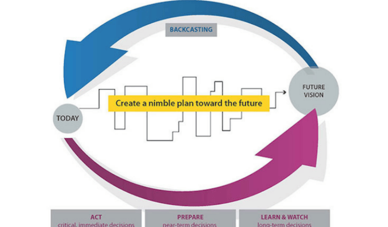
In contrast, foresight starts with the future and reverse-engineers what needs to happen today to achieve the most desirable outcome in the future. Foresight combines the processes of forecasting and backcasting (understanding how to prepare for what’s to come with a vision of the ideal community in mind). Trend scanning, signal sensing, and the understanding of external drivers of change will reveal potential roadblocks the community might encounter along the way toward its envisioned future. A good understanding of these potential disruptions is crucial to be able to create a plan—not just for what the future in 10 or 20 years will look like, but for how to achieve the community vision and goals while pivoting and adapting along the way.
Prepare for Multiple Plausible Futures
The practice of foresight is not a crystal ball and will not predict the future. Rather, it helps to develop ideas of what the future could potentially look like. Planners can use foresight to consider multiple plausible futures based on different potential drivers of change.
Exploratory scenario planning is a useful tool to create alternative futures. It can help planners prioritize different drivers of change and create scenarios with the ones that seem to have the biggest impact, that communities are least prepared for, and that are most likely or certain to occur. Exploratory scenario planning can be done in a variety of ways, including SWOT (strengths, weaknesses, opportunities, threats) analysis, formulating “what if” questions (what will happen if trend X occurs . . .), and using axes of uncertainty (a two-by-two matrix that interconnects different drivers of change to create alternative plausible futures and to assess future risks or opportunities).
Ideally, scenarios range from visionary (best case, success, or transformative scenarios) to expectable (conventional expectations) to challenging (worst case, failure, or dystopian scenarios) to cover all grounds when creating alternative paths towards the future.
Create a Nimble Plan for an Uncertain Future
Long-range planning is important, but it needs to be agile and adjustable. The goal of integrating foresight into community visioning is to prepare for uncertainty on the path towards the future.
As the world around us is changing, the community vision and the plan to achieve it need to be regularly updated and adjusted. What might be an ideal future from today’s perspective could be unachievable or problematic in five or 10 years. For instance, in 2005 no one would have thought that a telephone would change the ways people move around town, how planners connect with their communities, or how data is collected. Then the iPhone changed everything.
To create the needed agility and a nimble plan that allows for pivoting and changing directions, foresight needs to be practiced in cycles. Continuous observations, discovery, and sharing of signals and trends, including regular scenario planning to create alternative paths towards the future, are crucial.
It can be helpful to create a “trend radar,” categorizing trends and drivers of change as immediate (or critical), near-term, or long-term. This will provide guidance on what decisions are needed now, what planners need to start preparing for, and what they need to keep watching and learning about to understand potential implications.
Continuous monitoring of developments around us and on the horizon and adjusting the plan every one or two years will enhance the community’s resilience and preparedness for the future.
Conclusions
Planners play crucial roles in shaping inclusive and equitable futures for their communities—and they must be able to imagine the future to shape it and prepare for it. Practicing foresight and future literacy provides an opportunity for planners to create more resilient communities by better preparing for potential disruptions, by developing equitable solutions before a challenge arises, and by finding inclusive mechanisms to change directions when needed without leaving anyone behind.
This PAS QuickNotes was prepared by Petra Hurtado, Ph.D., research director at the American Planning Association.
Image Credit: American Planning Association
Further Reading from the American Planning Association


