Cities around the world seem to be stretching out physically and consuming land at a rate that exceeds population growth. As populations double, land use triples.
When city growth comes up in public discourse, the conversation almost invariably focuses on population. We speak of “booming” cities that have grown from, say, 2 to 5 million in just a few decades or declining cities that are hollowing out and losing residents at a rapid rate.
The common unit of understanding and measurement, in other words, is almost always the number of people. Measures of land use are often missing from the picture, despite the fact that cities grew much more in land use than in population between 1990 and 2015, according to data from the UN-Habitat Global Urban Observatory. In developed countries, urban population grew 12 percent, while urban land use increased by 80 percent. And in developing countries, population expanded by 100 percent while urban land use rose 350 percent.
Land use issues will become more critical as the world population exceeds 9 billion and 2.5 billion persons migrate to cities by 2050, according to the United Nations’ projections. Configuring urban areas and their available resources to support this massive inflow will be critical to sustaining human life on the planet, says George W. “Mac” McCarthy, president and CEO of the Lincoln Institute.
It’s a profound area of concern: How exactly are these rising urban populations changing global maps? Further, can we observe regular, even predictable, patterns? And are these trend lines, such as they are, sustainable over time?
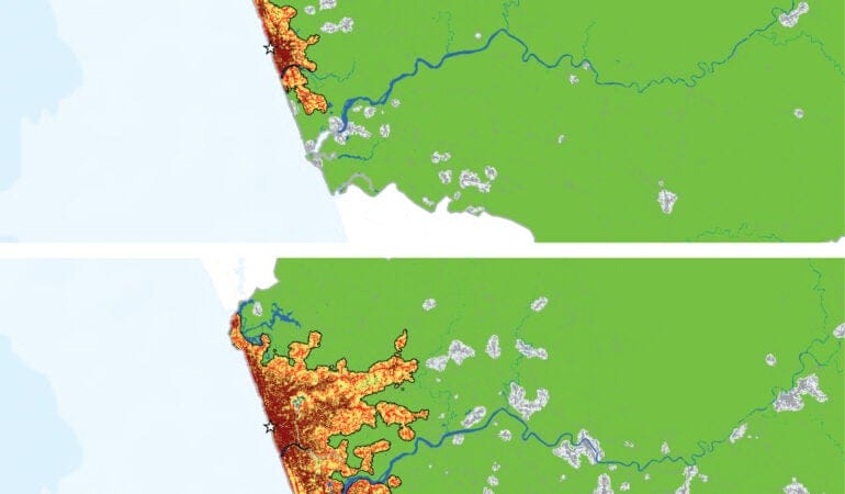
To date, there has been little scientific understanding of broad global patterns related to how city borders, systems, and land-use patterns are changing. But the newly revised, second edition of the online Atlas of Urban Expansion, first published in 2012, aims to fill this crucial gap in knowledge. Produced through a partnership among UN-Habitat, the New York University Urban Expansion Program, and the Lincoln Institute, the new Atlas performs very precise analysis of satellite imagery, coupled with population figures and other data, to study the changing nature of cities observed from 1990 to the present. The full report and data are set to be unveiled this October at the Habitat III global cities summit in Quito, Ecuador, as part of the implementation of the UN’s New Urban Agenda.
The new Atlas analyzes 200 cities (up from 120 in the 2012 sample), rigorously selected from among the 4,231 cities in the world with populations greater than 100,000 (as of 2010) that constitute a representative sample of large urban areas. The 200 cities in question make up about 70 percent of the world’s urban population.
The United Nations statistics division has now accepted and adopted this “UN Sample of Cities” as a way to conduct ongoing analysis of urbanization trends. “Cities, how they form, and the effects of urbanization on the quality of human life must now be treated as a science,” says Joan Clos, executive director of UN-Habitat, during the launch at UN headquarters in New York in June 2016: “The unprecedented confluence of climate change, population boom, and the rush to live in cities means that our critical human development will take place in cities.”
With unplanned settlement fluidly redefining many urban boundaries, it is crucial, experts and planners say, to produce a consistent method for studying cities as contiguous spatial units, not just administrative jurisdictions. The UN Sample of Cities also enables transition from an urban agenda based on country-level data to one predicated on city-based data collection and analysis.
Studying such a sample allows us to infer some generalizable rules about large urban areas, notes Atlas coauthor Shlomo “Solly” Angel, a professor and senior research scholar at New York University. “The sample accurately represents that universe,” he says of cities with populations of 100,000 persons or more, “so you can actually make statements about that universe given information about the sample. That’s the more scientific contribution of this Atlas.”
Land Consumption and “De-densification”
What, then, can be said of the world’s large cities, now that such representative data have finally been collected and crunched?
One reliably observed pattern is that cities around the world seem to be stretching out physically and consuming land at a rate that exceeds population growth. This tendency corroborates the findings of the first-edition Atlas, which indicates “falling density.” In the past, this was termed “sprawl,” and some refer to it now as “de-densification.” In any case, for a planet increasingly concerned with sustainability, energy efficiency, climate change, and resource scarcity, this is not a good trend: Density generally allows for greener and more sustainable living patterns.
Angel notes that there is a kind of rough statistical rule that emerges from the new Atlas work: As populations double, land use triples. “Even though people would like to see densification increase or at least stay the same, it doesn’t,” he adds.
Many policy makers have been unable, or unwilling, to see this reality unfolding in recent decades. Don Chen, director of Equitable Development at The Ford Foundation, says that the issue of sustainable growth is “very uneven in terms of planning officials’ awareness.” In many countries, he adds, “various orthodoxies are battling it out,” and frequently the “cards are stacked against us” in terms of changing norms and official attitudes: “For many, many decades, and in some countries for centuries, there have been incentives [for] building on virgin land.”
And even where there is political will for change, there are “multiple dimensions of capability to build upward, such as in-ground infrastructure,” Chen notes. Wider complex systems must be coordinated from a policy perspective in order to achieve greater density and land conservation.
In any case, the data analysis effort undertaken in the Atlas—which at root is intended to help define a new “science of cities”—may serve as a wake-up call. Angel says the Atlas can be a “tool for convincing policy makers that the expansion they must prepare for is considerably larger than their own little back-of-the-envelope calculations, or what their planners have in their master plans.”
Increasing density again will necessitate sacrifice and modification of existing norms for living standards in many places: It will require people to live in smaller apartments and homes, in multifamily housing, and in higher buildings. It also will frequently require redevelopment of low-density areas in cities.
McCarthy acknowledges that the data are “a little bit chilling,” as they reveal a pervasive pattern that signals huge trouble ahead. “It’s something that we have to stop—whether we call it ‘sprawl’ or ‘de-densification’ or something else,” he says. “We can’t continue to consume all of our best land with urban development. We still have to feed ourselves. We still need to collect water.”
He also notes many ill-fated attempts to build large housing units far outside denser urban areas, leaving millions of units across the world largely empty. This has happened in many countries, from Mexico and Brazil to South Africa and China. “Why is it that we continue to build these developments in the middle of nowhere and expect people to live there?” McCarthy says, noting that it is vital to link jobs and industrial activity with housing.
Clearly, smarter, more proactive planning is required for growth across the world, the project’s researchers say. That means finding the right ways to channel city growth spatially and to create the infrastructure—transportation, water, sewer, and other necessities—so the new settlements and housing units are serviced appropriately.
Moreover, it is also necessary, Atlas researchers say, for many of the big cities around the world—from Lagos, Nigeria, to Mexico City to Zhengzhou, China—to adopt more next-generation thinking about so-called “polycentric” cities. That will require moving beyond the traditional paradigm of hulking, monocentric cities with a huge urban core and instead creating polycentric networked hubs, whereby a metropolitan area will have many interlinked urban centers.
Signatures of Unplanned Settlement
The satellite imagery analyzed in the Atlas also highlights other key patterns that are both drivers and/or symbols of the overall de-densification trend worldwide.
One very granular mark is the lack of four-way intersections, a clear sign that roads are being laid out haphazardly, in a largely unplanned way. Such informality and unplanned development have been increasing over time across the world. The pattern, however, is strongly correlated with lower GDP per capita, and therefore is more pronounced in the developing world and global South. Linked to this observed pattern is an increase in urban block size, as shantytowns and unplanned settlements of many kinds grow without regard to transportation needs.
Indeed, the Atlas also suggests a pervasive lack of orderly connections to arterial roads, which are key to facilitating transportation to employment and economic networks. Built-up areas within walking distance of wide arterial roads are less frequent than they were in the 1990s, according to data from that decade. And more generally, there is simply not enough land being allocated for roads.
In addition, low-density tracts and small dwellings are unnecessarily consuming precious urban open space—parks and green spaces that can make dense urban areas more livable.
Angel says planners need to get ahead of the coming wave of urban migration and secure land for transportation, affordable housing, arterial roads, and open space. That needs to be done before settlement happens, when land prices subsequently soar and the logistics of moving populations become trickier. “This can be done at a relatively small cost,” Angel notes. He suggests that planners begin to “make some minimal preparations for it.”
Even in countries where there is a high degree of central planning, the data contained in the Atlas may prove helpful for diverse land management challenges.
“Compared to most cities in the developing world, Chinese cities are better managed,” says Zhi Liu, director of the Lincoln Institute’s China program. “The Atlas is still useful for China, as it provides accurate, visual urban expansion data and analytics to planners that could strengthen their understanding of the scale and patterns of urban expansion in their cities.”
The Atlas Data Challenge
Behind the new analytical insights produced by the Atlas, an intriguing and important backstory of data collection and analysis highlights future challenges for urban theory and monitoring of global cities, especially in developing nations.
Alejandro “Alex” Blei, a research scholar in the urban expansion program of New York University’s Marron Institute for Urban Management, said that assembling the 200 cities for the representative sample was no easy task, as there is no universally accepted definition for a metropolitan area. Researchers had to account for variables such as regional location, growth rate, and population size in order to ensure the sample was representative, and they had to create a careful and defensible methodology.
NASA’s Landsat database, a satellite imagery program running since the 1970s, was the basis for the spatial analysis. While that methodical, scientific dataset is of exceedingly high quality, the underlying population data, which was key for establishing migration- and settlement-related patterns, was frequently less than perfect.
“Some countries have very well-established data programs,” Blei said. But in other cases the data are very “coarse,” and large cities, particularly in the developing world, have only broad census zones. It is therefore difficult, at times, to make fine-grained insights about population changes in connection with land use shifts, as the researchers had to assume equal density over large tracts of the metropolitan area in question.
Scanning the NASA pictures, the researchers had to analyze pixels to assess whether there was impervious coverage surface or soils. They performed this task with powerful software according to well-established methods, but correlating it with population data was not always smooth. “Unfortunately, there’s not very much we can do if the data are not very good, but we did the best we could under the circumstances,” Blei says.
Evidence suggests the need for less variation in population data collection and synthesis across countries, in order to derive more actionable insights for policy makers in every country. And more global consensus is needed around the definition of cities. The U.S. Census Bureau defines them very precisely as “urbanized areas,” or “metropolitan statistical areas,” but they are frequently defined in more scattered ways by other countries’ data collection agencies. Asia and Africa—home of many of the fastest-growing cities, both in terms of population and geographic extent—suffer from a lack of granular city population data that speak to neighborhood-level change.
Global Nuances and Uncertain Futures
The publication of the new Atlas will, of course, join a long debate in policy and academic circles about how to measure sprawl, both high- and low-density, and the best models for addressing related issues. The new Atlas also speaks to a long research literature on the consumption of resources and quality of life in urban contexts.
Enrique R. Silva, a senior research associate at the Lincoln Institute who has specialized in Latin American planning and governance issues, notes that the Atlas research will continue to help advance understanding of government planning and rule-making, as well as residential pricing. The 2016 Atlas project includes surveys conducted with various stakeholders in cities that might yield insights on planning policies and markets, among other issues.
“It’s definitely an effort that is needed,” Silva says. “It’s a first-mover type of project. The measure of success will be the extent to which other researchers, whether through critique or support of the initial idea, can improve upon it and contribute to our understanding of how cities are growing, or even contracting.”
It will also help ground-level understanding for those studying or making policy in particular cities. Silva points to a place like Buenos Aires, which he calls a “classic case” where the expansion of territory is occurring faster than the population growth—and where many people are being displaced outward from the denser city core. Silva says that research by his Lincoln Institute colleague Cynthia Goytia has shown how lax land use regulation affects settlement patterns. Land markets and their regulations affect affordability, and this can result in unplanned settlements, her research suggests.
Neema Kudva, an associate professor at Cornell University who is an expert in growth patterns in India and South Asia, also praises the “very careful work” performed in the Atlas effort. But she worries that smaller cities—those under 100,000 and therefore excluded from the analysis—may see different dynamics that are subject to more variable patterns and experiences.
In trying to create “one science of cities,” she says, we may miss significant differences between small and big metropolitan areas, limiting our ability to imagine creative interventions. “The difference between small and big can be the ability to influence political processes, the ability to garner funds, to organize, to intervene,” Kudva says. “For a person like me who is interested in smaller places, things like the Atlas provide important suggestions, important points of reference, important counterpoints, but they are not always useful.”
Kudva also wonders if large-scale, emerging changes related to energy systems, global warming, sea-level rise, and political upheaval may alter worldwide land use patterns, compared to those observed in the past. The issue of falling density is potentially reversible, she believes. “That trend could change,” she says. “We need to play a more interventionist role.”
Still, better data and a more detailed picture of settlement patterns can substantially help address challenges common to cities of many different sizes. Chen, of the Ford Foundation, notes that research like the Atlas is necessary to combat issues such as unequal access to opportunity. “We need baseline data, and we need to understand the relationship between how we use land and other things.”
The issue of global inequality, which McCarthy calls the biggest “unassailable challenge” of cities, looms in all of the data. Beyond the layers of the Atlas’s global maps are stubborn facts and dilemmas that researchers and policy makers are only beginning to understand and address. “The biggest one is the absolute concentration of poverty and geographic isolation of large segments of the population,” McCarthy says, noting that sometimes 30 to 50 percent of residents in many large cities live in “deplorable conditions.”
Decent affordable housing that is meaningfully integrated into the economic network and flow of cities has to be a priority. Yet many national efforts to date have failed to achieve that goal. “That’s the thing that I find most vexing,” McCarthy says.
As the new Atlas is rolled out in October at the UN-Habitat III conference in Quito, that issue—and many others affecting the world’s fast-growing cities—is sure to be framed even more precisely and powerfully by the new, comprehensive data.
John Wihbey is an assistant professor of journalism and new media at Northeastern University. His writing and research focus on issues of technology, climate change, and sustainability.
Image by New York University Urban Expansion Program

Land readjustment is a vital but difficult and time-consuming process: formulating a sort of retroactive version of planning in neighborhoods that developed informally, with unsanctioned dwellings chaotically built in ways that leave some with no access to streets and paths. According to UN-Habitat, 863 million people around the world lived in such settings as of 2014, and the number could rise to 3 billion by 2050. The agreed draft of the New Urban Agenda for the Habitat III conference in Quito, Ecuador, notes that the “rising number of slum and informal settlement dwellers” contributes to intense challenges that exacerbate global poverty and its risks, from a lack of municipal services to increased health threats.
But evolving technology may facilitate revision of these organic layouts in ways that lead to minimal displacement and speed the absorption of such neighborhoods into a city’s formal structure, thus providing residents basic services—from sanitation and drainage systems to access for fire and medical emergencies. One of the more promising tools is Open Reblock, a platform currently in a pilot phase in areas around Cape Town, South Africa, and Mumbai, India. The project stems from a collaboration among Shack/Slum Dwellers International (SDI, is a network of urban-poor communities in 33 countries), the Santa Fe Institute (SFI, a nonprofit research and education organization), and Arizona State University.
SDI has long been involved in grassroots “reblocking”—essentially another way of characterizing the land-readjustment process. Luís Bettencourt, a professor of complex systems at the Santa Fe Institute, explains that his group, which focuses on “cities as systems,” began working with SDI a few years ago. There was a useful convergence in the high-level, statistics-and-data thinking of the SFI group with the on-the-ground “census” efforts SDI used in its work with informal-settlement communities.
SDI’s reblocking efforts could be painstaking. Residents led the process of mapping a neighborhood—on paper. Then they gathered at community meetings, arranged cutouts representing every local structure over that map, and began shifting them around to devise new paths and roadways. While this active collaboration was profoundly beneficial, the analog methodology wasn’t exactly speedy.
Ever-more-accessible digital technology has in recent years eased the process, says SDI Programme Officer: Data Management Anni Beukes. The group now uses a geographic information system (GIS) tool to map settlement boundaries and services available, and then relies on a separate tool for detailed household-level surveys and precise measurements of every structure. Given the wide availability of mobile devices, the process is open to—and indeed dependent on—direct resident participation.
Enrique R. Silva, research fellow and senior research associate at the Lincoln Institute, notes that similar tech-mapping tools are impacting such efforts around the world. “You can map something almost immediately,” he says, and involve community members in that process. He points to efforts, backed by the Lincoln Institute and others, that rely on “cheap and universal” devices and crowd-sourcing tools to reach similar goals across Latin America.
A master map that is available in digital form also creates new possibilities. Open Reblock is an example. It deploys a custom algorithm to read a digital map of an informal settlement and propose what it sees as the optimal strategy for reblocking it. (The algorithm is written to prioritize existing roadways and structures, echoing the traditional goal of minimizing displacement.) This process takes just minutes, at most.
“When I first showed it to our communities, they said, ‘You’re taking our paper cutouts away’!” Beukes says with a laugh. They weren’t wrong—and they weren’t actually protesting. (“At least the younger ones weren’t; some older participants,” she adds, “can be hesitant in their uptake of new technology.”)
But what Open Reblock produces is not meant to be a strict directive or an end point—community members can still tweak the results based on their direct knowledge and concerns. Indeed, Open Reblock depends on such participation—“creating a shared reality where people can play and create this future reality,” Bettencourt says. “It’s basically a town-planning tool, at the level of a neighborhood.” And by offering “a proof of principle and a starting point” for negotiations, he adds, it radically speeds up one of the toughest steps in the process.
Beukes says participants in the pilot programs have reacted with enthusiasm toward the new possibilities of this system. It means that a final plan will exist in a form that city officials can respond to more easily, and it ensures that all parties are considering the same geospatial data and planning scheme. “It’s a template for discussion,” Bettencourt adds, one that “puts everyone literally on the same map.”
With a grant from Open Ideo, Bettencourt’s team and SDI are working to improve the design of Open Reblock’s interface, with feedback from community participants in Cape Town and Mumbai. The entire project is being created in open-source code (available on Github), both to encourage improvements from anyone who wants to be involved and to make it easier to scale up future versions for widespread use anywhere.
The project is, of course, not a magic solution. Land readjustment can be contentious, and Silva points out that important issues around the value of any given settlement dweller’s property must still be worked out on a more individual, human level. Bettencourt and Beukes agree that Open Reblock is a supplement to, not a substitute for, existing processes.
Still, Bettencourt points to UN-Habitat numbers to speculate that there may be a million neighborhoods around the world in need of reblocking. “That’s a scary number,” he says. And it adds to the sense among some observers that there’s just something impossible about the effort—particularly when, on a case-by-case basis, the process gets bogged down over time.
But all this may be less intimidating from a technologist perspective. Think of the mapping and data-collection tools that have emerged in recent years as an early step that builds on the long-existing work of SDI and others. Open Reblock is just one more iteration of that trajectory. “I think we have all the ingredients, but we have to start doing,” Bettencourt says. “If there’s a system to capture the data and run proposals on top of it, that’s a big step. It doesn’t create the change, but it helps.”
Rob Walker (robwalker.net) is a contributor to Design Observer and The New York Times.
Leaflet | Map data © OpenStreetMap contributors, CC-BY-SA, Imagery © Mapbo

Holyoke, a city of about 40,000 in western Massachusetts, was one of the nation’s first planned industrial communities. Beginning in the late 1840s, Boston investors transformed what had been a farming area into a mill town, taking advantage of its location along the Connecticut River. The investors wanted to manufacture cotton textiles. But over time an elaborate canal system was built in the city to accommodate more and more mills, and the town became known for silk, wool, and paper manufacturing as well. In time, Holyoke came to be known as the “Paper City” because of its paper mills.
As the mills developed, the city prospered. With jobs plentiful, the town attracted successive waves of Irish, French-Canadian, German, Polish, Jewish, Italian, and Puerto Rican immigrants who worked in the mills, created small businesses, raised families, and built a city that reached a population of 63,000 by 1917 (McLaughlin Green 1939).
Then it all began to come apart—slowly. From a peak in the 1920s, local industry gradually declined as companies and jobs moved overseas or migrated to the South and West to be nearer raw materials and cheaper labor. By the time of the 2000 census, Holyoke’s population had shrunk to fewer than 40,000. Like other small industrial towns across the country, it was part of a fading era in the American industrial past, and the once-prosperous Paper City was fighting to keep its economic footing.
Fortunately, Holyoke had a big stroke of luck in 2009, when the city was selected as the site for what came to be known as the Massachusetts Green High Performance Computing Center (MGHPCC)—an environmentally friendly supercomputing complex intended to bolster what state officials call the Massachusetts “innovation economy.” Water power was once again key to the city’s success. Holyoke’s location on the banks of the Connecticut River offered access to low-cost hydroelectric power, while the river and the city’s many canals offered water for cooling, a major advantage in supercomputing. “Holyoke has struggled after losing its industry base,” says Kathleen Anderson, president of the Greater Holyoke Chamber of Commerce. “We had aging infrastructure that needed to be repurposed, loss of jobs, and other changing demographics. Holyoke had to think in creative ways and recognize the assets we had. Both human talent and the wisdom of acquiring the dam and its hydropower have been foundational to our rebirth.”
When the computer center opened in 2012, it represented an important first step toward improving Holyoke’s fortunes, but it wasn’t enough to restore its vitality. The city undertook a planning effort that produced a 20-year renewal plan to revitalize and redevelop the area where the MGHPCC is located, in the center of town. An important step in realizing the plan was the creation of the Holyoke Innovation District—an investment the state made through the Massachusetts Technology Collaborative that brought together local officials, business leaders, and community organizations to encourage local and regional economic development. “The attraction of the computing center to Holyoke really started our planning process around the Holyoke Innovation District. Really, we say it spawned out from the computing center,” Marcos Marrero, Holyoke director for planning and economic development and co-chair of the Holyoke Innovation District, said in a September interview (Desmarais 2015) with the Bay State Banner.
Leadership, Collaboration, Resurgence
That’s when the Boston Federal Reserve Bank entered the picture. Since 2008, the bank’s research staff had been studying older industrial cities like Holyoke as part of an effort to help revitalize another Massachusetts city, Springfield. Like Holyoke, it had seen better days. The bank conducted a two-year study partnership with Springfield that examined the challenges facing the state’s fourth-largest city, which continued to fail even as state government and nonprofits poured millions of dollars into revitalization.
One part of the study tried to glean lessons for Springfield from the fates of 25 other small industrial cities in the Northeast, Midwest, and upper South. The Boston Fed’s economists found that a handful of these cities had been able to either maintain or recover much of their economic stability, as measured by income, poverty rates, population, and economic vitality. Boston Fed researchers called them “resurgent cities,” and the researchers looked for common themes that explained their success. The cities, they found, faced similar challenges—poverty, changes in racial and ethnic makeup, and the loss of their manufacturing bases. But all were fighting through their challenges and shared a key driver of success: sustained leadership and collaboration among businesses, government, nonprofits, and community groups. “Time and again, our examination of the resurgent cities’ histories indicated that the resurgence involved leadership on the part of key institutions or individuals, along with collaboration among the various constituencies with an interest in economic development,” bank researchers wrote in a 2009 report (Kodrzycki and Muñoz 2009).
The bank researchers noticed that the source of local leadership varied from place to place. In New Haven, Connecticut, local colleges and universities worked with government officials and private industry to provide workforce training and funding to attract companies. In Providence, a nonprofit foundation worked with business executives to develop ideas and a consensus on downtown development projects. In Evansville, Indiana, a mayor initiated the turnaround in the 1960s, and it continued, thanks to an aggressive economic development campaign by the local chamber of commerce later on. Despite their differences, all these economic redevelopment efforts spanned decades, implying solid ongoing leadership.
All the efforts demonstrated the active collaboration of numerous groups and individuals as well. According to the Fed’s research, “Collaboration became necessary because economic transformation is complex, and because outsiders—such as state and national governments, foundations, and businesses that are potential sources of funding and jobs—often require proof of joint efforts in order to contribute to a city’s development.”
Rising to the Challenge
These findings led the Boston Fed to ask what it could do to help build the strong civic infrastructure that was critical to resurgence. The result was the Working Cities Challenge, which the bank created with the help of Living Cities, a New York–based collaboration of 22 foundations, financial institutions, and other partners.
The Challenge took the form of a competition among the smaller former industrial cities in Massachusetts. In the spring of 2013, 20 communities applied to participate. From the applicants, six cities were selected to receive a total of $1.8 million in grants to support projects that emphasize leadership and collaboration. Among the first six winners was Holyoke, along with Chelsea, Fitchburg, Lawrence, Salem, and Somerville. The goal was simple: to help save these struggling Massachusetts cities by supporting development of the tools they needed to help themselves.
The program was an important and unusual one for a federal reserve bank. The banks are better known for cranking out economic research than for mounting programs in the field. However, the initiative reflected Boston Fed President Eric Rosengren’s commitment to applying the bank’s economic research to the real world and to improving New England communities. And the concept is scalable, with nationwide potential to bolster cities and towns across the country that have struggled with 21st-century economic realities.
Tamar Kotelchuck, director of the Working Cities Challenge, says that the bank’s research on resurgent cities taught them that most struggling cities can do better. “Based on what we learned from studying resurgent cities, we got together with Living Cities and came up with the idea of a competition for multiyear funding to incentivize leadership and collaboration,” she says.
She says the bank decided to start with a pilot program in Massachusetts, with a focus on small and midsize cities. The target cities range in size from about 35,000 to 250,000 and share certain economic and demographic similarities, including a large number of poor families and low median incomes. “These cities had already formed a coalition to support their interests with the help of MassINC, a local think tank,” Kotelchuck says. “They called themselves Gateway Cities and had been working together on common economic and political problems for a few years. They had learned that working together gave them a certain amount of power that none had alone,” she says (Forman et. al. 2007).
Working Cities took a singular approach in attempting to help these cities, according to Andrew Reschovsky, a fellow at the Lincoln Institute. “What is unique about the Working Cities initiative is that, unlike many other urban economic development strategies, its focus is on improving the economic well-being of each city’s current low-income residents.”
The federal reserve banks can’t use their own funding to provide grants, but a number of willing partners stepped forward to aid Working Cities. Kotelchuck says the Fed’s role in the initiative includes designing and implementing the model in partnership with a steering committee, providing technical assistance, and helping teams build capacity through expert assistance, networking, and best practices. The grants are funded by several donors, including the state government; Living Cities; the Massachusetts Competitive Partnership, an association of the 16 largest employers in Massachusetts, focused on promoting economic growth; and MassDevelopment, the state’s development agency.
Kotelchuck says that when the bank and its partners put together the first competition in 2013, they left it up to the cities to propose how the grant funding would be used. “We didn’t tell cities what to work on,” she says. “The challenge is designed to help build collaboration around issues that are important locally.” A major requirement for a successful project, though, was that it should involve the private sector, government, and other local groups working together. “We were looking for projects that promoted systemic change,” she says. “Our goal was intended to help local leaders fix things in their cities.”
An independent jury evaluated the cities’ proposals based on criteria that reflect the Working Cities Challenge goals of collaboration, community engagement, and the use of evidence to track progress. The projects had to make a lasting contribution to improving the lives of low-income residents.
In January 2014, the first awards were announced. Of the six cities selected, four received multiyear grants, and two received seed awards. All the cities were combatting high unemployment, low student achievement, and an uncertain future. However, Kotelchuck says, “All the winning cities had distinctive proposals. No two were alike. They all addressed specific local needs, just as we had hoped,” she says.
For example, Fitchburg in north-central Massachusetts received a three-year grant of $400,000 for its eCarenomics Initiative—an effort to develop shared metrics for neighborhood health and well-being, with the goal of improving one part of town. Chelsea won a three-year grant for its Shurtleff-Bellingham Initiative, designed to reduce poverty and mobility rates by 30 percent in the struggling neighborhood. Salem received a $100,000 seed grant for its plan to bring one low-income neighborhood’s economic indicators in line with the rest of the city by focusing on economic development, small business development, workforce development, and leadership development. Somerville also received a one-year seed grant of $100,000 to support a workforce training program for out-of-school “youth” aged 18 to 24.
The largest single award, a $700,000 three-year grant, went to Lawrence in the northeastern part of the state. The award was for the Lawrence Working Families Initiative, whose goal was to create a Family Resource Center designed to increase the incomes of parents of local school children by 15 percent over a 10-year period. The initiative is led by Lawrence Community Works and the local school system, with support from several employers and nonprofits in the area. “The Lawrence school system had gone into receivership in 2011,” Kotelchuck explained, so focusing on families and schools was a logical choice.
The city also had economic characteristics that fit the Working Cities’ model. Its median household income was half the statewide median, and its poverty rate was almost triple the statewide rate. “The city’s population is 70 percent Hispanic, and unemployment was a problem,” Kotelchuck says. Many of the problems the city faced spilled over into the schools. “The goal of the Family Resource Center is to help families in as many ways as possible. It provides financial coaching, crisis support, and other services to strengthen families,” she says.
Beyond the family center, a large part of the initiative is focused on what Kotelchuck calls “authentic parent involvement” in the schools. The initiative created community education circles where parents, teachers, and students work on specific problems in the schools. “The goal is to get parent buy-in and involvement in the school system,” she says. So far, the program has involved 400 parents, hired a family coach, and placed more than 30 parents in jobs, according to Kotelchuck.
Holyoke received a $250,000, three-year award that is being used to implement SPARK (Stimulating Potential, Accessing Resource Knowledge). This downtown “entrepreneurship and social venture development center” aims to increase business ownership, particularly among the city’s residents, including the Latino population, which accounts for 60 percent of the population. The project team that created the program is made up of representatives from the city, the chamber of commerce, the Holyoke Public Library, a one-stop employment center called CareerPoint, and the local nonprofit Nuestras Raíces.
The SPARK program is “geared toward identifying, recruiting, and stimulating Holyoke residents and organizations that have a ‘spark’ or desire to move their innovative projects or business proposals from concept to reality by emphasizing a whole-community approach to entrepreneurialism, individual learning, and leadership training,” according to the city. In short, it’s designed to help prospective business owners establish business plans and figure out how to get operating.
Another goal is to tie members of the downtown Holyoke community into the Innovation District the city created around the supercomputing center. “The city has a big data center,” Kotelchuck says. “But that alone won’t necessarily help Holyoke’s low-income people. The question that SPARK addresses is how do you build upon the assets of Holyoke’s immigrant population and make sure people benefit from the development that’s going on around the innovation district.”
City officials agree. “This award is more great news for the future of the city’s Innovation District,” Mayor Alex Morse said when the grant was announced. “We’ve been working hard to position Holyoke to compete in the modern economy, which requires us to stimulate innovative projects and business ventures. With the collaboration of some of Holyoke’s finest organizations and community leaders, this funding will allow us to assist local residents in bringing their innovative ideas to fruition.”
Kotelchuck says that many cities try to attract young professionals and focus on tech jobs. They see other cities succeed using that model and copy it, but not always successfully. “If we don’t help low-income residents,” she says, “all we’re doing is moving poverty from place to place, and that helps no one. The Working Cities initiative helps people where they live. It helps people who wouldn’t otherwise have jobs.”
“Many cities chase the newest, flashiest strategy to revitalize themselves, but ultimately it’s not the newest trend that revitalizes a city,” she says. “It’s the effects of many ideas over time, and it only happens in cities with community engagement and collaboration. Our advice is to look at what you have and build systematically on it.”
She says that in monitoring the Challenge, she has noted differences in how cities think about their futures. “Some cities say: We have so many problems; give us some money,” she says. “But others say: We have these resources. We have some energy. We need help realizing our potential.” She says that revitalization efforts will require a decade of effort or more. The Fed’s goal is to provide a three-year leg up on the effort.
It can also spark broader interest in the cities’ revitalization. Recently, Holyoke SPARK received an additional $56,000 from the Massachusetts Growth Capital Corp., a quasi-public agency that supports small businesses, to help the program offer more classes, provide mentoring for entrepreneurs, and support a micro-enterprise loan program for those who qualify. It also received additional funding from the city’s Community Development Block Grant this year.
Signs of Progress
The Fed and its partners are happy with the project’s results so far, Kotelchuck says. And the bank recently announced a second and third round of grants, for cities in Massachusetts and Rhode Island. Eventually, she thinks the idea could spread to other Federal Reserve districts. “It’s a new model for Fed involvement in these communities. Other Feds are showing interest, and we would be delighted if it takes root in other districts.” Bank President Rosengren says that the Boston Fed plans to expand the program to other New England states at the very least.
The Working Cities program shows great potential to spread farther. Small cities and towns all over the country have been batted around by changing economic fortunes in recent decades. They deserve a chance at becoming resurgent cities too, and it’s gratifying to see an organization like the Boston Fed putting its brains and influence behind improving their future. There is no silver bullet, no guarantee of success, but the Working Cities Challenge shows that good things can happen with time, commitment, elbow grease—and a little money.
This point was underscored by the Lincoln Institute’s Reschovsky: “Although all the cities currently involved in Working Cities need more economic and fiscal resources, the key to the success of the initiative will be the combination of additional resources and the development and nurturing of local nonprofit, government, business, and social institutions.”
That certainly seems to be the case in Holyoke. Lately, it has even developed a little national “buzz.” In the February issue of Popular Mechanics magazine, the editors designated the nation’s 14 best startup cities, saying they wanted to identify “the next wave of cities building an ecosystem to turn innovators into entrepreneurs.” The list features smaller cities from across the country. Holyoke made the list at number six (Popular Mechanics 2015).
Inevitably, the city’s chief advantage is a familiar one. “We have cheap energy,” Mayor Morse wrote in a description of innovation in Holyoke for the magazine. “On the city’s eastern border, the Connecticut River drops 57 feet as it presses south. When the city was founded, in 1850, the river powered waterwheels for paper mills; today it generates inexpensive, clean energy.” He also mentioned the brick paper mills, signs of the industrial past that have been repurposed as “attractive industrial work spaces.”
“Holyoke has gone back to where we started,” the Chamber’s Anderson says. “Our ancestors dug a canal system to harness power, and now we are still harnessing it as green energy to power a new economy.”
Billy Hamilton is executive vice chancellor and chief financial officer of the Texas A&M University System. He was for 16 years the deputy comptroller of public accounts for the State of Texas. Since 2007, he has written a weekly column for State Tax Notes.
Photograph by Jeffrey Byrnes
References
Desmarais, Martin. 2015. “The Holyoke Innovation District Finds Creative Solutions to Revitalizing the City.” The Bay State Banner. September 10, 2015. baystatebanner.com/news/2015/sep/10/holyoke-innovation-district-finds-creative-solutio/?page=3
Forman, Benjamin, David Warren, Eric McLean-Shinaman, John Schneider, Mark Muro, and Rebecca Sohmer. 2007. Reconnecting Massachusetts Gateway Cities: Lessons Learned and an Agenda for Renewal. The Brookings Institution and MassINC. February 2007.
Kodrzycki, Yolanda and Ana Patricia Muñoz. 2009. “Lessons from Resurgent Cities.” Federal Reserve Bank of Boston. 2009 Annual Report. www.bostonfed.org/about/ar/ar2009/lessons-from-resurgent-cities.pdf
McLaughlin Green, Constance. 1939. Holyoke, Massachusetts: A Case History of the Industrial Revolution in America. New Haven, Connecticut: Yale University Press.
Popular Mechanics. 2015. “The 14 Best Startup Cities in America.” Popular Mechanics. February 2015. www.popularmechanics.com/culture/advertorial/g1859/the-14-best-startup-cities-in-america